Tralee is the capital of County Kerry, the south-western corner of Ireland. In 1828 funding was sought for a canal to link the town to the sea at Blennerville. The canal, only about 2 km long, opened in 1846; it closed in the 1930s when a deepwater quay was built at Fenit.
The canal was restored in the 1990s/2000s by the Office of Public Works, for around IR£1,000,000, but is, I think, controlled by Tralee Town Council and Kerry County Council. The town basin seems to be called a marina but the term “Tralee Marina” seems to refer only to a block of flats. I am open to correction on all of that. I would also like to know who the lockkeeper is, how he or she is to be contacted and what the canal charges are. Reliable information on the size of the lock and the depth of the canal would also be useful.
There is an interesting account of the canal here, but I think the author is wrong about the bridge: the Ordnance Survey map shows it as a swivel bridge. This page mentions an article about the canal.
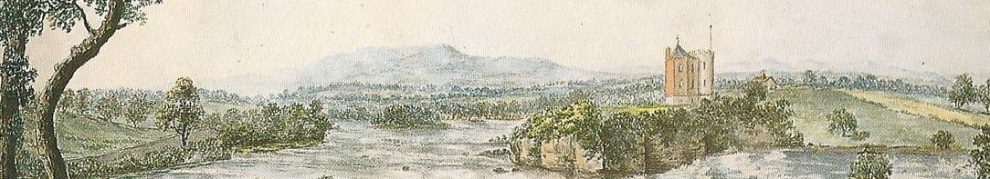
Here you can see the whole of the canal, running from Tralee (on the right) to the sea at Blennerville on the left. You may have to select the larger image and move down and to the left a bit: I can’t work out how to get these links to start in the right place.
The road runs alongside the canal as far as the swing bridge. You can walk down the north bank from there to the lock; there is also a road that leads to the lock.
Tim Boddington of Bollington has very kindly sent me his photos, taken during restoration work on the lock — and in sunshine. I have inserted some of them below. Many thanks to Tim.
The sea lock

The upper gates. Note the railing along the lock on the far side
I presumed that the paddle mechanisms were the vertical red things about half way along each gate, with (again, I presumed) hydraulic hoses leading to them. And so indeed, from Tim Boddington’s photos, it proves to be.

Gate paddles (Tim Boddington)

The other side of the upper gates

The lock controls

The lower gates

Groove for stop-planks below the bottom gates. The restorers used bunds rather than stop-planks

The lock being restored (Tim Boddington)

Equipment (Tim Boddington)

Work in progress (Tim Boddington)
The next photo shows the view out to sea.

Stone bollard at the downstream end of the lock
That bollard is one of the few pieces of lock furniture visible. In the next photo, there is no sign of any bollards.

Looking back up along the lock chamber

What looks like a flight of steps in the wall below the lock

The basin above the lock

Close-up of the shed (Tim Boddington)

The lockside cottage (Tim Boddington). This is not the lock house (see below)

Looking out to sea over the lock
Along the banks

The lock house

Is that an overflow or something?

Note the effects of the wind. It must have been fun working a sailing ship along here
The swing bridge

The only boat on the canal: a barge tied at the quay below the swing bridge

The quay sans barge (Tim Boddington)

The downstream side of the bridge

The upstream side of the bridge, with Blennerville windmill in the background

Here's what it's like when it's not raining (Tim Boddington)

Modern barriers and other equipment

Could this lot be part of the bridge mechanism?

Looking downstream from beside the bridge towards the lock and the sea

Looking upstream from the bridge towards the town
The town basin

Looking towards Tralee when it's not raining (Tim Boddington)

The town basin

The other side of the basin
There is another Tralee-related story here.


I notice that the satellite image shows the lock undergoing its reconstruction
Well spotted, Tony!
bjg
Brian
The original bridge was most certainly a swivel bridge – it appears on some of W. Lawrence’s photographs (showing the windmill in the background).
Fred
Thanks, Fred. I thought the chap on http://www.focuskerry.com/james/canal.html might have been using the word “drawbridge” loosely to mean any type of moving bridge, but he does say “pulled up” (despite the absence of any mechanism).
The windmill seems to be the most successful of the Tralee/Blennerville heritage projects.
bjg
Pingback: Blennerville and the Tralee Ship Canal, Tralee, Co. Kerry « Around Ireland
Why is this not part of Waterways Ireland operation? Unless it is connected to people who have some professional experience of operating a waterway (and I realise you also have your doubts there) the whole thing is likely to become a white elephant. I realise that the T&D railway restoration has also come and gone at some expense. Expensive bits of kit (those which require insurance and maintenance) come with costs. I can well imagine a local authority maintaining a high tech sea lock (without manual operating gear which in the 19th century was all they needed). The sad thing about all this – and I thought this when I went through each electric lock on Shannon Erne – is that the outsider realises that the Irish relationship with the EU has proved very adept at securing funding but seems more challenged at relating the spend to projects which will pay back and have a life. And then the EU taxpayer in one of the more sceptical parts of Europe scratches their head. I came here after your discussion of the Western Rail Corridor (and I came to the opening day of that and rode on it the next day). If the WRC becomes another example of the tendency, it becomes very sad indeed. I had high hopes for a full circuit of the margin from Sligo Limerick Rosslare but it started to look very creaky to my eyes when they closed the line through South Wexford. Opened one bit of the link, shut another. What’s going on?
Tralee, and County Kerry, have benefited from public money because TDs have had crucial roles, either in or supporting the government. The canal, the railway, Blennerville Windmill, and the ludicrous Jeanie Johnston, were developed by Tralee or County Kerry local authorities as tourist attractions. The problem with the canal is not the technology: it’s that there is no traffic. Nobody wants or needs to take a boat up the canal to Tralee. So the canal is pointless. I think the WRC is too: even Limerick–Waterford gets very few passengers, and the bus service is far more convenient. But local enthusiasts, and public money spent in the constituency, both swing votes, and project appraisal is very weak. bjg
The Canal is now tidal again, since one of the gates has been removed last week:


Thank you for that. I have made it the subject of a new post and linked to a Radio Kerry story on the subject. bjg
Pingback: The end of the Tralee Ship Canal? | Irish waterways history
Pingback: Fish in canal shock | Irish waterways history
Pingback: Tralee Ship Canal | Irish waterways history
What are the 2ladie statues called or what is their meaning
Is it possible to enter that town basin by boat now to stay a couple of days or those lock and bridge just decorations? How to find lock keeper details?
When they were reinstalled the lock (sluices and gates) were working, but I think that they no longer do so. You might be able to get in using one set of gates at the right state of the tide but I don’t really know, and I know nothing about the channel outside the gates. (It’s some years since I last checked on Tralee.) I suggest contacting Kerry County Council’s Tralee office https://www.kerrycoco.ie/council-offices/tralee-municipal-area-office/
bjg