I have been no further up the Slaney than the premises of the estimable Wexford Harbour Boat and Tennis Club, whose history is told here, but it is a gap in this site’s coverage that needs to be filled.

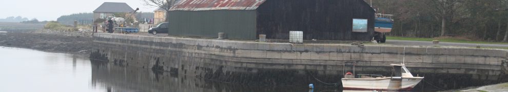
Wexford Harbour Boat and Tennis Club in 2004

Boats moored off the club
Wexford

Wexford quay
Wexford is at the downstream end of the Slaney, close to the Irish Sea.

Wexford sandbanks

Sands in Wexford bay
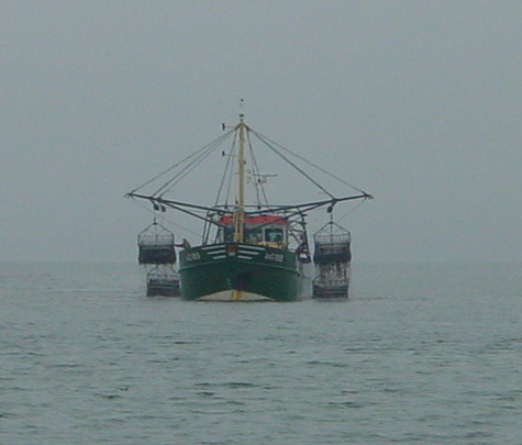
Wexford mussel dredger
Just upstream of Wexford is a large bend in the river. The Sow flows into the northern reach of the bend; it was navigable to Castlebridge.

Wexford, the River Slaney and the River Sow
Much effort was put into land reclamation; you can read about that (and much else) on the excellent Carnsore Chronicles website. The impressive pumping station at Drinagh is now the base for the Wexford Wildfowl Reserve.

The pumping station at Drinagh
Down The Slaney
It is possible to canoe on the Slaney well upstream of Enniscorthy, as the members of the Tullow Kayak Club will no doubt attest. F T E Prothero canoed downriver from Tullow, to which he had travelled by train, in 1894.

The Slaney
In F E Prothero and W A Clark eds A New Oarsman’s Guide to the Rivers and Canals of Great Britain and Ireland, a Cruising Club Manual [George Philip & Son, London 1896], Prothero wrote:
The isolated position and difficult character of this lovely river perhaps account for the fact that when, in the autumn of 1894, the writer of this article arrived at Wexford with a canoe which he had worked down the river from Tullow, he was told that no one else had done so for 18 years. […]
There is little likeness between the Slaney and her neighbour the Barrow. She has a sort of general likeness to the Cork Blackwater — not perhaps quite so beautiful, though she is on a larger scale, and very much more formidable, owing to her rocky cataracts. She is everywhere perfectly transparent, running over a beautiful gravel bottom, and not much afflicted with weeds. The transition at Enniscorthy from a swift, clear, shallow stream to a deep tidal river is remarkably abrupt.
There does not seem to have been any carrying of goods above Enniscorthy, though, so let us follow Prothero downstream from there. The numbers he gives are miles from Tullow.

The OSI map shows no quays or landing-places in Enniscorthy; they were built later
I have interspersed some extracts from Ordnance Survey 6″ maps, which were made between 1825 and 1846; they don’t show some features, eg railway stations, to which Prothero referred, and you may prefer to follow him on the OSI 25″ map (of around 1900) instead. However, they do show some features that may be of navigational interest. There are some boathouses, probably for pleasure boats rather than carrying craft, and some indentations that might have been small harbours or landing-places.
28 Enniscorthy Bridge. Station. Bennett’s Hotel. Ruined castle. Close by is Vinegar Hill (1798). The river now becomes tidal.

Small inlets in a few places, like this one, might have been boat landing-places but might equally have been natural indentations
30¾ Black Castle (l). Remains of a Franciscan monastery.
31⅜ Edermine Ferry. Station (r). Edermine House, just below (l) (Sir J Power).

Kilgibbon House. A bridge has now replaced Edermine Ferry; it is said that gas bottles aid navigation beneath the bridge
32⅞ Macmine Castle (r). (Mr Richards), and King’s Island.

Boat House at Merton by King’s Island
33¾ Macmine Station (r).
34⅞ Bellevue and Brookhill (r).

Boat house at Bellevue
36 Lonsdale (l).
37 Killurin Bridge. Station (r).
37⅝ Newtown House (l).
38¼ Healthfield (r).
39⅜ Ardcandrisk (r).

Cullentra, which had a boat house, is a little downstream of Ardcandrisk
40⅞ Carrig Bridge. Crosses at a point where the river suddenly narrows, spreading out again into a wide reach immediately below. Remains of Fitz-Stephen’s castle. Monument to Captain Valloton, treacherously murdered by rebels (1793).

Ferrycarrig bridge, which had a drawbridge opening section to allow masted vessels through
42½ Park Point Buoy. In the reach below Carrig the place which is conspicuous to the left front is Castle Bridge. Wexford is out of sight to the right until Park Point is rounded.
43 Wexford. Wexford Rowing Club boat-house just above the bridge (r). White’s Hotel. Ruins of Selskar Priory. Fine modern R C Cathedral, by Putin, on the top of the hill. The streets are extraordinarily narrow, and the town reminds one of Falmouth. Steamers weekly to Liverpool and Bristol. The boat can also be sent by rail, 28 miles, to New Ross on the Barrow […]. Wexford harbour is a wide lagoon, with a comparatively narrow passage to the open sea, between Raven and Rosslare Points.
Canoes have been round along the coast to Waterford, but from Rosslare to Hook Point is 40 miles of open sea, and off the latter point is usually a nasty lop. A half-way landing can be made at Crossfarnoge or Kilmore, nearly 30 miles from Wexford.

Kilmore Quay from outside looking in

Kilmore Quay from inside looking out
Commercial carrying on the Slaney
In the 1830s the Railway Commissioners attempted to assess all traffic — passengers, goods and everything else – by land and water within Ireland. They gave the results for inland navigations in Appendix B No 6 of their second report. Here is what they said about the Slaney.
Slaney Navigation
Description. — Extracts from Communications received from R D Gibbons Esq dated 23rd and 29th November 1836
The Slaney River is navigable for any vessel that can come over the harbour bar to about six miles above Wexford: but scarcely any ever go beyond the draw-bridge. It is a natural river, and no means are used either to maintain or improve it. The entire traffic is carried on by Cots (flat bottomed Boats of 15 to 20 tons), these can go always loaded to within about 4 miles of Enniscorthy, generally to within about 2 miles, and sometimes the entire way.
The tide flows up the river about 10 statute miles, so as to affect the water; but the level of the river is affected by back water up to the town of Enniscorthy, which is about 18 statute miles from Wexford by the River, and 14 by the Mail Coach road.
There is no source of ascertaining precisely the amount of traffic on the River, but a calculation has been made by persons well acquainted with the matter, by which it would appear, that the traffic averages about 1200 tons per week, or about 60,000 tons per year. Down the river almost exclusively Grain, and up Limestone for Manure, Coals, Timber, and imported Ship Goods.
The Boats vary from 15 to 20 tons, and draw from 3 feet 3 inches to 4 feet waterr. The Boats are occasionally interrupted by a scour at about 4 to 4½ miles from Enniscorthy, but this occurs only when the waters are very low and at neap low water. The scours, where they are generally stopped, are about 2 to 2½ Irish miles from the town.
The figure of 60000 tons sounds very high: it’s more than the [measured] totals for the Lagan and the Lower Boyne plus the [estimated] Suir [Carrick to Clonmel] put together.

The draw bridge
It is particularly hard to understand if, as Gibbons said, few went above the drawbridge at Ferrycarrig. With Enniscorthy accounting for little of the traffic, most of it must have been between Castlebridge and Wexford — or from the sea to either place, in which case it’s coastal rather than inland navigation. I would welcome enlightenment on this.
Cots
The cots were carrying cots rather than fishing cots like that shown here (or indeed here or here). These racing cots, and this one, seem to be larger than fishing would require [although I am not an expert on the subject] but smaller than a carrying boat. This, which seems to be a video of the launch of a reproduction gabbard, may be more the size, but I have no more information about it.
Pills
There seems to have been some traffic upriver, though, because apart from the inlets and boathouses the OSI map shows three other features of interest.
I wrote here about pills in general and St John’s Pill in Waterford in particular. I found three pills on the Slaney.

Pill at Polehore
The other two are described as landing pills; the phrase is one that I have never come across before and that even Messrs Google are not familiar with.

Landing pill near Kilgibbon

Landing pill at Mackmine Castle
They look like short, artificial [because straight or angled rather than curved] cuts that would allow boats to shelter from the current while loading and unloading; the Mackmine Castle example also gets nearer to what was presumably an inhabited dwelling. I would welcome more information about landing pills.
![]()
Cecil Miller’s guide to the Slaney is available here but AFAIK it has not been updated for many years.
[wwse94]


I have two postcards of the landing stage at Cullintra. They are both the same picture ( one in black and white, one in colour ). There is a man wheeling a barrow on the landing stage on the cards . Would you like a picture of each postcard, if so let me know so.Yours Sincerely, John A. Whelan.
Yes please! I’ll email you direct. bjg
Dear bjg,
Just had a look at your fascinating information on the Slaney – I’m especially interested in Enniscorthy where some ancestors lived. Re- the “cots” – which you indicate were the boats plying the Slaney (trade), postcard images and photographs of Enniscorthy from the late 1890’s? in the National Library of Ireland catalogue show quite large double ended sailing boats moored at the quay in Enniscorthy. These don’t seem to fit the description of “cots”?
Any comments?
Tremendous site you have made!
Yours sincerely, Bill Washington (Melbourne, Australia)
Thanks, Bill.
In general, the word “cot” in Ireland has been applied to two boats of very different types: the large(ish) flat-bottomed cargo-carrier used mostly on calmer (inland lake and river) waters and the narrow cot used for (mostly, I think, salmon) fishing on rivers (mostly, I think, on their tidal, or at least downriver, portions). Enter “cot” in the site search engine to get some idea of the geographical dispersion.
Another point is that the usage may have changed over time: the piece I quoted was from 1836. However, I am by no means an expert on traditional boats, but I have to hand the excellent Traditional Boats of Ireland [Críostóir Mac Cárthaigh ed; The Collins Press, Cork 2008]. It has three separate articles about cots in the Wexford area.
The first article is by Hal Sisk on “The Rosslare Herring Cots”, Rosslare being (as I am sure you know) just around the corner from Wexford. It reproduces a painting from 1796: the cots shown therein are three-masted sprit-rigged vessels. Sisk says
In “River Cots of the Southeast”, Darina Tully makes much the same point:
She says that the Slaney salmon cots, used for draught netting, were the smallest of the family, traditionally double-ended but nowadays mostly transom-sterned. But it is her next chapter, “The Sailing Cot or ‘Gabbard’ of the River Slaney”, that I think is most relevant here. She uses a photo — which I think is this one from the NLI, trimmed — and captions it
Early gabbards were 40 ft long; later vessels were 60 ft and capable of carrying 80 tons. They were double-ended, with their maximum beam about one third of the way back and with “a long trailing rudder”. A 30 ft mast with a gaff sail was easily lowered for going under bridges, but the boats went with the tides and the crews also used poles. There were no trackways or towing-paths. The crews of the gabbards were known as “cot men”. The last working gabbard was broken up in the 1960s.
All of that is extracted from Darina Tully’s article, as is this sentence, which I think answers your query:
I hope that helps.
bjg
Compliments on the post, I found it very interesting. One small point you should look at is the pumping station, I believe it is the one at, Ardcavan, Drinagh is an area to the south of Wexford. The pumping station for the south slobs is on private property owned by the Gallagher family.
Hi
Fantastic information, I am putting together a Book/Documentary on the trading cots of the River Slaney, I would appreciate any information you could give me
Jer Ennis
I’m afraid that I am by no means an expert on the Slaney cots. Darina Tully knows more than anyone else I know. bjg
Thanks for that, would you have contact details for Darina, or I’m happy to pass mine on
I’m afraid I don’t. I poured milk over my laptop some time ago: I didn’t lose many files but I did lose my older emails, including her email address. As far as I can recall she lives in Wexford. The Heritage Council might have contact details for her. Sorry about that. bjg
Such an interesting read. The Slaney is our land boundary and I would really like to have a large map (in the era of the one you have used here) for our house. Do you know how I could get a hold of such a map (& any ideas on having it printed most welcome too!). Many thanks Fiona Keane (fewheal@hotmail.com)