
Padhraic Conneally left a comment on my third page about the Rockville Navigation. He made an interesting suggestion that caused me to look at the OSI maps around the Corrib. It seems that there might be another small navigation to the west of Lough Corrib and, because further information would be welcome, I reproduce Padhraic’s comment and my response here.
There is supposed a similar [ie similar to the Rockville] navigation on the Corrib from the old river to Ross lake via Moycullen lake.
I have been up a channel from the old river in a cruiser almost up to the realigned main road but never further. Fr O’Reilly SJ who was a companion of Maurice Semple author of the series of books on the Corrib was reputed to [have] made the trip in a canoe cutting lots of farmers’ barbed wire on the way!
My response:
Looking at it on the OSI maps, the ~1840 (or thereabouts) Historic 6″ map has a quay at the south end of Ross Lake. From there it seems to be possible to get as far as Lough Down, north of Cloghaun. A lot of the channels are straight, suggesting that they’re artificial.
The later ~1900 Historic 25″ then shows another straight channel from Lough Down, through Cloghaun to Moycullen (Ballycuirke) Lough. From the far side of the lake, an artificial-looking channel curves to the Corrib, joining it at this point. So it might be that the system was developed in the early nineteenth century but linked to the Corrib only in the later part of the century. It might have been constructed for drainage, but that wouldn’t stop it being used for navigation as well.
I hadn’t heard of Fr O’Reilly but I do have two of Maurice Semple’s books. I must have a look in them. If anyone else has information about this, it would be very welcome.
Zara Brady of IWAI Corrib Branch then very kindly took up the investigation. She asked Trevor Northage (www.anglingcharts.com) about the old navigation canal from Lough Corrib. This is what he said:
The canal runs from the bottom of Moycullen bay; it’s called Ballyquirke or Ballycuirke canal, depending on the map you look at. Ross lake is a good way from the Corrib. The canal runs into Ballycuirke lake, on the south side of Moycullen. […]
I am grateful to Zara and to Trevor both for the information and for permission to quote it here. Trevor’s website is well worth a visit, by the way, including as it does underwater photos of Corrib wrecks.
The Ballycuirke Canal
This first map, from the ~1840 OSI, shows Ross Lake, the top end of Ballycuirke Lough and Lough Corrib.

Ross Lake, Ballycuirke Lough and the Corrib
Switch to black and white because the boundary lines are less obtrusive that way. The next ~1840 extract shows the bottom end of Ross Lake at the top, with a quay marked. It’s not clear whether there was a channel linking Ross to the next (small, unnamed) lake, but that lake does have a channel to Lough Hemushmaconry and there is another from there to Lough Arobaun.

Ross Lake to Lough Arobaun
There is also a clear channel from Lough Arobaun to Lough Napark, Lough Pollalahy and Lough Down, but after that there is only a stream to Cloghaun.

From Lough Arobaun to Cloghaun
I’m unable to make out whether Cloghaun Stream then flows into Ballycuirke Lough (bottom right on the next map).

Cloghaun to Ballycuirke Lough
Switching back to colour, and zooming out, we can see that there is no channel running east from Ballycuirke Lough to Lough Corrib.

Ballycuirke Lough and Lough Corrib
The next map is from the OSI ~1900, and there is now a channel from the east side of Ballycuirke Lough to Lough Corrib. There is also a straight channel running into the west side of Ballycuirke Lough.

Ballycuirke Lough to Lough Corrib ~1900
Here is the channel further up, emerging from Lough Down and running straight towards Ballycuirke Lough. There is even a bridge over it at Cloghaun.

The channel from Lough Down
And here is the channel upstream of Lough Down.

The channel between Lough Aroraun and Lough Down
Unfortunately, at time of writing the OSI ~1900 map is not working for the next stretch, up to Ross Lake. Before it crashed, I formed the impression that there still might not be a channel from Ross Lake itself, but I can’t check. On the other hand, the Google satellite view does suggest that there is now a channel; you can have a look for yourself. This link should take you to Cloghaun.
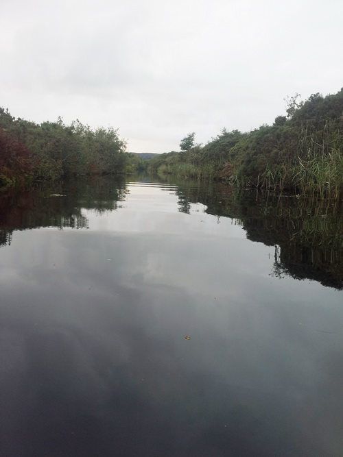
Canal scenery [(c) Declan Maher 2012]
There are photos of a canoe trip from Ballycuirke Lough to Lough Corrib here; Galway County Council uses the name Ballycuirke Canal here [PDF] and there is a very interesting discussion of the drainage aspects here. Note Mr John Madden’s mention of the Gortmore Canal: another one to be investigated? And Mr Timothy Kenny says that the canals were navigable ….
The canal at the back of Madden(s)
Trevor also said:
I’ve been up the canal at the back of Maddens — there’s a houseboat up there. It leads from halfway up the old river past the golfcourse.
And Zara commented:
The Canal at the back of Madden that Trevor refers to is off the old Friar’s Cut. Boaters still use it, but only when the lake level is fairly high.
I think this is what Trevor and Zara have in mind.

The location, shown on the OSI ~1840 map

Zooming in on the OSI ~1900 map
Addendum April 2015: notes on navigating the Ballycuirke Canal as far as Ross Lake.![]()
As usual, extra information will be welcome; please leave a Comment below.
[wow50]


What makes this one of the most compelling blogs that I follow is that you expand our knowledge so much. You keep coming up with new canals and navigatiosn to add to any directory.
Thank you. bjg
11 March 2015: I’ve moved a comment by Kyran O’Gorman to here. bjg
==============================================
I have travelled from Lough Corrib via Ballyquirk and the Downs lakes into Ross lake several times, first in 1981 and the last time in 2011. It is reasonably easy if you know where to look for the connecting canals, but is overgrown in places. It is definitely constructed, as an engineer I assumed (without evidence) that it was part of the Galway-Cliften railway project. If you would like more information please send me a contact email.
I knew Maurice Semple and meet Zara Brady at local events, we are all members of the Corrib Club.
Kyran O’Gorman
Pingback: A grand day out in Galway for small boats | Irish waterways history
There are 6 small lakes between Ross Lake and Ballyquirk lake, all linked by canal. I have kayaked from the Corrib into Ballyquirk Lake and continued North/NW right up to the top of the 6th lake “Loch Sheamais Mhic Conraoi” (North of Loch an Orain just south of Ross lake) last year (2020). The entrances to the linking canals are hard to spot, and are very over grown, especially at the base of Loch Sheamais Mhic Conraoi. The last link to the North connecting into Ross Lake seems to be fully overgrown, and I couldn’t manage to find it, maybe I will later this year.
D.H.