
-

Waterways and Means by Brian J Goggin available now -
Join 584 other subscribers
RSS links
Pages
- Waterways & past uses
- Saving the nation
- Turf and bog navigations
- The Bog of Allen from the Grand Canal in 1835
- John’s Canal, Castleconnell
- The Canal at the World’s End
- The Finnery River navigation
- The Lough Boora Feeder
- The Little Brosna
- The Lullymore canal as wasn’t
- The Roscrea canals
- The Monivea navigations
- Lacy’s Canal
- The Rockville Navigation page 1
- The Rockville Navigation page 2
- The Rockville Navigation page 3
- Rockingham
- The Colthurst canals
- The Inny navigation
- The lower Shannon
- The piers, quays and harbours of the Shannon Estuary
- Nimmo’s non-existent harbour
- The Doonbeg Ship Canal
- Querrin
- Kilrush and its sector lock
- The Killimer to Tarbert ferry
- The Colleen Bawn at Killimer
- Knock knock. Who’s there?
- Cahircon: not at all boring
- Ringmoylan
- The hidden quay of Latoon
- The stones of Kilteery
- The Maigue
- Sitting on the dock of the Beagh
- Massy’s Quay, Askeaton and the River Deel
- Saleen Pier
- The Lord Lieutenant’s Visit to Limerick — trip down the Shannon [1856]
- The Fergus
- The Limerick Navigation
- The boundaries of the Shannon
- The power of the Shannon
- The locks on the Limerick Navigation
- Plassey
- Worldsend, Castleconnell, Co Limerick
- The bridge at O’Briensbridge
- The Limerick Navigation and the Monmouthshire Canal
- The Limerick Navigation (upper end) in flood November 2009
- The Limerick Navigation (lower end) in flood November 2009
- The Limerick Navigation (tidal section) in flood November 2009
- Floods in Limerick (1850)
- Limerick to Athlone
- The piers, quays and harbours of the Shannon Estuary
- The middle and upper Shannon
- The Grand Canal
- Monasterevan, the Venice of the west
- The Grand Canal lottery
- Grand Canal carrying: some notes
- The dry dock at Sallins
- The Naas Branch
- The Mountmellick Line of the Grand Canal
- Dublin to Ballinasloe by canal
- The Ballinasloe Line
- A Grand Canal lock: Belmont
- South of Moscow, north of Geneva
- Water supply to the Grand Canal
- The Grand Canal Company strike of 1890
- The Royal Canal
- Water supply to the Royal Canal: the feeders
- The Lough Owel feeder
- The proposed Lough Ennell water supply to the Royal Canal
- From Clonsilla to Clew Bay
- Kinnegad and the Royal Canal
- The sinking of the Longford in 1845
- Steamers on the Royal Canal
- Leech of Killucan: horse-drawn boats on the Royal
- Horses on board
- Royal eggs
- Prothero on the Royal
- The whore who held the mortgage on the Royal Canal
- Waterways in Dublin
- The Naller
- Visit Dublin. Walk canals. Drink beer.
- The Broadstone Line of the Royal Canal
- Effin Bridge: its predecessors
- Between the waters
- The abandoned Main Line of the Grand Canal 1
- The abandoned Main Line of the Grand Canal 2
- The abandoned Main Line of the Grand Canal 3
- The abandoned Main Line of the Grand Canal 4
- Waterways of the south-east
- Waterways of Cork and Kerry
- Waterways of the west
- Waterways of Ulster and thereabouts
- People
- Systems & artefacts
- Irish waterways furniture
- Irish waterways operations
- Miscellaneous articles
- Irish inland waterways vessels
- Cots -v- barges: defining Irish waterways
- Waterways Ireland workboats
- Wooden boats on Irish inland waterways
- Traditional boats and replicas
- Non-WI workboats
- Older Irish working boats
- The barge at Plassey
- Dublin, Athlone and Limerick
- Waterford to New Ross by steam
- The steamer Cupid
- Liffey barges 1832
- Steam on the Grand Canal
- The Mystery of the Sunken Barge
- Steam on the Newry Canal
- Guinness Liffey barges 1902
- Up and under: PS Garryowen in 1840
- Watson’s Double Canal Boat
- The Cammoge ferry-boat
- The ’98 barge
- Late C19 Grand Canal Company trade boats
- Chain haulage
- Ballymurtagh
- The Aaron Manby and the Shannon
- A sunken boat in the Shannon
- Sailing boats on Irish inland waterways
- Some boats that are … different
- Square sail
- 4B mooring
- Irish waterways scenery
- Engineering and construction
- Irish navigation authorities
- Opinion
- The folly of restoration
- The Ulster Canal now
- The Ulster Canal 00: overview
- The Ulster Canal 01: background
- The Ulster Canal 02: the southern strategic priority
- The Ulster Canal 03: implementation
- The Ulster Canal 04: Ulster says no
- The Ulster Canal 05: studies and appraisals
- The Ulster Canal 06: the costs
- The Ulster Canal 07: the supposed benefits
- The Ulster Canal 08: the funding
- The Ulster Canal 09: affordability
- The Ulster Canal 10: kill it now
- The Ulster Canal 11: some information from Waterways Ireland (and the budget)
- The Ulster Canal 12: departmental bullshit
- The Ulster Canal 13: an investment opportunity?
- The Ulster Canal 14: my search for truth
- The Ulster Canal 15: spinning in the grave
- The Ulster Canal 16: looking for a stake
- The Ulster Canal 17: the official position in November 2011
- The Ulster Canal 18: Sinn Féin’s canal?
- The Ulster Canal 19: update to February 2012
- The Ulster Canal 20: update to April 2013
- The Ulster Canal 21: update to August 2018
- The Barrow
- A bonfire at Collins Barracks
- Living on the canals
- Waterways tourism
- Guano
- The Park Canal: why it should not be restored
- The Park Canal 01: it says in the papers
- The Park Canal 02: local government
- The Park Canal 03: sinking the waterbus
- The Park Canal 04: the Limerick weir
- The Park Canal 05: cruisers from the Royal Canal
- The Park Canal 06: What is to be done? (V I Lenin)
- The Park Canal 07: another, er, exciting proposal
- Accounting for risk
- Tax-dodging boat-owners
- Rail
- Waterways & past uses
Blogroll
boats
- Canal steamers [UK]
- Chris Deuchar's boating page
- Douglas Self retrotech and steam
- Grace's Guide: British Industrial History
- Heritage Boat Association
- Historic Inland Working Boats
- Irish maritime history
- irish shipwrecks database
- Kilrush & District Historical Society
- Lough Corrib charts and scans
- Railway and Canal Historical Society
Book sales
Industrial heritage
Inland waterways
Ireland
Overseas
Seafaring
Sources
Tag Archives: Waterways Ireland
WI GOs
Waterways Ireland’s General Operatives are to have their jobs profiled.
Looking after Fido
I have today sent this email to both Waterways Ireland and Clare County Council.
This email is being sent to Waterways Ireland (Scarriff office) and Clare County Council.
Let us suppose that, during the summer season (15 May to 15 September), I set off on my boat, with my dogs, from somewhere at the northern end of Lough Derg; I moor in Mountshannon at 11.15am.
Under Clare County Council’s beach bye-laws (number 16), I may not take my dogs ashore until 6.00pm: they will be confined to Waterways Ireland’s piers and pontoons. The entire area of the car park, the access from the piers to the roads, is off limits to dogs between 11.00am and 6.00pm.
Perhaps you might, for the convenience of visiting dog-owners, designate a corridor through which dogs (on leads) might be taken to land. After all, the area in question is not actually a beach: it is a car park.
WI Heritage Plan open day …
… and a chance to meet WI CEO Dawn Livingstone.
NB the link is to a mailchimp site, not the WI site.
Woodman, don’t spare that tree
I have updated my recent post about the overgrowth of trees on the Shannon–Erne Waterway to welcome today’s news that “tree trimming and hedge cutting will be carried out at various locations on the Shannon-Erne Waterway” between September 2018 and February 2019.
I hope that “trimming” is a polite understatement and that the trees will be cut right back to, or beyond, the edge of the waterway.
Liveaboards
I do hope that Waterways Ireland finds inspiration in this story from the Grauniad, wherein we learn that the Canal and River Trust, which manages many waterways in England and Wales, is able to charge over £12000 for city-centre moorings.
The current at Killaloe
I have been known to complain about the absence [on the interweb] of information about the state of the Shannon downstream of Banagher and Meelick.
Waterways Ireland
On the Waterways Ireland website, on the “About Us” menu, there’s a “Water Levels” option which takes you to this OTT Hydromet page. Perhaps my security settings are too high (or too eccentric), but at the top of the page all I see is
Alternate HTML content should be placed here. This content requires the Adobe Flash Player. Get Flash
At the bottom I read
Click here to obtain list of todays 9am Values. Please Note – Levels are recorded in meters to MSL Malin Head.
There is also a disclaimer.
The link goes to this page where the locations of various gauges are categorised by waterway. The furthest south [on the Shannon] I can find is …
Meelick Weir Gauge SS_MEELICK Water level 0001 32.62m 2018-07-07 07:30:00 5400
… from which I deduce that the water level at Meelick Weir is 32.62 metres above mean sea level at Malin Head. From that, of course, I can deduce the depth of the water at Meelick, or I could if I knew how far the bed of the river was above MSL Malin Head, and by charting the daily returns I could see whether the level was increasing or decreasing.
OPW
Alternatively, I could use the OPW’s gauge at Banagher, only a little way upstream, which shows me the depth, the change over 35 days and the level in relation to various percentiles of previous levels. That is a lot easier to read and a lot more useful: although a measure of flow would be more useful still, I can assume that a high level will be accompanied by a faster flow.
ESB
I have recently discovered that the ESB has a page with (admittedly for a small number of sites) information in a more user-friendly format than either WI or the OPW. To find it from the home page, select “Our Businesses”, then “Generation & Energy Trading”, then “Hydrometric Information”, then “River Shannon”, then “Beware of the leopard”. Alternatively, try www.esbhydro.ie/shannon for a list of PDFs.
Either way, the files available include
- a hydrometric forecast for the Shannon
- one-year charts showing levels at each of five locations: Bellantra sluices, Lough Ree; Thatch, Lough Ree; Athlone Weir downstream; Portumna Bridge; Pier Head, Killaloe
- even more useful for anyone going near Killaloe Bridge, the total flow [in cubic metres per second] at Parteen Villa Weir and at Ardnacrusha.
Here, in flagrant breach of the ESB’s copyright, is the chart for Parteen Villa Weir:
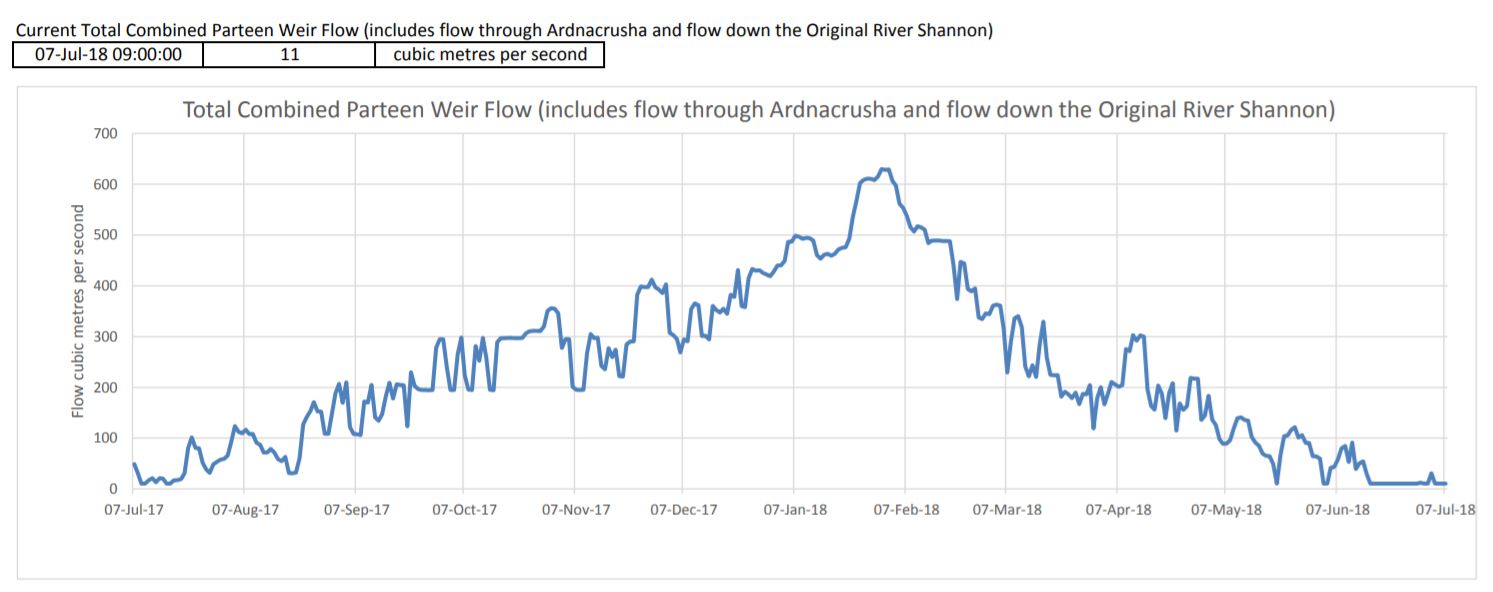
The flow at Parteen Villa Weir
The flow has been pretty well flat, at 0, for some time. The Parteen and Ardnacrusha charts have accompanying tables giving the figures for the last 30 days; here are those for Ardnacrusha:
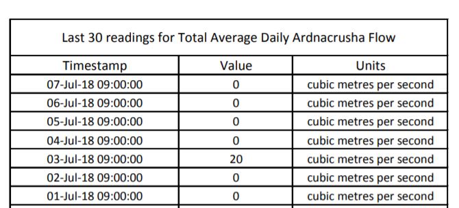
The flow at Ardnacrusha
Each of Ardnacrusha’s four turbines uses about 100 cubic metres per second [cumec]. The flow through Parteen Villa Weir is divided between the old course of the Shannon [which must get 10 cumec] and the new channel through Ardnacrusha. The combined flow through Parteen has been 11 cumec for the past week, and Ardnacrusha has been getting nothing (except a tiny amount on 3 July). That explains why the level of water at Castleconnell, on the old course, is slightly higher than normal summer levels (11 rather than 10 cumec).
And with no water going through Ardnacrusha, the level of Lough Derg is normal (see the chart for Killaloe) and there is no strong current at Killaloe.
Note, by the way, that the levels shown by the ESB are referenced to the older Poolbeg ordnance datum, not the Malin Head used since 1970: “Poolbeg OD was about 2.7 metres lower than Malin OD.”
Other sites?
If, Gentle Reader, you know of any other accessible web pages with user-friendly information on flows or depths on the waterways, do please leave a Comment below.
Posted in Ashore, Built heritage, Canals, Drainage, Economic activities, Engineering and construction, Extant waterways, Industrial heritage, Ireland, Operations, Shannon, Uncategorized, waterways, Waterways management, Weather
Tagged Ardnacrusha, Athlone, Bellantra, ESB, flow, Killaloe, level, Lough Allen, Lough Derg, Lough Ree, OPW, Parteen Villa, Pofrtumna, Shannon, Thatch, Waterways Ireland
The end of the long acre?
Waterways Ireland Marine Notice 2017/133
Shannon Navigation/Removal of objects from the River Shannon
Waterways Ireland wishes to advise masters and owners of vessels that consequent to a recent Health and Safety Audit a number of unsafe jetties, ancillary walkways, practices and services have been identified in the vicinity of the Railway Bridge on the West Bank of the River Shannon (Watergate, Accommodation Road (R446)), on Waterways Ireland property.
As a result of the Health and Safety Audit it has been decided to remove all un-safely moored vessels, dangerous access platforms, walkways, electrical cables and any other fittings deemed to be unsafe.
Works will commence as operationally convenient after 20 December 2017. Removed items may be stored at owner’s expense in accordance with Shannon Navigation Bye-Laws.
Shane Anderson // Assistant Inspector of Navigation // 01 December 2017
=================================================
Two stories from the Westmeath Independent
Posted in Ashore, Built heritage, Economic activities, Engineering and construction, Industrial heritage, Ireland, Irish inland waterways vessels, Modern matters, Operations, Rail, Safety, Shannon, Steamers, Tourism, waterways, Waterways management
Tagged Accommodation Road, Athlone, health and safety, long acre, watergate, Waterways Ireland
That it should come to this …
A blue sleeping bag discarded near Binns Bridge in Drumcondra is the only clue that people once slept there.
On Thursday 2 November, fast and high waters covered the area under the bridge, and the pathway on either side of the canal that used to run under it.
In July this year, Waterways Ireland raised the water level to prevent homeless people from sleeping under the bridge, a spokesperson confirmed.
From a story by Laoise Neylon in the Dublin Inquirer on 8 November 2017. Well done to Ms Neylon for going and finding out stuff rather than just recycling press releases.
Here’s a map of the areas of the Grand Canal where eviction notices were served [PDF].
There must be some better way of responding to homelessness than by flooding people out.
Posted in Ashore, Canals, Extant waterways, Ireland, Modern matters, Operations, People, Politics, Safety, waterways, Waterways management
Tagged Grand Canal, homeless, Royal Canal, Waterways Ireland
