By comparison with the Grand Canal, which had about fourteen feeders supplying the main line, the Royal seems to be almost a desert: I have found only five supplies. That may be because less has been published about its water supply, which receives comparatively little attention in either Peter Clarke’s The Royal Canal: the complete story (Elo Publications, Dublin 1992) or Ruth Delany and Ian Bath Ireland’s Royal Canal 1789–2009 (Lilliput Press, Dublin 2010). Furthermore, I have no map equivalent to that which I used for the Grand Canal, which was useful in naming the feeders.
Most attention has focused on the Lough Owel feeder, which supplies the summit level, but it was not (and is not) the only source of water. Here is a list assembled from personal observation and from the OSI maps of ~1840 and ~1900, the Guide to the Royal Canal of Ireland (compiled by Ruth Delany and Ian Bath and published by the Office of Public Works in 1994) and some information from Waterways Ireland.
The OSI surveyors working along the Royal seem to have been less interested in canal feeders, or perhaps there just weren’t as many. In several places they seem to have marked feeders with the letters CS rather than the words Canal Supply, making them rather harder to spot. As a result, I am not confident that this list is comprehensive and I would welcome additions, corrections and clarifications; please leave a Comment below.
Again, the list goes from east (Dublin) to west (the Shannon).

Ryewater supply, entering from the north just below 17th (Ferns, Ferrans) lock, west of Kilcock (OSI ~1900). There is a distortion in the online map at that point, but I assume that the sluice shown controlled discharge into the canal

Riverstown supply, entering from the north opposite the harbour at Thomastown

Pig’s Nostril, about half way between Baltrasna Bridge and Saunders Bridge east of Mullingar (OSI ~1900). This is a guess at the location, but it seems the most likely candidate; confirmation or contradiction welcome
")
Lough Owel Feeder (upstream end)
There is more about the Lough Owel Feeder here.

Ballynacargy harbour supply (which may be the Balroe supply: Balroe Bridge is at 34th lock, one up from Ballynacargy)
Is that all there is? Comments particularly from folk who’ve been along the Royal recently.
Update November 2012
The Inspector’s Report to An Bord Pleanála on the Royal Canal Water Supply Scheme PL 25.JA0030 and PL 25.PW3005 reports that Nigel Russell, WI’s Director of Technical Services, described the “sources of water to the canal”:
Apart from the summit Mr Russell noted that around Enfield there is some natural inflow as the canal is in cutting. There are two small gravity feeders in addition, the Thomastown feeder, a small stream, and the Rye water, which operate in flood weather conditions. The Boyne and Inny have been pumped over the last ten years and in times of low flow have been a significant source of water. In low flow the only Lough Owel derived water is from the fish farm. If it is considered that pristine Lough Owel water is the main source of water to the canal that is not accurate. Lough Owel supplies the canal during high water levels. At low flow times the canal sources are pumped water from the Boyne and Inny, Lough Owel water and Cullion fish farm recirculated water. […] Mr Russell indicated that the relative contributions of water at times of low flow could not be estimated. Losses of water through seepage is being addressed and illegal abstractions are being pursued. A large throughput of boats will give rise to large losses.
Update November 2018
Waterways Ireland is still pumping from the Inny into the Royal Canal at the Whitworth Aqueduct, north of Abbeyshrule, but the level is still well below normal.

The inflow from the pump
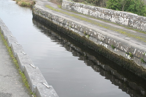
The water level on the aqueduct
The location of the aqueduct
![]()
[RC10]


if memory serves me correct, there is a drain into the Royal just east of the 13th Lock at Blakestown. In Glasgow currently so can’t check on the ground.
Thanks, Ewan. Nothing shown on the old OSIs, but I’m not sure that means very much! If you can check at some stage, that would be useful. bjg
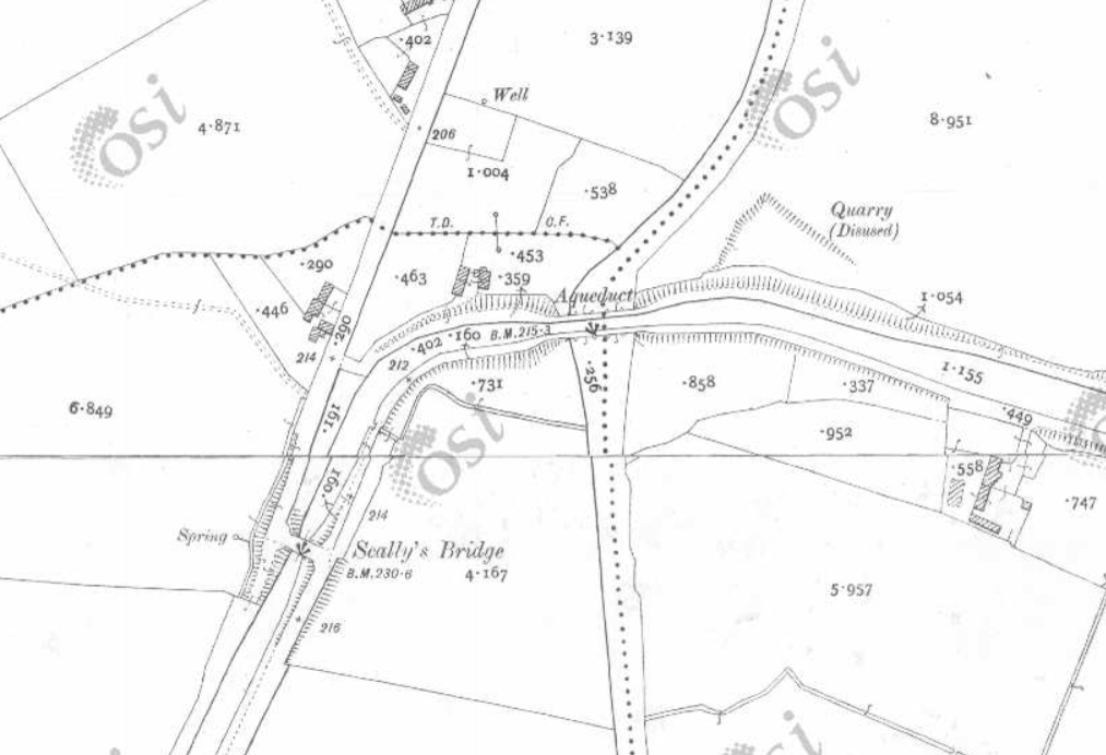
Update: memo to self: maps show things in two dimensions but in real life there are three. What I thought might be a supply from the Inny at Scally’s Bridge must instead be an overflow, as the canal is above the river at that point, having just crossed it on an aqueduct! Accordingly, I have deleted that from my list.
Brian – apologies for the delay in responding. Drove by the 13th Lock this morning and there is a drain feeding to the canal – it is possible that it is runoff from the railway line. WIll send the photo to you by email.
I walked the Royal in May and noted at least 3 pumped feeders, of which i photographed 2 (emailed). Of these, one was just past the McNead’s Bridge but before the lifting bridge. The second was at the Inny Aqueduct at Abbeyshrule.
Brilliant; thanks Martin. How was the walk? I remember some years ago, going by boat, some sections of the towpath were pretty rough, but I haven’t seen all of it in recent years. bjg
We were blessed wih 5 sunny days, thanks to which my memories of summer 2012 are good. The Grand is logistically easier ( 4 x c30km sections) but the scenery on the Royal is superior. No major or even minor
obstacles en-route, I am looking forward to Minister Varadker’s plans to develop it further for cyclist and walkers. (Because there sure ain’t enough boats using it).
Thanks, Martin. How did you arrange the sunny days? bjg
Growing up beside the canal in Enfield I can tell you there is a stream feeding the canal between Enfield railway station Bridge and Cloncurry Bridge.
Great: thanks for that information. bjg
Just happened on this site whilst home on holidays last year and walking the canal at Killashee
Very informative and especially love the very local aspects of the updates
Thank you. bjg
The arterial drainage ( river dredging) schemes of the 1950s-1970s have taken a few meters off a lot of water tables along the canal, and particularly the Boyne itself. So a lot of feeder streams no longer work for much of the year. You need a really wet summer to provide water for the locks.
I understand that the extraction pump from the Boyne is not licenced and that it may be decommissioned. Licenced by what of our myriad quangos I cannot say , could be anyone from the EPA to Waterways Ireland to the NPWS or all of the feckers.
Thank you. That is very interesting and informative. The implications of drainage had not struck me. bjg
I’m not sure if the Rivertown supply, entering the harbour at Thomastown is actually entering the canal it seems to be getting piped under the canal at this point, the water seems to drop into a grate and there is no output flow into the canal also, the wall at this point has been undercut and collapsed and is just a shallow area in the harbour now. I understand some “explorers traced the river and found unrestored sluice gates similar to those being used on the lough Owel feeder. So even though this river is flowing I do not think it is entering the canal
Thanks, Ben. You’re right about the sluice: on map.geohive.ie enter the coordinates 657910.769,750856.452 and you should land at the top of the feeder, which is itself fed by the Riverstown River. Under Data Catalogue, Base Information and Mapping, switch to Historic 25″ and you’ll see the sluice marked. Follow it down and you come to a T junction with another sluice. After that it gets a bit complicated: two branches head towards the canal, the one to the left being marked “CS”. Both of them seem to go under the canal but the right-hand one looks as if it has an outlet (a small arch) in the canal as well, and maybe that’s marking the blocked outlet. bjg
Pingback: Garryowen and the Royal Canal | Irish waterways history
http://webgis.buildingsofireland.ie/HistoricEnvironment/?REG_NO=15402732
Brian,
On the above link you can see the unrestored sluice which would have supplied water from the Riverstown River, north of Thomastown, to the Royal Canal at Thomastown Harbour. There is still a small feed entering the harbour but I believe in pastimes when the sluice was operational the supply in wetter weather would have been considerably more substantial. This would have greatly improved conditions on Long Level which suffers regularly now with low and fluctuating levels.
The sluice appears to be complete but needs restoration. W.I. state that issues with landowners through whose land the feeder runs prevents restoration, I believe it’s probably more an issue of economics.
By the sluice in the Riverstown River there appears to be a weir-like stone which would have only allowed water to reach the sluice if when the water level rose to a certain height. This stone is now moved some 90 degrees out of position and may have been used as a stepping stone stepoing to cross the river when low.
It is ironic that the water from the Riverstown River eventually flows into the Boyne where it is then pumped at some cost by W.I. up into the canal at the Boyne Aqueduct…. on Long Level!
It’s mad Ted!!
Thanks, Denis: that’s very useful. I hadn’t realised that NIAH material was now on GIS.
I don’t suppose there’s any progress with Lough Ennell.
bjg
There is a curious aspect of this. The River Brosna is said to begin at Lough Owel, but I can’t find any outlet except for the feeder. Looking at aerial photos, it seems that it splits from the feeder at the fish farm location.
So it may be that the feeder uses the outlet that was originally the river, then it diverts, straightened out towards the canal.
I’ve looked at the OSI historic maps http://map.geohive.ie/mapviewer.html and it seems to have been the same back in the 1830s (or whenever that bit was surveyed). There was a tannery near the junction back then, a bit upstream of where the fish farm is; then, on the 25″ map of around 1900, Culleenmore House seems to be on the tannery site. In all cases, the river seems to start from around there, branching off from the feeder.
bjg
Brian,
Regarding Lough Ennel and the possibility of a replacement suppky to the Royal, in discussion with W.I. engineering early this year I learned that the Ennel plan may yet be revived. Issues with water rights, which had previously scuppered the plan, had been resolved by W.I. It remained for engineers from Irish Water and W.I. to review the plan.
Irish Water had stopped water from Lough Owel entering the feeder on Jan 31st as the Lough had not fully recovered following the previous dry year. However, this summer having been so wet, the Lough is well up and supply to the Lough Owel feeder has been restored, temporarily anyway.
Thank you for that. bjg
Would anyone know, if the Lough Owel supply intake is incorporated into the source of the River Brosna?