This page was originally headed The Broharris Canal. It has been considerably revised [on 12 October 2017] but mysteries remain. If, Gentle Reader, you can help to elucidate them, do please leave a Comment below.
Some minor further revisions, mostly about NI maps, have been made on 13 October 2017.
The Broharris canal
In her Ireland’s Inland Waterways: Celebrating 300 years [Appletree Press, Belfast 2004], Ruth Delany devotes a paragraph to the Broharris Canal, a two-mile long cut near Ballykelly on the south shore of Lough Foyle. It was said to have acted as a drainage channel and to have carried in goods from Londonderry and sea manures (shells and seaweed for use as fertilisers), which W A McCutcheon, in The Canals of the North of Ireland [David & Charles, Dawlish 1965], says came from
… the banks exposed at low tide along the shallow, shelving coastline stretching westward from Magilligan Point.
The canal was built, the two authors agree, in the 1820s; McCutcheon says that it cost about £4500 and that it was not mentioned in the Railway Commissioners’ report in 1838.
I could find no photos, paintings or drawings of the Broharris Canal on tinterweb, and I have none myself. Furthermore, on the 6″ OSI map, I could find no canal at Broharris itself (it’s slightly to the east of the area shown below) but I did find something called the Ballykelly Canal.
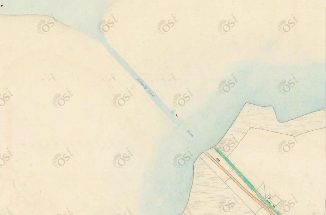
The Ballykelly Canal

Ballykelly Canal (OSI 6″)
Note that there is a basin at the inland end of the canal.
The interesting thing is that the canal is not cut through the land: it is dug through the banks that McCutcheon mentions. I guess, therefore, that it would have been underwater at high tide.
An orange line runs to the shore inland of the basin; it seems to be a road. Roughly parallel to it is a green line; at the Ballykelly end, that is marked “Ballykelly River”, but it seems very small: perhaps too small to be navigable.
And could the canal have changed from being underwater to being underground? If you go to the OSI map here, select the Historic 6″ and put the scale at 1:10000, the Overlay slider (at the bottom of the panel headed PREVIEW MAP SERIES) will work, allowing you to show the current coastline on top of the old. [I found that, perhaps because access to the NI mapping is limited for freestaters, the slider did not work at all scales.] If the overlay is working properly, it looks as if most of the canal, including the basin, is now under reclaimed land along the shore.
A digression on maps
Ordnance Survey Ireland [OSI] very kindly makes available online, free to view, both the 6″ Ordnance Survey map, various sheets of which were published between 1833 and 1846, and the 25″ map, produced around the end of the nineteenth century. It also offers a modern street/road map and several “ortho” maps based on aerial photos (I imagine).
The two historic surveys were conducted while an undivided Ireland was a constituent of the United Kingdom of Great Britain and Ireland and, happily, the OSI 6″ online maps show the whole of the island. However, although the same political conditions applied when the 25″ map was made, the OSI online version stops at the border with Northern Ireland for any scale larger than 1:10000. Furthermore, the same applies to the modern street/road map.
I presume that this is by agreement with Ordnance Survey of Northern Ireland [OSNI]. For modern matters, we can use Google (or something similar) for close-ups of places across the EU’s border-to-be. OSNI did not (as far as I could see) publish any historic maps online. However, Ewan Duffy has drawn my attention to OSNI’s Map Shop, where it is possible to look at several different versions of various historic OSI maps.
The interface is clunkier than OSI’s: as far as I can see, you have to go back to the Historical Products page to change to a different edition of the map, and you have to give it a place name to start with; it then offers a choice of modern placenames that would have meant nothing in 1830. I just searched for [town or village] Ballykelly and took the first address offered, then moved around from there. Entering Broharris as a town or village also worked.
On the OSI maps, moving the slider up zooms out; on the OSNI, it zooms in. No wonder Norn Iron wants to head for a glorious future of free trade without being encumbered by non-WASP Europeans.
Once you get to a map, though, an overlay tells you what sheet it is and gives a date or a range of dates, which is useful, though I don’t know whether they show when the area was surveyed or when the map was published.
On the OSNI system, unlike the OSI, it does not seem to be possible to provide a link that takes you straight to the proper place on the proper map or edition: a link can take you only to the edition, and you have to search for the place you want.
Steve Bradley’s article [October 2017]
In October 2017 Steve Bradley wrote an article in the Derry Journal called “Time to regenerate the Foyle’s forgotten canals”. I disagreed with his proposal that the Strabane Sheugh be made navigable, but I read with interest his description of the Broharris Canal:
The other canal constructed on the Foyle was at Broharris near Ballykelly. It opened in the 1820s and served as both a drainage channel and a navigation route. It ran for only two miles – from Ballymacran Point on the shore of Lough Foyle southwards in the direction of Limavady. Its primary importance lay in transporting large quantities of the shellfish and kelp collected along the shallow coastline up to Magilligan Point, which was used extensively as fertiliser on the sandy soil around Benevenagh.
When I first wrote this page, I was unable to find anything on the 6″ OSI map called Broharris Canal. The nearest I could find was the Ballykelly Canal shown on the map above, and I wondered whether that might be the same thing. However, Steve Bradley’s article convinced me that that was not so: the Ballykelly and Broharris canals are (or were) two separate canals. That, incidentally, brings to four the number of canals I know of around the Foyle (the Strabane and the Willsborough being the other two).
More on the Ballykelly Canal

Walworth and the Ballykelly Canal (OSI 6″)
I looked for information on the British Newspaper Archive. In April 1827 one Arthur Sampson of Walworth, near Newtonlimavady, advertised for sale …
A large quantity of remarkably fine oak, beech, fir, ash, and other Timber, the property of The Worshipful Company of Fishmongers,
… which had been cut down and was ready for sale at Walworth, from which …
It may be transported by water from any sea-port, from Ballykelly Canal.
Belfast Commercial Chronicle 2 April 1827
In November of the same year he advertised a house to be let in the village of Ballykelly “half a mile from the Canal” [Belfast Commercial Chronicle 5 November 1827]. In 1832 two brothers, who had been collecting shells in their boat “a little above the canal of Ballykelly, in Lough Foyle”, were found drowned [The Northern Whig 25 October 1832] and four more men drowned in 1835, with one of the bodies, “in such a putrified state that it could not be identified”, “found in the canal near to Ballykelly” [Derry Journal 9 June 1835].
Looking at the Google view of the area, it seems that there is nowadays a watercourse running from the sea into Ballykelly, alongside Station Road for most of the way.
Ballykelly and canal (Imagery (c) 2017 DigitalGlobe, TerraMetrics, map data (c) 2017 Google)
Was that watercourse always there? Or was it added after the OSI 6″ map was surveyed? That map …
Ballykelly Canal: all at sea? (OSI 6″)
… applies the name Ballykelly Canal only to the watercourse through the dunes. But it is possible that the green line stretching inland from the coast is the continuation of the canal, even though it is not labelled as such. Closer to the town, it is labelled Ballykelly River, so perhaps what we have here is a river that has been somewhat improved to make its lower reaches navigable for small craft from the town to the shore of the Foyle, with a canal dug through the dunes to perfect the navigation.
The OSNI 6″ Second Edition is not much more helpful. It says it’s showing Londonderry Sheet 9 1848–1852, when some land has been reclaimed and the railway has been built. The name Ballykelly Canal appears on the seaward side of the railway, but that might be the section through the dunes. The section inland of the railway has nothing to suggest that it was part of a navigation.
What about the broharris?
It is clear, then, that there was a Ballykelly Canal, near Walworth. But it also seems clear that the Ballykelly Canal was not the Broharris Canal.
Steve Bradley tells us that the Broharris ran inland for two miles from Ballymacran Point. Ballymacran is here, a small setttlement, but with nothing that looks like a point. Ballymacran also seems to be considerably further inland than it was at the time of the 6″ OSI map. And, while I can find several references to Ballymacran elsewhere on tinterweb, I can’t Ballymacran Point anywhere, except in the context of the Broharris Canal, as with the Northern Scrivener here.
It seems possible, then, that Ballymacran Point is no more: that it was lost in the land reclamation along the Foyle in the nineteenth century, swallowed up like Islandavanna on the Fergus. But, on the 6″ OSI map, this might be Ballymacran Point. If, Gentle Reader, you can confirm or disprove that, please leave a Comment below.
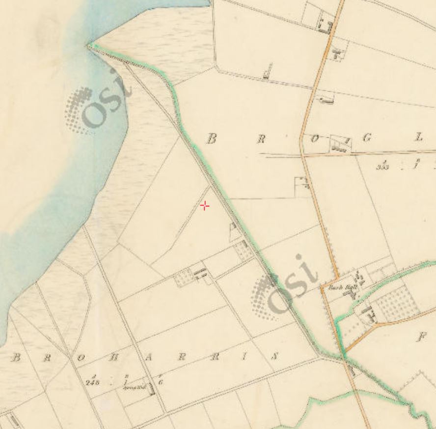
Townland of Broharris (OSI 6″)
If that is indeed Ballymacran Point, then the double dotted line, outlined in green, might be the Broharris Canal: it passes along the north-eastern border of the townland. Note that Rush Hall is to the east of the line and see where it is on the Google view below.
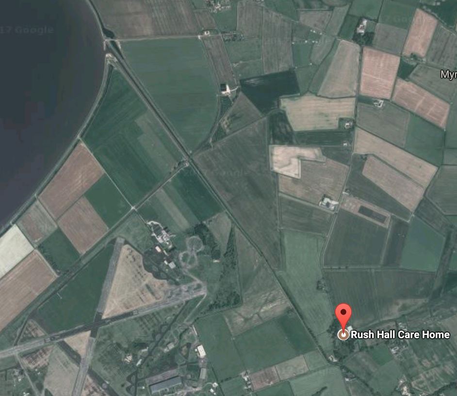
Rush Hall (Imagery (c) 2017 DigitalGlobe, TerraMetrics, map data (c) 2017 Google)
In the second version below, I think that the area circled in red is where the canal met the sea before the land reclamation: in other words, that it is (or was) Ballymacran Point. I stress again, though, that I don’t know the area and I would welcome comment from anyone who does.

Possible location of Ballymacran Point (Imagery (c) 2017 DigitalGlobe, TerraMetrics, map data (c) 2017 Google)
I have found very little in the British Newspaper Archive about the Broharris Canal. I searched for CANAL + each of these terms: Broharris, Limavady, Newtonlimavady, Newtownlimavady, Nnlimavady. The last three versions of the name were all in use in the 1820s. The only useful piece I found was this:
We understand that an application is to be made in the ensuing Session of Parliament for leave to bring in a bill for making a Canal, to be called the Newtonlimavady Canal, to extend from that town to Lough Foyle.
Belfast Commercial Chronicle 10 November 1827
A pamphlet published in London/Derry in 1827, called Hints towards the formation of an extensive line of conveyance, in the North-West District, addressed to the Members of the North-West of Ireland Society, is said to cover proposals for the Broharris [Ballymacran to Newtown Limavady] Canal as well as for canals from the Foyle to the Erne, to Lough Swilly and to Raphoe.
Ballymacran features in several places on tinterweb. It seems that the reclaimed land is protected by two embankments, the Ballykelly and the Ballymacran, which are now walking routes. One interesting point is that, given the extent of land reclaimed, both the Ballykelly and the Broharris Canals must have been lengthened to enable them to continue to reach the sea. It would be interesting to know what other work was done and to what extent the canals were adapted for drainage. Perhaps The Honourable The Irish Society has relevant material in its archives.
The OSNI Londonderry Sheet 9 (1830) is the same as the OSI version. The Series 2 map, Sheet 9 1848–1852, shows the canal with walls sheltering its entrance fr0m the Foyle (but no bridge to cross from one embankment to the next). The word Canal appears (but not Broharris); the canal looks as if it’s on an embankment, which would suggest that the land is lower than the sea. There’s a wide (passing?) place to seaward of the railway line, which crosses the canal on a wooden bridge. But, inland of the railway, the canal soon narrows and, after a slight change of direction, becomes the Burnfoot River.
The story so far
We have, it seems, two short canals, the Ballykelly and the Broharris, quite close together, both running into the Foyle. I guess that both were lengthened in the nineteenth century when land was reclaimed from the Foyle. But I have found very little information about either canal, and especially little about the Broharris. It may be that I am using the wrong search terms.
A further digression on maps
Why would the Ordnance Survey 6″ map have omitted to mark two canals? Admittedly they were short canals, but the Willsborough canal system wasn’t very large either.
One interesting point is that the base for the whole of the Ordnance Survey of Ireland was here, on the flat lands east of Lough Foyle:
… Colby himself had become preoccupied with the most important part of the triangulation, the measurement of a base. … In 1824 he had settled on the eastern shore of Lough Foyle, a site that was flat, close to the sea both horizontally and vertically, and far enough north to be quickly incorporated into a triangulation proceeding across from Scotland. These advantages compensated for the only serious obstacle, the 450-foot-wide estuary of the River Roe, which was in any case surmounted without mishap when the time came.
J H Andrews A Paper Landscape: the Ordnance Survey in nineteenth-century Ireland second edition Four Courts Press, Dublin 2002
If you follow the road to the east from Ballykelly, passing the gravel pit and the church on the left, and look to the right after Drummond, you’ll see South 92 Base Tower in a field: it might have been used for the triangulation.
If I understand Andrews correctly, London/Derry was the first county to be projected. Andrews says that, until July 1827, there were “no positive instructions for joining up roads and streams that crossed from one parish to the next”; perhaps there was also a problem with watercourses that ran along parish boundaries. In 1830 Richard Griffith, in charge of delimiting and valuing townlands, had his valuators begin to use the 6″ maps in London/Derry. They found that houses had been omitted or misplaced and that “small buildings, minor roads, and the limit of cultivation had simply been disregarded”. In [at least] one district the “survey of by-roads, streams, and so on” had been neglected.
Colby, in charge of the Ordnance Survey, had to have the London/Derry plans revised.
The interior features, omitted as many of them were from the content field books, presented a different and more difficult problem. It frequently proved impracticable to correct the old plans or … to replot the original books; and if it was practicable, revision often turned out to be more expensive than a completely new survey. [Andrews op cit]
Revised maps of London/Derry were published in 1833, a “striking improvement” (says Andrews) on the 1827–30 maps, but with “still a few signs … that the survey had not quite reached maturity”.
Not being a geographer, I don’t fully understand Andrews’s comments, but it does seem that there may have been problems with the 6″ OSI maps of London/Derry, because it was the first county to be completed: problems that might not have been found on later surveys.
It is possible that the Broharris Canal was not completed when the county was surveyed, but the inland Ballykelly should have been shown. In this, as in so much else on this topic, I will be glad to hear from anyone better informed than I am.
![]()
![]()
[ulster96]


Only a few Km from where the Broighter boat of about 2,000 years ago was found. http://irisharchaeology.ie/2012/09/the-broighter-hoard/
http://www.londonderrysentinel.co.uk/news/the-broighter-gold-is-not-from-limavady-1-5665098
Antoin
Indeed.
You can have a replica of the boat made in silver https://www.facebook.com/media/set/?set=a.1343200002412620.1073741845.404330912966205&type=3
bjg