The first attempt at improving the navigation through Banagher, on the River Shannon, was the construction, by Thomas Omer, of a canal along the west bank of the river. This mid-eighteenth-century scheme, with just one set of gates despite a three-foot fall (Ruth Delany The Shannon Navigation Lilliput Press 2008), was not very successful, but it did leave us with a characteristic Omer lockhouse and some other remains.

The Omer lockhouse, Banagher
But Banagher had a second canal. The next photo is taken from the bridge in Banagher, on a wet day. The harbour is to the right; on the left you can see the pontoons of the hire firms. If you look upstream of the harbour …

Banagher’s lost canal
… you won’t see any trace of the canal. Nor will you see any trace of the railway station, although aerial photographs clearly show the line of the former railway itself. Banagher was the terminus of a branch line, from Clara Co Offaly, of the Great Southern & Western Railway; the railway station was roughly where the hire-boat companies now have their bases.
According to Valentine Trodd, in Banagher on the Shannon: a historical guide to the town with illustrations by the author (1985), Anthony Mackey of Castleconnell, Co Limerick, had eel-fishing rights. Mackey also owned eel-weirs in Castleconnell; there is an account of his operaration in Joe Carroll and Pat Tuohy’s Village by Shannon: the story of Castleconnell and its hinterland (1991).
At Banagher, Valentine Trodd tells us, eels were kept in tanks along the river-bank until spring, then boxed and taken up a small canal, called the old boat drain, to a siding at the railway station. Such a canal is shown on the Ordnance Survey map, surveyed in 1909 and published in 1911. There is no trace of it now. If anyone knows of a photograph of the canal, I would like to see it.
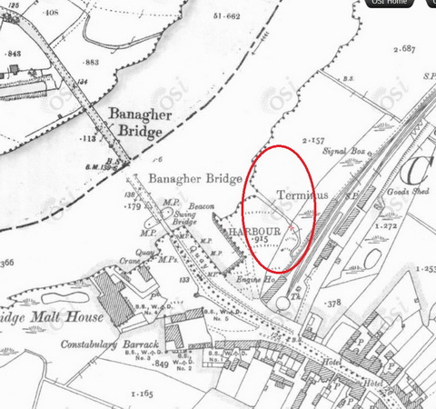
The eel canal?
![]()
Incidentally, this is one of the few instances of the use of the term boat drain that I have found. I discussed it on my page about the Little Brosna:
Further upstream, opposite Tinnakilly and in what appears to be a bog, the OS map shows a channel bearing the legend “Boat drain”. That term is used in other places on the OS maps; a recent Lough Neagh website also uses it for what is otherwise called a cove: a small cutting in which boats are kept afloat. (I would be grateful for a formal definition of a boat drain, if anyone can supply such a thing.)
I would welcome information about any other uses of the term.
[lk2atr60]


Pingback: Anguilla anguilla: the ESB eel fishery « Irish waterways history
Pingback: The stolen railway | Irish waterways history