Jacques-Louis de Bougrenet de la Tocnaye wrote in 1797:
The Shannon is not navigable, properly speaking, above Limerick; its course is thereafter often interrupted by rocks and cascades through which a plank could hardly pass in safety. To make navigation possible there have been cut, lately, certain canals making connection between those parts of the river which are deep enough for boats. One of these canals, a mile long, ends at Limerick, and in its short course there is a fall of not less than thirty feet. Boats can only ascend, by the locks, at a suitable time of tide, which here rises or falls from twelve to fifteen feet, although the town is sixty miles from the mouth of the river. One or two miles higher up, there is another canal, newly-finished, joining the river seven or eight miles from Castle Connell […].
If you examine the online Ordnance Survey Historic 6″ map for the Plassey area of Limerick, you’ll notice an oddity. Here’s the relevant bit.

Plassey ~1840
You’ll see that there is a ferry from the north bank to the middle of the river and what looks like a bridge from the south bank almost, but not quite, meeting it.
The later (Historic 25″) map, from around 1900, shows the bridge stretching all the way across.

Plassey ~1900
I refer to these two editions as the ~1840 and ~1900 editions, but of course different areas were surveyed, and the maps printed, at different times over the course of several years. The north bank at Plassey, which is in Co Clare, was surveyed before the south, which is in Co Limerick, and the bridge was built in the interval.
Plassey is now the site of the University of Limerick, part of the suburb of Castletroy. It is the junction between two of the five sections of the (now-abandoned) Limerick Navigation, which connected Limerick and the sea to Lough Derg and thence to Dublin. The next map shows, at bottom left, the Park Canal from Limerick; from its upper (right-hand, on the map) end the navigation passed into the River Shannon, which curved south and north in a large S. Then, around the centre of the map, you can see the straight line of the third section of the navigation, the Plassey–Errina Canal, heading north-eastward away from the river. It avoided the Falls of Doonass and rejoined the river downstream of O’Briensbridge and upstream of Castleconnell.

Two junctions on the Limerick Navigation
Before the bridge
Downstream of Plassey, the boatstream and the trackway (towing-path) are on the south (left-when-facing-downstream) bank of the river, but the Plassey–Errina Canal departs from the north bank. So a boat travelling from Limerick to Killaloe, at the southern end of Lough Derg, had to cross the Shannon, while the force of the current tried to sweep it downstream.
In the days before engines, boatmen had nothing but muscle power and ingenuity to help them across. It was probably difficult enough when the water level and current were low, but practically impossible when they were high.
Although the Limerick Navigation Company was set up in 1767, the first traffic was not until 1799, and that was only ten boats, carrying 15–20 tons each of non-urgent cargoes including corn, slate and turf. No towing-path was provided at first; boats were man-hauled on the Park Canal (as it is now called) and sailed, rowed or poled on the river sections.
The difficulty of crossing the Shannon at Plassey was recognised. It seems that John Brownrigg, engineer to the Directors-General of Inland Navigation, had considered laying a chain across the river so that crews could haul their boats over; Francis Trench, in a report in 1805, did not consider this a satisfactory solution, but he did praise Brownrigg for having turned the course of the River Blackwater (which joins the Shannon alongside the Plassey–Errina Canal) so that it no longer created shoals at the entrance to the canal. (On the next map, you can see the Blackwater parallel to the canal.)
The OSI map of ~1840 shows some buoys in the river; they may have been used in getting boats across the river.

Buoys
A towing-path was eventually built on an embankment along the river sections, but it was not entirely satisfactory. In evidence to the Select Committee on the Shannon Navigation on 14 July 1834, Charles Wye Williams said:
[…] it is so high and narrow that the horses often fall off it. […] It is [subject to inundation], so much so that there is often a sea upon both sides of the high-raised bank, and during last winter a large portion of it was swept away; the whole bank was covered with three feet of water, so that we were obliged to send men with sticks leading the horses, and feeling their way on the banks. […] There is no way of improving it. […] It could be widened, but at great expense.
Boats, passengers and horses had to be transferred from one side of the river to the other. It might have been possible to use different horses on the far side, avoiding the need to ship them across, but the Parliamentary Gazetteer of 1846 suggests that they were transported:
PLASSEY, a locality in the parish of Kiltonanlea, barony of Lower Tulla, co. Clare, 2 miles north-east of Limerick, Munster. Here the rivulet Blackwater falls into the Shannon, the long stretch of the Limerick navigation within Clare commences, and a foot bridge across the Shannon was proposed to be constructed by the Commissioners for improving the Shannon Navigation. The horses employed in tracking boats up the Limerick navigation pass at Plassey from the left to the right bank of the Shannon, and used formerly to be conveyed across in boats, a method occasioning both inconvenience and delay; and the chief design of the foot bridge is to afford for the horses facility of passage. Estimated cost, £3,000.
Thomas Rhodes, surveying the Limerick Navigation for the first set of Shannon Commissioners in 1832, wrote of Plassey:
Great inconvenience is felt from the want of a foot-bridge to cross from Plassey Mill to Annaghbeg Lock, for the purpose of towing the packet-boats and trading vessels: at present a ferry-boat is employed for the purpose of taking horses and passengers across the river. The velocity of the current at this place has been ascertained this winter, and found to run at the rate of three miles per hour; width of river, 450 feet. Passengers have been obliged frequently to get out of the packet-boat, and be ferried across in the small boat; and trading vessels have been cast ashore on the bank below, and under the necessity of unloading the cargo into other craft for the purpose of getting off; this is highly dangerous to lives and property. At present a buoy is anchored in the centre of the river, and in times of a flood trading vessels are obliged to run out a cable or warp to this buoy to swing clear of the north bank; and when this is accomplished, they run another warp to the south side to haul them across: this method causes great delay.
I am credibly informed that foot passengers alone, who are in the habit of crossing here, would pay the interest of a bridge; but for the improvement of the navigation alone, I consider a bridge absolutely necessary, and therefore I have now a plan and estimate in preparation for it.
This suggests that a ferry boat was kept at Plassey for passengers. In 1815 Patrick Curtis, at Ferry House, Plassy, earned a half-year salary of £7/10/=.
It is not clear how trading vessels would run a cable to a buoy during a flood; it would make more sense to have the cable permanently attached and to use the force of the current to swing the boat across the river. Kevin Hannan [PDF] says that winches were used. I will continue to seek evidence and would welcome further information.

Is this the ferryman’s cottage?
Thomas Rhodes’s bridge
The second set of Shannon Commissioners drew up plans for the various works. Rhodes designed the bridge to be erected at Plassey. Here are two poor photographs of parts of the plans.

The design of the bridge

The location of the bridge
Incidentally, the mill had its own lock: not on the Shannon but on its mill race. I presume they allowed the mill’s barges to moor out of the way of boats going up and down stream. Perhaps using two sets of gates meant that a barge could be kept at a height convenient for loading and unloading, no matter what level the Shannon and the mill race were at. However, that’s speculation: I have seen no evidence on the matter.
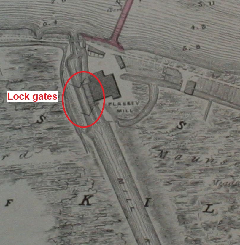
Plassey mill lock
The third set of Shannon Commissioners carried out the work. In their third report, for 1841, they wrote:
Plassey Bridge
This work is considerably advanced; the excavations for the abutments have been completed, and all the bearing piles driven, together with the cappings fixed on them ready to receive the masonry; the filling in of the concrete between the piles has also been completed.

Looking across the bridge towards Plassey Mill
All the main piles for supporting the girders, plates for the roadway, &c, have been driven, and the timber and iron cappings fixed on them.
The whole of the iron work, consisting of girders, fascia and roadway plates, &c, has been delivered on the works, ready to be fixed; consequently this bridge will be completed within a short time.
The average number of persons employed daily upon this work, from its commencement on the 3rd May up to the 31st December 1841, was 12, being equivalent to 2,461 days’ work.

The bridge from water level

Ironwork 1

Ironwork 2

Ironwork 3

Ironwork 4

Ironwork 5
The following year, in their fourth report, the Commissioners wrote:
Plassey Bridge
This bridge has been completed, and independent of the advantages which it affords to the traders for passing horses employed in towing the boats, the public have been allowed to use it, instead of being ferried over in a barge as formerly; it is now much used by the country people who attend the markets in Limerick, or who have business to transact there.

Stonework
By a Return furnished to the Commissioners, it appears that between the 20th and 27th December 4,161 passengers and 76 horses have crossed over this bridge.
The average number of persons employed daily at Plassey Bridge, from the 25th April to the 17th September, was 27, being equivalent to 3,362 days’ work.

The completed bridge
In the same report, the Commissioners made an interesting point:
Limerick Navigation
[…] In consequence of the erection of Plassey Bridge, it became necessary to change the trackway from the north to the southern bank of the canal between Annaghbeg Lock and the first bridge above it; this was effected for a trifling expense, and thereby did away with the necessity for having a bridge across the canal below the lock.
That change is reflected on the OSI map from ~1900:

Towing path changes sides at Gillogue
Kevin Hannan wrote:
Trippers to Plassey are often puzzled by the milestone mid-way between the bridge and the garrison wall. This stone bears the inscription: ‘Limerick 2 miles; Killaloe 12 miles’, and up stream from the canal track, people are bewildered by its positlon. This circumstance is a reminder of the days before the erection of Plassey Bridge, when the towing horses were ferried across the river on a special raft which was winched from one side to the other. […] The building of Plassey Bridge saw the end of this difficult, and dangerous operation. The milestones were erected between Limerick and Killaloe, in 1814, and marked the mileage both ways. The distances were set out in Irish miles.

The milestone
I don’t know whether the milestone is in its original position. If it is, it might be possible to work out something about the ferry system by seeing whether an isosceles triangle, with its apex at the position of one of the buoys marked on the ~1840 OSI map, would touch the presumed launching point near the milestone and the northern (downstream) bank of the Plassey–Errina Canal.
The tow-ropes of the barges

High water above the black bridge
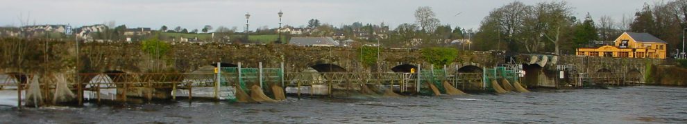
The bridge made it easier for horses to get across the river; it did nothing to reduce the power of the current. Nowadays, most of the Shannon’s flow is diverted through the hydroelectric power station at Ardnacrusha, which gets the first 400 cubic metres per second of water; the old course of the river, through Plassey, gets only 10, unless Ardnacrusha has more than it wants, although it does get extra water from tributaries like the Mulcair. Ardnacrusha has also had the effect of reducing seasonal variation in water level along the old navigation, and it is only in extreme conditions that we get any idea of the amount of water that formerly came through Plassey. Such conditions occurred in November 2009, when the photo above was taken (see more pics of that period here, here and here).

Stonework at the Annaghbeg end

Looking along the wall
The bridge meant that the horse was not subject to the force of the current — but the barge or lumber-boat was. As the horse walked across, the barge was more and more exposed to that force, pushing it downstream; the strain on gear, ropes and horses must have been considerable.
That strain can be felt on the parapet of the bridge: the stonework on the Annaghbeg side bears grooves worn into it by the tow-ropes. The grooves are almost impossible to see (and I wouldn’t have known about them but that An tOllamh Breandán Ó Madagáin told me about them) but you can feel them with your fingers. I put pens in some of the grooves so that they would show up in the photos below.

Pens show some of the grooves

Another view of the grooves
I am told that rope-marks can also be seen on the metal rails of the bridge, but I have no photos of them.
Rope marks on bridge abutments or piers are relatively common; marks on the parapets are rare. I have seen no description of a crossing of the river at this point; it would be interesting to know how horses and their human drivers dealt with the strain.
The floods of 2009
The navigation was abandoned when the Ardnacrusha power station was opened. However, it was still owned by the state (Office of Public Works, as successor to the Shannon Commissioners), and in 1949 Limerick County Council leased it. It made some repairs to the bridge at that time.
Sixty years later, in 2009, Plassey was flooded.

Plassey floods 2009
The black bridge, which usually stands well clear of the water …

Bridge clearance at summer levels
… had water almost up to its deck and debris caught against it.

The bridge during the floods
The County Council feared that the bridge had been weakened; it closed the bridge. It has not been able to afford to repair it properly.

The bridge blocked
The Council can argue that walkers, including those following the Lough Derg Way, can use the University of Limerick’s road bridge just upstream; it has a separated section for walkers and cyclists.

The University’s bridge
Someone walking from Limerick to Gillogue would have to go a little further upstream, to reach the university’s bridge, then back downstream on the far side to reach the Plassey–Errina Canal’s towing-path. It is certainly true, then, that in practical terms the bridge’s closure is not a great inconvenience.
The significance of the bridge
But that is to miss entirely the significance of the bridge. It is not, of course, surprising that it should be missed: as far as I know, there is not a single signboard, plaque or even document that calls attention to the historic importance of this bridge and of the route of which it was part.
The key question is why the government of Her Late Majesty Victoria, by the Grace of God of the United Kingdom of Great Britain and Ireland Queen, spent half a million pounds in the 1840s improving the navigation of the Shannon, including building the bridge at Plassey. There are several aspects to the answer, but one of them is that the work was undertaken to prevent food shortages.
In England.
The work was planned long before the Great Famine, although as it happened much of it was carried out during that catastrophe and, with other Shannon improvements, provided employment and income for many men. But at the planning stage, famine was not foreseen.
At the time, Britain was producing only five sixths of the food it needed. Ireland, on the other hand, was able to produce a surplus, while still feeding its people, because its staple, the potato, was so nutritious. Steam technology provided a means of transporting that surplus to the markets of Liverpool and Manchester and to other ports on Britain’s west coast.
Steamers on the Shannon Estuary carried passengers, but also livestock, up to Limerick. Horse-drawn barges carried cargoes of food (grain, flour, butter, livestock, provisions) onward up the old Limerick Navigation to Killaloe, where steamers took over the tow (and picked up more cargoes) up Lough Derg to Portumna. Smaller steamers towed the barges up to Shannon Harbour, whence they were towed by horse along the Grand Canal to Dublin. There, the cargoes were transhipped into larger steamers and sent to Liverpool and, some of them, on further to Manchester.
The ramshackle, badly-designed, badly-built Limerick Navigation was the link between the west coast of Ireland and the cross-country route to Dublin and thence to Liverpool. Charles Wye Williams took over the navigation in order to improve it and to get his boats through; his name is on Baal’s Bridge in Limerick, which as far as I know is his only public monument. But the government decided to take over and improve the whole of the Shannon and, throughout the 1830s, it carried out surveys and drew up plans which it implemented during the 1840s.
The Black Bridge at Plassey was part of that work. When cargoes were of non-perishable goods (turf, stone, timber, corn, slate), a delay at Plassey, while waiting for water levels to subside, did not very much matter. But once the west coast of Ireland became integrated with the UK economy, the arrival of the regular cargoes of food became much more important, as did the safe and speedy movement of passengers: the navigation became part of the most comfortable route from London to Killarney and elsewhere in the west of Ireland.
The navigation has an extraordinary wealth of transport heritage: seven of the original milestones along the twelve-mile route (an Irish mile is about 1.25 statute miles or 2 km), many of the characteristic accommodation bridges, locks, pins for ropes, the capstan at O’Briensbridge, the marble mill and the Pierhead in Killaloe … all part of a historic trail. It helped to built the Irish livestock trade. It has close links with Liverpool, in particular, not only because the food went there but because five of the first six iron vessels built by Lairds of Birkenhead were built for the Shannon. It is also closely linked with the City of Dublin Steam Packet Company and the P&O Line. And the 1840s improvements came about because Ireland’s greatest ever transport entrepreneur, Charles Wye Williams, had shown what could be done.
It might be hard to justify spending money on the bridge for the convenience of locals of both counties, but this is the centrepiece of what could be a major tourism attraction. The Limerick Navigation should be branded as an industrial heritage walking route, not just as an anodyne “Lough Derg Way”, and should be marketed as the focus of weekend and week-long visits to the area. The bridge is the vital link between the Limerick and Clare parts of the navigation.

Reopen it
There are some more reminiscences of Plassey here; googling will find more.
Sources
Charlotte Murphy “The Limerick Navigation Company, 1697–1836” in North Munster Antiquarian Journal Vol XXII Thomond Archaeological Society 1980
Jacques-Louis de Bougrenet de la Tocnaye A Frenchman’s Walk through Ireland 1796–7 (translated by John Stevenson), McCaw, Stevenson & Orr Ltd The Linenhall Press, Belfast and Hodges Figgis & Co Ltd Dublin 1917
The Parliamentary Gazetteer of Ireland […] 1844–45 A Fullarton & Co, Dublin, London and Edinburgh 1846
Kevin Hannan “Memories of the old canal” in Old Limerick Journal Vol 7 Summer 1981
Thomas Rhodes Report upon Canal and River Navigation from Limerick to Killaloe 28 February 1832
Various reports of the Shannon Commissioners
Changes
Some minor amendments November 2018
![]()
plas10


This beautiful bridge needs TLC (Tender Loving Care ) at the moment , since the floods the Black Bridge has been closed , this is such a shame as it has been used over the years by fishermen , walkers , joggers, cyclist , teenagers and students jumping off it and going for a swim on a hot summers day, It is so sad to see it as it is..I have contacted numerous people in the last two years but no one seems to have an answer . This Bridge which is part of our history and who we are should be fixed as soon as possible ,the longer it’s left to the elements , the more damage is being done . Please can we do something to reopen this Gem. Ann Kirby Nolan.
Agreed. If anyone is organising anything, I’ll be happy to publicise it. bjg
why not get a preservation order on it,at least it cannot be dismantled in the meantime.at this stage it could be called the “RUSTY BRIDGE” PLASSEY MILL IS NOW A LISTED BUILDING SO WHY NOT THE BRIDGE
Well, with another winter ahead of us and not knowing what weather we are going to get God knows what damage is going to be caused to the Black Bridge. I have been in touch with Smarter Travel, The City and Co Council, Minister Jan O Sullivan (a frequent user of Plassey over the years) and the University of Limerick all to no avail. Money and funding and lack of Interest seem to be the problem.
You are contacting the wrong people, I think. There are two points of interest.
The first is that, under an indenture made on 8 July 1849 between the Minister for Finance and Limerick County Council, the Council is obliged to “well and sufficiently repair cleanse maintain amend and keep the hereby demised premises”, which includes the bridge. The Council is also required to “use the said demised premises as a public highway”.
The second is that, if the Council fails to do so, the Minister, and his agents the Commissioners of Public Works in Ireland, are entitled (after giving due notice) “to enter upon the hereby demised premises and to execute and to do the necessary repairs and works and the Lessees [ie Limerick Councy Council] shall repay the expenses of such repairs to the Lessor on demand […]”.
I am not a lawyer, and my copy of the relevant document is missing some lines, but as far as I can see Limerick County Council is in breach of its agreement with the Minister for Finance, and that Minister is entitled to repair the bridge and charge the Council for the cost.
If only there were a Minister for Finance who had an interest in Limerick (or in bridges) ….
bjg
I am in the process of writing to Jan O Sullivan at the moment ,
to see if there is any update on repairs to our bridge. She did show an Interest two years ago , I will get back as soon as I hear back from her.
I suggest talking to Michael Noonan instead. He is entitled to have the bridge repaired. bjg
PS: I see that my comment might sound dismissive; I apologise, noting that (unlike me) you’re actually doing something. bjg
I have sent an e mail to Minister Michael Noonan and am waiting on a reply. Thank you for your information, The Black Bridge is in such a beautiful spot . It would be lovely to see it reopened for all to enjoy.
Great. Has anyone any contacts in the Limerick media? bjg
I have received two e mails from Minister Michael Noonan’s office since I last commented here . The matter of the Black Bridge is being looked into and e mails have been sent to relevent parties. Will get back as soon as I hear anything.
Well done! Thank you. I had no response to my email, but once it’s being looked at that’s all that matters. bjg
Have to say delighted too. This for me has been going on since the bridge closed , have tried since to have it re opened and will not give up, it’s too important. Fingers crossed.
was there ever a metal plate to say what engineer built the black bridge or we could call it the RUSTY BRIDGE at the moment.
Not sure who built it , must look into that but if they need a hand to paint it black again, I would love to help.
I have had word back from Minister Michael Noonan’s office , Limerick City and County Councils and UL are looking into funding and cost to have the bridge repaired, ( Smarter Travel have some funding.)
I have sent a reply saying , there dose not seem to be any urgency to the repair of the bridge and the longer it is left , the more it will cost ,asking also ( Minister Noonan ) could the funding be found and the bridge repaired .
Here’s hoping something will come of it.
Thank you. Maybe the fact that the minister has asked will prompt some action, but I wouldn’t bet on it. bjg
The fact he’s a Limerick man might just do it, fingers crossed.
Maybe it’s time for a public meeting … before the next election. bjg
now is the time for a pressure group to be selected from a public meeting.once and for all. with an election now fairly immenent this is a golden opporunity. as when elections are over so are your chances
After Christmas …. Anyone know a good meeting-place? bjg
RICHMOND R.F.C WHO HAVE A NEW CLUB HOUSE ON THE BANKS OF THE OLD CANAL WHERE MANY A PLASSEY FISHERMAN WET THEIR WHISTLE. PERMISSION WILL BE SOUGHT IF REQUIRED
Might have to go down that road,
Will see what come’s of my last e mail first,
Would be very interested in pushing this on but will I wait for a reply from Michael Noonan to see can he come up with some funding ?
Do. It’s too close to Christmas anyway! Happy Christmas …. bjg
Many Happy Returns,
happy christmass to u all and health and happiness for the new year
Thanks, Frank. Many happy returns. bjg
Have a happy one Frank, will talk in the New Year.
Dear Ann,
Thank you for your e-mail of 13 January regarding the Black Bridge in Plassey.
As you will be aware from my reply on 16 December last, I have contacted Limerick City and County Council on the matter and they have informed me that the Council are currently in negotiations with the University of Limerick to look at the funding options available in order to progress the works.
Please be assured that I will continue to press both Limerick City and Council and the University of Limerick on the matter.
Yours sincerely
Michael Noonan, T.D.
Minister for Finance
I see Pontius Pilate is now Minister for Finance. bjg
Pingback: The Black Bridge at Plassey | Irish waterways history
Pingback: Chains at the Black Bridge | Irish waterways history
Hi All,
Great to hear that some funding has been allocated for this historical bridge. Can anyone point me towards a book that has a good summation of the history of the Black Bridge? I am interested in the changes made to the piers and deck through the years.
I don’t know of any book with useful information on that. Your best bet might be to ask Waterways Ireland (Scarriff office). bjg
Best news ever, delighted some money has been found at last .
Hope they get working on it soon , Was looking at it yesterday and it really needs to be looked after very soon.
I know The Riverpath Volunteers ( you will find them on facebook) organised a talk in August about the Black Bridge , they might be able to put you on the right track.
Has anything happened since? I visited recently and it is a shame it has been left to rot.
No. There are rumours of a proposal to make a walking (and cycling?) route along the Limerick Navigation from Limerick most of the way to Killaloe, but (a) it’s at a very early stage (b) there are few details (c) it would take years (d) it is not clear whether it would include the Black Bridge. bjg