W A McCutcheon tells us, in The Canals of the North of Ireland (David & Charles, Dawlish 1965), that an Act was obtained in 1753 …
… for making the River Lagan navigable and opening a passage by water between Lough Neagh and the town of Belfast in the county of Antrim.

The Lagan navigation
Work began in 1756, with Thomas Omer as engineer, and within a year:
Four locks had been completed, two bridges and four lock-houses built, several miles of cuts made to shorten the river channel, most of the shoals removed, the river course dredged and the towpath constructed as far as Drumbridge.
The navigation reached Lisburn in 1763 but it was not until 1794, after several changes of engineers and owners, that it reached Lough Neagh. It was not used after 1951 and was abandoned in two stages, in 1954 and1958, at which time it was controlled by the Northern Ireland Ministry of Commerce.
The navigation was 25 miles and 66 chains long (about 41.5 km). It had 27 locks, including (at the Union Locks, Sprucefield) a four-rise staircase: no other Irish lock flight had more than two rises, save one that briefly had three. It catered for boats — lighters — 62′ X 14′ 6″ X 5′ 6″. You can follow the course of the navigation from Belfast by starting here (Historic 6″ map).
May Blair, in Once Upon the Lagan: the story of the Lagan canal (Blackstaff Press, Belfast 2nd ed 2000), says that the lock at Drum was the sixth from the Belfast end and the fourth to be sited on a cut rather than on the river itself.

Drum on the OSI map of ~1840

Drum House

Drumbeg Spire
The Ward family, says May Blair, were the first lock-keepers; she lists Samuel Eccles, Theo McCord, Samuel Basset and Matthew Irvine as their successors. She says that, perhaps after a legal dispute, the lockkeepers lived in a cottage on the lock side of the bridge rather than in the Thomas Omer lockhouse (this latter cottage is shown in a painting to which I provide a link at the end of this piece).

The Thomas Omer lockhouse at Drum
What’s where
Here is an annotated version of the OSI ~1840 map extract shown above.

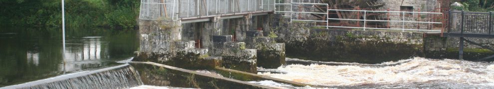
Lock, bridge and cut at Drum
The river is flowing from top left to middle right; a canal cuts across the top of the loop. A long bridge (Drum bridge) crosses canal and river and the space in between.

The bridge over the river
There is a lock to the right (east/downstream) of the canal section of the bridge. The district is called Drumbeg and the lock was, May Blair says, known as The Drum. The towpath is now part of the Lagan Valley Regional Park.

Lagan Valley Regional Park information board
Upstream of the canal bridge, much of the canal itself has been filled in.


The section under the bridge is completely filled in
The bridge itself seems to have been narrowed and lowered, perhaps to strengthen it for modern traffic, and much of the parapet seems to be fairly new.

The narrowed navigation arch. The lock is on the other side of the bridge
The shrubbery made it difficult to see the lock itself properly.

The lock from the bridge: you can just make out the wall on one side

The corner of the lock from ground level

A slightly different view of the same corner

A bollard

A close-up of the bollard

View from lockside to bridge. Note the ramp on the right
The first curious thing
This block or pulley is mounted on the parapet of the bridge. I cannot say whether it was in the same position when the canal was in use but I have no reason to believe that it was not.

The block on the parapet
May Blair says:
Another interesting relic at Drumbridge is the metal pulley which can still be seen on the parapet wall. This was the device over which the rope passed as the barge went under the bridge and the horse over. Here also the towpath changed once more to the opposite side of the water.
The Lagan Valley Regional Park website says:
[…] at Drum Bridge iron sheaves or pulleys may be seen on the parapets. The pulley controlled the tow rope as the barge was drawn under the bridge.
I could see only one pulley.

Rope guide behind the block

The rope guide
Because the towpath changed sides here, my guess is that, going upstream, the hauler and the horse walked up the ramp shown above, on to the north-east corner of the bridge, and turned left to cross the bridge. As the horse crossed, the rope, running around the block, would pull the lighter out of the lock (which was very close to the bridge). I presume that, at some point, the lightermen would release the end of the rope; horse and hauler would descend the ramp on the south-west corner of the bridge and resume the tow.
However, that is speculation on my part: there is not enough detail in McCutcheon or Blair. If you know more about it, or can make a more informed guess, please leave a Comment below.
The second curious thing
The horse and hauler are now on the south bank of the canal, heading upstream, but they have to cross the upper end of the river loop. Fortunately, there is a bridge across it.

The bridge seen from the north bank

Close-up of the bridge
Clearly, that bridge is a modern one, but I presume that it had a predecessor, about which I know nothing. The other odd feature is the walls on which the bridge is resting. They are far longer, on both sides, than necessary for a narrow bridge. I couldn’t get an entire length into focus, but here are some photos of sections of the walls.

Downstream, east side 1

Downstream, east side 2

Downstream, west side 1

Downstream, west side 2

Upstream, east side

Upstream, west side
Here are some close-ups of timber and brick.

Timber and brick 1

Timber and brick 2
And here is a not-very-clear photo of the bottom, showing one of several regular structures that seem to run parallel with the walls.

Underwater items
I don’t understand this structure and I would be grateful for any information, or even informed speculation, about its nature and function. I note from the Lagan Canal Trust‘s useful guide [PDF] that the Lagan Navigation Company had a quay at Drum but it’s not clear where it was; I wouldn’t have thought that it needed stone on both sides of the river. I also note from May Blair’s Once Upon the Lagan that there was a pen weir at Lock 6: the term pen weir seems to be peculiar to the Lagan and the canal trust defines it as
A type of dam across a river. Water builds up behind the weir to the required depth, then flows over the top.
A weir at this point might have kept up the level in the section of waterway above Drum Bridge and Lock 6.
I am very grateful to Frederick Gilbert Watson for introducing me to Drum. Pages from his Building over the centuries: a history of McLaughlin & Harvey (Nicholson & Bass, Belfast 2010) can be seen here; click on the icon for that book title.
There is a painting of Drum Lock here;
![]()
[lagan40]


My uncle matt irvine was the last lockeeper when the canal was closed. I used to ride the lighters during the school summer holidays.
I don’t remember the sheaf on the drum bridge, but I remember the bollards, used where the towpath changed sides. They all had grooves made by the ropes. The towrope had a large loop at the lighter end, which disengaged on becoming vertical at the bridge, simply being dropped to the lighterman from the other side while the horse crossed over.
Maurice irvine
Maurice: that’s really interesting, thank you very much, and just the sort of detail that gets lost! If you have any more details like that, do please write them up and publish them somehow. bjg
Pingback: Clever chaps … | Irish waterways history
my grandad samuel eccles worked as lock keeper here i have sadley no more information