This page describes a walking route in Dublin from the abandoned Broadstone Line of the Royal Canal, on the north side of the city, to the equally abandoned Main Line of the Grand Canal, on the south side. The waterways interest along the way is the Liffey, where once the Guinness barges plied. The route was intended as part of a longer walk:
- start at Connolly Railway Station
- walk along Amiens Street and North Strand Road to the Royal Canal
- walk as far as Lock 5 and then back to the junction with the filled-in Broadstone Line (with a possible diversion or two at Lock 5)
- from the junction, walk south along the Line to the Broadstone itself
- continue south along Constitution Hill, then (again with possible diversions) reach the quays
- cross the Liffey and walk along Victoria Quay
- walk up Stevens Lane, James’s Street and Echlin Street to the Grand Canal Harbour
- finish at the Guinness Storehouse.
The description of the walk starts on this page, continues on this and then on this present page, which links it on to this, this and this, the last three of which cover short distances around the Grand Canal Harbour and the Guinness brewery. However, the pages can be read independently of one another. This present page starts on Constitution Hill and ends at Echlin Street. Here’s a Google map.
If you walked the Broadstone Line, and have left the Broadstone itself, you are now on Constitution Hill, the green road running north/south about halfway across the map. You’re just about where it says N2.
Your mission, should you choose to accept it, is to get from there to the Grand Canal Harbour. There is a pink area (St James’s Hospital) close to the bottom along the left-hand edge of the map; just to the right of its upper end is the curved Grand Canal Place, with the Guinness Storehouse to the right of that. That’s where the walk will end.
Constitution Hill to the quays
Walk south on Constitution Hill. The large building on the left hand side of the road, with railings to keep hoi polloi out, is the King’s Inns, where trainee barristers have to eat a certain number of dinners in order to qualify:
16. Commons
(a) Students on the full-time Barrister-at-Law degree course are required to dine in the hall on 10 occasions during the academic year. Details are available from the Under Treasurer.
(b) Students on the modular Barrister-at-Law degree course are required to dine in the hall on five occasions during the first academic year of the course and five occasions during the second academic year of the course. Details are available from the Under Treasurer.
Education Rules of the Honorable Society of King’s Inns Edition of February 2011
Why is it, I wonder, that the words of Adam Smith come to mind?
People of the same trade seldom meet together, even for merriment and diversion, but the conversation ends in a conspiracy against the public, or in some contrivance to raise prices.
Adam Smith Wealth of Nations 1776
Continue until you see The Tap, a pub, on your right.

The Tap
This is a pub with a complicated history. There was a pub called Reilly’s on the site; it was fortified in 1916. During the 1970s, as The Tap, it was a pub worth visiting: small, with a fine bar counter, wooden screens and chairs, some antiques behind the bar which the landlord would display if asked politely. He changed into a dinner-jacket at 5.00pm but wore it with slippers; he always put his hat on when he went to sweep outside. He hated crisps and would neither sell them nor allow them to be consumed on the premises; he would not serve pints to women and, if a chap bought a pint and a glass [in British English, that’s a half] and gave the pint to his female companion, he would be thrown out.
The pub changed hands and was renamed Reilly’s Fort: it gained leaded glass windows and plastic leather benches inside. One visit was enough. It is now once more The Tap.
Getting to the Quays
On the next map, you’re now on the green road running from top to bottom, just where it says N1 at the junction with North King Street.
Here you have a choice. First, you can continue down Church Street (which is what Constitution Hill has now become) to the quays, perhaps pausing at St Michan’s Church to shake the hand of the (alleged) Crusader. William Rowan Hamilton, a man with his own connections with the Royal Canal (and with Lara Croft), is buried in the graveyard.
Second, you could walk directly westward along North King Street to Stoneybatter, and specifically to L Mulligan Grocer (which is a pub). Good food and drink, but check opening hours: at time of writing it’s on restricted winter hours.

L Mulligan Grocer
Across the road, and a little further up, is Drinkstore, which has what is probably the largest range of beers in Ireland — but they apologise for not being able to put the entire range in the shop: they have more on their website.

drinkstore.ie
Third, you could take a more circuitous route through Smithfield. If you like whiskey, you might like to visit the Old Jameson Distillery (all the distilling is done in Cork and the company is owned by Pernod-Ricard, so this is just a tourist thing. Did you know that Marconi‘s mother was a Jameson?). Note that the Google map gives two different locations for this, as well as showing some places that have closed down, so you would be better to follow the map on the Jameson site. I can’t give you a direct link to the map as you have to prove you’re of whiskey-drinking age before they’ll let you look at the site.
A bit to the west, on Blackhall Place, you can see the former premises of the King’s Hospital Blue Coat School, now the HQ of Irish solicitors.

The former King's Hospital school on Blackhall Place
On the quays
But eventually you will reach the north quays of the Liffey, along which you should walk west. I had intended to call your attention to the James Joyce House, 15 Usher’s Island, where the Joyce story “The Dead” (from Dubliners) is set, but the website seems to be dead. I can therefore do no more than to mention the James Joyce Bridge, Dublin’s first attempt at meeting the EU Directive requiring every city to have a Calatrava bridge.
There is another Joycean connection further upriver, where Anna Livia (the original Floozie in the Jacuzzi, not Birmingham’s latecomer) has been relocated, having been moved upriver on what was inaccurately described as a barge. Anna has also been names as The Hoor [Dublin pronunciation of “whore”] in the Sewer.
These literary references remind me of when I saved Dublin from becoming an international laughing-stock. Some years ago, the Dublin Docklands Development Authority proposed to put a trip-boat on the Liffey. Some marketing droid (my guess) was aware that James Plunkett had written a book about Dublin called Strumpet City and, with a commendable innocence, announced that the boat would be called The Strumpet.
At this moment of national crisis I took firm action: I wrote a letter to the Irish Times, which published it on 30 November 2004:
Madam
The Dublin Docklands Development Authority has announced that it will be running river trips next year on its new boat, which it has decided to call The Strumpet.
A tour on the hoor, anyone?
Yours etc ….
I suspect that someone in the DDDA was despatched to buy a dictionary, because the boat was eventually named Spirit of Docklands. Mind you, given the success of the DDDA’s investment strategy, that name might not be altogether free of unfortunate connotations. But I digress.
The National Museum
The National Museum has an outpost in the former Collins Barracks (even more formerly the Royal Barracks), just north of Wolfe Tone Quay (formerly Albert Quay). I wouldn’t bother going near it, though, unless you have a deep interest in frocks.

The stone building is the National Museum (Collins Barracks), seen from Victoria Quay
As far as I can see, the National Museum, which has four sites, possesses one model of a steam railway locomotive, and that’s the closest it gets to having a steam engine. The word “diesel” gets no result on its search engine. Its collecting policy seems to be W B Yeats (in Celtic mode) meets Éamon de Valera: there seems to be little suggesting that anyone in Ireland ever worked in industry, or introduced innovations in transport, or promoted technological or managerial innovation.
They should sell their stamp collection and buy a Bolinder.
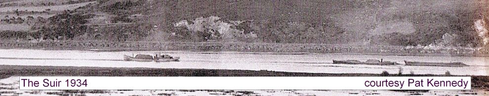
The Guinness Liffey barges
Now, if you’re on Wolfe Tone Quay (north bank) or Victoria Quay (south bank), you’re at the stretch of the Liffey where the Guinness Liffey barges were based.
Old drawings and paintings show other, mostly small, upstream traffic on the Liffey, but as J W de Courcy points out in The Liffey in Dublin (Gill & Macmillan 1996):
In 1873 the brewery built a jetty on Victoria Quay as a terminal for the transport of stout in barrels downstream to the Custom House Quay for transfer to seagoing vessels. This started a long association with the Liffey which would make Victoria Quay the only upstream quay in the city to be in active water-borne trade in the 2oth century.

Looking upstream along Victoria Quay

Looking downstream from the same spot
I strongly urge you to have a look at the ~1900 Ordnance Survey map (switch to Historic 25″). That URL should put you on the landing stage for the barges. Pretty well the whole of the landward side of the quay was occupied by the Guinness brewery, and you’ll see even more of it as you move inland. You can also see the Guinness tramway running around the site, with a tunnel under James’s Street, and a spur from the main line rail at Kingsbridge (now Heuston) station. Guinness also had its own basin connected to the Grand Canal Harbour.

Guinness gatehouse on Victoria Quay
Some people refer to the canal-boats — which carried Guinness along the Grand Canal and the Rivers Barrow and Shannon — as Guinness boats, but they were actually owned by the Grand Canal Company. Guinness did, though, own the Liffey barges. Tim Magennis has a good article here; the Heritage Boat Association has a good detailed article and you can watch the Castleknock here, with its funnel folded down for a low bridge. Here is Terence Cuneo’s pic of loading (find CUN24 and click to expand it).
Here is an article about the Guinness barges that went to Lough Neagh (and about other aspects of the Lough Neagh sand trade). Irish Ship and Barge Fabrication proposes to retrieve some of them. Look under “Ships” for Clonsilla, Killiney, Vartry and Slaney as well as the page to which I provide the link.
There is a photo of a model of a Guinness barge, in the Guinness Storehouse, on my page here and what I think to be the last of the Guinness barges still afloat here. The National Library has a photo here (click to expand) and there’s a first-generation barge steaming down the Liffey about 25 seconds into this British Pathé newsreel.
You can hear Margaret Barry singing Two Hundred Years a-Brewing a tribute to Guinness (lyrics here, towards the bottom of the page). I’d give you the lyrics of The Wreck of the Vartry (one of the Guinness barges) but it may still be in copyright. Fergus Allen’s The Fall certainly is, so I suggest that you should not go to this website to read the text.
It seems that the first Liffey Swim, in 1920, started from a Guinness barge, presumably tied to the landing stage. Jack B Yeats, brother of the poet, painted it once. My memory (I did it only once) is of starting from the steps shown in this pic, which I think were just upstream of the blue bridge in my photo above, but I don’t remember a pontoon or anything.
Heuston (Kingsbridge)
Onward. Upstream to Heuston (formerly Kingsbridge) station.

The front of Heuston Station

Heuston with traffic and red-line LUAS tram
That’s the same LUAS line as at Connolly Station.
Another map:
From Victoria Quay, turn left on to St John’s Road W, then left again on to Steevens Lane. This is closed to road-traffic; the LUAS lines run along it. You could, if you haven’t been on a LUAS, jump on to one at Heuston and travel to St James’s Hospital; it takes you a bit out of the way but it means you don’t have to climb the hill under your own steam.
At the bottom of the hill, Dr Steevens Hospital, freed from the walls that formerly confined it, now houses health service offices; at the top of the hill, on the right, is St Patrick’s Hospital for Imbeciles (its name has been modernised), founded with a bequest from Dr Jonathan Swift, late Dean of St Patrick’s Cathedral. In his own Verses on the Death of Dr Swift (1731) he wrote:
He gave the little wealth he had
To build a house for fools and mad;
And showed, by one satiric touch,
No nation wanted it so much.
He did not die until 1745; his epitaph reads:
Ubi saeva indignatio ulterius cor lacerare nequit.
Turn left at the top of Steevens Lane and head east on James’s Street. You may want to travel as far as the famous gate of the brewery, but if you do return to Echlin Street. On the Google map, it runs from James’s Street to the bottom of the map, about half way across.

Corner of Echlin Street and James's Street
That will bring you on to the second of my four pages about the Grand Canal Harbour and the area around it, including Guinness and its Storehouse visitor centre. You can follow pages 2, 3 and 4: that sounds like a lot, but in fact they just take you around the old harbour. There are some pics inside the harbour, but on my most recent visit access had been barred by a strong gate. Page 1 of the 4 pages is here; if you’ve followed this route it won’t be all that useful because it follows the canal in from the west, ending up at the bottom of the Grand Canal Harbour.
Feedback on this walk would be welcome.

