Some years ago, when we had an elderly cruiser on the Shannon, we arrived below Tarmonbarry at lunchtime, when locks are closed. At the time, Tarmonbarry Lock was closed for repairs and traffic was being diverted through the (much smaller) Clondra Lock and the Camlin River, rejoining the main line of the Shannon just below Lough Forbes.
We had a standard canal lock key (windlass), and we knew that we would be able to operate Clondra Lock and let ourselves through. Unfortunately, none of the other boats in the queues (even PM’s VM), either below or above the lock, were so equipped. So, in order to be able to get through ourselves, I had to operate the lock for several other boats in each direction — in the pouring rain. Eventually, our boat got into the lock, up and out, and I hopped back on board, no doubt leaving the other boaters wondering why they were being left to await the keeper’s return from lunch.
Tempora mutantur, et nos mutamur in illis, comme on dit, and it seems that it is no longer possible for the well-equipped boater to bypass Tarmonbarry at lunchtime. However, the lock at Clondra is still worthy of attention.
Googling Clondra + Longford, incidentally, gets 16,500 hits, Cloondara gets 2,470, Clondara 806 and Cloondra 206. Vox populi, vox Dei, for all Alcuin argued to the contrary, so Clondra it is.
Shannon v01
The first serious attempt at making the Shannon navigable was that of the Commissioners of Inland Navigation from 1755 onwards. Under their direction, Thomas Omer tackled the river between Carrick-on-Shannon and Killaloe. He built these locks (listed here from downriver to upriver):
- Meelick: after the lock was repaired in 1806, it became known as Hamilton Lock. The Shannon Commissioners later bypassed it
- Banagher: a short canal with a flash lock (only one set of gates). The remains, along with the distinctive Omer lockhouse, are still visible on the west bank, but the canal was abandoned

The Omer lockhouse at Banagher
- Shannonbridge: another short canal with a flash lock

The Omer lockhouse at Shannonbridge (on the left)
- Athlone, at the foot of Lough Ree: Omer’s 1.5-mile canal ran to the west of the river, with one lock and a guard lock. The canal is still visible but the lockhouse is gone
- Lanesborough, at the head of Lough Ree: another short canal with a flash lock. The lockhouse is gone
- Clondra: Omer avoided using the Shannon, which was (and is) shallow above Tarmonbarry, instead providing a lock up into the Camlin River, rejoining the Shannon downstream of Lough Forbes. Richmond Harbour, the western end of the Royal Canal, later locked down into the Camlin

Richmond Harbour empty of boats (July 2010)
- Roosky: a canal and a lock
- Jamestown: a canal and a lock, bypassing a rocky loop of the Shannon. This work was finished by someone other than Omer.
Shannon v02
However, the Commissioners for the Improvement of the Navigation of the River Shannon, working in the 1840s, discarded many of the original locks. Hamilton Lock at Meelick was bypassed by the new Victoria Lock; the flash locks at Banagher, Shannonbridge and Lanesborough were removed; the canals at Athlone and Roosky were abandoned and new locks built in the river (more on Athlone Lock here). Even at Jamestown, although the canal was retained, it had to be widened and deepened and the lock had to be repositioned.
That left Clondra. Thomas Rhodes proposed building a new canal, between the Shannon and the Camlin, with its upstream and downstream ends more or less at the existing junctions between Camlin and Shannon. However, the final decision was to build a new weir and lock at Tarmonbarry, in the Shannon itself.
But, presumably because the Royal Canal joined the Camlin, the old route and the old Clondra Lock were retained (and improved). So, although Clondra Lock has been rebuilt, repaired and refurbished several times, it is the only lock on the Shannon that is still in use after surviving the Commissioners of Inland Navigation, the Directors-General of Inland Navigation, the Commissioners for the Improvement of the Navigation of the River Shannon, the Board of Works, the Office of Public Works [read about their 1969 restoration work here], the Department of Arts Culture & the GaeItacht (including Dúchas Waterways) and Waterways Ireland.
If I’m wrong about that, please correct me, but I think it makes Clondra Lock pretty important.
Clondra and the Camlin
The Ordnance Survey historic map is very interesting, because the 6″ version shows Tarmonbarry before the lock was built. Note all the evidence of economic activity around the area.
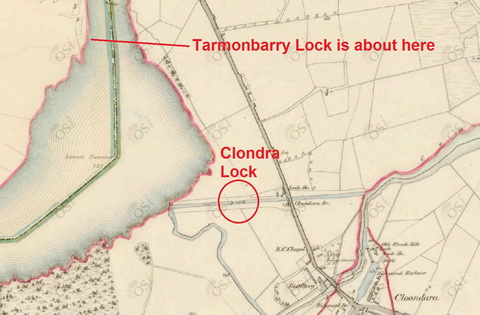
Clondra ~1840 (copyright OSI)
![]()
The Google maps are not very useful because they don’t show natural features, but the Google satellite photo is OK. However, I can’t get the link to work properly: this seems to be centred on Longford, rather than on Clondra, despite my telling it to use Clondra, so you may have to move westward (follow the road, the N5, to get to the Shannon).
All going well, you should then be able to see the wide area of water below Tarmonbarry (marked by its restaurants, Keenans and the Purple Onion, rather than by its name). A straight canal leads from left to right, just above the name Cloondara; the lock is before the road bridge. The Camlin then goes under the N5 (major road) before wriggling its way east (right), north and then west, to rejoin the Shannon. You should also be able to see the nasty U-bend where it changes from north to west.

The Omer lockhouse at Clondra

Approaching the lock from the Camlin (July 2010)
The lock itself

Tied above the lock: not much room

We’re in the right place

Sloping wall

The lock office

The control panel

The works 1

The works 2. Future generations will want this sort of detail (I think)
Bollards
The bollards in the lock are the small modern type, painted red as we’re on the North Shannon.

Lock bollards
Note that all the bollards are on the photographer’s left (looking upstream): the lock is not wide enough for two lines of boats. Its dimensions are 97.33 feet (29.67m) mitre to mitre, 82.08 feet (25.02m) mitre to sill, 18.58 feet (5.66m) wide, drop 7.5 feet (2.29m).

Gates, bollards, controls
Racks/paddles
There are no land-racks (ground paddles).
The upper gates had two racks each side. Those on the gate nearest the controls have been converted to hydraulic operation.

Upper gate racks
Those on the side furthest from the controls retained manually-operated racks.

Racks on the far upper gate
However, one rack has been removed altogether.

Note the missing rack (paddle gear)

There it was, gone
You may be able to see, in that photo, that the remaining manual rack has had a white collar attached so that it can’t be operated by a canal lock key (windlass). Here’s a close-up from the other side.

Close-up of the rack
Waterways Ireland doesn’t want you letting yourself through. Instead, this is what you should do.

Who you gonna call?
The lower gates had only one rack each. That on the control side is now hydraulic, but the other retains its wheel.

The hydraulic rack on the lower gate

The two lower gates

A close-up of the wheel
The only other Irish lock I can think of that has wheels on the racks is the Victoria Lock (sea lock) on the Newry Ship Canal, and those wheels are vertical (the axles are horizontal). If you know of others, or others that once used wheels, do please leave a Comment below.
Despite the availability of hydraulics, the wheel is still used.

Wheel in use 1

Wheel in use 2

Wheel in use 3

Wheel in use 4
The gates: other features

Walkway; red handle on gate beam

Counter-weight on the lower-gate beams

Footboards

On this side, the handle is on top of the beam

Collar

The upper gates open

Gate timbers
Some aspects of operation

The lock filling …

… for a Waveline cruiser

Keeper at work

The lock filling 1

The lock filling 2

The lock filling 3

The lock filling 4

The lock filling 5
Below the lock

The seat below the lock

The lower landing stage and gates

Looking down the canal towards the Shannon
Clondra: a historic lock.
Sources
Ruth Delany Ireland’s Inland Waterways: celebrating 300 years Appletree Press, Belfast 2004
Ruth Delany The Shannon Navigation Lilliput Press, Dublin 2008
Ordnance Survey maps
Reports of the Commissioners for the Improvement of the Navigation of the River Shannon, Ireland 1840 to 1850
Lock dimensions courtesy of Waterways Ireland
[mus60]


nice pic
Thank you. bjg
I first came on the Shannon in 1963 aboard Inis Cealtra of K Line Cruisers Jamestown and Shannon Harbour. She was built in a cottage, which required partial demolition to get her out, and had a peat stove and a Volvo Penta; and a nifty hinged rear transom. It is delightful to catch up on the history of this earlier navigation work, and to see it functioning. PH
Pingback: Staffing the Shannon | Irish waterways history
Pingback: Header photo 20191202 | Irish waterways history