This page owes its existence to Ewan Duffy of the Industrial Heritage Ireland website and blog, who drew my attention to the existence of the Lixnaw canals.
The shamrock rivers (OSI ~1900)
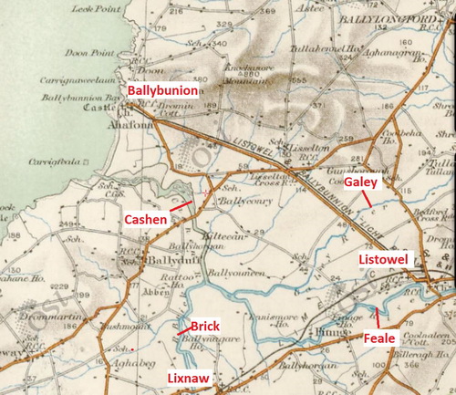
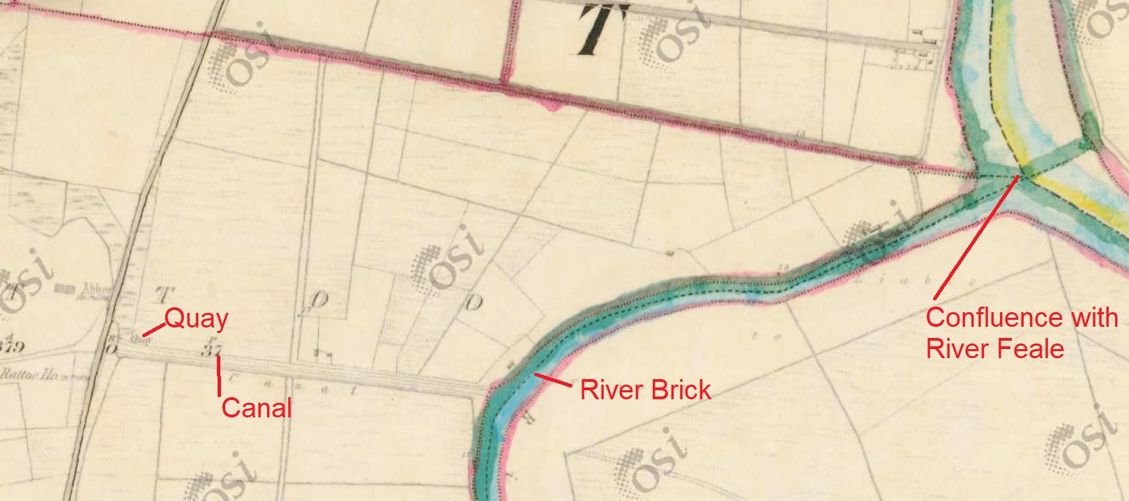
Lixnaw, in Co Kerry, stands on (or near) the River Brick, which is one of three — the Feale and the Galey are the others — that, once joined, form the Cashen (or Cashin), which flows into the sea close to Ballybunion. As Samuel Lewis put it:
The rivers [of Co Kerry] are numerous, but none of great length. The Feale rises in the mountains that separate Kerry and Limerick, and receives the Gale or Galey near Rattoo from the north-east, and afterwards the Brick from the south. From the junction of these three, the united stream takes the name of Cashen, and discharges itself into the estuary of the Shannon, near Ballybunnian. The tide flows up the whole of the Cashen, and boats proceed as far as Lixnaw, on the Brick, at high water.[1]
As far as some search engines and I can see, the earliest mention of Lixnaw and its canals was by Dr Charles Smith in 1750:
Towards the center of this barony of Clanmaurice is Lixnaw, the antient seat of the earls of Kerry […]. This seat stands agreeably on the river Brick, which is here cut into several pleasant canals, that adorn its plantations and gardens. The improvements are very extensive, most of the vistoes and avenues terminating by different buildings seats and farmhouses. The tide flows up to the gardens, whereby boats of a considerable burden may bring up goods to the bridge near the house: here are two stone bridges over the Brick, the oldest of which was built by Nicholas, the third baron of Lixnaw, who was the first person that made causeways to this place, the land being naturally wet and marshy.[2]
Dr Smith’s account was so good that several other writers, feeling that they could not better it, adopted it as their own. Here is Philip Luckombe in 1780:
From Rattoo we proceeded to the south-east, and crossed the river Brick to Lixnaw, the ancient seat of the earls of Kerry, agreeably situated on that river, which is here cut into several pleasant canals. The improvements are very extensive, most of the vistoes and avenues terminating by different buildings, seats, and farm-houses. The tide flows up to the gardens, whereby boats of a considerable burden may bring up goods to the bridge near the house: here are two stone bridges over the Brick.[3]
Luckombe’s plagiarism was so extensive that Susan M Kroeg was able to write an article about it[4], but he was not alone in stealing Smith’s work:
Lixnaw, a bar[ony] now called Clanmaurice. in co Kerry, prov[ince of] Munster, which gives title of baron to the earls of Kerry; the village here of this name being their antient seat; where the castle was erected. This seat stands agreeably on the river Brick, which is here cut into several pleasant canals, that adorn its plantations and gardens; the improvements are extensive, most of the vistoes and avenues terminating by different buildings, seats and farm-houses. The tide flows up to the gardens. whereby boats of a considerable burden may bring up goods to the bridge near the house; here are two stone bridges over the Brick, the oldest of which was built by Nicholas the 3d baron Lixnaw, who was the first person that made causeways to this place, the land being naturally wet and marshy. Lat 52:15, Ion 9:15.[5]
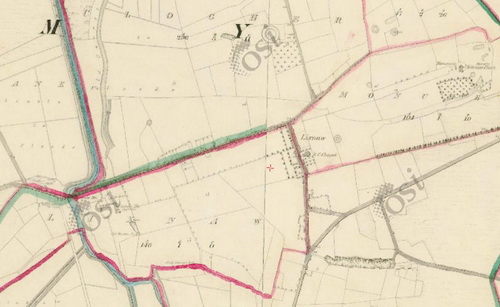
But enough of this. Lixnaw had at least four canals. The next map extract shows the junctions of three of them. One comes down from the north (ie from the top of the map), turns briefly west and then south(ish) again; a second goes off to the south west from there and a third heads for the middle of the bottom edge of the map. All three of those are marked with the word “canal” on the 6″ Ordnance Survey map.
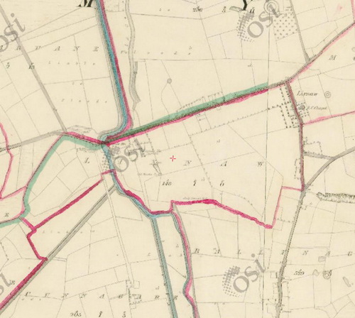
The three canals (OSI ~1840)
The northernmost canal, the one at the top of the previous map, is the furthest downstream. It cuts off the winding “Old Course of River”.
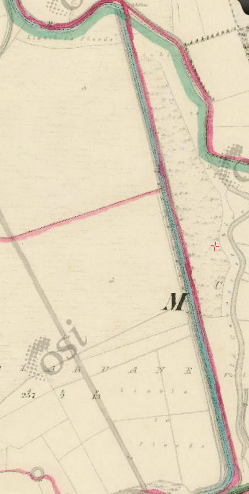
The northernmost canal (OSI ~1840)
And it has a “Lock and Sluice” at the downstream end — or at least it did when the survey for the 6″ OSI map was done, many years after the canal was made. By the time of the 25″ map of around 1900, there were two sluices instead.

The lock and sluice (OSI ~1840)
That lock and sluice might not have constituted a lock as we now understand the term: it might have been something like a tide-gate, designed to stop water receding with the tide, thus keeping up the level in the canals. There was such a lock on the Clodiagh near Portlaw.

The bridge (OSI ~1840)
The fourth canal
I’ve so far shown only three of the four canals. The fourth came to my attention only recently.
Lixnaw: the fourth canal (OSI 6″ ~1840)
This canal was definitely used for navigation: it has a quay at the end of it, which is close to the ruins of Rattoo House and Church.
Bridges
Maybe it’s my eyesight, but I can see only one bridge, although Lewis and the earlier writers said that there were two. You can have a look for yourself.
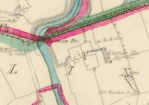
The bridge and Lixnaw House (OSI ~1840)
Here’s Lewis:
The village [Lixnaw] is situated near the river Brick, over which, at a short distance from each other, are two stone bridges: it consists of two streets of tolerably good houses, and contains a spacious RC chapel, and a school supported by subscription, to which Mrs. Raymond contributes £6 per annum. […] Limestone of superior quality, in some places approaching to marble, is found in the vicinity, and worked both for useful and ornamental purposes; and sea-weed and sand for manure are brought in boats up the river Cashen and thence by the Brick to the town. It is stated that these rivers might be made navigable for larger vessels at a very moderate expense; and Mr. Nimmo, the government engineer, many years since, suggested a plan for that purpose, and for draining and bringing into cultivation the extensive tracts of marsh and bog in the neighbourhood.[6]
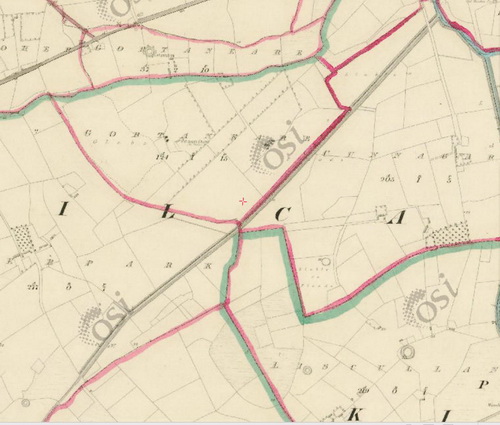
The canal to the south west (OSI ~1840)
Neap tides flowed much further up.
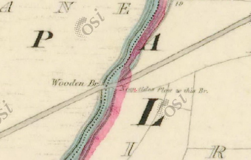
Neap tides (OSI ~1840)
Here’s what the Parliamentary Gazetteer has to say:
BRICK (The), a rivulet of the barony of Clanmaurice, co Kerry, Munster. It rises on the southern border of the barony, 2¼ miles east-south-east of Ardfert, and 3 north of Tralee; and runs between 10 and 11 miles, in the direction of north by west, past Abbey O’Dorney, and through the demesne of Lixnaw, to the Cashen, 4½ miles above that river’s expansion into the Lower Shannon. The tide flows up to the gardens of Lixnaw, 2¾ miles above the confluence with the Cashen, and brings thither boats of considerable burden laden with goods; and the rivulet is there ramified by canal cuts among the gardens and plantations.[7]
The canals today
The Lixnaw canals are not forgotten: here, for instance [PDF], is an Environmental Protection Agency report, on a waste water discharge licence application, wherein the “Lixnaw Canal” is mentioned. And here is Google’s aerial photo (or whatever it is), showing the three canals quite clearly:
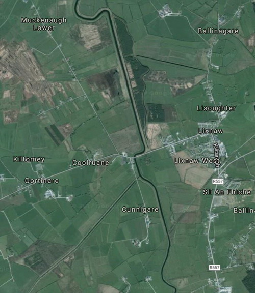
The Lixnaw Canals (imagery (c) 2017 DigitalGlobe, map data (c) 2017 Google)
But the most interesting modern mention is in an article by Finola O’Kane Crimmins, Associate Professor in the School of Architecture at UCD. The article is Chapter 3 of a book called Routes, Roads and Landscapes[8] and most of the text is, at least for the moment, accessible here, although most of the illustrations are invisible. She quotes Charles Smith (although I’m not sure why she describes him as “writing from the English point of view”, given that he was born in Ireland) and takes issue with John Andrews who (in an article which, coincidentally, I’ve been reading recently), she feels, gives inadequate weight to the influence of aesthetic considerations on the planning and construction of roads> She uses Lixnaw as an example:
No Roman linked all the notable old and new monuments for many miles around into Lixnaw’s legible diagram of Fitzmaurice power, influence and connectivity […]. At either end of ‘the new road’ lay the Hermitage and the Monument, carefully flanking and framing the bulk of the demesne lands which lay south of the road, a prime orientation for an early eighteenth-century sequence of walled courts, gardens, orchards and summerhouses. Carefully positioned to benefit from the numerous prospects of mountains, ruined towerhouses and other monuments that lay to the south, Lixnaw’s roads also defined the cross-axis of her great canal project, where the natural bed of the river Brick was usurped by two new lines of canal. These sidestepped carefully around the central house to allow the principal reception rooms long views over canals draining improved farmlands. Nor is it strange that they drove the straight routes through the bog, as the road was partly intended to ensure that the bog should no longer exist.
You can see what she’s talking about on this map, although you might be better to look at it in close-up on the OSI website.
The canals and the village (OSI ~1840)
I’m not, though, convinced that aesthetic considerations, even combined with drainage, entirely explain the Lixnaw canals. If that sluice and the lock were original features, they would presumably have acted to keep water in the canals, which suggests that navigation might have been more important than drainage. The orientation of the northernmost (ie downstream) canal might have been determined by a need to use an existing channel and the bridge or bridges. And the south-western canal seems unlikely to have added much to the view from the house. I would like to know more about the construction and use of the canals.
I did learn, though, that some part in the construction was played by one Seán Mór Seoighe, from Connemara, who may have been a steward, a builder and a stonemason — and the ancestor of James Joyce.[9]
Finally, Finola O’Kane Crimmins says
[…] once removed permanently to England, the Fitzmaurice family, later Marquises of Lansdowne, could not direct infrastructural improvements as well as those living on the ground.
It depends what you mean by “direct”, I suppose: it was the third Marquis who pushed through the House of Lords the bill that provided almost £600,000 to improve the navigation of the River Shannon.
Notes and sources
[1] Samuel Lewis A Topographical Dictionary of Ireland comprising the several counties, cities, boroughs, corporate, market, and post towns, parishes, and villages, with historical and statistical descriptions; embellished with engravings of the arms of the cities, bishopricks, corporate towns, and boroughs, and of the seals of the several municipal corporations; with an Appendix describing the electoral boundaries of the several boroughs, as defined by the Act of the 2d and 3d of William IV S Lewis & Co, London 1837
[2] Charles Smith MD The Ancient and Present State of the County of Kerry. Containing a natural, civil, ecclesiastical, historical and topographical description thereof Dublin 1774 but first published 1756
[3] [Philip Luckombe] A Tour through Ireland; wherein the present state of that kingdom is considered; and the most noted cities, towns, seats, buildings, loughs, &c described. Interspersed with observations on the manners, customs, antiquities, curiosities, and natural history of that country. To which is prefixed, a general description of the kingdom; with the distances between the ports, &c on the coast of Great-Britain, and those on that of Ireland T Lowndes, London 1780
[4] Susan M Kroeg ‘Philip Luckombe’s “A Tour through Ireland” (1780) and the Problem of Plagiarism’ Eighteenth-Century Ireland/Iris an dá chultúr Vol 19, Eighteenth-Century Ireland Society 2004; stable URL
[5] William Wenman Seward Esq Topographia Hibernica; or the topography or ireland, antient and modern, giving a complete view of the civil and ecclesiastical state of that kingdom; with its antiquities, natural curiosities, trade, manufactures, extent and population. Its counties, baronies, cities, boroughs, parliamentary representation and patronage; antient districts and their original proprietors. Post, market, and fair towns; bishopricks, ecclesiastical benefices, abbies, monasteries, castles, ruins, private-seats, and remarkable buildings. Mountains, rivers, lakes, mineral springs, bays and harbours, with the latitude and longitude of the principal places, and their distances from the metropolis and from each other. Historical anecdotes, and remarkable events. The whole alphabetic ally arranged and carefully collected. With an appendix, containing some additional places and remarks, and several useful tables printed by Alex Stewart, Dublin 1797. The same text appears in The Rev G Hansbrow An Improved Topographical and Historical Hibernian Gazetteer: describing tile various boroughs, baronies, buildings, cities, counties, colleries, castles, churches, curiosities, fisheries, glens, harbours, lakes, mines, mountains, provinces, parishes, rivers, spas, seats, towers, towns, villages, waterfalls &c &c &c scientifically arranged, with an appendix of ancient names. To which is added an introduction to the ancient and modern history of Ireland Richard Moore, Dublin and others 1835
[6] Samuel Lewis op cit
[7] The Parliamentary Gazetteer of Ireland, adapted to the new poor-law, franchise, municipal and ecclesiastical arrangements, and compiled with a special reference to the lines of railroad and canal communication, as existing in 1844–45; illustrated by a series of maps, and other plates; and presenting the results, in detail, of the census of 1841, compared with that of 1831 Volume III N–Z A Fullarton and Co, Dublin, London and Edinburgh 1846
[8] Finola O’Kane “‘To Lead the Curious to Points of View’: The Eighteenth-Century Design of Irish Roads, Routes and Landscapes” in Mari Hvattum et al eds Routes, Roads and Landscapes Ashgate Publishing Ltd 2011, online here; Routledge seem to have published a paperback edition in 2016
[9] John Wyse Jackson and Peter Costello John Stanislaus Joyce: the voluminous life and genius of James Joyce’s father Fourth Estate 1997 (HBK), 1998 (PBK), St Martin’s Press; Chapter 1 here
![]()
[wck75]


I am flabbergasted by all that valuable work being done by irishwaterwayshistory. Without your efforts much would be lost. Thank you very much.
You’re welcome. Thanks. bjg
This is very interesting. Did you find any reference to brickmaking in your research on the Lixnaw area? The Irish Folklore Commission survey of 1946 includes a response saying brick had been made in the area and noth Wilkinson (1847) and Kinahan (1888) mention very good bricks made near Listowel. I’m writing a gazetteer of brickmaking locations so interested in any references you might have encountered either to brickmaking or transporting of brick in this area..
I didn’t find anything, alas. I’ve just had a quick look through various directories and gazetteers and I see nothing relevant; I also flew over the area using the OSI 6″ map but again without success (though I did find a fourth canal, which I’ve added to the page). Sorry about that.
I presume you have the Clonown brickfields below Athlone.
bjg
Thanks for coming back to me so quickly. Yes, I have many brickfields associated with canals and rivers elsewhere in the country. Just got excited when I saw these canals that I’d never heard of before! Many thanks, Susan
I’ve just searched the British Newspaper Archive for Lixnaw+bricks and Lissanaw+bricks, but again without result.
Good luck with the work: it sounds as if it will be a very useful resource.
bjg