Tag Archives: O'Briensbridge

Races at Castleconnell

There was a considerable multitude of persons at Castle-Connell, yesterday, to enjoy the spectacle of boat-racing. Vehicles of all descriptions were in requisition, and the pedestrians of both sexes were numerous. The weather was delightful, and the enchanting scenery of this far-famed watering place appeared to the very best advantage. The band of the County Limerick Regiment, which attended in full uniform, gave a new zest to the festivities of the occasion.

The contest on the river was between Castleconnell and O’Brien’s-bridge for the premiums advertised last week, and the Castleconnell men were victorious.

We understand the Strand men have challenged Castle-Connell to pull from O’Brien’s-bridge to Castle-Connell for £7, any day next week.

Dublin Observer 8 September 1832

Oberkommando der Wehrmacht and O’Briensbridge

Boogie on over to the splendid David Rumsey Historical Map Collection and put

ireland shannon

in the search box. All going well, you’ll get a set of 14 pages published by Generalstab des Heeres (the German Military High Command) in 1940, with drawings, maps, photos and a page of text about the Shannon. The set includes Clonmacnoise (no doubt because the Wehrmacht intended to go there on pilgrimage), Foynes and, in particular, Ardnacrusha, O’Briensbridge, Parteen Villa and Killaloe.

Industrial railway enthusiasts may also be interested.

And the collection includes many photos of British ports and other installations.

The mystery of Mr Worrall

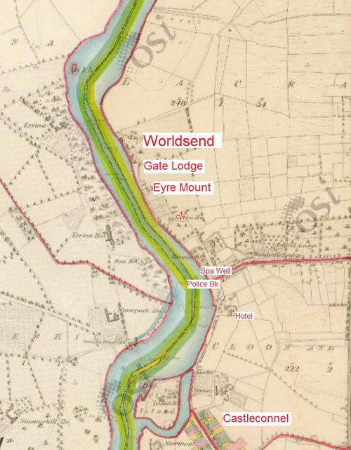
Castleconnell and Worldsend, Co Limerick (OSI 6" ~1840)

Castleconnell and Worldsend, Co Limerick (OSI 6″ ~1840)

The authors of a book called Village by Shannon, about Castleconnell, Co Limerick, say that the area of Worldsend, at the northern end of Castleconnell, derives its name from Worrall’s Inn, an establishment operated by a Mr Worrall in the early eighteenth century.

That may be so, but the book’s accounts of river-borne traffic — to a quay at the inn — do not seem to accord with what is known about the history of the Shannon navigation, and in particular of the Limerick Navigation between the city and Killaloe. Here are some of the problems.

My OSI logo and permit number for website

Why the Shannon floods

From the search terms used, it seems that many people are visiting this site with questions about Parteen Villa Weir, water levels, Shannon floods and so on. They are not this site’s primary focus, but some non-technical information might be of interest.

The best place to start is with this quotation from a former web page of the Shannon International River Basin District:

The Shannon International River Basin District is the largest in Ireland at more than 18,000 km2 in area. It covers the natural drainage basin of the Shannon river itself, stretching from the source of the River Shannon in the Cuilcagh mountains in Counties Cavan and Fermanagh to the tip of the Dingle peninsula in north Kerry. It also includes coastal parts of Kerry and Clare which drain to the sea. It flows through 18 local authority areas and is also an international RBD as a small portion of County Fermanagh in Northern Ireland drains underground to the Shannon Pot.

The district is about one fifth of the area of the island, one quarter the area of the state. Rain that falls on that area of land ends up in the Shannon (or in a few small rivers in Clare and Kerry that flow to the sea). Some goes to the Shannon estuary or its tributaries; most flows into the non-tidal Shannon, which means the river upstream of Limerick.

The nature of the Shannon

Ireland has been described as saucer-like, with a high rim and a low flat centre. It’s not entirely true, but there certainly is a very large central plain, and the Shannon flows down through the middle of that. And, because the land it flows through is flat, the river falls very little.

In 113 miles from Leitrim to Killaloe, the Shannon falls just over 30 feet; the navigation channel needs only five locks. [By way of contrast, the Thames has 45 locks over 135 miles; the Trent has 12 locks over 42 miles.] So extra rainwater allows the Shannon to spread out, covering a much wider area, and it takes time for that water to drain away downstream. But many of the rivers that flow into the Shannon have been subjected to drainage schemes, so they can get rid of their flood waters quickly … into the Shannon.

Why don’t they open [or close] the weirs?

There are some weirs on the Shannon, designed to keep a minimum depth in the river for navigation; there are also some natural obstacles that hold water back. But once the level has risen high enough, water simply flows over the top of the weir, and there is nothing useful anybody can do — apart, of course, from farmers’ representatives and politicians, who can always make use of a photo opportunity.

The bottleneck

Almost all the water that enters the non-tidal Shannon will eventually flow through Killaloe, the town at the southern end of Lough Derg [it’s on the west bank, in Co Clare; the east bank is Ballina, in Co Tipperary].

As James Robinson Kilroe wrote in 1907,

[…] we have the formidable barrier at Killaloe, naturally damming up a considerable depth of water in Lough Derg, and the river falling away southward by a series of rapids which correspond with drops in the canal, south of O’Briensbridge […], along an alternative course, possibly one used by a branch of the Shannon.

The diagrams with that article are worth a look.

In the twelve Irish (fifteen statute) miles between Killaloe and the tidewater at Limerick, the river falls about 100 feet: more than three times its fall from Leitrim to Killaloe. In the nineteenth century, the water level at Killaloe used to change by about eleven feet between summer and winter — even without storms.  The old Limerick Navigation, including the canal Kilroe mentioned, could drain only a small amount of water (which could put the navigation out of action); the rest went down the river’s original course through the Falls of Doonass.

The relief channel

Nowadays, the Falls of Doonass are a shadow of their former selves, and the water level through O’Briensbridge, Castleconnell and Plassey is much below its previous levels. I suspect that the older, larger trees along the river show the original level, with the newer, smaller trees having grown since the 1920s.

The cause was the construction of a relief drainage channel in the 1920s. This channel is controlled by a weir at Parteen Villa [not to be confused with Parteen].

Actually, of course, it’s not a relief drainage channel. The weir [sometimes referred to as the Hydro Dam] controls the flow of water to the original course of the Shannon [the right-hand or eastern channel, which gets the first 10 cubic metres of water per second] and the headrace for the hydroelectric power station at Ardnacrusha [the left-hand or western channel, which gets the next 400 cubic metres of water per second, 100 for each of its turbines]. The power station was built to use that 100-foot fall of the Shannon, concentrated between Killaloe and Limerick, to generate electricity.

But one effect of the construction of Ardnacrusha was to provide a channel, the power station headrace, capable of taking [at least] 400 cubic metres of water per second away from the original river channel, thus reducing the likelihood of flooding.

Cumec

Water experts talk about cumecs: a cumec is a flow of one cubic metre, or 1000 litres, of water per second. And a cubic metre of water weighs about one [metric] tonne, which is roughly the same as an imperial ton. So one cumec is one ton of water per second, which is a lot.

It was said, on 8 December 2015, that the ESB, using Parteen Villa Weir, had released 315 cumec down the original course of the Shannon on the previous day and had increased that to 375 cumec. If the Ardnacrusha headrace was getting 400 cumec, then the amount of water being discharged from Lough Derg and the upper Shannon had doubled.

Floods

As far as I can see, the Shannon has always flooded. The 2009 floods affected some nineteenth century houses, which I guess would have been flooded even worse before Ardnacrusha was constructed. However, I suspect that more houses have been built on the flood plain since then. But I don’t see that there is any way to prevent Shannon floods.

Envoi

There is a good article in the Irish Times of 9 December 2015; it will no doubt disappear behind a paywall at some stage.

Here is an ESB infographic about the Shannon.

Shannon water levels 8 December 2015

North to south (more or less)

Floods 20151208 Shannonbridge 01_resize

Shannonbridge upstream

Floods 20151208 Shannonbridge 07_resize

Shannonbridge downstream

Floods 20151208 Shannon Harbour 04_resize

Shannon Harbour: 36th lock

Floods 20151208 Shannon Harbour 06_resize

Shannon Harbour: below the 36th

Floods 20151208 Shannon Harbour 16_resize

Shannon Harbour: road to Banagher closed

Floods 20151208 Banagher 03_resize

Banagher: the harbour above the bridge

Floods 20151208 Banagher 05_resize

Banagher: the harbour’s sole inhabitant

Floods 20151208 Banagher 09_resize

Banagher: work goes on

Floods 20151208 Portumna bridge 01_resize

Portumna Bridge: Hawthorn moving

Floods 20151208 Portumna bridge 03_resize

Portumna Bridge

Floods 20151208 Portumna bridge 02_resize

Below Portumna Bridge

Floods 20151208 Portumna bridge 10_resize

Above Portumna Bridge

Floods 20151208 Portumna bridge 12_resize

Portumna Bridge: Waterways Ireland yard

Floods 20151208 Mountshannon 01_resize

Mountshannon

Floods 20151208 Mountshannon 04_resize

Mountshannon: the main quay

Floods 20151208 Scarriff 01_resize

Scarriff: the river in flood

Floods 20151208 Scarriff 02_resize

Scarriff: the river flowing on to the road to the harbour

Floods 20151208 Scarriff 06_resize

Scarriff: sandbags blocking the road …

Floods 20151208 Scarriff 04_resize

… to the Waterways Ireland Shannon HQ. Anyone in the building must have waded there

Floods 20151208 Tuamgraney 01_resize

Tuamgraney

Floods 20151208 Killaloe 16_resize

Killaloe: the flash lock

Floods 20151208 Killaloe 26_resize

Killaloe bridge from downstream

Floods 20151208 O'Briensbridge 02_resize

O’Briensbridge

Floods 20151208 O'Briensbridge 05_resize

Water level with the quay at O’Briensbridge

Floods 20151208 O'Briensbridge 10_resize

Flooded fields at O’Briensbridge

O’Briensbridge is on the original course of the Shannon, downstream of Parteen Villa Weir, which controls how much water goes via the original course and how much goes to the hydroelectric power station at Ardnacrusha.

Normally, the original course gets the first 10 cubic metres per second (10 cumec, they say) of water and Ardnacrusha gets the next 400, 100 for each of its four turbines. In floods, any excess is sent down the original course, through O’Briensbridge, Castleconnell and Plassey. One newspaper today said that, on Monday 7 December 2015, 315 cumec had been sent down the original course and, on Tuesday 8 December, 375 cumec.

The water levels are still below the peak achieved in November 2009, but there is more to come: as the Shannon drains a very large amount of Ireland, and as it is falls very little in its upper reaches, it takes a long time for the runoff to reach Killaloe and Parteen Villa. It may be that the ESB, which controls Ardnacrusha and Parteen Villa, is now running down the level of Lough Derg to make room for the water that has yet to arrive from the upper Shannon.


Shannon history

Folk interested in the history of the Shannon Navigation, and in particular in the work of the Shannon Commissioners in the 1840s, may like to get hold of an article “Steam, the Shannon and the Great British breakfast”, published in the Journal of the Railway & Canal Historical Society Vol 38 Part 4 No 222 March 2015.

Plassey in 1851

Plassey August 2010 37_resize

Free the Black Bridge

Here is a page about a cot race at Plassey in 1851.


The perils of duck-shooting

On Tuesday morning, Mr Ounsel, of Portland near Portumna, left Killaloe at 6 o’clock, to walk down the bank of the Canal to O’Brien’s Bridge, there to meet the packet boat — he took with him a long gun for the purpose of shooting ducks. As no account could be had of him at O’Brien’s Bridge, it was supposed he fell into the river, and in the course of the day a hat, and a book belonging to him were found on the shore; there is no doubt but he has met a watery grave — to-day several boats are searching for the body.

Clonmel Herald Wednesday 3 February 1830 quoting Limerick Chronicle Saturday 30 January 1830

Greyways and the Black Bridge

Martin McGuinness [SF] was asked recently, in the Northern Ireland Assembly, about blueways:

Leslie Cree [UUP]: It was interesting to read that Waterways Ireland has developed this first blueway in the Carrick-on-Shannon area. Can he share with us if, in fact, Waterways Ireland has developed any projects for the Erne waterway itself?

Mr McGuinness said:

These projects are under ongoing consideration by Waterways Ireland, as the development of blueways and greenways could add to our tourist potential. It is clear from how greenways have been used, particularly in the west of Ireland, that they have huge health benefits for those now walking and cycling and involved in physical activity.

There is a proposal for another greenway from Derry city to County Donegal. Blueways and greenways offer important tourist potential, and it is exciting to see that Waterways Ireland is considering the linkage in the Leitrim area and how it can be extended to Lough Erne.

But, if I might remind TPTB, not everybody likes walking, cycling and physical activity; not everybody is going to be rolling around in a kayak or paddling a canoe. There are older folk, there are those who rightly view exercise with the gravest of suspicion and there are those whose interests simply lie elsewhere.

The Greyway concept

It is for such folk that I have developed the Greyway [TM]  concept. It’s the same as a blueway or a greenway but without the sweating or the lurid dayglo clothing.

The basic idea is that you form a “route” or “way” as a marketing concept to get more people using your existing assets. Your expenditure is low: research, product development, marketing and information provision rather than infrastructure; self-guided rather than staffed user experiences. Direct income might be low too, although there may be ways to extract cash from users; there might also be spin-off opportunities for other providers. [All my usual reservations about small-scale providers apply here too.]

There might be Greyways catering for

  • walkers: gentle walks with opportunities for sitting down, drinking tea and getting a taxi back to the start
  • drivers: long-distance routes taking in several sites
  • boaters: most of Waterways Ireland’s sites are accessible by water and by road. Furthermore, some trip boats might use elements of the Greyway material in providing information for their passengers.

Themes

You need a theme to attract people: “come and walk/drive the X Greyway and see all the lovely/interesting Ys”. No doubt there are several possible values for Y: bunnies, trees, fish, bogs, hills …. But the main thing that Waterways Ireland has to sell, and that it does not currently sell, is its industrial heritage. The Shannon, in particular, exists as an improved navigation only because of (a) steam, (b) the British industrial revolution, (c) Irish agriculture and (d) low politics. And industrial heritage is something that interests some at least of the older folk. Package it into routes and sell it for grey pounds, euros or dollars.

There is all sorts of interesting stuff along the Shannon, mostly just lying there, and it should be put to work. The most concentrated section is along the old Limerick Navigation, from Limerick to Killaloe: for instance, last time I looked seven of the original twelve milestones were still present. [The distance was 12 Irish miles, approx 24 km or 15 statute miles.] It’s a walkable route and it includes

  • the neglected Black Bridge at Plassey, whose very existence reflects the Victorian version of Just-in-time delivery
  • the bridge and artefacts at O’Briensbridge
  • the richest waterways heritage site in Ireland at Killaloe.

But there could also be driving tours along the middle Shannon, between Portumna and Athlone, where there is lots to see, and from Lanesborough upwards. Shannon Harbour might eventually house a museum ….

ERIH

What I’m suggesting is that Waterways Ireland should designate the Shannon as the first route (as opposed to site) in Ireland within the European Route of Industrial Heritage [ERIH] framework. ERIH’s website includes descriptions of the route system and of anchor points, which may be too advanced for present use, but why not a European Theme Route in Transport and Communication? Ireland might even make a case for the use of advanced (or at least interesting) transport technology (steamers) in carrying agricultural produce to industrial markets.

Furthermore, if CIE were to cooperate, the railways might be brought in too, and the livestock trade, and Dublin Port, and a regional route linking to Liverpool and the railway to Manchester ….

There is an interesting story to be told about the Shannon and its links to the east coast and beyond; its industrial heritage could be used to attract tourists and entertain natives.


Down to the sea in steps

On 28 January 1907 James Robinson Kilroe [near the bottom of the page] of H M Geological Survey read to the Royal Irish Academy a paper on “The River Shannon: its present course and geological history” [Proceedings of the Royal Irish Academy Vol XXVI Section B No 8 Hodges, Figgis & Co Ltd, Dublin; Williams & Norgate, London 1907]. I thought that Plate V was interesting.

Shannon Derg to sea

Plate V

Kilroe wrote:

It will be perceived that instead of the river being shallow over the unyielding Silurian slate-rock, set almost vertically, and striking across the river-course, it is deeper than over the limestone of Lough Derg, and much deeper than over the comparatively easily eroded Old Red Sandstone at Killaloe. The river-bed actually drops below the datum line above the town, while at the town it is 100 feet above datum.

Old Red Sandstone strata are here to be seen in the river-bank, and Silurian rocks in situ in its bed. A barrier is thus formed, partly of Silurian, and partly of Old Red Sandstone rocks, which without the artificial impounding weir would retain the waters of Lough Derg to a depth of some 104 feet opposite Derrycastle — two miles above Killaloe.

One might have expected to find a fairly level shallow bed from Killaloe northward, a sudden drop from slate-rock to the sandstone floor, and  a pronounced wide, well-formed valley in the limestone district southward to Limerick.

None of these elements exist; instead, we have the formidable barrier at Killaloe, naturally damming up a considerable depth of water in Lough Derg, and the river falling away southward by a series of rapids which correspond with drops in the canal, south of O’Briensbridge […], along an alternative course, possibly one used by a branch of the Shannon.

Here is an extract from the Plate V map, showing the steps of the (pre-Ardnacrusha) Limerick Navigation between Lough Derg and the sea.

Shannon Killaloe to Limerick

The steps of the canal (click to enlarge)

Upstream

Kilroe wrote of Lough Ree:

The waters of Lough Ree stood some 10 feet higher within recent times than they now do, as proved by evidence of solution, with under-cutting of limestone blocks, to be seen about five miles north-west of Athlone, close to the railway, in the townland of Cornaseer.

Under these conditions the lake must have been, perhaps, twice its width, and for a considerable period. Its ancient surface-level is clearly indicated by the caps of the mushroom-shaped blocks.

And of the Shannon between Lough Ree and Lough Derg:

The extreme flatness of the river between Athlone and Meelick is such that, consequent upon the completion of the Suck Drainage-works in 1892, it was found that the callows along the Shannon above the confluence of the Suck at Shannonbridge were much more liable to sudden and frequent floodings than they previously had been.

The more rapid discharge of the Suck waters into the Shannon, before ordinary extra water had time to pass away, had the effect of modifying the regimen of the main stream to an extent which resulted in an action at law [La Touche -v- The Suck Drainage Board].

I have found only one account of that case, in the Freeman’s Journal of 1 July 1893. The plaintiffs, Messrs Harrison and La Touche, owned land at Cappaleitrim, on the west bank of the Shannon above Shannonbridge. They said that the actions of the Suck Drainage Board had caused their lands to be flooded:

[…] that the defendants brought water from the Suck into the Shannon, containing a drainage of 40 miles, with such velocity and such volume that the Shannon was penned back, and that the back water caused the damage to the lands complained of.

[…] The jury disagreed and were discharged.

I don’t know whether the matter ever again came before a judge.