
The Barrow isn’t lost in the way some other Irish waterways have been: it’s still there, and ships still travel up as far as New Ross. There are pleasure-boats based there, and boats travel up and down the tidal section that links Waterford and the Irish Sea to the Irish inland waterways.
But we have lost much of the life of the Barrow: the commercial traffic, the ferries, the fishing. And we’ve lost it before it has been properly documented: the traffic on the estuaries of the Three Sister Rivers has not received anything like the attention that the Irish canals and the Shannon have received. As academics say in almost every paper they write, “More research is needed.”
Most of the photos on this page were taken from the tug-barge Knocknagow in April 2004, on her journey from the Slaney, around Carnsore Point and Hook Head and then up the estuary of the Suir, heading for the Barrow sea-lock at St Mullins and then for the Grand Canal and her new home on the River Shannon. Unfortunately the light was not great; furthermore the camera battery ran out near the end. However, those photos have been supplemented by others taken on road-trips to the area, mostly in 2008.
The Three Sisters
The page focuses on items of interest along the navigation, with particular reference to traces of former and current economic activity. It is not intended as an aid to navigation: if you want to tackle this stretch, you will need the tide tables and the latest Admiralty chart. There is some advice here, but please note the warning at the top of the page. Some of the photos on this page show the narrowboat Earnest; photos taken by the crew of NB Earnest on their trip can be accessed from this page, where pages 9 to 13 cover the tidal waters.
The Three Sister Rivers are the Barrow, the Nore and the Suir. The Barrow is a formal inland waterway, a river with canalised cuts, from Athy downstream to the sea lock at St Mullins; it is run by Waterways Ireland. The tide has to be right for the stretch below St Mullins, to avoid the shoal known as The Scar.
Some distance below St Mullins, the Nore joins the Barrow from the west. The Nore is navigable on the tide to Inistiogue, where the Lock Quay dries out at low tide; flat-bottomed boats can sit there and there’s a pool where other boats can remain afloat. Again, the tide has to be right for reaching Inistiogue. There was a scheme to link Inistiogue to Kilkenny, and work started at the upstream end, but never the twain did meet.
Below the confluence, the Barrow flows through New Ross, an inland port with its own port authority (but no website); it maintains the navigation down to Barrow Bridge. This is the longest bridge in the republic of Ireland: it’s a single-track railway bridge with a swivelling section. Just below that point the Barrow flows into the River Suir, the third of the sisters. To the left (coming downstream) is the electricity generating station at Great Island, which has its own jetties for ships; across the Suir is the small drying harbour at Cheekpoint and, to the left of that again, the estuary runs down to the sea between Hook Head and Dunmore East. If instead you turned right after Barrow Bridge, you would run up the Suir past Belview, to which the Port of Waterford has decamped. Then you would go up through the city, passing the very long but now disused quays, and (depending on your vessel’s size) you could travel up the Middle Suir as far as Carrick-on-Suir.
The navigation authority for the tidal Barrow is New Ross Port Company, which told me (in March 2012):
The upward limits of the Port of New Ross Authority is the “Coal Quay” at Inistoige on the river Nore and the “Bridge” at St. Mullins on the river Barrow,(i.e just below the lock).
Barrow Bridge
Our journey is going the other way, though: we’ve come in from the sea, up the estuary, and we can see Great Island power station on the right and Barrow Bridge on the left. Cheekpoint is just around the corner. This photo was taken at 1755 and we reached St Mullins at about 2100, without stopping, so the journey from this point took about three hours (the entire journey took about ten: we left Wexford at 1100).

Approaching Cheekpoint from the sea (April 2004)
Having rounded the corner, we can see Cheekpoint.

Cheekpoint harbour from the north
Here is a photo of Great Island power station, taken from Cheekpoint …

Looking north-east from Cheekpoint to Great Island power station
… matched by a photo of Cheekpoint, taken from Great Island. Note the jetties for oil tankers supplying the power station.

Looking from Great Island power station towards Cheekpoint
Barrow Bridge

Looking north from Cheekpoint to Barrow Bridge
The Barrow Bridge carries the railway from Waterford to Wexford and on to Rosslare Harbour. Opened in 1906, it is 2132 feet long and has thirteen fixed spans and one opening span.

NB Earnest passes under Barrow Bridge in the rain
A sudden squall spoiled my photos. But the next one, taken from Knocknagow, shows the opening span quite well.

Heading for Barrow Bridge

Barrow Bridge from the Great Island power station

Looking across Barrow Bridge
Sorry to include yet another photo of the bridge, but I was surprised to find a narrowboat on tidal waters, hauled out for painting.

Narrowboat being painted above Barrow Bridge
From Barrow Bridge to New Ross
The Ordnance Survey maps of about 1840 show fourteen salmon weirs between New Ross and the Barrow’s confluence with the Suir. Some of them are still to be seen today. The phrase “sprat weir” was used to me locally, and “stake weir” may mean the same thing. (I’d welcome guidance on this: please leave a Comment at the bottom of the page.)

Looking upstream from just above Barrow Bridge: sprat weir just visible

Looking slightly to to the left of the previous photo: an interesting rock

Sprat weir (the wooden structure)
The effective ban on salmon fishing (other than angling) has annoyed many of the traditional fishermen of the area.

Fishing-boats on the east bank
If you want to travel by road from Waterford to Wexford, you have to get to the east side of the combined estuaries. You have two choices: you can drive down to Passage East and take the car ferry or you can drive upstream to New Ross, which is the lowest non-rail crossing point on the Barrow. Matters were better arranged in the nineteenth century, when there was a ferry at Ballinlaw, upstream of Barrow Bridge.

West bank downstream of Ballinlaw
Ballinlaw is on the west bank; there is no village on the east bank. But the ferry was still operating in the 1900s when the second edition of the Ordnance Survey maps was published. (There was also, by then, a ferry at St Mullins.) This next photo shows how you get to the east side of the (no longer extant) ferry route.

The path to the Ballinlaw ferry
Ballinlaw is on the west bank, in Co Kilkenny.

Ballinlaw
Here is the route of the ferry as shown on the 6″ Ordnance Survey map of around 1840: I can’t tell when the sheets in question were surveyed or printed. The slight discontinuity in the ferry route suggests that the two sides of the river were on different sheets and thus surveyed at different times.
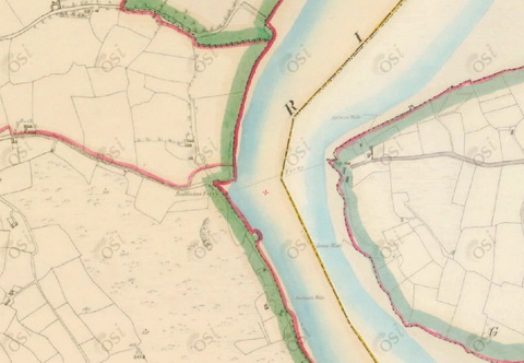
Ballinlaw ferry (OSI ~1840)
![]()
When we travelled upriver on the Knocknagow, I was surprised to find that, as well as navigation marks, the New Ross port authority had provided streetlights (or what looked like streetlights, albeit with staircases attached to provide access to the fittings). I presume that the electricity supply is to power these lights.

Navigation marks and street light
The light at the quay opposite Ballinlaw seems to have had an accident.

Fallen light at ferry quay
There were small quays in many places along the Barrow: I presume that access by water was easier than access by road. This is one of two at Dollar Point. Again, electricity is supplied. There are no other buildings here.

The quay at Dollar Point

The electricity supply

Ropes in the mud

Salmon weir on the far side (shown on the 1840 OS map)
A little further upstream, Pilltown Quay has a limekiln nearby. It is said that Co Wexford was short of lime, and that it was carried in from Kilmacow in Co Kilkenny, which is near the Suir. The Knocknagow may have been in that trade in her early years.

Pilltown Quay on the east bank with cottage and limekiln
I can’t remember exactly where the next two photos were taken, but they were twenty minutes after Pilltown, and about forty-five minutes from Barrow Bridge.

Sunlight on the eastern shore. And sixteen seconds later …

… a hill appears
About fifteen minutes later, we passed Annaghs Castle, which is on the west bank a little below New Ross.

Annaghs Castle on the west bank
After that we were in the suburbs of New Ross, as it were.

Houses on the east bank below New Ross
New Ross
This massive pontoon was moored along the east bank: I left my shelter (it had been raining) to photograph it at 1855.

Large pontoon on the east bank below New Ross
The port of New Ross is (naturally) below the bridge; there were two ships in when we passed by.

A ship on the west bank

A ship on the east bank. I don’t fancy using that lifeboat to abandon ship

Tug on the east bank
The Three Sisters Marina, run by the town council, is now on the east bank above the port but below the Dunbrody (qv) and the bridge. I took this next photo because the small sailing boat is a Privateer: we owned one, which was our first boat with a roof. According to this website only 80 were made.

Privateer in the Three Sisters marina

NB Earnest leaving the Three Sisters marina in the rain, heading for Carrick-on-Suir. Note the extended exhaust pipe
The Dunbrody is a replica of a mid-nineteenth-century barque, moored in New Ross as a tourist attraction.

Dunbrody at night

Dunbrody in Waterford

Dunbrody in New Ross (2009)

Dunbrody in New Ross (2009)
By 1911 we had passed through the bridge in New Ross. You can just see the Dunbrody downstream on the left.

Through the bridge in New Ross
Just above the bridge, on the west, is the New Ross Boat Club.

New Ross Boat Club on the west bank above the bridge
The current bridge replaced an earlier version, which was slightly further upstream. This photo, taken in 2009, shows the site of the old bridge looking upstream …

The site of the old bridge
… while this one looks downstream to the new bridge. The vessels are the Rocksand, formerly part of the Dowleys fleet on the Suir which you can read about here, and the St Ciaran, formerly based on the Shannon (and before that, as the Wroxham Belle, on the Thames), which you can see more clearly here. They operate the Galley Cruising Restaurant service.

Looking from the old bridge to the new
This shot was taken a little further upstream, looking slightly downstream to the town, and the next one slightly further up again.

The east bank 1

The east bank 2
We were back into the realm of nature by 1916.

The east bank 3
Ferrymountgarrett and Ballyanne
Eight minutes upstream of New Ross bridge is a disused railway bridge: the line once linked the Waterford–New Ross line (now no longer with us) to the Dublin–Wexford line.

Old railway bridge above New Ross
Seven minutes after that, and about an hour and a half from Cheekpoint, we met the River Nore entering from the left; our route was to the right.

The confluence of the Nore (to the left) and the Barrow (to the right)

Heading up the Barrow
At 1935 we saw Ferrymountgarrett Bridge, built in 1930 with reinforced concrete piers. It is called simply Mountgarrett Bridge on some maps. The longer name suggests that there may once have been a ferry here too. Note the Scherzer mechanism providing a lifting span (which has not been used for many years).

Ferrymountgarrett Bridge

Passing under the bridge

The Scherzer mechanism seen from the east bank
In a small cove on the west bank, just above the bridge, lies the Eclipse Flower, which formerly carried grain and flour for Ranks on the Shannon. It is for sale.

Eclipse Flower

Small bridge on the east bank
There are many bends in the river. We could see the abandoned Ballyanne cement plant across one of them. Lime was carried to here from Kilmacow.

The old cement plant at Ballyanne around the bend
 3_resize")
Ballyanne (photo courtesy Neil Arlidge)
We passed Ballyanne at about 1940.

Houses positioned to take advantage of the view

Boat moored on the west bank
By 2000 the light was fading, a mist was rising and the camera battery was about to give up.

Mist forming ahead …

… while it’s still clear astern. That was the last photo taken that evening
Pollmounty
Pollmounty (also given as Poulmounty and on one map as Pollymounty) is about half way between Ballyanne and St Mullins. It had a woollen mill, powered by the Pollmounty River, some distance from the Barrow.

The woollen mill at Pollmounty below St Mullins
There is a trout farm between the mill and the Barrow.

Boat on the banks of the Barrow at Pollmounty
The Pollmounty widens out where it joins the Barrow. The 1900s map shows several lime kilns at the junction; the next photo may show one of them. It was on the far side of the Pollmounty, with much mud in between, so I couldn’t get any closer.

Possible limekiln on the banks of the Pollmounty
St Mullins
In 2005 I stayed for a night at Mulvarra House Bed & Breakfast overlooking St Mullins. The bedroom had a balcony with wonderful views of the Barrow valley.

Looking downstream from the B&B (evening)
You can see why some people think the lower reaches of the Barrow are the most scenic of the main Irish inland waterways.

Looking downstream from the B&B (early next morning)

Looking upstream from the B&B (early morning)
St Mullins is a little like Gaul (albeit on a smaller scale) in that it’s divided into three parts. Uphill, away from the river, there is a nice pub (and, of course, Mulvarra House); you’ll also find St Mullin’s moat, temple, mill, abbey, church, round tower, celtic cross and well. But down by the river there is, or was, a mill, powered by a millrace fed from the Augharaud River. The mill was owned by Odlums (at least at one time); grain could be brought upriver from Waterford and carried further up the Barrow. Odlums owned the barge 118B, which they used here until the 1950s.
That’s the second part of St Mullins. The third part is the lock, which is some little distance upstream of the mill and the quays.
The next photos are taken from the second part, near the mill. The first one shows the east bank, looking downstream. Boats coming upstream can wait at the lower end of the bank, at the Steamer Hole, until the tide is high enough to enable them to cross The Scar.

Looking downstream from the river bank to the Steamer Hole
This next photo pans slightly to the right (west) from the previous shot, showing the shallows of The Scar.

Panning right (west) to The Scar
Now an upstream shot.

Looking upstream. It’s a long way to the lock

Mill buildings

The house of Douglas and Dorothy Odlum at St Mullins
We have come about 1.4 km upstream from the quay (I worked that out roughly from a map; if you have a more accurate figure for the distance, do please let me know). Here is the sea-lock at St Mullins.

The sea lock at St Mullins
And here is another of Thomas Omer’s distinctive lockhouses.

The Omer lockhouse at St Mullins
And after that we’re off tidal waters and on to the unpredictable flows and levels of the Barrow Navigation. And this is how Knocknagow, drawing four foot, got up the Barrow, where you’re guaranteed only 2′ 6″ (although admittedly there’s more around Easter, when the ascent was made).

Sursum corda
[wse/bar80]


Brian,
Nice to see the Barrow again. I see you didn’t include the Nore this time, tho I seem to remember that you’ve done it before. Are you going to add it sometime? It was great doing both that and the Suir up to Carrick this year in my barge, Watergeus.
You also mention you were coming into the Barrow – had you come from Dublin on the outside?
Chris Moss
Chris
Thanks for that. I intend to do separate pages on (a) the Suir estuary from Cheekpoint down (or rather from Hook Head up), (b) the Suir navigation from Carrick up to Clonmel and (c) the Nore. However, to be honest, I don’t yet have enough Nore photos, so it will probably be the last to be done.
We came from Wexford, on the Slaney, where our barge had been based for about thirty years, although it was originally Suir-based. We were in process of buying the barge; the deal was that the seller had to get it to Vicarstown. So he did all the navigation (I have no seagoing experience) and worked out how to reduce the draught (the barrels) but I went along for the ride. We waited for the third calm day in a row, left Wexford at 11.00am and were above the lock at St Mullins by 9.00pm.
Has Watergeus made it safely back across the Irish Sea?
bjg
Great work Brian
The derelict house in St Mullins was where Douglas & Dorothy Odlum and family lived
R remembers playing tennis in the garden, and going to parties there in the 60’s. M’s father was born in the “second part”, M’s grandad worked for Odlums.
Thanks, M&R. I’ve amended the info about the house. Hope all is well in omnia Gallia (or wherever you’ve now got to).
bjg
Does Douglas and Dorothy Odlum know that someone stole the roof off their house, lead and all!! You’d think they’d notice. :-)
After reading, listening to radio shows and studying the water ways I am going to try to relocate ti Ireland in the next few year.
If I live long enough and the American stock market comes back then we’ll be three.
As all Americans claim I have some Irish blood and I think I can prove. I thought about it years ago, I can get a tax break as a writer so there no big reason not to do it.
I’m 68 and retired Telephone man, LAN and sound system builder plus string for a few papers. Also married and had 6 children.
Burr
Burr: fáilte romhat, which means “welcome to you”. Immigration is outside my area of expertise, but there is information here. bjg
This is a wonderful report of the River Barrow, I love it!
Thanks, Rudi. Nice to hear from you. bjg
Pingback: Canal carrying 1846: Dublin to Waterford | Irish waterways history
would anyone have photo of the old ferry boat that serviced the crossings at Ballinlaw my Grandfather his father and even further back worked it and it would be nice to have an image of it.
Hi, Tony. I haven’t seen one myself but there could be one out there. If anyone has one, or if I hear of one anywhere else, I’ll let you know. bjg
Pingback: Ballinlaw ferry | Irish waterways history
Thanks for that Regards Tony
Loved every minute of that
Thank you. bjg
Pingback: Mills on the Barrow | Irish waterways history
Good day, I was contemplating a passage from the Shannon along the Grand Canal and South through the Barrow River through the St Mullins lock and thence onto the sea at Waterford. My vessel will be drawing around 0.9 mtrs although I may be able to reduce it slightly with endurance consideations. In your opinion would this transition be a viable option given the varied shallows of the Barrow. Is there a best time of the year for more UKC?
Regards
Liam Saxton