In June 1815 The Literary Panorama and National Register reviewed the Third and Fourth Reports of the Commissioners appointed to enquire into the Nature and Extent of the several Bogs in Ireland and the practicability of draining and cultivating them. Appendix 5 of the Third Report was Richard Brassington’s survey of a “District on the River Barrow, in Kildare and King’s County”.
The Panorama had previously written about
the mischief arising from impediments thrown across rivers, and streams; such as mills, weirs, for taking fish, &c.
It found in Mr Brassington’s report
a remarkable instance in proof of the evils attendant on such structures.
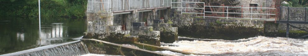
The structures in question were weirs across the Barrow, north of Athy, supplying the mill at Bert on the east bank and that at Miltown on the other. Although in an “imperfect state,” they kept “the water of the Barrow three feet above its natural level.” The Bert mill was in ruins; the other was let for £50 a year. Had the Bert mill been in good repair, its rental would have been the same, making a total rental of £100 a year. At sixteen years’ purchase, the two mills were worth a maximum of £1600. If they were bought out, the weirs could be demolished and the waters of the Finnery, which flowed into the Barrow from the east upstream of that point, would then be unable to flood the surrounding land, even when their flow was increased by draining the bog through which the Finnery flowed. Without floods, the value of the land would be increased, and draining the bog would enable land to be reclaimed:
When these matters are considered, and also that, by reclaiming the bog, employment would be afforded to the industry of the poorer orders of the people in the neighbourhood of the bog, and that the salubrity of the air would be greatly improved thereby; topics which can never be considered irrelative to the discussion of the expediency of any public undertaking, I conceive that it is extremely desirable that this bog should be reclaimed, and indeed all the other bogs in the district.
The Commissioners’ focus was very much on reclamation rather than on the use of turf as fuel; the Panorama correspondent supported this approach:
The processes recommended for improving these bogs are various: drainage is the leading feature of them all. The idea of converting the drains necessary for that purpose, in some places, into navigable canals, is happy. The system of drains in others is judicious.
On the Ordnance Survey map surveyed in 1837, published in 1839, the Finnery is shown as splitting in two just before itflows into the River Barrow; one of the branches is straight and might be artificial. Then, moving upstream, the Finnery bends in a natural-looking way until it reaches Cloney Bridge, where it flows under the Monasterevan–Athy road (R417).

Cloney Bridge on the R417; the Finnery flows beneath it

The Finnery from Cloney Bridge looking towards the Barrow
Upstream of the bridge, it turns sharply to run straight north, alongside the road.

Looking south along the Finnery with the R417 alongside
It passes under another bridge (called the Black Bridge on the 1908/9 OS map) on a local road leading to Boherbaun and Cloneybeg.

The bridge on the local road doesn’t seem to be navigable any more
Shortly afterwards, and still moving upstream, the Finnery turns NNE; just above the bend is what looks very much like a winding-hole/turning point. It soon turns NE towards the bogs (now largely replaced by woods) of those districts. It bears the legend Canal to bog; those words also appear after a right-angle right-hand bend. There is a complex of what may be small drains; the Finnery itself reemerges on the far side of the bog. Further drainage work was undertaken in 1931.

The Finnery looking NNE towards the bog at Boherbaun
It seems likely (but I cannot be certain) that the Finnery, a substantial watercourse, was both a drainage channel and a navigation, carrying turf from the bog, probably to Athy. I would welcome further information about the Finnery.

