
In March 2015, on a visit to the (small but good) Waterford County Museum in Dungarvan, I read this:
In 1843 Sir Richard Musgrave was instrumental in promoting the Blackwater for commercial/tourism purposes. As part of the project the River Brickey, at Dungarvan, was developed as a canal intended to connect with the River Finisk, which flowed into the Blackwater.
I had not heard of the River Brickey, as a navigation or otherwise, so I set off to investigate, by visiting the river itself and, back at my desk, by trying to find out more about it.
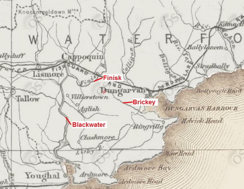
Finisk, Brickey and Blackwater (OSI ~1900)
In 1774 Charles Smith wrote about the proposal to link the Brickey to the Finisk:
There are several other lesser rivers in this county, as the Finisk, which rises near the north west bounds of the county, at Ballynamult; and, after a course of six or seven miles, empties itself into the Blackwater, to the north of Dromana.
The Bricky takes its rise near Clonkardine, not a mile’s distance from the course of the former river, and empties itself into the bay of Dungarvan, after a course of about five miles; the sea flowing up into this little river at spring tide, makes it navigable for a short way; but were the former river turned into it, this might, at a small expence, be made navigable, almost from Dungarvan to the Blackwater westwards. Another great advantage which might ensue, would be the making the whole harbour of Dungarvan much the better; for these rivers being reunited, would soon form a considerable channel, which is, at present, but very small. Though in dry weather, this little river is very inconsiderable, yet in rains, it is much increased, by a great number of small streams, which fall from the range of hills lying to the south of it.[1]
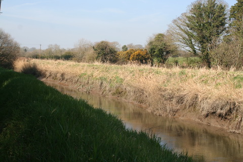
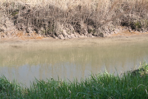
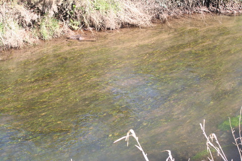
The tidal Brickey
Samuel Lewis, in 1837, described a Brickey canal project when writing about Dungarvan:
The south-western recesses of the [Dungarvan] bay are separated from the rest by a bank called Cunnigar Point, between which and the town it is proposed to throw up an embankment for the purpose of reclaiming the inner recesses of the bay. According to a survey made for this purpose by Mr Kearney, it is proposed to exclude the tides from the back strand, by making a causeway 122 perches in length, with stone walls on each side, from the garden on the east side of the churchyard to Cunnigar bank, with a roadway 22 feet wide, and sufficient openings with sluices at the bottom to discharge the surface and spring water when the tides are out.
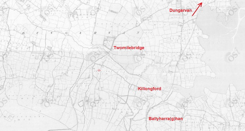
Ballyharahan, Killongford and Twomilebridge (OSI ~1840)
It is also proposed to cut a canal from the river Brickey, near Two-mile bridge, through the low grounds of Killongford, and along the southern verge of the back strand, for the purpose of discharging into the outer bay the waters of the Brickey, and the streams that flow into it from the hills on the south, and, by constructing a lock at the eastern end of the canal, of continuing the navigation for sand and other boats to Ballyharraghan, Killongford, and Two-mile bridge, as at present […].[2]

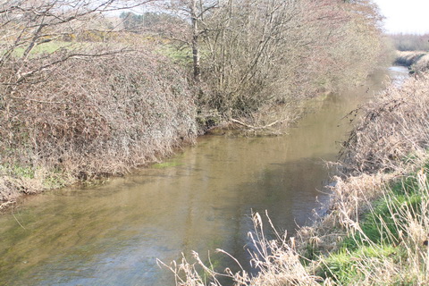
Below Twomilebridge 1
But although Lewis says that the Brickey was used by boats, and that it was proposed to provide a canal instead of the river, he was talking about the Brickey’s tidal waters downstream of Twomilebridge, whereas a link to the Finisk would have required work upstream of that bridge.
Furthermore, it is clear that the scheme outlined by Lewis was not carried out, as the Parliamentary Gazetteer of 1846 said of Dungarvan:
[…] the Brickey begins its marine expansion 1½ mile below Dungarvan, and forms a side or subordinate estuary; a large shallow strand intervenes between the estuaries [of the Brickey and Colligan], and might easily be embanked […].[3]

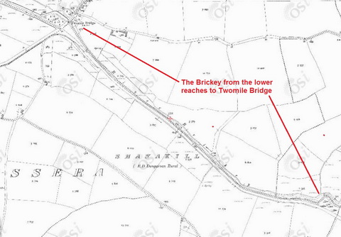
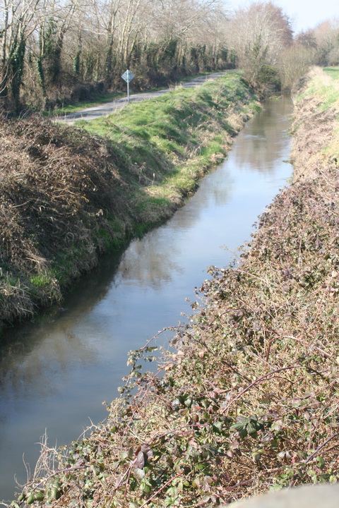
The lower reaches of the Brickey (OSI ~1840)

The lower reaches of the Brickey (OSI ~1900) showing two quays
The maps suggest that, apart from the provision of quays, little was done to alter the course of the Brickey’s tidal waters in the late nineteenth century. It’s hard to tell whether anything was done to the stretch from the tidewater upstream to Twomilebridge: the course seems pretty much the same on the two maps that follow the next photo.
Below Twomilebridge 2

Below Twomilebridge (OSI ~1840)
Below Twomilebridge (OSI ~1900)
Below Twomilebridge 3
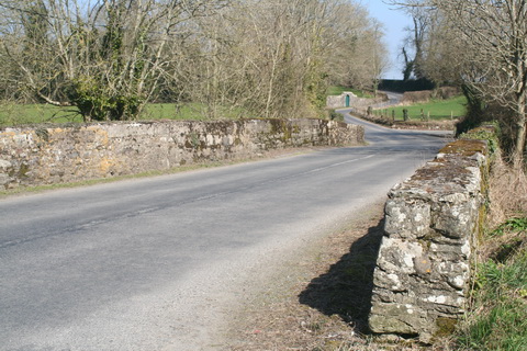
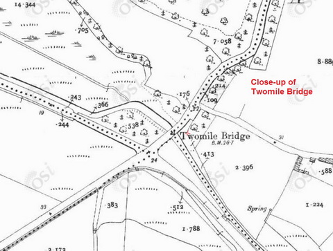
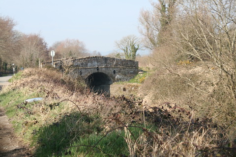
Twomilebridge

Twomilebridge (OSI ~1840)
The bridge at Twomilebridge is shown on the 6″ OSI map of around 1840, although I don’t know whether it has been changed since then.
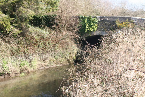
Twomilebridge
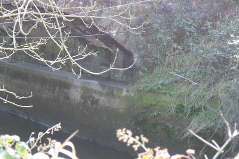
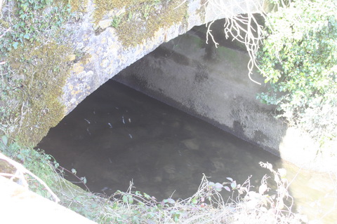
Twomilebridge: under the arch
The bridge has a second arch over the land on the northern side of the river. Having neglected to arm myself with a flame-thrower and a machete, I could not get near enough to measure the arch; indeed I could barely see it. I wondered whether it might have been intended to span a towpath (as with some Suir bridges), but the road (which becomes a track) is on the south side of the river.
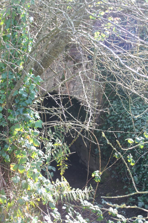
Twomilebridge second arch
The OSI map isn’t sufficiently detailed to show the second arch, but it is conceivable that there is a path along the north bank. Again, it is conceivable that small boats, carrying sand, could have been manhauled, with the tide, as far as the bridge.
Twomilebridge (OSI ~1900)
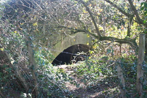
The 25″ (~1900) OSI map also shows a second, unnamed bridge a little upstream of Twomilebridge. I do not know who built it, when or for what purpose.

Twomilebridge and a second bridge (OSI ~1900)
The unnamed bridge
Its river arch
It too has a second arch; I could see only the top
This unnamed bridge too has a second arch over the land on the north side of the river. The ~1900 map shows nothing that looks like a path, track or road connecting the two bridges on the north bank; the track is on the south bank.
I would welcome more information about both bridges, especially about the second arches and about the name, age, constructor and purpose of the second bridge. If you can help, please leave a Comment below.
Above Twomilebridge
Of the Brickey itself the Gazetteer wrote:
[…] Its entire length of run is between 14 and 15 miles. Much of its valley is broad and verdant; and so near does the stream approach the Phinisk, in the vicinity of Cappoquin and for 2 or 3 miles below, that the valley almost blends with that, not only of the Phinisk, but of the Blackwater itself. The Brickey, though small in dry weather, is much swollen during rains; it is always navigable, over a short distance, in spring tides; and — as was suggested nearly a century ago — it might, at small expense, be made to receive the Phinisk, and be rendered navigable almost to the Blackwater.[4]
It seems, then, that by 1846 (or at least whenever the Parliamentary Gazetteer went to press) nothing had been done about the scheme of linking the Brickey to the Finisk. Although I don’t know exactly when the sheets covering the Brickey were surveyed, the online Ordnance Survey maps support that conclusion: the 6″ map (~1840) shows a winding river above Twomilebridge whereas the 25″ map (~1900) shows smooth curves and a new bridge upstream of Twomilebridge.
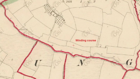
The winding course of the Brickey (OSI ~1840)
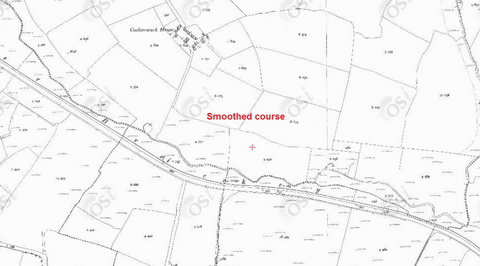
The smooth curves of the Brickey (OSI ~1900)
The Musgrave connection 1
There is further evidence that no work had been done by the end of 1842; this letter, signed only by F, Dungarvan, appeared in the Waterford Chronicle:
Sir — A letter appeared in your paper of the 7th, which probably would have passed unnoticed, had I not looked at the bottom and observed it signed “Richard Musgrave”, a name which must command respect, coming as it does from an individual whose opinions must have always great weight. I am sure his views will meet the concurrence of every intelligent gentleman, and none more so than so enlightened a nobleman as his Grace of Devonshire, who will give his countenance to an undertaking so feasible and beneficial as rendering the Blackwater communication more navigable to Mallow.
I had nearly forgot the object I had in view, to call the attention of the worthy Baronet to another matter equally useful, and partly already commenced, by the new road and clearing of the Bricky river, I mean by continuing this work and connecting this river with the Phenisk, and I cannot better explain it than by quoting the very words of Smith, in his history of the County Waterford, nearly 80 years ago. […][5]
Such is the statement of Smith 80 years ago, and the wonder is, it has been so long overlooked; the late Mr John Musgrave, at his own expense, led the way by a new road through his own property and along the Bricky; the new road now in progress to Knockmoyne, from Dungarvan, will complete thus far; and would not the consideration of the remaining part to the Phenisk, be worthy of the patronage and exertions of Sir Richard Musgrave, as if undertaken by him there would be no doubt of success, as his name and character would be a sufficient guarantee to the most selfish, that the object undertaken would be deserving of support.
F, Dungarvan, Dec 10, 1842[6]
Knockmoyne may be Knockmoan. I do not know what road John Musgrave built or which road was “the new road now in progress to Knockmoyne”.
Sir Richard Musgrave was active in attempting to improve the navigation of the Blackwater but I have found no evidence to show that he took any interest in the Brickey. I have been unable to find anything to support the contention of Waterford County Museum that
In 1843 Sir Richard Musgrave was instrumental in promoting the Blackwater for commercial/tourism purposes. As part of the project the River Brickey, at Dungarvan, was developed as a canal intended to connect with the River Finisk, which flowed into the Blackwater.
There are two aspects for which I have found no evidence:
- that Sir Richard Musgrave, the third baronet, had some connection with the development of the Brickey
- that the Brickey was developed as a [navigation] canal, in 1843 or at any other time.
Of course the fact that I have found no evidence does not mean that it doesn’t exist: my searches have been online and it may be that Waterford County Museum had access to paper records that support its contention.
Local lore
The belief that the Brickey was a navigation is not confined to Waterford County Museum. For example, geocaching folk say:
The Brickey River is known to locals as the canal and you can see why, you will be walking along a towpath.
The river was dredged as far as Knockmaun Castle in the 19th Century as part of a proposed canal which was to connect with the Blackwater, but the project was never finished.
And there are several mentions, eg this one, of a walking route:
This is the longest trail in this site. The first section is on a grassy but solid road along the banks of the Brickey River and ends at the ruins of Knockmaun Castle. […] The river was dredged as far as the Castle in the 19th Century as part of a proposed canal which was to connect with the Blackwater, but the project was never finished.

Things golfers believe: that intruders willing to clamber down one bank, wade across a river and clamber up another bank will be deterred by a sign
On the other hand, some golfers believe that the Brickey, like their golf pitch, is “natural”:
Like Tramore, this is a driver’s paradise. The variety of holes, both in terms of beauty and difficulty, will keep you excited all day and standing up on the next tee box never disappoints. The 12th, 14th and 15th run alongside the River Brickey, which is as natural and peaceful as the course itself. It warms the heart.
Given that the Brickey was clearly improved at some point in or after 1846, the golfers’ view may not be well founded.
Along the banks

Some features of the Brickey shown on the ~1900 OSI map
“Though in dry weather, this little river is very inconsiderable …” [Smith]
“… , yet in rains, it is much increased, by a great number of small streams, which fall from the range of hills lying to the south of it.” [Smith] One of the inflows

A back drain

Fierce wild beasts
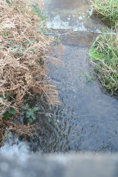
The river is very shallow

“Natural” grassland on the north bank

I found none of the footbridges shown on the map, but this now-disused bridge below Drehidatogher may have replaced one of them
Who did what when?
It is clear that the lower, tidal reaches of the Brickey were used by boats: apart from Samuel Lewis’s statement, we have the fact that the 25″ Ordnance Survey map of ~1900 shows two quays at Killongford. Boats might very well have been hauled further up the river, either before or after the improvements to the channel; we know that drainage channels elsewhere, eg the Ballycuirke Canal, were used for carrying, even if there was no navigation authority and thus no record of the goods carried.
But I found nothing in the British Newspaper Archive, which includes many Irish newspapers, to show that the Brickey was improved as part of a navigation scheme or that it was used for carrying. Furthermore, I found no record in any source of any navigation improvement scheme being carried out. Indeed it would have been surprising had such schemes been implemented in the railway age — unless of course they were amongst those sponsored by the maverick W T Mulvany.
I did, however, find records of drainage and reclamation schemes.
The Board of Works 1846–1850
The Brickey is mentioned in House of Lords sessional papers on Arterial Drainage (Ireland) for 1852[7] and in the fifteenth, sixteenth, seventeenth, eighteenth and nineteenth reports of the Board of Public Works in Ireland, which cover the years 1846 to 1850.[8]
It seems that drainage (not navigation) work on the Brickey was approved by HM Treasury at that time. Works on seven miles of the river were expected to drain 827 acres of land. The works were to cost £2947; a public loan for that amount was sanctioned and the first £1000 was transferred from the General Loan Fund. It was estimated that the works could be completed within one year.
However, work had not begun by the time the Treasury ordered a halt to new schemes and the £1000 was transferred to schemes in the Borrisokane (Co Tipperary) and Cahore (Co Wexford) districts. The improvements to the Brickey were not made in the 1840s.
The Dungarvan Harbour Embankment scheme 1858–59
The Brickey next came to public attention in the late 1850s when a company proposed to reclaim land in Dungarvan Bay.[9] The scheme had some resemblance to that described by Samuel Lewis in 1837 and it would have involved diverting the course of the tidal Brickey below Killongford Bridge:
Inasmuch, as the River Brickey came down where they [the promoters] proposed to raise the embankments which would be necessary, they intended to make a diversion of it through the Spit, the cost of which work would be about £2300. The promoters also proposed to make a bridge over the Brickey, connecting the Cunnegar Spit with the main land, at an outlay of £600.[10]
The proposal was not universally welcomed and, when parliamentary approval was sought, the Court of Admiralty commissioned George Hurwood, an engineer from Ipswich, to conduct an inquiry. As part of that he convened a lively meeting of ratepayers and inhabitants of Dungarvan; so many people turned up that it had to be moved to a larger room.[11]
During the proceedings Mr Nagle, of the promoters’ agents Treacy & Nagle of Cork, said
Of course, the promoters will be bound to confirm to such conditions as the Admiralty may impose for the improvement of the port, and the navigation of the Brickey.[12]
However, that tells us nothing about whether there was any navigation above the tidewater — or about whether there had been any work to improve the navigation.
Hurwood concluded, and the Admiralty agreed, that the proposed reclamation would damage the deep-water channel into Dungarvan and the work did not proceed.[13]
The Brickey drainage works 1867–71
I have found evidence of only one completed engineering scheme on the Brickey in the nineteenth century [which is not to say that there weren’t others].
NOTICE TO CONTRACTORS
BRICKEY DRAINAGE DISTRICT, COUNTY WATERFORDThe Board of the above district will, at their meeting on the 4th day of September next, proceed to consider Tenders from competent Contractors, for the completion of the Drainage Works of the above District, as approved of by the Board of Works, and set forth in Maps and Plans now in the custody of Richard W Robert, Esq, Civil Engineer, Office, Dungarvan, Secretary to the Board, to whom such Tenders must be addressed.
Personal attendance of Contractors will be required and security given for the due fulfilment of Contract.
JOHN QUINLAN, Chairman. August 20th, 1867[14]
It may be that no satisfactory tender was received on time because much the same notice appeared in the Waterford News three weeks later, this time saying that tenders would be considered on 18 September 1867 (and giving the engineer’s name as Richard U Roberts).[15]
By 1870 the drainage work on the Brickey had been completed and the final award had been made, repayable by half-yearly instalments over 22 years.[16] The Commissioners of Public Works had held a meeting in the Court House, Dungarvan, on 13 July 1870 to hear any objections to the draft final award.[17]
Mr Murphy and some others objected, inasmuch as the benefit which they derived from the work was not as great as was anticipated, and that the charge on their lands was excessive. Mr Commissioner LeFanu reminded the meeting that the work under consideration was arterial drainage only, and that it would be impossible to speculate upon what benefit would be derived until the proprietors had thoroughly drained their lands, which they were now enabled to do.[18]
I have seen no details of the 1860s works and I cannot say, therefore, whether those works gave us the Brickey as it is today. However, I have found no mention of any other nineteenth century works. If such works were carried out, I would be grateful to hear from anyone who knows about them: please leave a Comment below.
The Musgrave connection 2
Sir Richard Musgrave was involved in the Brickey drainage works of 1867–71. In August 1868 he announced the holding of an election for new members of the Brickey Drainage District board;[19] in September he announced that these persons had been elected:
The Lord Stuart de Decies
The Lord Hastings
The Honorable George Colley
Ambrose Congreve Esq
Edward Odell Esq
John Ussher Esq
Denis Foley Esq
Sir R Musgrave Bart.[20]
In August 1870 he again gave notice of a meeting to be held on 1 September 1870 to elect members of the Board[21] but on 12 September B Deane, Relieving Officer, gave notice that he would hold the meeting, which had been postponed, on 30 September instead.[22]
However, this Sir Richard Musgrave was the fourth, not the third, baronet. The third, the one who had promoted navigation on the Blackwater, died in July 1859.[23] It may be, though, that this is why the name of Sir Richard Musgrave is associated with improvements to the Brickey, even though they were drainage, not navigation, works and were carried out in the 1860s, not the 1840s.
Drehidatogher
I followed the Brickey only as far upstream as Drehidatogher.

Drehidatogher (OSI ~1840)

Drehidatogher (OSI ~1900)
The bridge from downstream

There is a surfaced road along the bank from Drehidatogher to Knockmoan

Looking downstream from the bridge

The upstream face of the bridge, which has only one arch
Visiting the Brickey
The N25 crosses the estuary of the Brickey at Killongford Bridge. Just south of that is a turning to the west; it soon comes close to the Brickey and follows it to Twomilebridge and the unnamed bridge beyond it. From there on there is an unsurfaced track to the next bridge, Drehidatogher. That was as far as I went, but there is a short further stretch of surfaced road from there to Knockmoan bridge.
The road upstream of Drehidatogher
Of the unsurfaced track, the geocachers say
The walk that will take you to the cache is flat; appropriate footwear should be worn, as it will get muddy following wet spells.
That may well be so. The ground was dry when I was there but, of course, I drove instead of walking. The ruts caused no problem to my 4WD (which isn’t the sort of hard-core vehicle that drives up the sides of mountains).

Getting the hump: a car with low clearance might run aground on some of the culverts
However, the culverted inflows could be difficult for any vehicle that doesn’t have good ground clearance. There are few passing places. And vehicles are likely to get their paintwork scratched.
Envoi
I would be glad to hear from anyone who has evidence about the history of the works on the Brickey and on its use as a navigation. Please leave a Comment below.
Sources
[1] Charles Smith MD The Ancient and Present State of the County and City of Waterford containing a natural, civil, ecclesiastical, historical and topographical description thereof (3rd ed, ed Donald Brady) Waterford Co Council in association with Waterford City Council 2008
[2] Samuel Lewis A Topographical Dictionary of Ireland comprising the several counties, cities, boroughs, corporate, market, and post towns, parishes, and villages, with historical and statistical descriptions; embellished with engravings of the arms of the cities, bishopricks, corporate towns, and boroughs, and of the seals of the several municipal corporations; with an Appendix describing the electoral boundaries of the several boroughs, as defined by the Act of the 2d and 3d of William IV S Lewis & Co, London 1837
[3] The Parliamentary Gazetteer of Ireland, adapted to the new poor-law, franchise, municipal and ecclesiastical arrangements, and compiled with a special reference to the lines of railroad and canal communication, as existing in 1844–45; illustrated by a series of maps, and other plates; and presenting the results, in detail, of the census of 1841, compared with that of 1831 A Fullarton and Co, Dublin, London and Edinburgh 1846
[4] ibid
[5] Already quoted above
[6] Waterford Chronicle 31 December 1842; also in Southern Reporter and Cork Commercial Courier 29 December 1842
[7] The Sessional Papers printed by order of the House of Lords or presented by Royal Command in the Session 1852 (15 & 16 Victoriae) Vol VI
[8] HMSO 1847 to 1851 respectively
[9] Waterford Mail 27 and 30 November and 2 December 1858
[10] Cork Examiner 23 March 1859
[11] ibid
[12] ibid
[13] Cork Examiner 6 April 1859
[14] Cork Examiner 31 August 1867
[15] Waterford News 13 September 1867
[16] Thirty-ninth Report from the Board of Public Works, Ireland: with the appendices, for the year 1870–71 HMSO, Dublin 1871
[17] Waterford Mail 13, 21, 24 and 27 June 1870
[18] Cork Examiner 16 July 1870 and Waterford Mail 19 July 1870
[19] Waterford News 14 August 1868
[20] Waterford News 11 September 1868
[21] Cork Examiner 17 August 1870
[22] Cork Examiner 13 September 1870
![]()
[wwse97]


Is it the Canty Bridge you are referring to? I live alongside it…