
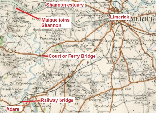
The River Maigue [locally pronounced Mag, I believe] flows through the picture-postcard village of Adare and, after many bends, joins the Shannon Estuary on its southern shore downstream (west) of Limerick. Some work to improve the river was undertaken as early as 1720 but it doesn’t ever seem to have been a very important navigation. The Directors-General of Inland Navigation did some work from 1815 onwards, installing an opening bridge on the coast road (now the N69) at Ferrybridge, between Clarina and Kildimo. The river never had any locks.
The Maigue from Adare to the Shannon (OSI 6″ ~1840)
Here are some photos of Ferrybridge.

The east bank just below Ferrybridge (aka Court Bridge)

A cot or gandalow at Ferrybridge
At Ferrybridge, a short canal led to a drawbridge, enabling sailing vessels to pass up or down the river without lowering their masts. The OSI 25″ map (~1900) shows the layout.
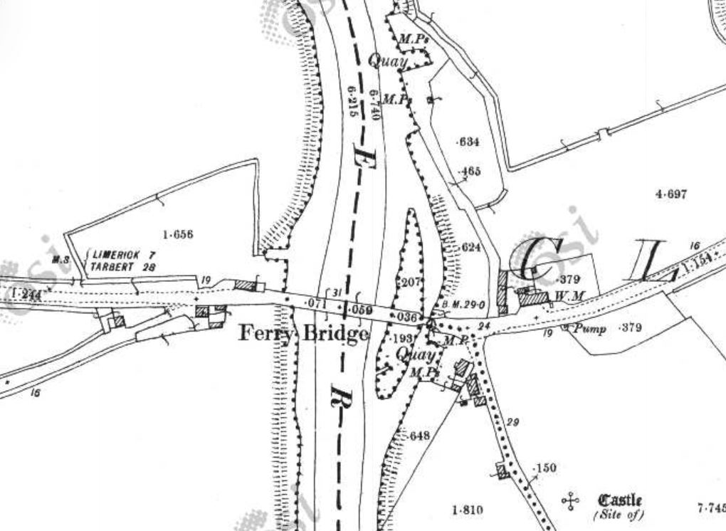
Ferrybridge (OSI 25″ ~1900)
In 1837 the Shannon Commissioners recommended that only minor works were warranted as only turf boats used the river and there was a good road from Adare to Limerick. Then, after independence, the new state reviewed its inland waterways in 1923 and concluded (inter alia) that the Maigue’s drawbridge arch could be replaced by a fixed arch: it had not been opened for many years and anyway most boats were too wide for that arch and had to use one of the fixed arches (presumably the central one). (Info from Ruth Delany The Shannon Navigation The Lilliput Press Dublin 2008)
In 1925 one Seamus O Leadain asked the Minister for Industry and Commerce
… if he can state what steps are being taken to clear the bed of the River Maigue to enable vessels to navigate the river as far as Adare, and if he is aware that at the present time vessels are unable to proceed to Adare owing to the channel being silted up.
The Minister for Finance, Ernest Blythe, said that
The Maigue navigation from Adare to the River Shannon is in the charge of the Commissioners of Public Works. No representations have been made to those Commissioners recently as to the need for dredging; and no dredging has in fact ever been carried out by them in the river (which is tidal), except at Ferry Bridge, about 3½ miles from Adare. I understand that there has been practically no traffic on this navigation for many years past.
Perhaps the prospect of having to spend serious money on the Maigue prompted the Commissioners to advocate abandonment of the navigation in 1927 (see below).

The bridge at Ferrybridge
The bridge has a pub at each end.

One of the pubs
At least as far upstream as Adare, the Maigue is heavily embanked, with sluices here and there. The confluence with the Shannon is said to be tricky to navigate, with shifting sand banks. The 1840/1844 OS maps show osieries here and there along the river.
The next three photos show part of the embankment and the river below Adare, to give an idea of the scenery.

Stile leading to Maigue embankment

The river looking calm

Sharp bend ahead
The stile shown earlier leads from the area of the trees on the left bank in the next photo. They mark the location of the quay.

The quay 1
Here’s a close-up.

The quay 2
And here’s a view from the downstream side.

The quay from downstream
The quay now serves as a small car-park, used inter alia by anglers heading down the embankment. It is a short walk from the centre of Adare.
Even when you’re standing on the quay, it’s hard to make out its former purpose …

Looking down from the top of the quay wall
Looking down from the top of the quay wall
… although the bollards are a bit of a give-away. The white circle in the foreground is the top of one bollard and there’s another to the right of the furthermost car.

Bollards
Here are some other artefacts.

An artefact

Another artefact

A depth-gauge
But the really interesting thing about this quay is that it is not shown on the Ordnance Survey map (surveyed in 1840, published in 1844), although a small quay [Mack’s Quay, according to the second set of Shannon Commissioners] is shown a little way downstream and on the far side of the river. Nor is this quay shown on the Griffiths Valuation map published between 1847 and 1864, although a possible reason for the existence of the quay is shown by Griffith (available free on Ask about Ireland).
The early maps show that the harbour for Adare was not on the river itself: it was at the end of a short canal that started a little way upstream from the quay and that ended near the ruins of the Trinitarian Abbey. You can see it on the ~1840 OSI map (Historic 6″).
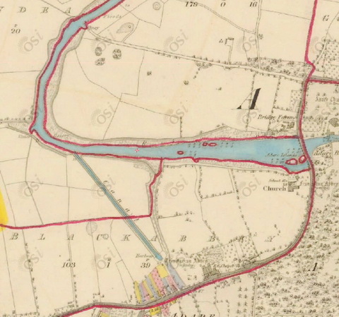
Adare canal (OSI ~1840)
It seems that the harbour was around here ….

Location of the old harbour …

… at the Adare Iron Works
So why was that harbour replaced by the new small quay? One of the earlier photographs gave a clue:

A clue
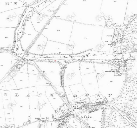
The bottom of that photograph shows the parapet of this bridge:

The railway bridge
The line from Limerick to Foynes was built (per Wikipedia) between 1856 and 1858. It had a picturesque station in Adare.

Adare railway station
Unfortunately the bridge crossed the Maigue at a low level downstream of the entrance to the old canal. I suspect that very few boats could have got under the bridge; perhaps the railway company had to build the new quay in compensation. I have so far found no information about its construction, so I would welcome information (use the Comments facility).
You can still see the line of the canal on the ~1900 map (Historic 25″) and the modern maps (where it has become a road), with the newfangled railway cutting across the river below the mouth of the canal, depriving turf boats of access to the canal harbour.
Adare canal (OSI ~1900)
![]()

The railway bridge from upstream
The railway bridge from upstream
The navigation authority
I thought for some time that the Maigue navigation might still be open and that the Office of Public Works might still be responsible for it. That was because I hadn’t been able to find evidence of official abandonment of the navigation and, when I asked the OPW, it couldn’t find it either.
However, the learned Mike Clarke had actually given me the answer, amongst much other material from the National Archives. File 2003/5/114 covers the abandonment, between 1929 and 1933, of the Maigue, the Boyne Navigation, the Louth Canal [?] and the Broadstone Branch of the Royal Canal.
On 6 April 1927 the Commissioners of Public Works applied to the Minister for Industry and Commerce, under the Railway and Canal Traffic Act 1888, for a warrant of authority to abandon the Maigue because “such navigation is unnecessary for the purposes of public navigation”.
The material I have includes a draft, but does not include a dated and signed, version of the warrant. I cannot therefore be certain, at the moment, that the warrant was granted and the navigation abandoned, but it seems likely that that happened in the late 1920s.


This is fascinating information. My cousin Paddy Waldron forwarded it to me after your recent talk. No doubt he has told you we went around the area in June looking for the quay. Photos we took are so similar to yours. We were interested as I have a family letter stating that John Smith, My Great Grandfather, who also owned Adare stores, owned the quay. (a letter only, no evidence)
We had such an enjoyable day,llooking around the river, station and small quay.
Thanks, Helen. In what years was your great-grandfather active?
Note that I think that the Office of Public Works is still the navigation authority for the Maigue. bjg
Pingback: Piracy on the Shannon | Irish waterways history
Pingback: Navigations under threat | Irish waterways history
I would like to know if you have any information on the turf boats going to adare and how much turf they brought across
Thank you
Denis O’Rourke
The 78th Annual report of the Commissioners of Public Works, for the year ended 31 March 1910, says of the River Maigue Navigation “The total traffic for the year was 150 tons, against 38 tons in the previous year. The increase is due to one or two cargoes of coal brought by a small steamer from Kilrush to Adare.” That suggests that the regular traffic was very small.
I have looked at a small number of the earlier reports; none of them gave a tonnage figure but it might be possible to deduce it from the toll figures. The earliest reports tended to give more information, but I have not looked for Maigue/Adare details in any of them.
Many of the Commissioners’ reports are available on the EPPI website; the archives are in the National Archives. From my enquiries on responsibility for the Maigue navigation, I deduce that the OPW does not retain any relevant papers on navigational issues.
bjg
thank you so much for this information, i couldn’t find this information anywhere.It is much appreciated
denis o’orourke
No problem. bjg
I see the latest bypass for Adare is back on the northside! Guess that will be the end of the turf boats to Adare…
Yes: I was tempted to ask the Office of Public Works whether, as the navigation authority for the Maigue, it intended to object to the road plan in order to keep the navigation open. But I suppose that, once Court Bridge was fixed, the turf boats were doomed. bjg
Pingback: Maigue Rivers Trust established as Community-led initiative
I walked the east bank yesterday from Adare to ferry bridge. It should be explored as a blue way fkr walking as the bank is very high and more walks are needed in this area with the current riverbank walk being far too busy.
Lee harrington.