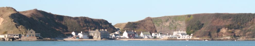
A pill is a tidal creek. The term is associated with south-western England and Wales, especially along the Severn, but it is also found in south-eastern Ireland. Along the River Suir, we find Pouldrew Pill, an unnamed pill and, of course, the Pill that leads to Pilltown (I admit to having no evidence, but I find Wikipedia’s explanation of the name Pilltown rather less than convincing). If you know of other Irish pills, do please leave a Comment below.
Brian Simpson, in a Comment on this page, drew attention to St John’s Pill in Waterford. He wrote:
Would there be any chance of listing this old waterway in Waterford City which was used by coal, sand and gravel barges up to the 1950s? The waterway has suffered badly over the years; however it is staging somewhat of a comeback with a flood relief scheme under way, clearing most of the river, and our volunteer group working to restore the old canal stretch on the Tramore road. The major issue with the river is two low-level bridges and some pipes were built across it in the 1980s, cutting much of it off to boating activity. We got a commitment from City Council that the pipes issue would be dealt with as part of the flood scheme.
I am pleased to do so. Brian’s group has a blog, with pics of kayaking on St John’s Pill (or River), and a Facebook page with the latest news. He kindly supplied me with photos of the small-boat rally on the Pill in May 2015; I’ve put them here.
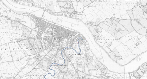
St John’s Pill marked in blue (OSI ~1900)

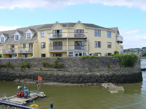
Ex-Grand Canal Company motor barge 68M at the south-eastern side of the entrance to the pill
The north-western side of the entrance to the pill
History
I have been trying to find evidence of the use of St John’s Pill for navigation, but I have had little success, and I would welcome any information that readers could provide.
According to askaboutireland, Waterford’s Great Charter Roll of 1372 shows Waterford at the top, and then:
Below the city is St. John’s Pill, a tributary of the Suir river, with three galleys and on the bank below are rabbits, brought to Ireland by the Normans as protein for the winter.
The Charter Roll is in the mediaeval gallery at Waterford Museum of Treasures (although I can’t find it mentioned on either the website or the Facebook page).

Boats in the pill 2005

Boats in the pill 2007
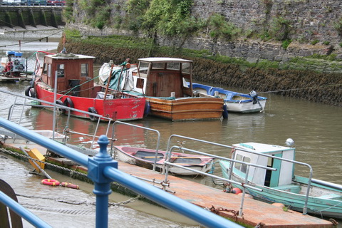
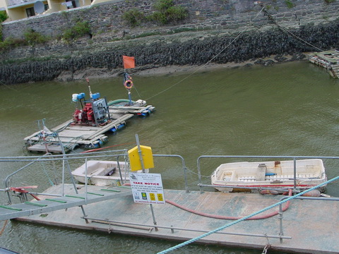
If I remember correctly, mud was being pumped out of the pill in 2007; there is a pump on the raft ahead of the two larger boats
I had a quick look through Charles Smith MD’s The Ancient and Present State of the County and City of Waterford [first published 1746; revised and enlarged edition 1774; 3rd edition 2008 edited by Donald Brady, published by Waterford Co Council in association with Waterford City Council] to see if I could find anything about navigation on St John’s Pill. I found nothing directly relevant (perhaps because of insufficiently thorough reading) but this is suggestive:
Among the other edifices, I might have mentioned an ingenious mill, erected by Thomas Wise, esq; which grinds, sifts and bolts the several kinds of meal and flour at the same time; and near to it, are considerable granaries erected, which will be both an advantage to the town, and a profit to the proprietor. It is situated on John’s River, without Bowling-green gate.
I have no map showing Bowling-green gate, but my guess is that the location was around Wyse’s Bridge. If there was a water-powered mill at that point, with all its accoutrements, that may have formed an upstream limit for navigation, at least as long as the mill lasted.
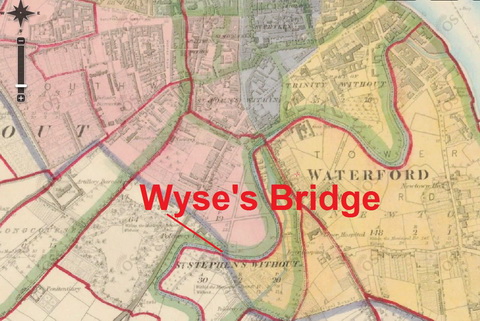
Wyse’s Bridge (OSI ~1840)
I presume, incidentally, that that Thomas Wise was a forebear of the Sir Thomas Wyse who married Napoleon Bonaparte’s niece.
The pill
The Parliamentary Gazetteer of 1846 says:
JOHN’S RIVER, a rivulet of the county of Waterford, Munster. It rises in some marshy grounds about 3 miles south of Waterford; flows northward to the Suir within the bounds of the city; and is there navigable at high water for the largest description of boats. It is crossed within the city, by two old bridges, called John’s-bridge, and William-street-bridge, and by one of recent erection, situated near the old abbey of St Catherine, and called Catherine’s-bridge.
It also says:
A rivulet called St John’s Pill runs in a serpentine course along the east side of the city to the Suir; but it cuts off only small outskirts of the streets, and, in its boldest and longest sweep, passes completely away from the edificed portion of the town. The river Suir, while passing the town, has a breadth of from 230 to 350 yards; and it pursues an east-south-easterly direction to the termination of the street called the Mall, and then slowly curves to the commencement of a south-easterly direction at the mouth of St John’s Pill. […]
On the 20th June, 1816, the royal assent was given to an Act of parliament for ‘deepening, cleansing,and improving such parts of the river Suir as constitute the port and harbour of Waterford, between Bilberry Rock and Hook Tower, including St Catherine’s, commonly called St John’s Pill, and the appointment of a pilot-office and ballast-office in the said city of Waterford.’ […]

Looking up St John’s Pill from the confluence with the Suir
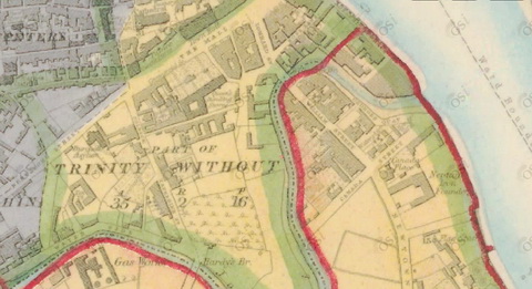
The lower reaches of St John’s Pill (OSI ~1840)
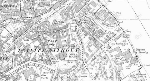
The lower reaches of St John’s Pill (OSI ~1900). Note the Neptune shipyard
So the Gazetteer suggests that vessels entered St John’s Pill from the Suir but it says nothing about any traffic up the Pill. I haven’t explored local (Waterford) sources to see what they might be able to tell us about such traffic, so I would be glad to hear from anyone who has information.
Speculation
Brian Simpson said that the Pill “was used by coal, sand and gravel barges up to the 1950s”. Such types of traffic were often little noticed. It would be interesting to know whether the cargoes were going just as far as the lower reaches or whether they went further upstream. It would also be interesting to know whether cargoes were carried down the pill into Waterford; was turf harvested from Kilbarry Bog? [Addendum: Brian Simpson says that it was not: that the bog is more like a fen or reed marsh.]
The OSI map of around 1900 shows two industries that might have used river transport.

Gas works and lime kilns (OSI ~1900)
The first is the gas works, which would have needed a constant supply of coal. It is just below John’s Bridge, which is marked as the highest point to which the tide flows. If there were enough depth under the two downstream bridges, boats could have come up with the tide, their crews equipped (as were those of many Suir and Barrow vessels) with long poles; little headroom would have been needed under the bridges.
The second industry that might have used water transport is that of the lime kilns, situated above John’s Bridge. Both coal and limestone could have come in by water; if turf was available from upstream, it too might have been used. Finally, the lime produced could have been distributed over a relatively wide area by boat.
The kilns are, as I said, above John’s Bridge. The St John’s River group have an interesting photo on their Facebook page. While that ramp could now be used for canoes, kayaks and other such small craft, I would be surprised to find that it was built for the purpose. I am speculating on very little evidence, but I wonder whether that ramp might have been designed to facilitate man-haulage (or perhaps horse-haulage) of a boat that had reached the bridge using the tide and that needed to move further upstream.
Edit: this photo suggests that only very small craft could have got under the bridge. I don’t know whether the river was always so shallow.
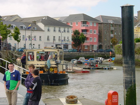
Waterford & District Boat Owners Association pontoon
Regulation
That invaluable publication The rules of the road at sea : comprising the regulations for preventing collisions at sea, 1910, and rules in force in harbour, rivers, and inland waters, with explanatory notes and observations by Hubert Stuart Moore and Norman Duncan [J D Potter, London 1922; available free online] covers Waterford, the Suir and St John’s Pill. The items relevant to the pill are these:
- orders in council of 1886 and 1887 set the limits of the River Suir as “including Saint Katherine’s, commonly called Saint John’s Pill”
- bye-laws passed by the Commissioners for improving the Port and Harbour of Waterford in 1870 did the same
- bye-law 22 said “The navigation of St John’s Pill shall not be obstructed by vessels, boats, or rafts of timber, nor shall rafts of timber be allowed to remain in the river, nor alongside the quays, unless by permission of the harbour master, deputy harbour master, or other assisstant, the period not to exceed two days.”

Vessels in St John’s Pill, waiting to settle on the bottom when the tide goes out
Where did the rafts of timber come from? Where were they going to? How were they propelled into (or out of) Waterford? Were Messrs Graves of Waterford the guilty parties at whom bye-law 22 was aimed? Their timber yard was on the Suir just downstream of the Neptune shipyard and iron works, in other words just around the corner from St John’s Pill.

The remains of the Graves quay (I think). If I remember correctly, Graves had the first newly-built Bolinder-powered vessel in Ireland, the Rose Macrone
It will be evident that this page is a long way from providing a full account of cargo carrying on St John’s Pill. There is more speculation than evidence, but I hope it may serve to stimulate interest in the subject. I will be glad to hear from anyone who can help to fill out the story; if you can, please leave a Comment below.
Addenda
Paul Clancy (see Comments below) has sent this photo “showing just a small part of the mill to the left hand side”. I am grateful and would welcome further information.

The edge of Finns Mill on the left of the photo (courtesy Paul Clancy)
Here [October 2014] is a little more information about the history of the upper reaches of St John’s Pill. And here [March 2017] is an ad suggesting that the Pill was in use in 1785 — and that flour could be carried from Portlaw via three rivers: the Clodiagh, the Suir and St John’s Pill.
![]()
[middlesuir30]


Finn’s Mill, the Pill, Waterford City.
Finn’s Mill was situated about 100 yards west of Wyse’s bridge in Johnstown up to the 50s or 60s. Michael Crow’s Furniture is now on the site of the original mill. It was a flour mill and was probably 10 stories in height. A race flowed at the back of the houses on the west side of Johnstown, (same side as Grims’s Bar) and went through the mill and exited via a tunnel which can be seen very close to the bridge almost opposite Crow’s Furniture. It is presumed the flow of the water from the race drove the machinary and grind stones of the mill. The edge of the mill can be seen on the left hand side of the photo listed below.
That’s great, Paul; thanks very much. The only thing is that the link doesn’t work for me. I’ll email you about that. bjg
The Waterside was once known as John’s Quay indicating it was probably used as a mooring place for boats, its marked as such on the Leahy map of 1834. There are four timberyards, a gas works and a salt works also shown on that part of the river. Further on past Wyse Bridge there is a channel shown connecting the river with the Manor Demesne that originally occupied the area just south of College street, I believe the Wyses used this to bring goods up the river to their estate.
Link to Leahy’s map

Thank you very much. There is certainly plenty of industry that might have used water transport and it would be surprising if it wasn’t used, but it would be nice to have more positive evidence. I’ve just looked through Peter Jordan’s 2006 Waterford Municipal Art Collection: A history and catalogue but without finding anything useful: three pics show the pill but none has any boats in it. bjg
I’m afraid there is not much evidence now for traffic on the Pill other then anecdotal. I was born in 1960 and by then I think the use of the river for any purpose had ceased, it has been sorely neglected since then up until very recently when some clean up has begun.
I came across another description of John’s River in Joseph Hansard’s 1870 History of Waterford,
“John’s River, which falls into the Suir, within the bounds of the city, has its source in the marshy lands between Waterford and Tramore, about three miles distant from the former place. It is a narrow stream until it approaches Waterford, when it is affected by the tides, and becomes, at high water, navigable for the largest description of boats”
I mentioned in my previous comment that the street known as the Waterside, between Catherine Street bridge and John Street Bridge, was once known as John’s Quay. It was known as Grubb’s Quay before that and there was a lane called Grubb’s Lane which connected it to Catherine Street. I believe the Grubbs in question were the same family as those in Clonmel who carried on a great deal of trade up and down the Suir and very likely owned some of the timberyards shown on the old maps.
A better view of the ramp by John Street bridge. The railings along the river have since been replaced by an ugly flood wall.
https://maps.google.com/maps?q=Waterford,+Ireland&hl=en&ll=52.25646,-7.110806&spn=0.001304,0.003484&sll=37.269174,-119.306607&sspn=13.870027,28.54248&oq=waterford,&hnear=Waterford,+County+Waterford,+Ireland&t=m&z=19&layer=c&cbll=52.25646,-7.110806&panoid=-sGaGIMjqv2FinH2I_nIKg&cbp=12,53.02,,1,9.42
Boats on the Pill, well imaginary ones anyway. This is a painting by an American artist, Ernest Ruckle, who is based in Waterford I believe. The scene is the Waterside.
http://www.ernestruckle.com/521.htm
Thanks for that, Paul. The ramp definitely looks too narrow, and perhaps too close to the bridge, to be a slipway, unless part of it was covered by road-widening or something.
Part of my reason for putting up pages like this one is to say that the subject of waterways and commercial carrying is of interest and perhaps even of importance, and that information about it is worth recording. If my experience with other waterways is any guide, researchers may come across passing mentions of the Pill traffic when following other topics. There might be a court report of a theft from a boat, a coroner’s account of a drowning in which a boatman helped to recover a body, perhaps even a boat glimpsed in the background of a photo that is focused on something else. If anyone does come across anything usseful, I’d be happy to add it to this page and to build up and make available a repository of all that is known.
The Grubb connection is interesting. Would that have been late eighteenth or early nineteenth century?
Thanks too for the imaginary boats.
bjg
Grubb Quay is marked as such on the Richards and Scales map of 1764, unfortunately I don’t have a link to it.
I found mention of delivery of coal by barge to Waterford Gas Works in the Gas Journal published in 1906. The article incorrectly refers to the Saint John’s Pill as the Suir.
http://books.google.com/books?id=4bAiAQAAMAAJ&pg=PA897&lpg=PA897&dq=waterford+gas+works+coal+delivery&source=bl&ots=sxplOWVKb5&sig=Pb6zBHeLvV7iCoJp8uaP8xt-LEY&hl=en&sa=X&ei=cTvnUbjNJ6_8iQKj9oD4AQ&ved=0CC0Q6AEwAA#v=onepage&q=waterford%20gas%20works%20coal%20delivery&f=false
A photo was recently posted on the Waterford History Group Facebook page which shows several barges moored at the Gasworks. I believe the photo was taken by Father Browne in the 1930’s. I’m not sure of the copyright so I hesitate to post a link.
Wyse’s Mill and Bowling Green gate according to Egan’s Guide,
“This was a mill considered ingenious in its time as it “ground, sifted and bolted” the corn at the same time. it stood on John’s River, outside Bowling Green Gate, which gate stood at the corner of Castle street crossing the Manor.”
It would have been some where around here
https://maps.google.com/maps?q=Waterford,+Ireland&hl=en&ll=52.256508,-7.112127&spn=0.00131,0.003484&sll=37.0625,-95.677068&sspn=54.621153,114.169922&oq=waterford&hnear=Waterford,+County+Waterford,+Ireland&t=m&z=19
Thank you very much. The Father Browne photo is not amongst the selection on the official website, alas.
I wonder whether Loughlin Freeman was involved in carrying coal there.
bjg
You are correct with your comment under a photo
“If I remember correctly, mud was being pumped out of the pill in 2007; there is a pump on the raft ahead of the two larger boats”
This work was being carried out by the local boat owners themselves as they could only access their boats at or near high tide due to the mud build up but due to the high workload this work eventually stopped and the boats started disappearing out of the Pill while the mud quickly returned, now there are only a small number of boats left. The pump was built by the boat owners themselves from an old tractor engine. As for your photographs of the Grand Canal Company motor barge’s, this was during the Tall Ships in 2005 when the Heritage Boat Association made the trip to Waterford for the event and came back again about 2 or 3 weeks later after they had travelled up river as far as Carrick-on-Suir for another visit, they had intended coming back again for the tall ships in 2011 but the new flood defence made it impractical to try access their boats from the bank.
Thanks very much for that, Pirate Benjamin. Sorry to hear about the problems with the mud. bjg
Thanks very much for that, Pirate Benjamin. Sorry to hear about the problems with the mud. bjg
Hi
Just to let you know there is a Piltown in south Kilkenny about 20 minutes from Waterford City. Also its spelled with 1 L.
Sharon
Thanks, Sharon. bjg
There is also a pill about 150 meters up river from the red iron bridge https://www.google.ie/maps/@52.2754665,-7.1438626,477m/data=!3m1!1e3?hl=en
Thank you. Is that what I think of as the Kilkenny Blackwater, which has (or had) some Guinness Liffey barges sunk in it? bjg
Yep, that is the one, I have also heard it called the Kilmacow Pill but I think that might be a local nickname rather than anything official, it passes under the road near Redbridge petrol station, I never knew about the Guinness Barges though.
Here’s a photo taken in 2004, long before the bridge works began. The barges were in very poor condition. There was an abandoned fishng-boat or something up there too. bjg
That is very interesting, those boats were sunk deliberately when they were no longer useful as trucks were being used to transport goods, the idea behind sinking them was to preserve them for as long as possible, on the subject of sunken boats on the river there is a 50 Meter approx ship opposite the mouth of St Johns Pill. This vessel is believed to be the cargo ship the S.S. Harvard, dating from 1870. Scroll down to the 3rd & 4th pictures on this report and it shows the sonar image of the ship. http://infomarupdates.blogspot.ie/2011/06/rv-kearys-first-infomar-survey-leg-of.html
The two Guinness boats in the Kilkenny Blackwater were, I believe, used in Cork for transporting stone or something after Guinness ceased carrying on the Liffey. Then (IIRC) someone bought them but was unable to get funding for whatever he wanted to do, so he abandoned them. Barges in fresh water are preserved, as you say, but there is too much salt in the Blackwater. Some background info here; we brought Tim along when we went to photograph them. The sonar is very interesting; thank you. bjg
Came across this interesting piece regarding sand barges unloading at the Waterside next to John’s Bridge,
“They lived on the barge, or lighter, as they were sometimes called, and during the hours of daylight, they would single-handedly shovel sand into the hold of the barge until she was full – I think they held up to sixty or seventy tons – which took almost two weeks. They then cast off on full tide, and poled the barge down river in stages whenever the water was slack. When they got to the Scotch Quay, they poled their way up the tributary, through the park, and moored at John’s Bridge on the Waterside, and there they would unload on the quayside, which meant a week or ten days shovelling again. Incidentally there was a limekiln just at this point. The river was, however, navigable for lighters up to where the Spencer limekiln was situated. This was a strategic advantage for that kiln, as limestone – the raw material – as well as fresh-water sand could be delivered onto the actual site of the lime works.”
https://smorgasbordinvitation.wordpress.com/tag/ireland-1930s/
Thank you very much for that: very interesting in several respects. bjg
Looking Forward to walking around these sites tomorrow .enjoyed the history regards james .
Pingback: Improvements at St John’s Pill, Waterford | Irish waterways history
A “handsome testimonial inscribed on vellum” was awarded by the Royal Humane Society to A G Clampett for saving Wm Reade who fell into the river Pill, into 20 feet of water (Leeds Mercury, 20 Oct 1876, p12). As Arthur George Clampett was born ca 1858 at Waterford City, I assume this refers to St John’s Pill which you address in such wonderful detail here. Thanks, Jean, an amateur genealogist.
Thank you. There are some other pills in the area, for instance at Piltown, but I doubt if it would have been 20 feet deep. bjg
Terry O’Regan; Thursday 21 January 2016
I spent my childhood in the 1950’s living in the Gasworks on the Waterside, my father Joe O’Regan was manager of the Gasworks, having started work there as office boy in the early 1930’s, he told me that he remembered the coal being carried by barge up the Pill from ships in Waterford Harbour, he spoke of the coal being unloaded by hand using ‘hods?’ on men’s backs (I envisaged them as baskets. He seemed to describe this as happening between the ‘lorry’ bridge and a lovely iron pedestrian bridge. Further down river below the lorry bridge there was a small crane-like mechanism and the brickwork in the vicinity of same had a pattern than suggested there may have been a loading area at a lower level. Regarding the common name of the river I had assumed it derived from the Irish word for hole Poll, or Poul, ‘Poill’ which I believe is of Norse origin which would make sense. The slipway and steps along the Waterside section of the river certainly speaks of considerable river activity. Sadly the two Gasworks bridges mentioned above were allowed to deteriorate and are gone and the flood protection may be functional but it vandalised some wonderful cut-stone that defined the top of what must in its time have been a continuous quay wall on the city side.
That’s very interesting, Terry; thanks very much.
I recall that Tim Finnegan, to rise in the world, carried a hod. That was probably a brick hod, but I see that the word is also applied to coal scuttles. The brick type would need sides to stop the coal falling off; the domestic coal scuttles don’t look as if they would be very efficient for unloading a barge (and they would be hard for men to carry on their backs). I haven’t managed to find anything useful on the internet.
On the word Pill, it is used in the same sense around the Severn and Avon, where I suspect it is from Welsh, and elsewhere in south-western England. I haven’t been able to find a good account of its origin, but it may be a word that was used in both branches of the insular Celtic languages.
bjg
I can´t give you any info. re. coal barges at the gas works, but i can vividly remember the coal and sand shipments at the pill behind William´s Street in the 1940s. The coal was, I suppose, for the merchents in William´s Street. Was that not Morris Coals ?? There was a turnover of sand there well into the 1950s.which came in by motor barge and was usualy unloded by an onboard bucket crane. The dredger was a regular visiter to the pill not to dredge but for de-rusting and painting at low tide. The Finns (mills) lived beside us in passage road.
Owen O`Grady.
Thanks very much for that, Owen: it all adds to the picture. bjg
Pingback: A Bourne mystery | Irish waterways history
Pingback: St. John’s River: Confluence | Making memories
Adding some info on St John’s Pill. Doing some family history research recently – I came across the sad detail of an elderly relative who fell in and drowned in “John’s Pill” in the city at the turn of the last century. Perhaps ironically they came from a family with a long tradition of seafaring.
Interestingly I did not know what a Pill was and was looking the term up when I saw your blog.
Also saw there is another Pill called “Woodland Pill’ marked on the map for Waterford navigation – on the south Bank between Belview and View Mount Point. You may need to zoom in to locate.
See:
http://fishing-app.gpsnauticalcharts.com/i-boating-fishing-web-app/fishing-marine-charts-navigation.html?title=Waterford+Harbour+boating+app#13.8/52.2550/-7.0279/-26
Thank you for that. That fishing chart app is very good. bjg
Barges used John’s river to transport from the flour Mill’s at Course Ballinamona.
Pingback: The river placename Pill – a context - Waterford Harbour Tides & Tales