Kate Douglas Wiggin wrote in Penelope’s Irish Experiences in 1901:
If you want to fall head over ears in love with Ireland at the very first sight of her charms, take, as we did, the steamer from Cappoquin to Youghal, and float down the vale of the Blackwater –
‘Swift Awniduff, which of the English man Is cal’ de Blacke water.’
The shores of this Irish Rhine are so lovely that the sail on a sunny day is one of unequalled charm. Behind us the mountains ranged themselves in a mysterious melancholy background; ahead the river wended its way southward in and out, in and out, through rocky cliffs and well-wooded shores.
The rich lands in the valley of the Munster Blackwater were colonised by English settlers, including Sir Walter Raleigh, after the Elizabethan plantations. The area still has many large houses, and even a castle at Lismore, owned by the Duke of Devonshire, who also has some rights to the fishing and the bed of the Blackwater. In 1814 an earlier duke built a short canal from Cappoquin, at the head of the tidal section, to Lismore, so there are three waterways in this area:
- sixteen miles of the Blackwater from Youghal to just above Cappoquin
- seven miles of its navigable tributary the River Bride
- the Lismore Canal, which now has a page of its own here.
These waterways are not linked to other Irish inland waterways, other than by the sea at Youghal.
Navigation on both Blackwater and Bride is tidal. There were three main sets of users:
- fishermen
- various pleasure steamers and motor vessels
- schooners and other trading vessels.
The best-known trade saw coal brought in from Wales; in return timber, for pit-props, was taken out from both Blackwater and Bride. Schooners would come up with the tide, sit on the bottom while loading and float off with a high tide after loading. Schooners might take on only half a load in Cappoquin and complete the load further downriver, in deeper water. The schooners involved in this trade included:
- De Wadden, a steel three-masted schooner built in 1917 and now in Merseyside Maritime Museum. There is a photo of the De Wadden loading at Killahala here with other photos of Dromana

De Wadden in Liverpool (October 2011)
- the recently-restored wooden three-masted schooner Kathleen & May

Kathleen & May in Liverpool (October 2011)
- the ketch-rigged flush-decked trow Jonadab, whose remains are in the Purton boat graveyard near Sharpness.
Fixed bridges at Youghal and at Camphire now block access by tall vessels to the Blackwater and Bride respectively; here is an account of the building of the old bridge in the nineteenth century.
Neither the Blackwater nor the Bride has any locks, navigation marks or navigation authority. There are said to be shallows in the Blackwater; there are also some fish weirs. Both rivers have fine stone quays as well as some lesser quays: the larger quays were probably those used for the timber trade.
I visited Tallow, at the head of the Bride, in 2006, and saw a poster for Tony Gallagher’s Blackwater boat trips on his 28′ half-decker MV Maeve. Tony’s usual trips last ninety minutes (€20 per head), but we were fortunate enough, in 2008, to contact him just before the start of his season, when he was able to give us a much longer trip all the way to Cappoquin and back. Most of the photos in this gallery were taken from the Maeve; some (of Cappoquin, the Lismore Canal and the Bride) were taken from the land.
We saw only about a dozen boats moving on the river. They included one or two jetskis and a few skiboats, but they had plenty of room and weren’t interfering with anyone. There were lots of boats moored or ashore, so clearly the river is much used.
I am grateful to Nicholas Grubb for correcting some errors and for pointing me to some wonderful photos, now here; he offers traditional houses for rental at Castle Grace near Clogheen and at Dromana on the Blackwater.

Tony Gallagher’s poster seen in Tallow in 2006

Tony Gallagher himself on his MV Maeve in 2008

The map Tony Gallagher shows to passengers

The quays at Youghal

The bay at Youghal. The dinghies, moored to a float, give some idea of the scale

The river meets the bay at Rhincrew, where the Knights Templar had a preceptory

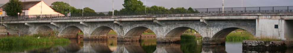
The N25 Cork–Waterford road bridge, built in 1958. The earlier bridge had an opening span

Boats moored on the east side above the bridge

The tree-covered west bank, where we saw otters on our way back down
Most of the photos on this page were taken on the day of the boat trip. Some were taken from shore early in the day, when the sun was shining, and some were taken on other visits to the area. Unfortunately, shortly after we passed the N25 bridge on the boat-trip, the sky clouded over, and photos from later that day were taken in rain or in poor light.

Clouding over

Templemichael, on the west bank, has the ruins of a fourteenth-century Geraldine castle and a later church

Looking upriver from near Templemichael

The River Glendine enters on the west side
Molana Abbey, on the west side, was originally on an island. It is rumoured that Norman leader Raymond le Gros is buried here. Note the sprat weir (for catching fish) in front of the abbey.

Molana Abbey

Ballynatray House, which has a website

Ballynatray House lodge, salmon weir and thatched boathouse

The west bank above Ballynatray
It is said that egrets nest on the west bank above Ballynatray, but I saw none of them: je ne egrette rien.

The east bank above Ballynatray

Ballynaclash Quay on the east side
On the west side, Old Strancally Castle is hidden by trees until you get quite close.

Old Strancally Castle

Ballynaclash quay again

Coolbagh quay, with vans and a canoe, also on the east side

A cottage upstream of Cooneen Quay

Further up on the east side: how nice to have boats at the bottom of the garden

The west shore still has lots of trees
Strancally Tower comes before New Strancally Castle.

Strancally Castle
Even when you’re level with it, you can’t see New Strancally castle, but you can see its pontoon.

New Strancally Castle pontoon
From upstream, you can look back at the castle.

New Strancally Castle
Here is Strancally Castle, from the Dublin Penny Journal in 1834.

Strancally Castle 1834
The navigable River Bride joins from the west. We’ll return to it later.

The River Bride
Formerly used by ferries and fishermen, Villierstown Quay (on the east side) is now popular with swimmers and jetskiers.
 formerly ferries and fishermen now swimmers and jetskiers")
Villierstown Quay

Camphire House on the west bank, originally an Ussher house
On the east bank, the collection of buildings at Dromana starts with the Rock House, built in the mid-1700s as “a sort of estate folly” at Dromana but then used as a ferryman’s house. Thanks to Nicholas Grubb for information on this and Camphire House; his own site has more information and photos about Dromana.

The Rock House
Just after that is “a neat bastion the vaults under which serve for a boat-house” (Smith 1746-74).
")
The Dromana boathouse
I am indebted to Beth O’Loughlin for the next photo, taken from above the boathouse.

Looking down from above the boathouse

Dromana House
Dromana House is built on a site formerly owned by the FitzGeralds of the Decies. Kate Douglas Wiggin wrote:
Next came Dromana Castle, where the extraordinary old Countess of Desmond was born,–the wonderful old lady whose supposed one hundred and forty years so astonished posterity. She must have married Thomas, twelfth Earl of Desmond, after 1505, as his first wife is known to have been alive in that year. Raleigh saw her in 1589, and she died in 1604: so it would seem that she must have been at least one hundred and ten or one hundred and twelve when she met her untimely death,–a death brought about entirely by her own youthful impetuosity and her fondness for athletic sports. Robert Sydney, second Earl of Leicester, makes the following reference to her in his Table-Book, written when he was ambassador at Paris, about 1640:-
‘The old Countess of Desmond was a marryed woman in Edward IV. time in England, and lived till towards the end of Queen Elizabeth, so she must needes be neare one hundred and forty yeares old. She had a new sett of teeth not long afore her death, and might have lived much longer had she not mett with a kinde of violent death; for she would needes climbe a nut-tree to gather nuts; so falling down she hurt her thigh, which brought a fever, and that fever brought death. This my cousin Walter Fitzwilliam told me.’
It is true that the aforesaid cousin Walter may have been a better raconteur than historian; still, local tradition vigorously opposes any lessening of the number of the countess’s years, pinning its faith rather on one Hayman, who says that she presented herself at the English court at the age of one hundred and forty years, to petition for her jointure, which she lost by the attainder of the last earl; and it also prefers to have her fall from the historic cherry-tree that Sir Walter planted, rather than from a casual nut- tree.

Mini-cliff above Dromana
We diverted from the main channel to go to the east of Big Island to pick up a pilot. This gave us the opportunity to look at a rare surviving example of one of the two types of Blackwater cots, formerly used for snap-net fishing, which is now banned. There are some wonderful photos of draft-net fishing at Dromana here.

Inside Big Island

Blackwater cot
Back in the main channel, we carried on towards Cappoquin, noting these quiet moorings.

Quiet moorings
After the railway bridge was built in Cappoquin, a quay was provided on the west bank below the bridge. The National Library has two relevant photos, here and here [h/t EOL].

The steamer quay

The now-disused railway bridge in Cappoquin
The older quay was at the former site of the bacon factory, now occupied by new houses. The South of Ireland Wheel and Carriage Works were nearby. Some remains of the quay are still visible and there is a slipway to the right of the houses.

The old quay
Here are some photos taken from the site of the old quay.

The bend of the river between the railway bridge (left) and the road bridge (right)

Cappoquin Rowing Club, below the road bridge

The N72 road bridge
Back on board, we head for the Kitchenhole.

Looking upstream through the bridge to the Kitchenhole

Passing moored boats

The Kitchenhole from the water at high tide
The boat turned back at that point. Here is a photo of the Kitchenhole taken from the land earlier in the day, before the rain started. There were anglers just out of shot.

The Kitchenhole at low tide
The Bride: constant and countless sinuosities
The Parliamentary Gazetteer of Ireland, published in 1846, says this of the Bride:
BRIDE (THE) , a river of the counties of Cork and Waterford, Munster. It rises on the south side of the Nagles Mountains, on the north-west border of the barony of Barrymore; and flows, 21 miles eastward through that barony, the barony of Kinnataloon, and the co. Waterford barony of Coshmore and Coshbride, to the Blackwater river, 4.75 miles below Cappoquin, and 7 above Youghal. The chief seats of population on or near its margin, are Rathcormack and Tallow. About 16 miles of its course are in Cork, and 7 in Waterford.
Its early path is among considerable mountains; but its lower channel is along a pleasant valley, partly expanded in flatness, and partly screened by low and softly-outlined heights. Before leaving Barrymore, it traverses what was once a dangerous fastness, and a dreary and almost impervious morass; and there it is so shut up between artificial hanks, and shaded with wood, as to look like a canal in a forest; it then proceeds in constant and countless sinuosities; and receives the tide, and bears flat-bottomed boats of traffic, up to the barony of Kinnataloon. Its serpentine meanders, from the quondam morass to the Blackwater, have almost the exact regularity of art; and, as seen from the hill over Slatwood, in the vicinity of Tallow, they combine with its valley and pleasant screens to form a decidedly beautiful landscape. See KILCREA and TALLOW.
This, remember, is where the Bride joined the Blackwater.

Bride joins Blackwater
Camphire [pronounced CAMFEER] Bridge spans the Bride just above the confluence with the Blackwater. It had an opening span but, once Youghal Bridge became fixed, there was little point in Camphire Bridge’s retaining its span and in 1975 a new fixed bridge was installed.

Camphire Bridge from the north

A cot and other boats at Camphire Bridge
There were several quays on the Bride. The furthest upstream was at Janeville. The quay is on the right in this photo, but is impossible to distinguish.

Janeville Quay
It’s hard to accept that schooners made it up this far!

Looking downstream from Janeville Quay
Smaller boats could get as far as Tallow, where the bridge marked the end of navigation.

The bridge at Tallow
Learning more
Nowadays, with the end of salmon netting, the Blackwater is used only by a small number of pleasure craft, but Tony Gallagher‘s trip-boat MV Maeve, a half-decker, will give you a glimpse of the gorgeous scenery and the historic houses and quays. I cannot recommend Tony’s trips highly enough. His knowledge of the river and its history is phenomenal. In one trip he discussed — amongst others — the Knights Templar, Walter Raleigh, Noam Chomsky, John Huston, the Duke of Devonshire, the von Thyssen family, Barry Lyndon (part of it was filmed at Templemichael), Katharine Countess of Desmond (said to have died at the age of 140 after falling from a cherry tree), Claud Cockburn (and his sons Patrick and Alexander), Molly Keane and Richard Boyle (1st Earl of Cork and father of the man who gave us Boyle’s Law). The Blackwater is quite unlike other Irish inland waterways (except perhaps the Erne) in having many Big Houses along its banks, and many of the people Tony discussed lived in one or other of those houses.
Tony Gallagher’s phone number is 087 988 9076.
The other essential resource is Niall O’Brien’s exhaustive history of these navigations. The book is called Blackwater and Bride: Navigation and Trade, 7000BC to 2007, published by Niall O’Brien Publishing in 2008, ISBN 978-0-9560959-0-9. It has a huge amount of information and lots of wonderful old photos and, at €25, it’s a bargain.
Let us end by quoting Kate Douglas Wiggin again:
Down the lovely river we went, lazily lying back in the sun, almost the only passengers on the little craft, as it was still far too early for tourists; down past Villierstown, Cooneen Ferry, Strancally Castle, with its ‘Murdering Hole’ made famous by the Lords of Desmond, through the Broads of Clashmore; then past Temple Michael, an old castle of the Geraldines, which Cromwell battered down for ‘dire insolence,’ until we steamed slowly into the harbour of Youghal […].
Addendum May 2011
At the beginning of May 2011 a group of sea-kayakers from the Phoenix Kayak Club, based on the River Lee, paddled upstream on the Blackwater from Youghal to Cappoquin. They discussed the trip here and there are some photos here.
Canoeing and kayaking trips can be arranged by Blackwater Boating. You can read Major Raven-Hart’s account of Blackwater canoeing in the 1920s on a link at the bottom of this page. He begins:
The 57 miles of this river, from Mallow (rail) to the sea, are in my opinion the finest part of an Irish canoe-cruise. For my part, I would put this river among the best ten small ones that I have ever cruised, and pretty high among them at that.
Given the extent of Raven-Hart’s, er, cruising, that is high praise.
Addendum February 2012
The redoubtable F E Prothero, Rear-Commodore of the Cruising Club, wrote just over three pages about the Blackwater, from Kanturk down to the sea, in A New Oarsman’s Guide to the Rivers and Canals of Great Britain and Ireland edited by F E Prothero and W A Clark and published by George Philip and Son, London, in 1896, as a Cruising Club Manual. Here is a PDF of the relevant pages.
Prothero on the Munster Blackwater
Addendum May 2012
This link may bring you to the Hathi Trust Digital Library’s copy of James Roderick O’Flanagan’s The Blackwater in Munster (J How, London 1844); there is nothing to look at until you get to page 8. There are some nice drawings, including a steamer on page 41.
Addendum November 2012
Here is a view of the Blackwater from water level: an account of swimming the river.
Addendum February 2013
Here is an account of a meeting held in Fermoy in 1844 to promote a proposal to make the Blackwater navigable from Lismore to Fermoy.
Addendum January 2015
Waterford Council has a page about the Blackwater here, with clickable thumbnail maps. The emphasis is on fishing.
Waterford County Museum has 92 pictures of the Blackwater and related matters, including one of a hunt crossing the river on the Villierstown ferry.
Antoin Daltún has drawn my attention to the evidence about the Blackwater given to the Shuttleworth Commission in 1907, starting on this page.
Addendum April 2015
The Brickey is a small river that flows into Dungarvan Bay. Small boats used its lower, tidal reaches, but in the eighteenth century there was a proposal to link the Brickey to the Finisk, another small river that flows into the Blackwater south of Cappoquin.
Waterford County Museum, and others, believe that work began on that project in the mid nineteenth century and that a driveable track along the south bank of a stretch of the river was built as a towpath.
I have visited the river and looked online for further information; my conclusions (with maps and photographs) are here. However, I would welcome further information.
Additional addendum April 2015
I have moved the Lismore Canal to a page of its own here.
Addendum September 2015
Here is some information about the Purton boat graveyard, on the Severn estuary in Gloucestershire, which includes some vessels that traded with the Blackwater.
ADDENDUM July 2018
Here is an interesting article about the Clashmore Distillery.
Addendum July 2020
Here is a page which provides links to other pages, which show photos taken of the Blackwater in 2015, from as close to the waterside as we could get. It has been remarked that the Blackwater is an invisible gem: unless you like exploring boreens, and (preferably) have a 4WD car,it is very difficult to see the river from the land. In March 2015 we went down as many boreens as we could find and took photos of the water from the land, to complement those on this page, which are largely of the land from the water.


Very interesting read, Living up the road from Tallow I hope to Canoe the Stretch this summer. I give me a idea of what to look out for!!
thanks a lot.
George.
Good luck with that, George. I don’t know what obstructions there may now be in the river (fallen trees and so on) but perhaps the boatmen at Camphire would know.
bjg
I am the Cordinator of the missing persons helpline and am trying to organise some searches from Fermoy towards cobh.I am a former member of the Garda Diving unit and have always taught that the Dwyres missing from Fermoy in their car may be along this route.Thanks for the information.
Wonderful pictures and surprising to spot my mothers old family cottage at Cooneen visited twice as a visitor from New Zealand
Great pictures. I love bringing my friends up the Blackwater on a nice sunny day. Pity theres not a quay or pier in Cappoquin where one could safely moor for a few hours. I love to stop there for a meal and a pint.
Great site….thanks. Tom
Thanks for the message, Susanne. Was the thatched cottage your mother’s family home? It’s lovely — and a welcome contrast to some of the Big Houses along the Blackwater!
bjg
The cottage is still in the family having survived Cromwell’s last pillage and the mercenary 21st century. Yesterday I showed my 86yr old Mum your site, she was amazed and thanked me for …..”taking me home one last time”
Gracious. “Níl aon tinteán mar do thinteán féin.”
I am glad to have been of service.
bjg
I shall pass this on AND get the translation later today. cheers
The Blackwater is gorgeous and woefully underused. Maybe the county councillors from the area might be encouraged to install a pontoon or otherwise help to promote the use of the river.
bjg
Thanks for the wonderful photos. Would love to get hold of Niall O’Brien’s book. Is it available by post?
I’m not sure what the distribution arrangements are. I’ll email you direct with the author-publisher’s contact info.
bjg
Hiya, Just want to add that the name of that quay before Cooneen is Coolbagh Quay
Hi Brian,
My name is Bernard Murphy, I live in Ballyduff Upper Co. Waterford ex-sub editor of The Avondhu newspaper. I am retired now, but still contribute occasionaly. I came across the above article recently, which I presume is written by yourself and thought it would make an ideal article for the Christmas edition of The Avondhu.
I don’t know if it is in book form or simply an article. If possible and obviously with your permission, I would like to re-produce much of the item this coming Christmas. Acknowledgements to yourself and any other author would be given and if you have this as a book I will ensure that it is promoted.
Many thanks for your time.
Bernard: I’ll respond by email at the weekend. bjg
Pingback: Fermoy Town Council elections 2009 - Page 82 - Politics.ie
Brian,
I’m absolutely enthralled by your images and scenes. It’s wonderful to make this available to a wider audience.
I grew up near Youghal and am quite familiar with the Blackwater & its environs having often cycled to Cappopquin from Rhincrew, visited Templemichael and Molana Abbey etc.
It’s hard to understand why the area is not better known.
I am planning to walk the full course of the Blackwater next Aug-Sept from its source on Cloughfune Mt (Mulkaghareirek Mts) to Youghal Harbour. Annraoi O Liathain walked it in 1959 and subsequently wrote a book ‘As Gaeilge’ about his experience. ‘Cois Moire’ was published in 1962 by Sairseal & Dill. It’s long since out of print but copies are available in public libraries.
Looking forward to hearing from you. Any advice you may have would be greatly appreciated. I have a copy of Niall O Brien’s wonderful book.
Go raibh mile maith agat
Jim O Malley
Jim
Thank you. I agree that the area should be better known: bring back the paddle steamers!
One thing I would like to see is a walking route along all rivers. But it would also be nice if people could hire a small boat for a few hours, although I suppose the season is too short (and the weather too uncertain) for that to be a viable business. At it is, I think anglers and kayakers are the main visitors to many rivers.
Your walk is a great idea; best of luck with it. If you put up a website afterwards, let me know and I’ll link to it.
I don’t know much more about the whole thing than I’ve put on this site, but there was also the stretch of canal above Mallow:
https://irishwaterwayshistory.com/abandoned-or-little-used-irish-waterways/the-lombardstown-to-mallow-canal/
bjg
just completed a trip from youghal to dromana house with my family and pilot Tony Gallagher, really enjoyed the trip , had some great historical stories from Tony suitable embellished , planning on doing the whole trip to cappoquin with tony in sept i,ve been on a boat trip on the Rhine some 40 years ago and the blackwater trip is much more interesting,tony,s dog Pharoah saw it all before !!!
Great! A trip with Tony is an education in itself. Glad to hear you’re going to Cappoquin too. bjg
Thank you BjG for a lovely trip on the Munster Blackwater with the River Bride and the Lismore Canal. The photos are very good and the stories of life on the river are most interesting. Thank you for mentioning my book – Blackwater and Bride: navigation and trade. Much appreciated.
yours sincerely,
Niall O’Brien
Thanks, Niall. Let me recommend your book again and point out that it’s of interest not only for its information and photos about the Blackwater and Bride but also for the glimpses it provides of the coastal trade under sail in Britain and Ireland. I’d be happy to put up a link or add information about where people can get the book. bjg
Hello BJG. Publicity is always welcome. The Book Centre in Waterford city: Liam Russell and Easons in Cork city have copies for sale as do shops in Fermoy, Lismore, Dungavan and Youghal. I do not have a web site as yet but thinking about it. Still have a few copies myself and so can sell direct if people have difficulties finding copies.
Yours sincerely,
Niall O Brien
Hello Brian,
I have been researching the Blackwater and Bride for my ongoing book on the Kathleen & May and have met with several of the people in the area who have great knowledge. I was with Niall O”Brien, Frankie Mills and Andy Kely a few days ago and yesterday met Denis Murray who has been involved with building a new cot at Tourin.
Back in Wales now but would like to keep in touch.
best wishes,
Colin Green
You’ve met all the experts, but if I can help in any way let me know. bjg
Yours is a most enjoyable and informative article. I thought you might be interested to know that I’m finalizing work on a book ‘The Blackwater, discovering the Irish Rhine from the Kerry mountains to the sea at Youghal’. This will be published in September/ October 2011 and will be richly illustrated with photographs from the river, plus text about people and historical events associated with it. Limited edition hardbacks (175 only) may be ordered in advance of publication.
How I loved this article… as an Australian who may never actually get to do this ‘cruise’ ( it won’t be for the want of trying), I was swept along the waterways with you… you have a great way of taking readers along… for that I am grateful. I will link to your site from mine…
http://thatmomentintime-crissouli.blogspot.com/
I have already subscribed to your site as a follower…
Thanks, Chris. I hope you may make it some day. bjg
I am the grandaughter of Mary Powers who lived in the Blackwater area and escaped to America at the age of sixteen after being “farmed out” to work for a farmer and slept in a hayloft . (She came here under an assumed name so tracing records is impossible. Sounds grim but she was a courageous woman who lived in the Boston Massachusets area. I am trying to trace back some of the history – She had a brother, John Powers, a school teacher, who lived his life in this Blackwater area. It’s a shot in the dark but I would so appreciate getting in touch with Bill Power, the photographer who shared his pictures and who might have some information, or anybody else who could help me. My e-mail is: cmdofthesea@cableone.net Thank you, Claire Demers
Hi Claire. You can email me directly at billpower@gmx.com
Bill
For more photos of the Blackwater go to
http://www.flickr.com/photos/mitchelstown/sets/72157625140499211/
Jim O’Malley,
I suucceeded in fulfilling my plan to walk the Blackwater last year, completing the journey from ‘source to sea’ in seven days.
It turned out to be a wonderful but much greater challenge than I had imagined. The travails of the first day, through the briars and bushes of Sliabh Luachra, caused me to comment that Moses had an easier time crossing the dead sea.
Following the river from Muing an Oighin where it begins as a mere trickle to Ballinatray where it expands in to a great river course was an experience I will always cherish.
A Mallow resident commented to me on the third day, ‘Tuhere’s great therapy ina flowing river.’ T.S. Eliot, who grew up on St Loius, onthe Missouri, that the experience of living near a great river is incommunicable to those who have not experienced it. Eliot wrote in the ‘Four Quartets’,
‘I do not know much about gods but I think the river is a great brown god/sullen untamed and intractable
Jim O Malley
A lovely tour in a fascinating website, thank you!
Could you please pass my e-mail address to Niall O’Brien as I would like to copy of his book (Blackwater and Bride).
Many thanks,
Ted.
Thanks, Ted. Will do. bjg
http://website.lineone.net/~tom_lee/dartmouthcpsimg.htm shows a postcard, send Christmas 1906, of the paddle steamer Dartmouth Castle. It says: “This small steamer was built for the D&TSPCo as a replacement for Newcomin, which had been sold to French owners the year before. In company with Berry Castle, Dartmouth Castle sailed on the Dartmouth to Totnes service at a tariff of 1/- (5p) saloon and 9d cabin for the single trip. No luggage was allowed to be carried on excursion trips! Dartmouth Castle was sold in June 1907 to Irish owners. She arrived in Ireland in September 1907 and continued sailing on the River Blackwater between Youghal and Cappoquin in County Waterford until 1913, when she was scrapped”.
The Irish owner is given as Youghal & Blackwater Tourist Steamship Company Ltd.
Thanks, Antoin: that’s very interesting. bjg
Pingback: Prothero on the Munster Blackwater | Irish waterways history
Pingback: Most popular waterway | Irish waterways history
Excellent — a great presentation of a beautiful piece of Ireland.
Glad to see Niall O’Brien getting some mention for all the research that he does despite being such a busy farmer.
Mike Hackett, Youghal.
Thanks, Mike. If anything needs updating, I’d be glad if you’d let me know, as I’m on the far side of the country. And I’ll join in recommending Niall’s book: if there’s anyone who wants to buy a copy, leave a Comment and I’ll pass on the message to Niall. bjg
Hi BJG,
Thank you for an extremely helpful article on the Blackwater!
I was wondering if you could pass my email address onto Jim O’Malley, I’m looking into a project on the Blackwater and would love to include stories from his travels last year!
Mise le meas,
Frances Mulraney.
Hi BJG,
Thank you for an extremely helpful and informative article!
I was wondering if it would be possible to pass my email address onto Jim O’Malley? I’m working on a project on the Blackwater and would love to include some stories from his travels last year!
Mise le meas,
Frances
Thanks, Frances: I’ve passed the request on to Jim. bjg
Update: Jim O’Malley tells me he will be in touch with Frances. He also says he’s writing a book on his journey along the Blackwater and that Bill Power, of Fermoy and Mitchelstown, is also about to publish a book on the river. If I get details of either book when it’s published, I’ll add them here. bjg
My book, “The Blackwater, discovering the Irish Rhine” will be published in September/ October 2012. It’s going to be a mixture of modern and old photos from along the river, and will include historical notes and observations on the villages, towns, big houses, castles, bridges, families etc, associated with the river. Its taken longer than I had expected to get it into print but hopefully it will be worth it in the end.
Thanks, Bill. Let me know when it’s out and I’ll put up a link. bjg
That’s great bjg, thanks very much!
Bill I’d love to speak you as well if you’re interested! We’re putting together a programme on the Blackwater for the Abhainn series with RTÉ which takes a journey down Ireland’s rivers. If you’re interested in taking part you can send me an email at frances.mulraney@rte.ie.
That’s great bjg, thanks very much!
Bill I’d love to speak to you too if you’re interested. We’re putting together a programme on the Blackwater for the RTÉ series Abhainn which takes a journey down Irelands rivers. If you’re interested in contributing you can send me an email at frances.mulraney2@rte.ie
Sorry that should be frances.mulraney@rte.ie
There is a little known bookk called ‘The History of the Blackwater’ by Joe Hallissey from Youghal. It was probably written in the 1940’s and I was able to view it some years ago in the Research Department at Cork City Library when I was undertaking some research at UCC. Bill Daly
Thanks for that tip. I’ve created a Want for it on abebooks. bjg
Affane just north of the River Finisk which flows into the Blackwater under Dromana Bridge takes its name from Áth Mheáin or Middle Ford
http://www.logainm.ie/Viewer.aspx?text=affane&streets=yes
I had always assumed this was a ford across the Finisk, but a cousin who lives in the area said it was a ford across the Blackwater, one of three south of Cappoquin. Google searches seem to divide about equally. Both rivers are tidal, but I wonder if the Blackwater would fall to a level low enough to be fordable on any regular basis?
AD
That’s interesting. None of the few books I have to hand deals directly with the question. Niall O’Brien says:
And later:
I don’t know what dredging might have been done in recent centuries to make the Blackwater navigable to Cappoquin, but I think that even now you have to have the tide with you. It’s not inconceivable that, at low tide, it was formerly shallow enough to be forded. I suspect that local fishermen might be the best sources of information!
bjg
Samuel Hayman gets a passing reference above as a source of information on the Countess of Desmond.
His entry in the Dictionary of National Biography says
“HAYMAN, SAMUEL (1818–1886), antiquarian writer, eldest son of Matthew Hayman of South Abbey, Youghal, co. Cork, by Helen, third daughter of Arundel Hill of Doneraile in the same county, was born at Youghal on 27 July 1818. Having there received his early education from the Rev. Thomas Nolan, and subsequently at Clonmel from the Rev. Robert Bell, D.D., he entered Trinity College, Dublin, on 18 Oct. 1835, and graduated B.A. in 1839. From 1841 to 1847 he was curate of Glanworth, from 1847 to 1849 of Glanmire, and from 1849 to 1863 of Youghal, his native parish. He was collated in 1863 to the rectory of Ardnageehy, and in 1867 to that of Doneraile, where he remained until 1872, when, under the new arrangements of the church of Ireland, he was elected to the rectory of Carrigaline, with the chapelry of Douglas annexed. In 1875 Douglas was constituted a separate benefice, and he took charge of it. During his incumbency he effected great improvements in the parish, including the restoration of the dilapidated church. Hayman was also a canon of Cork. On 26 Sept. 1854 he married, at St. Anne’s, Belfast, Emily, daughter of the Rev. Mark Cassidy, chancellor of Kilfenora, co. Clare, and perpetual curate of Newtownards, co. Down, by whom he had an only child. He died at Douglas rectory on 15 Dec. 1886, and was buried in the adjacent churchyard. … “ and it lists 18 publications of which many are about the Blackwater area. http://en.wikisource.org/wiki/Hayman,_Samuel_(DNB00)
Some are available as British Library Reprints through the usual outlets such as Abe books or
http://www.bookdepository.co.uk/Guide-Youghal-Ardmore-Blackwater-Samuel-Hayman/9781241143565
An 1898 reprint of The Illustrated Guide to the Blackwater and Ardmore is available free at
Click to access 102391.pdf
Cork City Libraries is another source for Blackwater images,
http://www.corkpastandpresent.ie/mapsimages/ particularly
http://www.corkpastandpresent.ie/mapsimages/printsanddrawings
Excellent. That is a very useful set of links; thank you very much indeed. bjg
Does anyone know how far up the Finisk which flows into the Blackwater at Dromana traffic was able to go up. I know that a Bridge over the river had a lifting in the past suggesting that boats were able to go up the river at some stage.
Good question. I don’t myself know the answer, but maybe someone else will see this and respond. As a general principle, based on experience elsewhere, I’d say that, if it could be navigated, it probably was. But it wouldn’t necessarily have been with very big boats, it might have been done only at particular times of the year or states of the tide and boats might have rested on mud rather than at quays. In other words, the definition of navigability was much broader in bygone days than it is now. Is there a local canoe/kayak club that might explore? bjg
Addendum March 2015: I have recently seen a photograph of the [old] bridge and it definitely had an opening section; see here. If you search the NLI catalogue for Dromana you’ll find a few more pics. It would be nice to see the bridge in operation: I can’t work out how it operated.
I believe that boats could go up to Affane; the 6″ map (around 1840) shows a sort of dock and the 25″ (around 1900) shows a limekiln, which would have benefited from water transport. bjg
Pingback: Sinn Féin sheughs again | Irish waterways history
hi bjg…to answer Thomas question u can only go up the finnisk a short distance from dromana bridge as the river closes in and gets shallow after rounding the bend after the bridge. rw
Thanks very much for that: great to get some hard information! bjg
Great site.
Thank you. bjg
hi bjg…the quay in pic 19 is ballynaclash quay as is pic 21.,pic 22 is coolbagh quay with vans and canoe.. there is no pic of coneen quay…the cottage in pic 23 belongs to ronayne,s ….houses in pic 24 belong to my brothers. thanks very much for a great site its great to learn so much about the river ..rw
Thanks very much for those corrections; I’ve amended the captions accordingly.
I might mention here that anyone who wants to “fly” up the Blackwater can use the Ordnance Survey online maps (free), starting at Youghal. The Historic 6″ maps were surveyed in the second quarter of the nineteenth century and the Historic 25″ around 1900. You can switch to a modern map or even overlay the modern on the older to see what changes there have been. There is a gap in the 25″ coverage around Youghal itself but switching to one of the other views will show where the river is.
bjg
thanks for your nice comments on the River trip tonygallagherardmore@gmail.com
Thanks for a great trip. We were on the Blackwater last week, visiting from the land [I’ll be writing up the results as opportunity offers], and really you have to get on the water to see the river properly. Tony’s trip is unbeatable! bjg
In living memory coal was transported by boat as far bewley bridge on the Finnisk
Bothar na naoibh leads to the couples quay below cappoquin that’s where the ford was located
For additional information see cappoquin civic link/rowing club websites
Thank you. Bewley is indeed a long way up the Finisk.
I couldn’t find a link to the rowing club on the Civic Link site and the cappoquinrowingclub.com site seems to be down too.
bjg
Click to access Book.pdf
https://m.youtube.com/watch?v=d2ZjDAv_XmI
Thank you very much.
I have some more photos to add of various quays we visited on a recent stay nearby; I hope to get them up over the coming months. I’ll be grateful for any corrections you can make if I get anything wrong.
bjg
Once again thanks for that. bjg
Pingback: The Purton boat graveyard | Irish waterways history
Excellent article. And I was excited to see this morning on Twitter – courtesy of Turtle Bunbury – that Jim O’Malley’s book “Walking the Munster Blackwater” will soon be published by the Ashfield Press.
For what its worth, I recently photographed all the bridges on the Blackwater and I wrote about it here:
Great photos, and thanks for the tip about Jim O’Malley’s book. bjg
Dear Brian and others,
I am glad to let you all know that my book, ‘Walking the Munster Blackwater’, pubished by Ashfield Press, will be launched at the Clubáras (GAA), Youghal, 6th Nov. This occasion will be open to the public. All welcome especially connoisseurs of the River Blackwater.
See excerpt below from promotional flyer:
‘This book provides a unique snapshot of the Blackwater Valley and also
of the changing face of contemporary Ireland. The towns of Mallow,
Fermoy, Lismore, Cappoquin, Youghal and attractive villages are featured
along with contrasting stretches of the countryside. The author also focuses
on the new face of agriculture: crops, mechanisation, the use of herbicides,
new breeds of cattlethat he found along the Blackwater Valley.
O’Malley’s writing is, however, much more than a conventional
travelogue, it is a mosaic of history, geography and literature with frequent
references to the flora and fauna. His encounters with farmers, anglers,
publicans and customers, B&B personnel, local historians and others enliven the narration and create vivid images of people and places.
This publication is a celebration of a great water course, its people and towns. It is a personal odyssey that reflects the author’s own background and interest in natural history, genealogy, literature and current topics. It is richly illustrated with images captured along the walk.
Walking the Munster Blackwater will appeal to walkers, local historians,
anglers, to readers who value our local and natural heritage and to many
more; its narrative is lively and lyrical in places.
Author Jim O’Malley is a long distance walker and environmentalist. He is a native of Youghal area and has fulfilled a long-standing ambition to walk the course of the Blackwater.
That’s great: well done. bjg
Congratulations and well done Jim and a fantastic personal achievement for yourself. Looking forward to reading your exploits on this historical river journey.
I’ve asked Jim to let me know as soon as he has a link to an online source where the book can be bought. bjg
In reply to query from bjg, ‘Walking the Munster Blackwater’ will be available from bookshops throughout Cork, Waterford, Kerry. I expect that the principal bookshops in Dublin & other cities will carry a limited number of copies. Argosy Book Distributors will supply stock to shops & other outlets. No arrangement has been made to sell on-line. However, I will keep an ample number of copies in my own possession to post to any customer abroad or elsewhere.
The retail price has not been finalised but I expect that it will be 24 Euro.
Waterstone’s, Cork, are hosting a second launch in their Patrick St. store, Thur., 6th Nov., 7.00p.m. Contributers to this website will be most welcome to attend book launch or come to Clubáras (GAA), Youghal, 6th Nov, 8.00.
Thank you
Jim O Malley
Thanks, Gerry. The video is of a sponsored row by Cappoquin Rowing Club on 15 October 2016. bjg
Youghal Bridge built in 1963 and not 1958?
Youghal Bridge
To celebrate the 50th anniversary of the official opening of Youghal Bridge on 23rd January 1963 here is a short history of Youghal Bridge.
On the 23rd of May 1828,
“An Act for the Erection of a Bridge across the River Blackwater, at or near Foxhole and the Town of Youghal in the County of Cork to the opposite Side in the County of Waterford and for making the necessary Approaches thereto”
was passed. The Act established a Bridge Commission to manage the construction and to maintain and operate the bridge from the tolls raised. This timber bridge was designed by Alexander Nimmo, built by George Nimmo and was completed in 1832.
In 1863, the Commissioners had an inspection of the bridge carried out by Charles Tarrant, County Surveyor of Waterford and Frederick Deverill, County Surveyor of the East Riding of Cork. The County Surveyors reported that the timber works were decayed and rotten and the bridge was in need of major repairs. The surveyors supported repairing the bridge over building a new bridge. Despite repairs being carried out at this time, further action was required by the 1870s. In May 1877, Charles Tarrant was again appointed to report on the condition of the bridge, this time under the direction of the Lord Lieutenant for the purposes of building a new iron bridge.
In 1878, the Grand Jury of Waterford produced a statement to the Office of Public Works listing the surviving Bridge Commissioners. The Statement further indicated that the bridge shares issued to fund the building of the bridge never produced a payment to any investor and the last lessee, a Mr. John Ronayne, Ardsallagh, surrendered or abandoned his lease by 1st May 1877.
In light of the lack of any profit from the tolls on the bridge and in consequence of the stated importance of the bridge to the counties of Cork and Waterford it was agreed to build a new bridge under the direction and control of the counties of Cork and Waterford. A specification was drawn produced for a wrought iron brdige located on the site of the old timber bridge.
While the River Blackwater was a barrier to road traffic between the counties of Cork and Waterford it was a very important artery for shipping traffic from along the river to the sea. To facilitate river traffic the bridge was built to open and let river traffic pass through.
The ironwork of the new bridge became badly corroded over time. By 1928 the condition of the bridge had deteriorated to such an extent that the local authorities of Cork and Waterford were forced to limit the weight of vehicles that could cross the bridge. In 1938 the Waterford County Surveyor, John Bowen, wrote to the Department of Local Government and Public Health listing the defects of the proposed road traffic legislation in relation to the limitations of Youghal Bridge and stating that all buses and heavy vehicles would have to be prohibited from using the bridge “forthwith”.
In June 1939, following a report from the County Surveyor, Waterford Commissioner, Simon J. Moynihan, ordered a series of barriers be placed across Youghal Bridge to regulate traffic crossing the bridge. Buses stopped on the Waterford side of the bridge and passengers had to walk across the bridge to the Cork side to catch another bus and travel onwards to Cork and vice versa.
Great inconvenience was caused to passsengers, bus drivers, trucks and commercial delivery vans due to these restrictions. On occasion, much to the annoyance of the local authorities, people chanced crossing the bridge – endangering themselves and others. In 1950 the County Engineer, David Sheedy, wrote to the Gardaí in Middleton, Co. Cork to complain about the lenient sentence of a 10 shilling fine passed on a lorry driver who crossed the bridge.
The local authorities of Cork and Waterford requested funding and support for the building of a new bridge. A joint conference between Cork and Waterford County Councils was held at Youghal on 10th July 1953. In October 1953, a Local Inquiry was held and following this inquiry and the recommendations of the Inspector, the Minister for Local Government, Mr. Patrick Smith, TD, agreed that a new concrete bridge should be built. A grant fromt the National Development Fund was sought and approved and in 1956 the Minister made the order for the work to proceed on building a new Youghal Bridge at the new site of Ardsallagh.
Cork County Council was charged with executing the work with Waterford County Council making a contribution of three-sixteenths of the cost of the work. Plans and draft contract documents were laid before Waterford County Council on 25th November 1957. Braithwaite Foundations and Construction Ltd. and J&G Murphy Ltd. were appointed to build the new Youghal Bridge.
Costs once construction had begun increased by 56% due to the discovery that the rock profile was considerably lower than initial borings had suggested. The final, much higher, costs went to arbitration and were not agreed until 1970. In the meantime, construction continued and the bridge itself was completed and officially opened on 23rd January 1963.
The official opening was performed by Mr. Donough O’Malley, TD, Parliamentary Secretary to the Minister for Finance, acting on behalf of Mr. Neil Blaney, TD, Minister for Local Government and Public Health. Mr. Blaney wrote on the 26th January 1963, to convey his apologies that due to “…a sudden attack of influenza…” he was prevented from attending the opening of Youghal Bridge. His letter stated
“This important bridge, linking the Counties and County Boroughs of Cork and Waterford on one of the most important national arteries will facilitate communications of all kind between the areas in question and I have no doubt will constitute an important economic asset to the south in the years to come”.
This has certainly proven to be the case in the first 50 years of its history.
Thanks for sharing this information and great photos. I’m from Fermoy and have swum all of this stretch of the Blackwater, both in stages and all together – with Tony Gallagher’s company on the Maeve Óg! There is something very majestic about the Blackwater, so much history and natural beauty, it always strikes me as being like something out of a fairytale.
Hi, Owen. Let me give the link here to your site. For myself, I’d prefer to be on the water than in it, but each to his own. Tony Gallagher is here. bjg
Cheers!
Incredible I didn’t know of such beauty in a place I once lived.
It’s easier to see from the water than from the land. I saw something recently about a proposal for a Blackwater greenway, which would provide access, but I don’t know whether it would reach the areas I visited. bjg
Over the past few decades, Mesolithic (8000 – 4000 BC) sites have been located along the Blackwater, especially around the Fermoy area. This is evidence that this area was one of the first to be settled by Hunter – Gatherer people over 10,000 years ago. This should not be a surprise to us!
Thank you for that. bjg
Pingback: Around the Blackwater | Irish waterways history
Living in Dungarvan for over 40 have always been fascinated by this river. Am now starting to explore it more starting with visit to Templemichael recently ,met local man works locally who gave me some wonderful information on area . Can’t remember mans name but thanks for a very interesting lesson. Hope to revisit again soon and explore more of the river sights. Wonderful and very interesting read your article.
Glad to hear it. If you can find a way of seeing some of it from a boat it’s even better!
As a Dungarvan resident you might be interested in my article on the Brickey https://irishwaterwayshistory.com/abandoned-or-little-used-irish-waterways/waterways-of-the-south-east/the-brickey-navigation/
bjg
Great info and pics.
I wonder how far upstream man can start a canoe trip on Blackwater and on Bride. Is Bride river possible from Rathcormack? (on canoe or kayak). My only reference now is google maps and street view and with another staycation on the way this may be a good option (if we can travel around county Cork only).