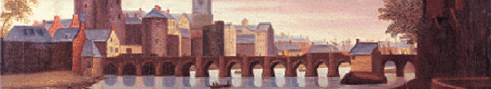
These photographs were taken on a walk along the Eglinton Canal in Galway. The walk was led by Michael J Hynes, and organised by Peadar Canavan, to whom I am grateful.
Updated February 2014 with some maps and additional information about Parkavera Lock, courtesy of Colin Becker.

Michael J Hynes

The biter bit (or snapper snapped): Peadar Canavan
The Eglinton Canal is a short canal, about three quarters of a mile long, that allowed a connection between Lough Corrib and Galway Bay. It followed a roughly semi-circular course around the west of the city (as it then was), bypassing the main line of the river and many other watercourses. It was built by the Commissioners of Public Works between 1848 and 1852; the original estimate allocated £27,000 for the canal and £11,000 to improve the flow to mills in the city. Other improvements were made to the Corrib at the same time and the Cong Canal, linking to Lough Mask, was worked on between 1848 and 1854 (but was abandoned before it was finished).
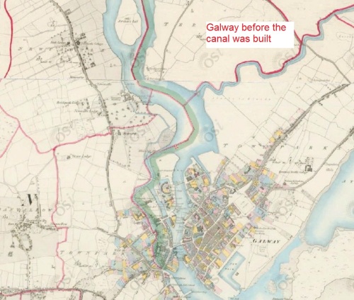
The Eglinton Canal is not on the 6″ OSI map …

… but it is on the 25″. Apart from the coloured extract from the 6″ OSI map above, all other extracts here are from the 25″ OSI map of around 1900, by kind permission of the Ordnance Survey of Ireland
Locks and bridges
The canal had only two locks: the Parkavera Lock (14′) about two thirds of the way along from the upper end, and the sea lock linking the Claddagh Basin to the bay. Maurice Semple, in By the Corribside, quotes the District Engineer as giving the length of the sea lock as 120′ but, in Reflections on Lough Corrib, says they were 130′ long. There were five hand-operated swing-bridges (swivel-bridges), made of wood on steel frames.
Colin Becker, in February 2014, wrote:
I can tell you that the useable length of the lock is a shade over 120ft ‘cos I went out and wielded my tape measure on it. The distance between the inside faces of the heel posts is 39.3m which is almost 130ft. What might be called the distance between the mitres. Thing is, there is a massive stone cill at the upper end; I estimate it to be about 2.5 metres wide, in effect reducing the length of the lock to 36.8m or about 120ft 6ins.
Ruth Delany gave the max vessel dimensions as 130’ x 20’6″ x 6’6″. The 20’6″ is right, the 130ft is optimistic and the 6’6″ is in fact pessimistic. I estimate the draft, at the upper cill anyway, as 2.4m or 7’10” but the draft limitation may relate to elsewhere in the system.
Maurice Semple says that the income from tolls was £370 in 1880, £35 in 1905, £10 in 1915 and £1 in 1916.
In 1954 Frank Bailey bought the Amo II, a 90′ motor yacht, from the Guinness trustees: it had been part of the family’s fleet at Ashford Castle. Bailey wanted to take it to the sea but, when the authorities examined the bridges, they found that, though they could be opened, they could not be closed again safely. Accordingly, even as Amo II passed down the Eglinton Canal, the swivelling bridges were being removed; they were replaced by fixed bridges that are still there today, and Amo II was the last large vessel to use the Eglinton Canal.
The first section, to the lock
The walk began at the Corrib Rowing and Yacht Club upstream of the end of the canal. Just upstream of the clubhouse are the remains of the viaduct that carried the Galway to Clifden Railway over the Corrib.

The remains of the viaduct

Jumping from the viaduct

The upper end of the canal
This is the club premises …

Corrib Rowing and Yacht Club. You can see this building on the Google satellite view
… where burglars are discouraged.

Deterrent
We walked through part of the university premises to the canal bank; this photo is at the first bridge, University Road (formerly Newcastle Road) bridge, looking back up towards the club.

Looking back upstream from University Road bridge
This is the same bridge; this shot shows the state of the water. Maurice Semple says that the original plan was for a canal eight feet deep, and forty feet wide at the bottom, throughout its length.

The state of the water. Note the railing at bottom right
I should point out, by the way, that there are lots of watercourses off to the right (east), including the Galway River (River Corrib) itself. However, they are not navigable, except perhaps by kayaks and yellow plastic ducks, so they need not detain us.
I think that the next photo shows the Convent River, which flows between two convents. On the back of Peadar O’Dowd’s book (see below), it’s marked as Nuns River. There were twenty-seven water-mills in Galway in the mid-nineteenth century; eight of them seem to have been powered by the Convent River, which itself was fed from the canal.

Convent River
We are walking along Upper Canal Road, or perhaps Canal Road Upper.

Canal Road Upper
The road curves along the canal …

The curve of Upper Canal Road
… and you can see a youthful angler about half way along.

The angler

University (Newcastle) Road Bridge to Presentation Road Bridge
We are between University Road Bridge and Presentation Bridge. I hope any visiting Galwegians will be able to correct me on the next bit. I think the first photo below is Presentation Road bridge, looking back up the canal, and that the second is the next one down, New Road bridge, again looking back upstream. The bank is now called Lower Canal Road.

Presentation Road bridge. You may just about be able to see something suspended from, or caught by, a wire or rope running across the canal beneath the bridge

New Road bridge
This photo shows clearly a railed-0ff area to the right of the bridge. My guess is that that was to accommodate the swinging mechanism and perhaps the swung bridge. British waterways expert Chris Deuchar says “The landings for the swing bridges are quite clearly seen.”
Parkavera lock

Newcastle Road Bridge to Lr Dominick Street Bridge
Below New Road bridge, we come to Parkavera lock (“Parkavera” is an anglicisation of the Irish phrase for “the mayor’s field”).

Above the lock. Presumably the footbridge is a recent (since 1954) addition
Maurice Semple tells us that, in the late nineteenth century, the big wall surrounded the Atlantic Sawmills, Cloherty & Semple, Proprietors. You can make out some of the words.

Cloherty & Semple, Proprietors. I presume they were getting a supply of water from the canal
Now for the lock itself.

The gate: keeping up the level
Note the shadows on the wall, bottom right, like something Nancy Blackett might have drawn. And, above the beam on the right, what may have been the ground-rack/ground-paddle gear. Chris Deuchar says
At the upstream end, I agree that there is substantial ground paddle gear and again, following the English pattern on some waterways, I would expect the lower gates to just have gate paddles.
Colin Becker writes:
I also concluded that the breast gates that are in situ (the deep gates are totally gone) could not actually operate because the footboards are fixed and would foul the sluice-gear if you tried to open them. Whether the gates themselves were replaced or just the footboards it’s hard to tell. The foot-board brackets are substantial iron castings and not hinged. The hinges would have to be in the boards themselves. And they are conspicuous by their absence.
The sluices are all ground racks with very substantial iron head-gear and they appear original so I don’t think they have moved.
The balance beams are rather short for the job but they could have been shortened in more recent times.
The rails and the ladder are presumably recent additions.
Here’s a closer look at the gate itself.

A closer look at the gates. No sign of any provision for gate-racks/gate-paddles
Here’s a lopsided shot along the lock chamber. The lower gates seem to have been removed completely. I presume that the two metal boxes at the rear of the left-hand gate recess were for the gate collar. I don’t know what the two recesses, with steel straps across them, were for. Nor do I know why there are two stone blocks protruding into the gate recesses on the far side.
Chris Deuchar commented:
… it is interesting to see how much remains — including, as you point out, the gate collar ground anchor which is very English in pattern. As for the two recesses below the gate, I am sure the metal plates are a recent addition simply to stop people at the railings from slipping down the holes. Originally I suspect one had a ladder and the other was for stop planks as the … photo [“The lock from below”] shows a similar pair on the opposite side.
There is often a problem in that paddle rods on the gates foul on the wall and so either there is a recess in the masonry or the gate timbers act as a buffer. In your case I think this may be what the stone blocks are for? If there were more I would also suggest they could be used as a ladder because they are obviously staggered.

Looking along the chamber
Here is a more distant view of the lock. The two streams are coming back in from the Convent River, having powered mills along the way (when there were mills, that is). The main part of the Convent River flows into the Galway River (River Corrib) a little way east, again having powered mills en route.

The lock from below

Scenic, eh?
Downstream to the sea

From Parkavera Lock to the sea lock
This house on the far bank adds to the attractiveness of the canal.

Canalside flowers
Next comes Dominick Street bridge. Interestingly, a map in Maurice Semple’s By the Corribside shows this bridge, but doesn’t mark it as a swivel bridge, whereas the others are so marked. The canal looks rather narrow along here, with little room to swing a cat — or a bridge.

Dominick Street bridge (looking back upstream)
Here’s a close-up of the stone building on the left of the previous photo. I have no idea whether it is of waterways significance, but I liked the look of it.

Stone house

Thalatta! Thalatta! Looking downstream
John Glynn tells me (see Comment below) that this bridge, the last one, was called Ballsbridge. It too was a swivel bridge, leading into the Canal Basin or Claddagh Basin [about which I have a page here]. To the east, it became the Claddagh Bridge over the river. The canal’s stream seems to turn to the left above the bridge and flow over a weir into the river.

The bridge above the basin

A better view of the bridge itself

The bridge from downstream, across the basin
The sea lock is in the opposite corner to the bridge. It too is disused, which seems a pity.

The sea lock from above

The sea lock from below
We end with some scenes from just outside the basin.

Boats at the Claddagh Quay

Outside the wall of the basin
In that last photo, you may just be able to see, to the right of the black boat on shore, what looks like some lock gear. Here’s the black boat again, but it’s no easier to see the gear.

Traditional boat Ga Gréine [Dart of Light] ashore

How’s that for a bowsprit?
I think I’ve already used this last photo on at least two other pages, but what the hell ….

Under way
Finding out more
If you can get hold of it, Peadar O’Dowd’s little book, published in 1985, provides an excellent explanation of the many waterways running through Galway.

Galway City Waterways
This site covers the many watercourses running through Galway city and the number of mills relying on them. And here is Corrib Connect, the site of the Lough Corrib Heritage Working Group.
The abandonment of the navigation required at least two statutory instruments here and here.
But the expert on the Corrib was Maurice Semple, who wrote many wonderful books —packed with photos, maps and extracts from documents — on the subject. Here are two of them; try abebooks for others.

By the Corribside

Reflections on Lough Corrib
Here is a page about the Ballycuirke Canal, west of Lough Corrib. Here is a page about the Cong Canal. And here is F E Prothero’s account of the Galway and Mayo lakes in the 1890s.
I learn (from William H A Williams Tourism, Landscape and the Irish Character: British travel writers in pre-Famine Ireland The University of Wisconsin Press, Madison 2008) that Thomas Colville Scott, lead assessor for the Law Life Assurance Company of London, wrote of the Eglinton Canal in 1853:
I am at a loss to know what the new traders on the Lough are going to carry, seeing that the surrounding country is all but hopelessly barren.
Scott’s report, edited by Tim Robinson, was published by Lilliput Press in 2005.
![]()
[wotw1]


My Mother, Eileen Curran of Vesey Lodge, Oranmore. Bought the “Ships Piano” from the Amo II at auction in Bailey’s Hotel, Eyre Square for £15.
My Father, Paddy Curran and I took it home on our donkey and cart and we must surely hold the record for the fastest time from Galway to Oranmore by ass and cart because each time the cart went over one of the many potholes on the way the piano jangled and the donkeys ears went further back and he put on another spurt until we reached the safety of our back yard.
The piano is a “J.B.Cramer Model No.1” and is in the attic of my home here in Dublin.
It is my intention to restore it to it’s former glory but as the years advance I am comming to realise that the road to God knows where is paved with good intentions.
That’s fascinating, Frank. Whatever you do, don’t throw it out: it might be the last remaining relic of the Amo!
bjg
Very interesting.
The last bridge was once Ballsbridge, apparently built by the same engineer, Balls, who built Ball’s Bridge (Ballsbridge) in Dublin.
Hardiman in his history (1820) marks it as Ballsbridge on one of his maps in his History of Galway
Thanks, John. I’ve amended the text accordingly. Did I get the other names right?
bjg
As far as I know you did, but I’m definitely no expert.
It’s a great record, very interesting.
Thanks.
Great page. My Dad always called the Convent River “The Western River”. I grew up beside the Eglington Canal north of the University Road bridge. The canal was our swimming pool during the summers. My brother used to go snorkelling and found old stone ginger beer bottles and other nineteenth century relics in the silt at the bottom of the canal. The lower lock gate at Parkaveara was removed in the late 1970s, I think.
Nice to have a pleasant memory amidst the gloom caused by the Shannon floods. Thanks, Barb. bjg
Frank
Very interesting about the piano bought at auction in Bailey’s Hotel.
Frank J Bailey (owner at the time) was my Grandfather and I would be curious to know if you know of any other items that were sold at auction, in particular ant Art/Pictures because there was an article in the Connaught Sentinel abt 1951 when my Grandfather supposedly purchased a Rubens at auction in Headford , but to date I cannot find any more information on this item.
Any information would be greatly appreciated.
Many thanks
John Bailey
Hi John. I was born on Canal Rd. As a child the names on the Canals varied but was mainly knowen as 1st 2nd and 3rd Canal. Sometime in the 60s the upper, lower thing started. Great job on site. It would be lovely to see the Canal open to the sea again. All the best MB.
That’s very interesting. And if anyone else has local knowledge like that, do please let us have it! bjg
Slightly unrelated, I know, but does anybody know what happened to the Eglinton, the large vessel used by Guinness (Lord Ardilaun) as a cruiser between Galway city and Cong during the second half of the 19th C ?
Many thanks.
According to Maurice Semple in Reflections on Lough Corrib, the “Lady Eglinton” was not owned but subsidised by the Guinness family. I think he has got the name wrong: the lake steamer was the “Eglinton” whereas the “Lady Eglinton”, owned by the City of Dublin Steam Packet Company, did two runs across the Atlantic, between Galway and the St Lawrence, in 1858. D B McNeill, in Irish Passenger Steamship Services Volume 2: South of Ireland, said that the (lake steamer) “Eglinton” “was owned originally by the Lough Corrib SN Co but in her latter days she was registered as the property of Lord Ardilaun.” She was built for the Corrib in 1862. Semple says she was sold in 1898, to be relocated to the Shannon, but McNeill does not list ehr amongst Shannon steamers. He says she was broken up in 1904 but doesn’t say where that was done. Ruth Delany’s The Shannon Navigation does not include the “Eglinton” amongst vessels that worked on the Shannon. And although new services did begin on the Shannon in 1898, Patrick Flanagan in Transport in Ireland 1880-1910 shows that all the steamers were newer than the “Eglinton”.
The short answer, therefore, is that I don’t know. If anyone can help, do please post a comment.
bjg
Great site, it brought back many memories of living beside the canal (Lower Canal Road) through the seventies and eighties. The railed off area to the right of the New Road Bridge photo is relatively new and didn’t exist during my time there. We regularly fished for trout in the canal but mainly caught perch and eels.
Mrs McHugh (from 14 Lower Canal Rd?) organised the cleaning and planting along the canal (with her troupe of underage helpers) which greatly enhanced the canal, but unfortunately I believe it’s reverted back to its wild state again.
Next time I’m in Galway I will retrace your steps with my kids and hopefully trigger some more memories.
Thanks.
Thanks, Eamonn. It’s a lovely walk and maybe Mrs McHugh will have a successor! bjg
To John Bailey,
John, I don’t have any information about the list at that auction but unfortunately I can assure you that we didn’t acquire a Rubens.
Frank.
Lovely site, thanks for the memories. As something a successor to the afore mentioned Mrs McHugh, I used be part of the local university kayak club, and would organise annual clean ups of the canal, as this was where we taught people how to paddle. We’d take everything out of the water, from numerous discarded fishing hooks and line, to traffic bollards, steel safes, and even a cast iron bath tub once, from underneath Beggar’s Bridge.
Of course, by the time next year would roll around, most if not all of the traffic cones would be replaced by students…
Thanks, John. Why were the students in the canal? Oh, wait …. bjg
A 160 year old boundary wall to the canal, located along Canal Road Lower has been knocked this year. Building work is ongoing (oct 2012). An integral part of the Eglingon Canal waterway has been lost forever.
Oh dear. Sorry to hear that. Incidentally, it is some years since I have been to Galway so I am always glad to have news of changes along the Eglinton and the Corrib (even if the changes themselves are unwelcome). bjg
I remember the UCG students having an annual “boat race” as part of rag week in the 70’s. It was 99.9% for fun, the vessels all being homemade and hydro-dynamically inefficient the race [over a suitably short distance] lasted long enough to provide huge entertainment [for the students anyway!]. I remember one winner with an unusually fast winning time who paddled a llarge old-fashioned metal [internally enamelled] bathtub to victory. Finally a boat worthy of the name? My memory is that the spectators were not delighted with the ease of his victory and were not sated until they managed to critically swamp the tub. The jubilant captain stayed with his ship to the end!
I suspect that this is the bath tub mentioned above.
Excellent. More recollections like that would be very welcome. bjg
Oh Boy! this brings me back almost 60 yrs. As a child I saw “Baileys’ Barge”on its voyage from Lough Corrib to the open sea. I remember it clearly to this day and for some reason we were all very sad. My Mother brought us( some of my Walsh cousins) up to the Canal informing us that we would be able to tell our grandchildren that “we saw the last Barge coming down the canal. I remember the lough on University Bridge being closed for the last time. I was so glad when a solid road was put over it. Who can remember the sound of the rickety planks that was the road. arump, arump, arump hurry before they break. The Auction, My Grandmother was there and bought a couple of things, Yes I know there whereabouts.
thank you for the memories. On another note,all that happened during our first recession. We didn’t know any better as children, we were protected.
Oiche Mhaith John
Agnes Henderson Murphy
Nearly forgot well done Peadar almost neighbours
Agnes
Hi. My wife and I have recently purchased and moved into a house on Lower Canal Rd and I am fascinated on learning anything and everything about our new neighbourhood. Even the street name is up for debate! It is known both as Lower Canal Rd and Canal Rd Lower. Also, our house has a name, Ensleigh and I am fascinated as to how that came about.
John- the -not -so- bad, I’m sure
Look up Micheál Breathnach,my cousin he submitted a piece about upper/lower canal thingy
AHM
The S.I. No 6/1963 LCN Act was to authorise the Lough Corrib Navigation Trustees to abandon the Claddagh Bridge and the Navigation thereunder on the Eglinton Canal at Galway. Does anyone know if the “navigation thereunder” included the Claddagh Basin? Or, do the Lough Corrib Navigation Trustees still have responsibility for the Basin? Thanks, joe
Good question. My impression is that the basin is kept in water as a side-effect of keeping the canal in water. I think that the Trustees maintain the canal as a scenic amenity, so it needs water, but not as a navigation. The basin may be full of water as a side-effect of keeping the canal in water but I noted, on a recent visit, that there is now only one pair of gates, so boats could enter or leave the basin only when the tide makes a level. The Trustees may therefore retain responsibilities for the basin but those responsibilities may not include keeping it navigable. However, that’s guesswork on my part; I’ve set some enquiries in train and will report back. bjg
Thanks bjg.
The reason I am asking is that we were prevented from sailing a 1905 Dutch barge into the basin a few years ago. Apparently the city engineer was instructed by the LCNT (Cllr Catherine Connolly) not to unlock and open the gates. We were under the impression that the basin and canal was built for boats, ships, etc.
Hmm. That tends to support my interpretation: if the trustees have no obligation to maintain the basin as a navigation, they’re not going to take on any possible liability by letting boats into it. The boats that were in it a few months ago, when I last visited, and the one tied in the lock chamber, may have entered without approval. I have no information on the matter, though. Were there two pairs of gates when you were there? bjg
Just one set of gates close to the footbridge. It would seem to me that the LCNT want the authority for the waterways but not the responsibility. I would love to know if in fact they have the authority and legal right to refuse entry to the basin. jg
[edited. bjg]
I’m still speculating, but I see no reason why they would not have authority to refuse access to their property. bjg
My original question was really asking is the basin LCNT property, or did they relinquish it with S.I. No 6/1963 LCN Act ? If the basin was included in their abandonment, then they don’t own the property. If that is the case, I wonder who does own it and which bye laws apply to it?
I still haven’t had a reply to my enquiries; I’ll pass it on when I get it. However, I see no reason to believe that the property was abandoned along with the right to navigate it and the corresponding responsibility to keep it navigable. bjg
Pingback: Mr Roberts and his basin | Irish waterways history
Frank Curran
John Bailey here Frank Bailey’s grandson.
Do you or anybody else know if “Cingalee 11” was part of The Guinness “fleet” as I have a photo of it at Inchagoill showing my Grandmother , my father John and Dorothy and Derby Farragher.
About 1925?
Regards
John
Pingback: Trials and tribulations when holidaying in the Emerald Isle – My Great British Adventure
Sorry John,
I can’t help with any information on “Cingalee 11”.
Frank Curran.
The “Stone House” at the Dominick Street bridge apparently was the Lock Keeper’s lodge according to Peadar O’Dowd’s booklet “Galway City Waterways.” Anyone familiar with Galway a few years back will remember it as a branch of Bank of Ireland.
Thanks for that. bjg
This brief article (from 2005) includes a photo from 1954, showing the Amo II, making the last voyage of a large boat through the canal.
https://www.kennys.ie/News/OldGalway/09062005-TheEglintonCanal/
Thank you for that. bjg
Unfortunately, the Parkavera lock gates are no more. The lock is now just a waterfall, with a modern footbridge installed above.
https://galwaymayoinstitute-my.sharepoint.com/personal/declan_maher_gmit_ie/_layouts/15/onedrive.aspx?id=%2Fpersonal%2Fdeclan_maher_gmit_ie%2FDocuments%2FAttachments%2FParkavera_Lock%5B1%5D%2Emp4&parent=%2Fpersonal%2Fdeclan_maher_gmit_ie%2FDocuments%2FAttachments&slrid=ecf3449e-b076-5000-be81-05fed5d01c07
There are fresh moves afoot to tackle the many issues associated with all of the Galway city waterways: http://www.inshore-ireland.com/News/galway-city-s-hidden-canal-system.html
That’s interesting; thanks, Declan. Unfortunately the GMIT address requires logging in and the ProActivate Ireland website, linked from the Inshore Ireland article, seems to have expired. However, I did find the Galway Waterways Association here [url]https://galwaywaterways.org[/url], though there’s not much on it. bjg
Sorry, Brian – it was just a short clip I took yesterday that shows the continued demise of the canal as a canal. It makes the images, description, and discussion of the lock in your blog to be even more pertinent. From being current, the information has suddenly become historically relevant!!! Anyway, hopefully, the clip is playable now: https://drive.google.com/file/d/12qXbh7lSblLHUJE6yDk7Bx1pAfit5ONO/view
Further general media relating to this particular Galway waterways renewal initiative are linked below and they include an email contact point for further information:
http://www.advertiser.ie/galway/article/92854/large-turnout-at-workshop-to-plan-future-of-galway-waterways
http://connachttribune.ie/neglected-waterways-filled-heritage-potential-455/
Great: thank you very much. bjg
Last Summer I saw kayakers going down the waterfall at Parkavera lock… it was guite a sight !
Gracious. bjg
Pingback: Day 46 – exploring in Galway and Dublin before heading to Rosslare - Steve's Travels
I was reading this interesting piece and as I scrolled down through it, there was my folkboat/yacht that I had kept at the lower lock gate for a while. It was a blast from the past. Unfortunately it was badly vandalised and sunk there. I had to get a 25 tonne crane to hoist it out, I took it home but never repaired it. I ended up giving her away for free to a man from Dublin. Better that he fix it up as he had more time on his hands.