
If you’ve come to this page after walking from Connolly Station to Newcomen Bridge and then to Cross Guns Bridge, as described on this page, welcome back.
In 1790 the Earl of Westmoreland, the Lord Lieutenant, laid the first stone of a lock at Phibsborough, at what is now Cross Guns Bridge. At the time, the lock and the bridge were named after the Earl, and the Ordnance Survey map of 1907/11 still shows his name (you can switch to the Historic 6″ map, from around 1840, and the Historic 25″, around 1900).
But even the OS map of 1837/44 shows the lock as the fifth, with four more (nos 4, 3, 2 and 1) between that point and the Royal Canal Docks, and another lock, a sea lock, between there and the Liffey. So why did the Earl start at 5 rather than 1?
The answer is that the terminus of the Royal Canal, as originally conceived, was not at the Liffey but at the Broadstone. Indeed, in evidence to the Railway Commissioners, whose Second Report was published in 1838, the Royal Canal Company Engineer, Mr Tarrant, said that the canal had two branches: one went to Longford while the other “branch from the Broadstone level is 2 miles, when it enters the River Liffey”. The line to the Liffey was clearly of less importance; the harbour at the Broadstone was close to the city markets and to many institutions including the Richmond Penitentiary, the Richmond Lunatic Asylum, the North Dublin Union Workhouse, the Female Penitentiary, the Linen Hall and the Queen’s Inns (it’s useful to look around the area on the older Ordnance Survey maps). There was a Royal Canal Hotel at the Broadstone and that was where the (passenger-carrying) passage-boats left from.

The Broadstone Harbour with King’s Inns in the background, early 1820s
As it happens, the Royal Canal Company quickly realised that there was more money to be made from grants for extending the canal to the Liffey, and on 10 April 1809 William Gregory, Secretary to the Directors General of Inland Navigation, certified that
The Extension of The Royal Canal to Coolnahay (six Miles beyond Mullingar) with the Harbour and Aqueduct near Dublin, and the Docks and Communication with the Tide Water in the Liffey are finished.
The phrase “Broadstone Branch” suggests that it was less important than the line from Royal Canal Docks (the Spencer Dock was a later addition, north of the Royal Canal Docks); that’s why I’ve used the phrase “Broadstone Line”. And, thanks to Dublin Corporation, most of the route has been preserved and can still be visited today.
This photo was taken from a car on Whitworth Road, looking (more or less) south. The red and grey building is Dakota Court, a block of flats, which is covering much of the old junction between the Broadstone Line and the Docks Line. Whitworth Road is separated from Dakota Court by the railway and the Royal Canal.
Incidentally, Whitworth Road runs alongside the Porterhouse North pub, north of Cross Guns Bridge, one of the very few Irish pubs that serves any good beer … although there is much to be said for a pint of Guinness in the Gravedigger Kavanagh’s.

Looking south across canal and railway at Dakota Court from Whitworth Road
Having driven a little to the west, turned south to cross Cross Guns Bridge and turned left (east) on to Royal Canal Bank, we can look further east along the front of Dakota Court. The Royal rises particularly steeply from sea level at the Liffey until Blanchardstown: apart from the sea lock (now being restored), there are twelve locks, eight of them doubles (staircase pairs in British canalspeak; in Ireland a double counts as one lock). There are three of them in the stretch from Cross Guns Bridge (behind us here) to Binns Bridge, less than half a mile away to the east. We’re looking at No 4 (you can see the black and white beams) while No 5, opened by the Earl of Westmoreland, is behind us, above Cross Guns Bridge.

Dakota Court flats conceal the junction’s east bank
The flats were built over the eastern edge of the junction with the Broadstone Line. That’s particularly regrettable because there was a dry dock on the bend.
There doesn’t seem to have been any provision for a bridge across the start of the Broadstone Line. Any horse-drawn boat travelling to or from the Docks at the Liffey would have had to either travel at least half way down the Broadstone Line or use the north bank as the towpath between Cross Guns and Binns bridges. If anyone knows how this problem was solved, please let me know.

Dakota Court down to 4th Lock
The western side of the junction is better defined and, as the name of the road is Royal Canal Bank, we can be assured that we’re in the right area. The grassy area was, I suspect, where the canal ran.

The west bank at the junction: Royal Canal Bank (looking south)
There are pay-and-display parking spaces down past the grassy area, so let’s drive down there and park the car. Looking back north from the parking area, we see a white building where the canal used to be. Note also that the road nowadays crosses the canal line here; just out of sight it turns sharp right and climbs to the North Circular Road.

The white building from the car-park
If we walk back north, past the white building, we get a better view of the line of the canal.

Looking north up the line of the canal from behind the white building
Mountjoy Prison is to the right: it’s where, according to Brendan Behan, the old triangle went jingle-jangle along the banks of the Royal Canal. There is a side entrance into the complex here; the photo below is taken from the lane leading towards that entrance, looking north …

Looking north from halfway up
… while the next one is from the same place, looking south, towards the white building again. I think that the dockyard was in to the left at this point, with two dry docks: these were in addition to the dry dock at the junction.

Looking south from halfway up
A quick peek into the prison. I think that the building on the right is a fairly new car park (it’s not on the Google Maps photo, which shows an open car park instead) and that it’s covering the dockyard.

Looking east from halfway up
There’s a mix of old and new houses on the west side of Royal Canal Bank …

Looking west from halfway up 1
… with several lanes leading up through them.

Looking west from halfway up 2
Return to the car-parking area and, facing south, take this lane up to the North Circular Road. Turn around and look back north, to where we’ve just come from.

Looking north up the lane 1
And to the west, we can look along the North Circular Road towards Doyle’s Corner (if it’s still called that).

Looking west to Doyles Corner
What we’re standing on is (or was) Blacquiere Bridge (Sir John Blacquiere was a director of the Royal Canal Company). Google Books will find Ireland Illustrated: from original drawings by George Newenham Wright, 1831, and you can see a drawing, from this bridge, of two turf-boats moving on the Broadstone Line. This is a second shot looking north up the lane, with a corner of the Phibsborough Library on the right.

Looking north up the lane 2
Here is the Library itself: an elegant building, beautifully fitted out inside with wooden shelves and a wooden area for the staff just inside the door. It was very busy when I visited it, but the staff were nonetheless helpful to a stranger. Shortly after it opened in 1936, it was issuing an average of 900 volumes daily, with up to 1500 on Saturdays. We can deduce, I think, that this section of the canal was filled in before 1936, and Ruth Delany in Ireland’s Royal Canal 1789–1992 The Lilliput Press Dublin 1992 says it was infilled in 1927.

Looking north at the Library in the Canal

Library opening hours
This building is to the east of the bridge: note that the Royal Canal Bank, having crossed the canal, emerges beside this building.

The north-east corner of the bridge

Royal Canal Bank nameplate
Here’s a photo taken from outside the library looking south towards Blacquiere Bridge. Had the canal not been infilled, this shot would have shown the water under the bridge (but then the photographer would have got wet).

Looking south from the Library
The next shot is taken from the (north side of the) bridge itself, looking south. The big wall on the right was the State Cinema.
In September 1933 the Lord Mayor of Dublin, Alderman Alfie Byrne TD, opened “Dublin’s new play centre”, a “boon for city children”, a “tasteful park that had now been laid out by the Corporation on what was some six years ago a canal waterway.” It included an enclosed area for children up to the age of fourteen, where they could play in safety. The Carnegie UK Trust had contributed £500 and the keys were presented to Mr Charles E Jacob, Hon Treasurer of the Civics Institute. The making of the park had provided work during a period of high unemployment — and the scheme preserved the line of the canal.

Looking south from the bridge
You can’t drive in from the North Circular Road, but you can walk down the steps by the side of the cinema. There is access for vehicles from further south.

The wall of the cinema dominates the steps
The linear park runs along the left side of Royal Canal Bank.

Royal Canal Bank south of the bridge
Here’s a shot looking back up north to the bridge.

Looking north to the bridge
The whole thing is beautifully kept: a credit to Alfie Byrne and his successors.

Looking south along the linear park
Geraldine Street comes in from the east, dividing the park.

Looking east to Geraldine Street from the Royal Canal Bank

Looking back north along the linear park from Geraldine Street

Looking south along the linear park from Geraldine Street
To the east is the entrance to one of Dublin’s little-known gems, the Blessington Street Basin, completed in 1814, which supplied the north side of Dublin with water drawn from the Royal Canal. It also supplied Bow Street Distillery (originally owned by Haigs and later by Jamesons) until well into the twentieth century. I gather that its tranquillity may have been threatened at one stage ….

The entrance to the Blessington Street Basin
If you spot this remarkable house, you’re opposite the entrance to the basin.

House opposite the basin
The photos of the basin need no commentary.

The Blessington Street Basin 1

The Blessington Street Basin 2

Looking north along the western edge of the basin

Looking towards the south bank of the basin

Looking south-east across the basin

The north-west corner

The north-east corner

The island
Back on the line of the canal, we notice it curves around to the right. The canal crossed Constitution Hill from east to west on the Foster Aqueduct, to reach the Broadstone Harbour.

Approaching the southern end of the Royal Canal Bank

The line curves towards the (former) aqueduct and the Broadstone
In 1845, the Midland Great Western Railway Company (MGWR) bought the Royal Canal. Doing so allowed it to run its lines beside the canal, which it did most of the way to Mullingar, without having to conduct lengthy negotiations about wayleaves with individual landowners. The company built a terminus at the Broadstone, with a pontoon bridge (which was moved out of the way when boats entered or left the harbour) to provide passengers with access to the station.
_resize")
The Broadstone, from The Tourist’s Illustrated Hand-Book for Ireland 3rd ed David Bryce, London 1854
In the drawing above, a boat is approaching the pontoon bridge (the structure with railings on either side of it). Regular contributor Pat Conneely has kindly supplied a very early photo, showing the station and the canal; this photo must have been taken before 1877.
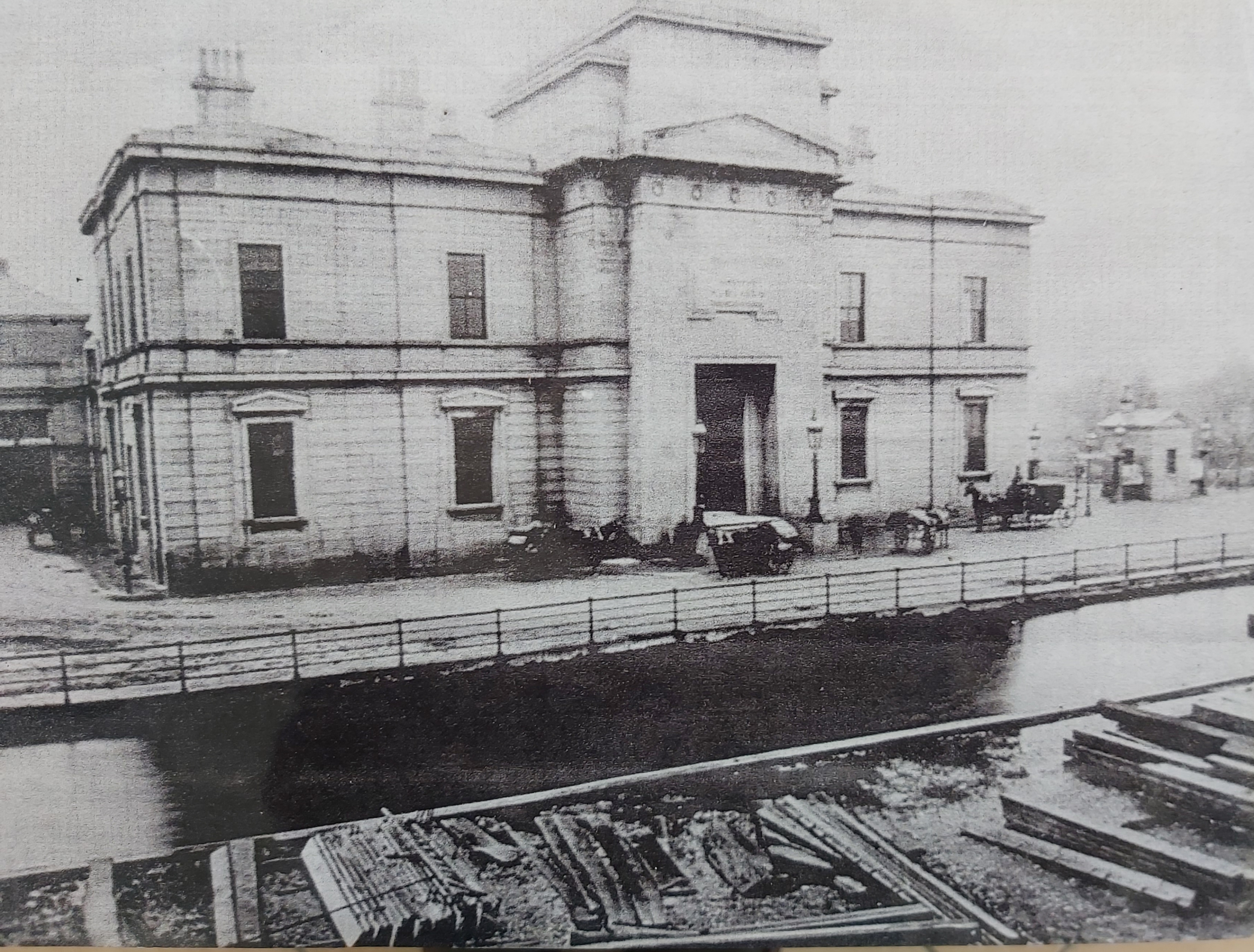
The Broadstone station before the canal harbour was filled in (photo courtesy Pat Conneely)
In 1877, the company did away with that nuisance by filling in the harbour and adapting the Foster Aqueduct to provide access to the station from a new road, later called Western Way. The canal traders were provided with a turning circle and a wharf on the east side of the former aqueduct and they no longer used the Broadstone.

Triangular patch (part of turning circle?) north of Western Way
The Foster Aqueduct itself was removed in 1951 to allow road-widening, but you can stand on Western Way and try to imagine what it looked like.

Landmark building on the far side of Western Way

Landmark for pedestrian exit to Western Way
Alternatively, you can go to Constitition Hill and visit the Broadstone itself.

Broadstone Avenue off exit to Constitution Hill
I wouldn’t want to suggest that anyone should travel a little further south, turn right and just drive in to the open car park in front of the Broadstone: after all, someone probably owns it. You could walk up this ramp-plus-steps instead.

Pedestrian access to the Broadstone from Phibsborough
At the top, there is a stone edge (the further line of stone in this photo). Could it possibly be a remnant of the line of the canal leading in to the harbour? It’s difficult to be certain from the old maps, but it looks as if the canal widened out somewhat after it had crossed the aqueduct. It then headed south-west before turning south and broadening into the expanse of the harbour, which stretched almost as far south as the Queen’s Inns. There is a copy of an 1818 painting of the harbour on the National Library’s website (HT Michael Slevin).

Possible edge of canal harbour 1

Possible edge of canal harbour 2
There is a statue where I think the aqueduct came in.

The statue on the aqueduct
This next photo is taken from near the statue, looking across to Western Way. The line of the canal is in behind the nearer set of buildings.

Looking from the Broadstone across the absent aqueduct
Turning back inside the harbour area, this photo looks more or less to the south, probably down the harbour. The MGWR terminus building is behind the photographer.

Looking down the harbour
The Broadstone terminus was just one — admittedly the most imposing — of several railway buildings that took over the site. In a way, its splendour proclaimed the victory of the railway over the canal. But its glory was not to last. In September 1929, it was announced that, following the purchase of the Irish Omnibus Company by the Great Southern Railway, the Broadstone terminus was to become a bus garage, with most trains being transferred to Amiens Street. Eventually the trains left altogether.

MGWR HQ 1

MGWR HQ 2

MGWR HQ 3

A car-free photo taken in October 2011
Back down to street level for another few photographs. This is I think the western abutment of the aqueduct (or part of it).

Street-level view of western abutment (from south)

Street-level view of the statue

Stone beneath the pebbledash
And this is looking across the widened road to where the canal was.

Street-level view of the far side of the aqueduct

The Foster Aqueduct (courtesy Pat Conneely)
Then back up the ramp-and-steps …

The ramp and steps back up
… for a final look at the Broadstone. I know it was responsible for killing a canal, but surely the MGWR building deserves better than this: locked away, practically invisible, and with its immediate surroundings detracting from its appearance. Perhaps these people have the right idea.

Farewell to the Broadstone
My January 2010 review of Ruth Delany’s and Ian Bath’s updated book on the Royal Canal is on the Irish Times website.
There is an account of the Broadstone’s history on the Irish History Podcasts site. You can download a PDF description of recent archaeological excavations, with results relevant to an understanding of the harbour, here.
If you are following the suggested walking route around the Dublin canals, go to this page, which will take you from the abandoned line of the Royal Canal to the abandoned line of the Grand Canal, with some comments on pubs, swimming and Guinness barges along the way.
Another Royal Canal walk, from Dunsink to Broombridge, is described — with a free downloadable podcast — on this site.
If you are down wid da kidz in da technological hood, and know what QR Codes and NFC Tags are, and have one of those newfangled telephone devices, be aware that you get get more information as you visit some places along the Royal Canal; and if you’re still, like me, trying to get to grips with the non-existence of telephones with dials, you can print information in advance from Canals of Dublin, which explains all about the scheme.


Hello,
Its strange to read about the Broadstone Extension, my myself & my brother Frank have just returned from Ireland where we have been walking the Royal Canal ( and doing a bit of fishing along the way ), as kids this was our play ground. We used to play in the dry dock before it was filled in to build the Dakota Printing works. I remember standing at the cross Guns Bridge with my Dad watching the last barge go down the canal i think it must have been 1953. Its so good to see that they have re-generated so much of it, they need to declare it a national park. We were never aware until your article that the canal went to Broadstones as it was filled in before we were born. The drainage for the drydock passed back into the canal below the next set of locks via a stream which we called the ‘ Micky Murry’ it was a was a test of courage to be able to jump over the stream.
That’s really interesting; thanks for posting your comment! I hadn’t realised about the outlet from the dry dock, but now you mention it I can see that the Ordnance Survey map of 1907 shows something looking like a stream between the towpath and the wall of the prison. Would that be it? And have you any idea why it was called Micky Murry? Was the dock kept full (of water) or empty when you knew it?
The Ordnance Survey map also shows a crane on the bank outside the dry dock. I suppose that was gone when you were playing there?
If you have any more information or memories, do please post them here!
bjg
Replying to myself to pass on some more information from Andy Clarke. He says:
“Just a bit more info from older brother Frank. The dry dock was empty from 1955, and the crane was used to move limestone blocks that were stored along the side of the dock prior to being moved to the dressing yard which was beside the library. I remember watching the big cutting saw in action. Frank tells me the the name Micky Murry was the local kids’ name for the drainage stream.”
Has anyone else got memories of the dry dock or other aspects of the Broadstone line?
Was there also a railway running from Whitworth Road to Broadstone? If so, was that along the bank of the canal spur?
John
Thanks for your questions. The Broadstone was a railway terminus after the Royal Canal was bought by the MGWR; it became the steam depot for Dublin in 1937, before it became a bus garage and Bus Éireann’s HQ.
However, the MGWR had to keep the canal going, so canal and railway were in operation at the same time. The railway line approached the Broadstone from about north-north-west. You can still see where it passes under the North Circular Road and the New Cabra Road, and if you use Google Maps, select the satellite view and ask it to find Broadstone Dublin, you can follow the line of the tracks. This link MAY work ….
Thanks for your article, I visited Phibsborough recently and walked past the site of the aqueduct, I wondered why the ground was raised on both sides of the main road so this makes sense now.
Can you tell me what the name was of the mill building next to Cross Guns bridge in the Victorian era?
i enjoyed this trip along royal canal it brought back beautiful memories we played and fed the ducks in the basin as children late 40s are there any photos of the aquaduct from constitution hill i would like to see them
Thanks for your comment. I haven’t seen any photos of the aqueduct myself. If you’re in the area, I’d suggest dropping in to the Phibsboro Library: they have a small local history collection. There is a well-known drawing of the aqueduct (search google images for “foster aqueduct” + “dublin”). bjg
If I’m interpreting Bernard Neary (A History of Cabra and Phibsborough) correctly, the mill was originally Robert Mallet’s Ironworks (known as Mallet’s Folly; Peter Clarke in The Royal Canal calls him John Mallett) up to 1860, when the Murtagh Brothers took over and set up the Dublin North City Milling Company. Ranks took over in 1957. bjg
Thanks for the information, I’ve seen a reference to it being called ‘Shandon Mill’ but this may be a more recent title. I wonder why it was nicknamed Mallet’s Folly? John was a distant relative of mine hence the interest. He owned another foundry in Ryders Row (near Parnell street) which supplied the railings surrounding Trinity College on Nassau Street.
Shandon [Park] Mill was the next mill up, closer to the sixth than to the fifth lock; Shandon Gardens is above the sixth.
Googling for “Mallet’s Folly” (one T) gives several results, and I see that there was a Robert as well as a John. Neary gives no explanation for the name, unless we can deduce that it was awarded as a result of Mr Mallet’s giving his employees “a special day’s feast” and free beer to mark Queen Victoria’s coronation. bjg
That’s helpful to know.
Robert was his son and they co-owned the business. If you Google ‘Robert Mallet’ you’ll find a lot of info about him, he was a well respected engineer and scientist known as the founding father of Seismology. John became the High Sheriff of Dublin in the 1830’s.
‘Dublin: the city within the Grand and Royal Canals’ by Christine Casey has several references to J & R Mallet, two are relevant to this thread:
M & GWR Broadstone station http://tinyurl.com/broadstone
which mentions the canal and aqueduct and the foundry at Cross Guns Bridge
http://tinyurl.com/crossguns
My great grandfather William King Lived inPhibsboro and opened a Family Grocery and Italian Warehouse at 162/163/164 Phibsburo road on June 4th 1880.His son William M King built the Phibsboro Picture House in 1911.I would like to get more information about the above
I’m afraid I can’t help you there: I don’t know much about anything other than waterways. I presume you’ve looked at the online 1911 census http://www.census.nationalarchives.ie/. I imagine the 1900 (or so) OS map would be interesting, but it’s no longer available on http://www.osi.ie. Would it be available in your local library? bjg
Thanks, Richard: I’ll have to get that book. bjg
There is a picture of the foster acqueduct from 1950s in “Lost Dublin” by Frederick O’Dwyer.
Hi,
very well done on your first class article on the broadstone Branch.Over the years the R.C.A.G organise walks from Binns Bridge to the 12th Lock. I outline the history of the Canal and also the local history alonh the line.(all wellcome,no charge). We will be walking again soon with Phibsfest and again all wellcome.
Thank you for reference to my book,it it is common for people to use the information and not credit the author.
You are correct when you saythat the existing 5th was the 1st lock when work started in1789.However at that time the line was to extend to Bolton St. to connect with the road going north.The Broadstone came later.I detail why in the book or my TCD thesis on the Canal.
Again very well done,
regards
Peter Clarke
Thanks, Philip. I have that book, but hadn’t thought to look at it. The structure is a massive one, all the larger because, O’Dwyer says, an iron cap was placed on top to carry a road. The photo seems to be from the collection of Maurice Craig and I presume it’s still in copyright, so I can’t put a copy here, but the book is well worth getting.
bjg
Peter: thanks very much for your comment. It’s nice to get a commendation from a real expert. I note what you say about Bolton St; thanks.
This page is one of the most popular on my site, so people are interested in the Royal. I’d highly recommend Peter’s guided walks: the Royal in Dublin is stunningly attractive, with massive locks, wonderful stonework and lots of historic sites along the banks. The new is good too: the aqueduct crossing the M50 is a wonder to behold.
Here’s a link to the Phizzfest (9-12 September 2010) and here’s one to the Royal Canal Amenity Group.
bjg
“Mallet’s Folly” was so called as although the mill was intended to be powered by water from the canal the rights were never granted.
However the mill was put to good use producing spikes and bolts for the railways.
I enjoyed your information on the Royal canal, as I grew up beside it in the 40/50 It was our playground. What you refer to as the Micky Murry we called the Lake why I dont know but we did jump it and sometimes into it. I also remember getting into the dry dock before Dakota bought it. Our parents didn’t allow us up the canal but we went anyway. I also remembr allowments on the banks by the prison. I rember the State being built before that it was called the Phiser. We wandered all the way to Broadstone along the park there was a playground at the end near the Broadstone. Memories.
Eleanor: nice to hear from you. Do you remember any trading boats on the canal? I think Leech of Killucan ceased trading in the early 1950s, and he was the last to go.
bjg
I would have to recommend an article from the IWAI’s IWN that was commisioned by the then editor in 2001. It may be found at
Click to access beatentrack.PDF
Well I would, wouldn’t I :)
And rightly so. Good point and good article. bjg
I really enjoyed this article. I went to the site following a recent discussion on when the Broadstone branch was filled in.I grew up in Primrose Avenue in the 1940-50s and our play area was the Basin, Broadstone Station, the canal park and the canal behind the Library where we used swim and raft in the dry docks. My memory was that the stream around the ‘Joy’ was called Mickey Dudleys Stream. I learned to swim where that stream entered the canal opposite about midway on Whitworth Road. The Aqueduct and carpark outside Broadstone Station was surfaced with smooth tar, so we were all expert roller skaters! Our two favourite adventures were:
1. Crossing the bridge on the OUTSIDE of the railings overlooking the traffic, which thankfully was much slower than now; and 2. Watching for cattle trucks with trailers coming up the hill past Temple Cottages and then going down the hill on our trolleys UNDER the oncoming trucks. Sometimes they would have just been washed out and the angle of the trucks would give us a very ‘aromatic’ shower! We used to get the trolley wheels in the CIE dump behind All Saints Church on Phibsboro Road. One summers day on the way back from the dump, there was a wedding in progress, so we decided to watch from the greenhouse while partaking of the vicar’s grapes. We were enjoying it so much that we failed to notice the Vicar sneaking up behind us. We were marched into the presbytery and after duly giving false names and addresses we were let off with a stern lecture on the 7th Commandment ”Thou shalt not steal”!
By a curious coincidence, I later worked in Dakota Printing and even later I was involved in the production of Bernard Neary’s ”Dublin 7”. The final photograph in that book is one I took from my bedroom window looking across the Basin towards St. Joseph’s Church, Berkeley Road. I have a photograph of Foster’s Aqueduct which I will forward to you. There was a band stand in the centre of the park at the upper Basin gate. You new there was a band there not only by the music but also by the clouds of dust blowing across the top of Primrose Avenue. It was a very close community and I can recall almost all they families who lived in the 38 houses. Tahnks again.
How can I email a jpeg of Foster’s Aqueduct to you?
Thanks very much, Pat: great to have information from people who actually knew the place (I’m a southsider myself). bjg
I’ve emailed you direct about this. bjg
I was born and spent many happy childhood years in one of the four late Victorian houses ( St Catherine’s Terrace ) pictured here on Royal Canal Banks opposite the gate to the Blessington Basin. The children who lived on the Royal Canal Banks and the surrounding streets (Geraldine, Primrose, Myrtle, Auburn and Shamrock on the east side, and Phisboro Road, Kelly’s Lane, Bradstone Avenue and on the west side old canal park used the playground at the southern end of the Park.
There were bandstand shows opposite our house on certain Sunday afternoons in high summer. An evening celidhe dancing show with pipers and kilted dancers was presented on alternate Wednesdays. The bandstand was built from the orignal canal stone, and they used to lay it up with dancing boards. We got our local groceries from Moore’s or the Auburn Dairy, and the big shopping from Liptons of Phibsboro crossroads on Saturdays. Old Missus Clitheroe sold whole fresh fish and sometimes shellfish from a pushcart on Fridays. Tel -el- Kebir Daries delivered the milk and DBC the bread and cake.
My best friend was David Falls from Myrtle Street. Our immediate next door neighbour’s boys were a little older myself but were kind enough to indulge me with a ride on their ass and cart. These enterprising brother’s had a few pigs in a yard somewhere local and had a contract to collect the slops from local restaurants. I learned lots from these ‘big’ fellas, including a few words that were not popular at home when I tried them out on the folks. Miss Little, the elocution teacher was not impressed either, and sent for my parents. Needless to say it led to my first and not last serious spanking…….
My favourite treat shops were The Black Cat for lollies and the shop made Italian Ice Cream at the Phibsboro’ Cafe on the Phisboro Road, and Savios Fish and Chipper on Berkeley Road. You got a slight headache if you ate youe ice cream too fast, so you licked all the raspberry syrup off it first until the Ice cream started to drip. The local Catholic church was St. Joseph’s, where I enjoyed the long fancy dresses the priests wore, the polyphonic choir, and the incense.
I always wanted to know the name of the soldier in the I.R.A monument beside the State Theatre.
David Falls actually lived in Primrose Avenue in a house facing down Auburn Street. I clearly remember this as he had a very attractive older sister, Olive! Ena Hoey, who owned the Auburn Dairy and also a sweet shop in Wellington Street, lived next door. Her brother, Jim, was Best Man at my parents wedding. I will send on a picture taken in the Basin where we used to play ‘Cowboys & Indians’. Olive is one of the girls; also a picture taken in the Basin by my father on Whit Monday 1944 in which there are 30 children, all named. I’m in the front with the six-shooter!
The statue is dedicated to the local Irish Volunteers (Google IsabellaJ photos). Joe must remember a near neighbour of his, Mr. Mangan, who had a great collection of musical instruments and attempted to teach us to play. Sadly I never took advantage of this.
Since my last comment I have wondered about the hooks in the pillars at the top of Geraldine Street. They look like they were giant hinges for gates. The canal would have been 8 or 10 feet below this level. They are a mystery! Further up the canal we had several swimming places. At the ‘Pin Mill’ and at the ‘Bends’ where the canal crossed the railway line from Heuston (then Kingsbridge) Station which ran under the Phoenix Park and through Glasnevin Cemetery and on down by Whitworth Road. Between the Bends and Broombridge there were old train carriages on a shunt line which we called the ‘Ghost Train’ and there was also a small farm. Still further up there was a great swimming place beyond Ashtown opposite a big house, Cherry Hall, owned by the Walton family of music fame. You didn’t have to be able to swim as one dive would take you across. You had to be quick to get out on the far side and dive back in as the bank was patrolled by very unfriendly Kerry Blues who seemed to like the taste of young swimmers! I saw one boy being caught and it wasn’t pretty!. In the summer, for those of us without bathrooms this was the ideal spot for the weekly outdoor bath, complete with soap!
Hi my name is Freddie Hamilton my grandfather William and my father Freddie ran a shop and a wholesale business at 215 Phibsboro road which I think closed in the late 50s. Would anyone remember this I would really appreciate if there was someone who could recall this as I am still running the wholesale business.
freddiehamilton@eircom.net
Where was 215, in relation to Doyles Corner or Kellys Lane?
Hi Pat thank you for answering me 215 was south of doyles corner just past all saints anglican church on way to the Boadstone but on opposite side of the road. Alas it is gone now replaced by new townhouses. The shop and the wholesale business were all run from 215 and from the late 20s until the mid 50s they kept horses in a stable up a lane to the side of the shop which were used before they aquired delivery vans.My grandfather William came from manchester sometime between 1911 and 1918 when my father Freddie was born.I was not born until 1957 my grandfather had died in 1954 as I said I am still running the business from Kilcoole Co. Wicklow and would love to know does anybody remember the shop.
Looking at the Google Map it seemed to be to the left of Kellys Lane (it has Kellys Lane and Phibsboro Place transposed!) I can’t recall a shop there. What kind of a shop was it? My friend Francis Byrne lived in Kellys Lane, in a very old low cottage just beside the pole in the centre of the lane. Off Kellys Lane there was a lane that ran parallel to Phibsboro Road. There were stables and pig sties and at the end there was a farmyard with two milking cows where I remember buying a can of milk during a milk strike sometime in early 1950s.
Great memories, Joe; many thanks. bjg
That’s very interesting, Pat. I’ve always believed that more people swam in the canals in Dublin than ever boated on them, and it’s a neglected aspect of Dublin (and waterways) history. I have written an (unpublished) article on the subject, but you’ve just added more information! bjg
I don’t know the area myself but you might find it useful to ask in the Dublin City section on boards.ie. bjg
Hi again Pat yes thats the stables on Kellys lane parallel to phibsboro rd. The stables were at the back of the shop. It was I am sure a sweet shop since thats the business we are in. There was an earlier reference in this article to a sweet shop called the black cat I wonder was that it. I am pretty sure it was then turned into a bike shop after my father left. Maybe your friend Francis might recall.
My older sister recalls the shop, on the left at the corner of Kellys Lane, facing on to Phibsboro Road. She said there were 2 or 3 steps and boxes of vegetables used be displayed on either sides of the steps. Despite enquiries, I haven’t been able to find any more information
Hi Pat once again thank you for your efforts, yes this indeed was my grandfathers shop in other enquiries I have made some people remember the steps going up into the shop that sold grocery, veg, sweets etc and they think our name hamiltons was the name over the door. Like you my eldest sister remembers going for the milk at the end of kellys lane for her nanny hamilton. From the sound of things then hard but happy times.
Pat as a youngfella on the van with my father I remember delivering sweets to shops on mountjoy street back in the sixties. There was Miss Morrisons shop which was on the corner, she ran the the shop with her brother Amby. I think there was a school up the lane beside the shop. We also done a shop opposite morrisons which I think was called Healys would this area be part of the broadstone area. I also remember a shop up opposite the church with a huge boot on the roof.
Does anyone remember the old State cinema being called the Blacquiere picturehouse. I remember my father, who used to drive a horse and cart into the markets, from north co Dublin in the 40’s/50’s talking about the Blacquiere bridge ,picture house & school.
The Blacquire picture house was built in 1913 by William King.He ran it until the late 1930s.
I have some pictures and details on the history of the picture house which I must give to the local Library.
Brian W King
Thanks for that information, Brian. let me know when the library receives them.I would like to see them.
Sean McDonnell
The cinema that was demolished to make way for the State was called the Phibsboro Cinema, known locally as the ‘Phizzer’. It was originally called the Blacquire (before my time!), presumably after the adjacent Blacquire bridge on the North Circular Road which crossed the canal where the library is today. The canal continued on down where the park now is and eventually to the Broadstone Harbour.
The screen in the ‘Phizzer’ was about 7 or 8 feet from the ground and the front seats were only about 4 feet from the screen, or wall! Any child caught misbehaving was sent up to these seats and would have a seriously strained neck at the end of the film. The last film I can remember seeing there was ‘The Count of Monte Cristo’. We always considered the nearby Bohemian to be a superior cinema. When the State was built it was ‘state-of-the-art’ for the time. A novel and welcome innovation, as we left childhood behind, were the double seats in the back row of the balcony… sin sceal eile!
I wonder if Brian King is the same one as was involved with the Print Museum?
Here’s a few more bits of interest.
p424 in The Dublin Penny Journal shows an illustration of the Broadstone Aqueduct, Phibsborough:
http://books.google.ie/books?id=9gLSAAAAMAAJ&pg=PP13&dq=phibsborough&lr=&as_drrb_is=q&as_minm_is=0&as_miny_is=&as_maxm_is=0&as_maxy_is=&as_brr=1&as_pt=ALLTYPES&redir_esc=y#v=onepage&q=phibsborough&f=false
or use:
http://tinyurl.com/7rqmcly
LUAS BROOMBRIDGE
Advance Archaeological Testing
at Broadstone
Assessment Report:
Click to access BXD_EIS_Book_5_Annex_M1.pdf
or use:
http://tinyurl.com/7mdruf2
Also further info on Mallets on the Irish Architectural Archive:
http://www.dia.ie/architects/view/3346
After Millets moved on, Dublin North City Milling Co. Ltd., The North City Mills moved in.
Info on one of their Managing Director, Patrick Egan, here:
http://en.wikipedia.org/wiki/Patrick_Egan_%28land_reformer_and_diplomat%29
According to Industrial Heritage Ireland:
‘Located in Phibsborough, this former mill is located beside the Royal Canal and was also served by its own railway siding from Liffey Junction.
Water was supplied from the Royal Canal to power the mill. As the Lock above the mills is at a higher level, it was possible to take water from here and pipe it through the mill, returning it to the canal below the lock.’
ref: http://www.industrialheritageireland.info/TikiWiki/tiki-index.php?page=North+City+Mills
only buildings not mentioned 4 cottages on 6th level as i live in one of them we are trying to create history of them thanks Vinny
Like many of your commentators,the general area was our playground also,as we lived on St Attracta Rd in Cabra, attended St Peters School and St Vincents Primary and secondary School.The Phibsborough CBS were called the Panama Troop as this was the name of the building they occupied. This building was located behind the library and It was a corrugated half circular structure.My admittadly vague reccollection is that the site was originally a dry doc for boat repairs, which fell out of use due to decline in demand,and this turn of events led to the scouts becoming the occupants, thus fulfilling the old wisdom-one man`s meat is another man`s poison,I suppose it`s fair to say. In it`s stead now stands a proper concrete structure,with secure parking and my guess is that the Dept of Justice are the new owners. My brother Terry and myself were members of St Peters Church choir,conductor Peter Summerville and the Christmas treat was all members were invited, free of charge, to the Bohemian Cinema,from which two films in particular stand out. One was “Lassie” A story of a remarkable return journey, with bleeding paws,having travelled over a hundred miles, once she escaped from the wretched thieves who had taken her from the elderly gentle owner,pining for her return.We had our own Wicklow Collie at this time,and every heartwrenching scene in the film found it`s mark in us.You know I think I saw a tear in Terry`s eye,but thought it better not to mention this. The other was Mario Lanza in “The Great Caruso” wonderful memories from wonderful times. Alfie Byrne was going to arrange for us to be allowed get off school in the summer if it turned out to be a sunny day.Was I the only guy in the entire School who believed him, in fairness he did say, so far the minister had not agreed to the proposal, but he was optimistic:The 40`s and 50`s –Cabra/Phibsboro- It was a great time and place to be there. Brian Lynch.
We used to swim in the dry doc and we had a raft there also. Dangerous if you couldn’t swim as it was about 20 ft deep.I later worked in Dakota on the same site. Also many happy memories of the ‘Boh’ and Bulldog keeping us in order. Alfie Byrne’s other great political promise was ‘to put shoes on the footless’! It was indeed a great time and place to have grown up.
In relation to a previous contributor, Freddie Hamilton (18/1/12), I saw a van with the name ‘Freddie Hamilton Wholesale’ on the M3 recently and wondered was it the same person?
Hi Pat and other broadstone and phibsboro contributors,yes indeed pat that was one of my vans which is the wholesale business my grandfather william started from his shop at 215 Phibsborough road in or about 1928 delivering from a horse and car which were kept in kellys lane at the back of the shop and he was there working with my father until the mid fifties when my dad who was also freddie moved to bray, they also supplied coal etc in the early days. I am looking to see if i can get a photo of that side of the road back then as can only seem to see the opposite side where the all saints church is.
Do you remember the long low cottage at the ‘crossroads’ in Kelly’s Lane, where the pole was in the centre? My friend Francis Byrne lived there in the late 1940s and early 50s. The cottage at that time was about 150 yrs old.
Hi Pat no I was not born until 1957 and am only going on stories about kellys lane and the shop from my father who died in 1975 and my grandfather died in 1954 so i am craving for any information or old photos i can get about that area of Phibsboro road.
Came across the site whilst browsing and thought it may be of interset to comment on the Spencer Dock lifting bridge to the canal. We lived on the North Wall quite close to the Dock in the late 30s and my late brother and I very often watched the Bridge being lifted; mainly for an old coaler, the Saint Mungo, to enter and unload its cargo of coal in the adjacent coal yard. The Bridge Master was a delightful old type character who was always smartly dressed and always wore a bowler hat. He took great pleasure in timing his own measured passage under the bridge as it was lowering to emerge at a very steady pace with the bridge about one foot over his head. I suppose the canal was navigable at the time as I remember a british motor boat, it must have been just before the war, tied up outside on the Liffey bank, waiting for the appropriate level of tide to be reached for entry.
That’s very interesting[ thanks, Peter. I see that there were two Saint Mungos, both owned by Heitons; the first was sunk in the first world war while the second (pic here) was built in 1920 and scrapped in 1953, which fits the dates you give. The Bridge Master is someone I didn’t know about and I’d welcome more information if anyone has it. The Royal Canal was not officially closed until 1966 but the last trader, Leech of Killucan, ceased operating in 1951; I have an article about Leech here. bjg
Pingback: Vanished Dublin: Royal Canal Harbour | Sibling of Daedalus
Pingback: Canal carrying 1846: the Royal Canal | Irish waterways history
Does anyone remember a Margaret Mahon who lived at 67 royal canal bank she would have been 28 in 1961 and worked as a printer
My sister in law Maura (nee Gouldsberry) brought this site to my attention and I have read back over the correspondence with great interest and a lot of nostalgia. My name is mentioned several times by my former schoolmate and friend Pat Conneely, and I thank him for mentioning so fondly. Let me say that I left Dublin in 1969 and have lived in different parts of Ireland ever since. I note from the correspondence above that some are keen for information on Phibsboro Road and the people who lived say, in the area around Hamilton’s shop. So, here goes:-
Let’s start at Royal Canal Bank end of Kelly’s Lane and walk up the slope towards Phibsboro Road. (Remember now that this is 1950 or thereabouts). On your right you have Maguires’ garden wall and the four Allen Cottages occupied by the Smiths, The Heveys, my Aunt Teasey and in number 1, Tom Cassidy. On you left is the Kennedys’ back gate. At the pole you have the cottage mentioned in previous entries (where my family resided). We are now at the ‘crossroads’. On the left, Mr Holden with his daughters Kate and Chris. Next door the Myles family. On your right, the Brennans. Off to the right was Phibsboro Place, a couple of cottages and Hanlon’s Yard, a piggery. Back to the crossroads and on your left was another lane the left side of which contained the back entrances of Royal Canal Bank dwellings. Small houses on the right hand side (McEvoy, Murray, Greene, Howard, Delaney,Brennan, Hickey, Then Jackie Sheridan’s stable with, finally Tommy Foley’s stables and milking parlour behind double red gates proclaiming “Melrose Dairy, prop T. R. Foley”.
If you’re still with me let’s go back to the “crossroads” and carry on to Phibsboro Road passing the gate of Wades’ backyard, (stable,fuel shed,hens). Turning left at the corner you have Wade’s shop, then Miss Doogue’s sweetshop (The Black Cat). Next is a house occupied by the Norton Family and then a building let out in flats to two or three families. Costello’s dairy and grocery with its yard occupies a corner site behind which is a small enclave containing a couple of cottages one of which houses the McLoughlins.
Coming to the end of this episode I hope Freddie Hamilton is still awake and reading. Across the dividing lane from Costello’s there are two shops
which during my time were knocked into one the better to accommodate a growing wholesale sweet business established by Mr and Mrs Hamilton and operated by their sons, known to us kids as Freddie and Ollie. A friend of mine, Denis Maguire, worked for them as a van boy.
If there is any interest in further particular information about the area I will be glad to supply what I can.
Again. Best regards Pat. I hope you are well.
Francis
That’s great information, Francis; thank you very much. I hope Pat will see it and respond …. bjg
Francis Byrne you have just made my Christmas thank you very much that is a fantastic insight into Phibsborough road and the Hamiltons wholesale sweet business which is still going today run by me and my 2 sons Freddie Jnr and Barry. I am the son of Freddie that you mentioned and Oliver was my Uncle who emigrated to Canada with his family in the late 50s or early 60s I never met him or my grandfather William or Grandmother Sarah who started the business or I haven’t even got a photograph of either of my grandparents or the shop on phibsboro road where it all started. My father moved to Bray around the time I was born and ran the business from there.
Thank you so much and a very happy Christmas.
Great to hear from you Francis. As I said in an earlier contribution I couldn’t remember any of those shops on Phibsboro Road, but I do remember the farmyard at the end of the lane and getting milk there during a milk strike. Was there a Tommy Myles lived in Kelly’s Lane? I seem to remember he had a nickname, Snuksie! Francis and I were also altar boys together in the Mater Hospital – under the watchful eagle-eyed Sister Damien. One of our fellow altar boys and schoolmates Eddie Griffin is Parish Priest in Loughlinstown, Co. Dublin. I am always encouraging older people to put their memories on paper and as a consequence of my earlier contributions, I decided to just that. My father was a prolific photo taker and wrote place, name and date on every picture so along with his photos and my own and my sisters’ recollections I put together a memoir and called it Childhood Round the Basin. I published it on the occasion of my sister Una’s 80th Birthday Party in the Gresham Hotel in May 2012. Sadly she passed away last August. The book has been seen by various cousins and nieces and nephews around the world . . . And to think it all started over an argument about the Royal Canal! Thanks to this website. A Happy Christmas and a Prosperous and Peaceful 2015 to all.
PS. My mother had a great friend called Annie Gouldsberry. I wonder are they related?
Thanks for your contributions to the discussion, Patrick, and a happy Christmas to everybody from around the Broadstone and Phibsborough. You are absolutely right about the importance of people getting their memories down, whether on paper or on the internet, so that important information is recorded. If your book is on sale, I’ll be happy to provide a link to wherever people can get it. bjg
Published just for the extended family and friends. Thanks all the same
I have information that the small building on the north east corner of Blaquiere Bridge was once a schoolhouse. It went by the name of Phibsboro Sunday & Day Schools (or Blaquiere Bridge Schools).
It was built in 1826 and in its centenary year of 1926 an appeal was made to past pupils and friends for donations to a £400 extension and repair fund. At that time its teachers were Mr. A. Keegan and Miss H. M. Gill.
The Board of Governors included the Rev. H. G. Forde, St. George’s Rectory, Iona Crescent, and A. B. Beck of St. Peter’s Road, Phibsboro. The Hon. Sec. was Mr. James P. Kermode of 3, St. John’s Terrace, Clontarf.
I don’t know when the school eventually closed but it was still running in 1933.
By the early 1970s it became a unit of St. Michael’s House (Mentally Handicapped Assoc.) and my wife was head there for several years. During that time I lent a helping hand in converting the basement into a playroom but not before salvaging some old papers giving the above information. I left Ireland in 1975 so do know how long St. Michael’s continued to use the building.
I was of course completely unaware of the fact that a canal used to run alongside the building. Furthermore I have to confess of never being quite certain of the exact location of Blaquiere Bridge – and there I was, practically standing on it!
My thanks therefore to the author of this article not only for its interest but for enlightening me after so many years.
I wonder if there an old print anywhere which shows Blaquiere Bridge as viewed from the north. With the schoolhouse being so old it may well have been included.
Just as a footnote, amongst the papers found was a small receipt from the Dublin Metropolitan Police – for a fine of 7/6 incurred on 20th Dec 1905 by Miss M. E. Henyell (presumably a teacher) of Phibsboro Schools for “footway not been cleansed”.
Cleansed of what I wonder (snow perhaps?). Anyway it must surely have ruined poor Miss Henyell’s Christmas!
Thank you very much, Jim, for that most interesting information. We have several Phibsboro readers, and perhaps someone knows of an old illustration of the bridge from the other side and of the school.
A fine of 7/6 was quite hefty for the time!
bjg
Hi there I really love all the photos and info on this area…I don’t know it all but I would love to find out more.my great grandmother Margaret Richardson lived at 1 Library View Terrace….I found her on the 1939 electoral register. ..I cant see it on google maps so I wonder if it’s been demolished?
Thanks, Kara. From a paper road atlas of Dublin, I think the address was probably Library View Villas, not Terrace. This link will take you to Number 1 on the Ordnance Survey Map; if you switch to the Historic 25″ map, done in around 1900, you’ll see the villas hadn’t been built at that time. On the Google map, search for Phibsborough Library, zoom in as far as possible and you’ll see Library View Villas shown to the left of the library. As far as I can make out, in my photo “Looking north up the lane 2“, you can see the garden railing and shrubbery of Number 1 sticking out on the left, but I’m open to correction on that as I’m not able to go and check it. bjg
Hi All, Like many of you I came across this site by accident. I was born in 1948 and lived in the “Borough” until 1950. My mother was from Castle Terrace. I came back to Phibsborough in 1957 and went to St. Peter’s BNS.
I would like to give you some information about the scouts. Originally there were 2 dry docks adjoining the Broadstone Branch beside Mountjoy. The scouts both the site around 1932 and erected a Nissan Hut. One of the dry docks was filled in and used as our “lawn.” The other one was still open up to 1974.
The prison services bought the site off the scouts and built the 2 storey car-park which is still to be seen.
The scout hall was known as “Panama” and the replacement hall which is close to the “white” building shown earlier is still known as Panama. The story goes that when the original scout den was being built Joe Donnelly, who lived in 52 Connaught St., was in the play “Arsenic and Old Lace.” One of his lines was “I’m off to Panama” meaning the Panama Canal. The den got the name Panama from that time. I do remember Kelly’s Lane and the pole in the middle. There was a guy who lived beside it, can’t remember his first name, but his surname was Brady. He used to go around on a bike renting out hardback books. This was in the late 50s.
Keep the stories going folks and thanks for all the memories. TCO
Does anyone remember Gerard and Mary Mahon and their daughters Margaret and Annie and possibly a brother called William lived at 67 royal Canal Bank between approx 1956 to – 1963 possibly later
Hi All, I enjoyed seeing the wonderful
photos and reading about the area. I
came across this as I’m looking for any information about Kelly’s Lane in 1901,
especially old photos of the houses/cottages in the Lane, as my greatgrandparents lived there in 1901, their
name was Tiernan and my great grandfather Thomas Tiernan was a train driver. I’d appreciate any little piece of information. Thanks. Rita Shields
Fantastic work by the author. I run this route every day and really enjoyed learning more about it. Thank you.
You’re welcome. Thank you. bjg
Well, like many of those who have contributed to this story I also came upon it by chance. I was actually browsing the internet to find the words of O’Donovan Rossa’s Farewell to Dublin and which I had found courtesy of Colm O’Lochlainn but continued browsing anyway. I am not sure where the connection is but anyway… My most recent escapade was to join a friend on the train to Maynooth at Broombridge (he had boarded at Connolly with his bicycle) with my bicycle. From Maynooth we cycled back along the towpath of the Royal Canal and we parted company again at Cross Guns Bridge. For anyone who is interested it is a very pleasant journey for the most part, the only difficult part being the section between Clonsilla and Coolmine where the canal is a good bit below the towpath and the path itself is quite narrow and strewn with the roots of trees. Otherwise the path is good to very good.
With regard to the canal and Broadstone, firstly I should say that my great great grandfather was the solicitor for the MGWR and had an office in the Broadstone Station. In 2009 The Irish Times celebrated 150 years and in doing so made its archives free to air on the internet. At the same time I was recuperating from an illness and I availed of the opportunity to browse their archives at some length. It was both interesting and amusing to read reports of incidents that occurred during his time. He died in 1875.
I was born in 1946 and we lived then on Goldsmith Street just around the corner from Geraldine Street and backing on to the wall separating the houses from the old canal spur. I only remember it as a park and we left there when I was 5 years old. But I remember that we would climb over the back wall into a tree and climb down into the park. The thought of it now makes my hair stand on end! We had a maid in those days who would take us out for walks down to the Basin. My father also grew up on Goldsmith Street and he would play cricket on Geraldine Street at the entrance to the park which someone has referred to above. He said that they painted stumps on the stonework.
There has been some discussion about the scouts den up behind the library at the Blacquiere Bridge (pronounced Blackwire incidentally). I remember that my father on one occasion gave me a sixpenny piece to go to a jamboree up in the dry dock which was stepped as far as I recall.
I suppose my abiding memory of that time was the fact that ration books were still in operation and were used for instance to buy bread which we bought from Fusco’s Bakery at Doyle’s Corner. What keeps it in my memory was that the crusts were always burned and not very nice for a young child of my tender years. But we had to eat every bit of it nevertheless!
My mother was from Enniskerry Road at Cross Guns so we frequently went walking up along the canal as far as Liffey Junction and I still don’t know why it got that name.
I made my First Communion in St Peter’s Church from the Misses Dolans’ kindergarten on St Peter’s Road. Life was much less hectic then but as far as I recall we were always accompanied there and back. If my memory serves me too there were no traffic lights at Doyles Corner at that time. One of our contemporaries there was Paddy Liddy, the noted writer, artist and Dublin guide.
There was a reference also to the shop with the big boot over it opposite Berkeley Road church which I recall but I can’t remember the significance of it. However next door was Albert Power’s stonework premises. Albert was a famous sculptor up to his death in 1945. He made the death mask of Michael Collins and the statue of Pádraig Ó Conaire which used to grace Eyre Square in Galway. My father used to go fishing with him and he fashioned a leaping trout from my father’s fishing line which is now in the collection of The National Gallery. Finally among his other works is the coat of arms of the four provinces which hangs over the entrance to The Gresham Hotel. The interesting thing is that the Red Hand of Ulster is the wrong hand!
My father worked in the Civil Service in O’Connell Street and at that time also it was normal to work on Saturday morning before the five day working week was introduced. On one occasion together with my two brothers, one a little older and the other a little younger than me, we decided on a Saturday morning that we would walk in to town to meet him when he finished work. This was without telling anyone what we intended. We were 4,5 and 6. I think the whole department came out to see us as we trooped in to his office! Imagine doing that today!
Austin Clarke wrote about this area also in his book Twice round the Black Church. He mentions the custom at the time of visiting 9 churches on Holy Thursday. My grandmother would also take us children on that pilgrimage, starting with Berkeley Road and then the Mater Hospital and Dominican Convent in Eccles Street. The excursion would extend down by the Broadstone to Church Street and the old houses below Broadstone where the apartments or flats are now all had half doors.
There has been some mention of Kelly’s Lane. This of course became infamous for the the Kelly’s Lane Gang called the Invincibles who perpetrated the murders of Cavendish and Burke in the Phoenix Park in 1881.
On Phibsboro Road also about halfway between Broadstone and McGowans Pub there used to be some class of transformer station that was built on the roadway. During the War of Independence a curfew was in place. One night one of my uncles and a (Protestant!) friend were out playing cards after curfew and were heading home when they were spotted by Black and Tans from the bridge over the canal to the Station. They hid behind the transformer but were apprehended nevertheless and were put in to Mountjoy for the night for their trouble!
I hope that these few memories will be of interest to other readers. I hope also that with the development of the new DIT campus at Grangegorman and the LUAS to Broadstone and Broombridge this area will become a bustling place once again.
Very interesting; thanks, Dalgan. I don’t suppose you have any of your great great grandfather’s files: he might have been involved in mortgaging the Royal Canal to a [retired] lady of ill-repute.
On Liffey Junction, see the 25″ Ordnance Survey map here. As Industrial Heritage Ireland points out, the main line ran to the MGWR terminus at Broadstone; the line to the River Liffey, opened in 1864, diverged from the main at Liffey Junction. bjg
Great to see the continuing interest in this area of the Royal Canal.
Dalgan, you may have seen some of my earlier contributions which eventually led me to put them together in book form which I called Childhood Around The Basin. You obviously have a store of memories which I would urge you to do the same. With modern technology it is so easy and relatively inexpensive to self publish. It is a great legacy for your family.
Rita Shlelds. Read earlier contribution from Francis Byrne.
Thanks for the information about
Kelly’s Lane, Dalgan. My relatives
lived there for a short time in 1901,
a fair bit of time after the infamous gangs, thank goodness! All
goodliving, hardworking people.
There probably aren’t any photos
of the houses as they were then,
more’s the pity. RS
Hi, sorry I can’t find the comment by Francis Byrne. I did find a mention of Kelly’s Lane, is it that comment? Thanks for notifying me. RS
Sent from my iPhone
>
Rita: there have been so many comments on this topic that, on some devices, not all comments can be seen on the same page. Francis Byrne commented on 20 December 2014. bjg
Rita, this is Francis Byrne’s comment
Francis Byrne | Saturday 20 December 2014 at 22:59 |
My sister in law Maura (nee Gouldsberry) brought this site to my attention and I have read back over the correspondence with great interest and a lot of nostalgia. My name is mentioned several times by my former schoolmate and friend Pat Conneely, and I thank him for mentioning so fondly. Let me say that I left Dublin in 1969 and have lived in different parts of Ireland ever since. I note from the correspondence above that some are keen for information on Phibsboro Road and the people who lived say, in the area around Hamilton’s shop. So, here goes:-
Let’s start at Royal Canal Bank end of Kelly’s Lane and walk up the slope towards Phibsboro Road. (Remember now that this is 1950 or thereabouts). On your right you have Maguires’ garden wall and the four Allen Cottages occupied by the Smiths, The Heveys, my Aunt Teasey and in number 1, Tom Cassidy. On you left is the Kennedys’ back gate. At the pole you have the cottage mentioned in previous entries (where my family resided). We are now at the ‘crossroads’. On the left, Mr Holden with his daughters Kate and Chris. Next door the Myles family. On your right, the Brennans. Off to the right was Phibsboro Place, a couple of cottages and Hanlon’s Yard, a piggery. Back to the crossroads and on your left was another lane the left side of which contained the back entrances of Royal Canal Bank dwellings. Small houses on the right hand side (McEvoy, Murray, Greene, Howard, Delaney,Brennan, Hickey, Then Jackie Sheridan’s stable with, finally Tommy Foley’s stables and milking parlour behind double red gates proclaiming “Melrose Dairy, prop T. R. Foley”.
If you’re still with me let’s go back to the “crossroads” and carry on to Phibsboro Road passing the gate of Wades’ backyard, (stable,fuel shed,hens). Turning left at the corner you have Wade’s shop, then Miss Doogue’s sweetshop (The Black Cat). Next is a house occupied by the Norton Family and then a building let out in flats to two or three families. Costello’s dairy and grocery with its yard occupies a corner site behind which is a small enclave containing a couple of cottages one of which houses the McLoughlins.
Coming to the end of this episode I hope Freddie Hamilton is still awake and reading. Across the dividing lane from Costello’s there are two shops
which during my time were knocked into one the better to accommodate a growing wholesale sweet business established by Mr and Mrs Hamilton and operated by their sons, known to us kids as Freddie and Ollie. A friend of mine, Denis Maguire, worked for them as a van boy.
If there is any interest in further particular information about the area I will be glad to supply what I can.
Again. Best regards Pat. I hope you are well.
Francis
Are they going to reinstate the bridge to bring the Luas into the new DIT campus?
Thank you so much Pat for forwarding this to me, very much appreciated! Rita
Sent from my iPhone
>
Thanks for forwarding this to me bjg,
I very much appreciate it.
Rita
This site has full information and detailed PDF maps can be downloaded from this page. bjg
Pingback: Broadstone Luas works | Irish waterways history
Pingback: Blessington Street basin | Irish waterways history
Hi, I have really enjoyed this thread, your memories really bring this beautiful place to life! I was just wondering if any of you could forward old photos taken within the area of the park or Basin? I’m working on an Architectural project and I need to demonstrate a cultural understanding of this wonderful space.
Thanks
Dee Doyle
Note that I cannot publish photos here unless I am sure that I do so with the consent of the owner of the copyright, which is often hard to trace for old photos. bjg
I have some Basin photos, recent and old. I will send them to your email
I have posted a photo of Fosters Aqueduct on Glasnevin Heritage on Facebook
Thanks Pat, Photos of the area from the perspective of a local person are a valuable part of my research.
Thank you.
Dee
Any memeries of broadstone playground in the fifties and sixties girls on one side boys on the other ,rounders tennis boys football and hand ball
Wonderful to read this article and all the informative comments, especially Jim’s from 3/3/15. I bought the schoolhouse at Blaquiere Bridge in late 2013, undertook a big renovation before moving in back in January ’14. A lot of people still think it’s a school or crèche (Scoil Nasiunta is still written above its doors), but it’s now a private home. I spent a lot of time trying to find an old picture of it, having ascertained its history as a CoI school dating back to 1825/6. Remarkably, even after locating dozens of files in the National Library about the school and its pupils and teachers, as well as some other history through the Rathmines CoI Library, I couldn’t find a single historical photo of it or Blaquiere Bridge. If anyone has this, please message me.
Hi Jonathan, if you contact Don Doyle’s page on Facebook he may be able to help you
with an old photo of the school. My great grandparents lived in Kelly’s Lane and my
great grandfather, Thomas Tiernan, was an engine driver on the railway, possibly Broadstone? There’s also a possibility that their children may have attended school in
the house you now live in. Did you by any
chance come across an attendance ledger?
Best of luck on your house, lovely and
unusual house to live in. Rita
Hi Jonathan, I’ve also had a good search (online only) for an early picture of the school but wihout success. I suppose you have seen the engraving,1836 I think, showing Dublin from Blacquiere Bridge. The school would have been directly behind the artist. It’s nice to think that the pupils in those days had merely to step out of the front door, cross the road, and take in this view. No doubt a few of them would have would have got up to some mischief as the barges passed beneath.
You did a wonderful job of renovation by the way. I’ve seen the interior shots on Myhome and can’t quite believe the transformation. It is difficult to relate them to the original layout. The conversion of the basement into a playroom in the 1970s included floor tiling, ceiling boards, etc., also a mural (I wonder if that was still there when you bought the place).
The old invoices and other bits of paper which were found there have been donated to Dublin Library – they said they were going to send copies to Phibsboro Library.
Thanks, Rita and Jim, for the replies.
Jim, I’ve seen the engraving from 1836 and suspected that the view was from the NCR looking towards the city – it’s a pity the canal was culverted back in the 1920s, though it’s nice that the library was built in such a nice location, a little oasis from the mayhem of Phibsboro village! I never saw the mural in the basement you mentioned in your reply. The previous owner did a lot of the basement works before I bought it, so the new ceilings, stud walls etc. were done before I got the place. I did retain what were perhaps the original doors for the toilet in the front of the house beside the entrance hall. They are Gothic/ ecclesiastical style and very unusual.
Rita, I found dozens of attendance ledgers all in the archives section of the National Library on Kildare St. They had boxes and boxes of dusty old files on the school, mostly dating back to the late 1800s and early 1900s (I only looked through about three of them though) with some fascinating documents – everything from invoices for maintenance and repairs, letters from parents to the school masters, reports of students’ deaths, assessments of student performance, assessments of teachers performance (not all glowing!), reports of incidents involving cattle running rampage in the schoolhouse and breaking windows (presumably from the days of the NCR cattlemarket), plans for extending the school… all in beautiful old spidery handwriting.
Thanks Jonathan, it’s good to know all
those letters and papers are preserved for
posterity. I agree with you about the hand
writing, beautiful penmanship.
Hi my name is Marie Belardo nee Marie g. Whelan grew up on Phibsboro Ave.1952 emigrated to the USA 1972 any information would be appreciated.
where would I look for old photos of phibsboro road
Albert Power also sculpted the statue of Our Lady overlooking the Broadstone junction where Foster’s Aqueduct originally carried the canal over Phibsboro Road into Broadstone Harbour (now the car park).
Great to hear the history of aphibsboro and Broadstone I grew up on Royal Canal Terrace Danced in Charlevile And Panama great times ,would love to hear from anyone who played in playground also ,I am still in touch with friends who i grew up with in Broadstone and Phibsboro so lucky
Hi, I’m sorry I didn’t discover this site before my mother died. She was a Ring and lived in Broadstone. I spent alot of time in that house as a child. Does anyone remember the shop opposite McGowan’s? I can’t remember the name of the lady who ran it. She lived and worked there. The park, the Basin all hidden gems. A great part of Dublin. Louise
Hi, great site. Just wondering if anyone remembers Ellen (ellie) wade and
Bernard Wade from kellys lane, thanks
I remember a Tommy Wade who was a friend of Fran Byrne who lived in the cottage in Kellys Lane.
To Louise Marks. Was your mother Peggy?
Thanks Pat, It was myself Ellen and my brother Bernard ( Benny ) we left phibsborough when I was about 15yrs old around 58yrs ago. We lived their
with my mother margaret and father Joseph ( joe ) and granny Wade. My father grew up there. Don’t know if anyone’s old enough to remember. I have great memories from then.
Very interesting and well written article about the Broadstone canal line. I was a cub in the Phibsborough cubs/scouts in the late 1960’s and early 1970’s. The dry dock outside our scout hall was always fascinating to me, I was young and innocent and always assumed it was a swimming pool! I was always happy that the ‘pool’ was never filled as I was afraid that I might be asked to swim in it, it looked too deep. Here’s a photo of one of our cub/scout meetings at the Panama Hall alongside the dry dock. https://scontent-dub4-1.xx.fbcdn.net/v/t31.0-8/11845175_10207696797440250_2679792469331815498_o.jpg?_nc_cat=100&_nc_eui2=AeGlVfb14Wy0TXBZC4dARIPXHFxgg4vRQO9GqLz7K3KVXoCgQWz8re8dzewY2BEnSGMcgbRLYUBPPLSGjkz8zOoaF0YcGiAxFou2rRjT4HMBBw&_nc_ht=scontent-dub4-1.xx&oh=fb819591b427cfd5c195ea38c902997e&oe=5CA98719
Thank you very much for that. It’s the first photo of the dry dock that I’ve seen and I’ve put a link to it on the home page of my site https://wp.me/ppxzo-3Y2. bjg
Pingback: Royal Canal dry dock | Irish waterways history
You’re welcome, I love the history of the canals in Ireland. I’ve also cycled both the Royal and Grand canals from Dublin to their final locks at the Shannon, beautiful journeys.
Pingback: Egintons of Phibsborough | Moxhams of Ireland
My parents lived at 27 Royal Canal, Phisboro in 1942 and this is the address on my brothers birth certificates. Where exactly was this house and what street was it on. I would to locate it
I wonder if they meant Royal Canal Bank? If so, you cen see it on the Geohive map, and Nos 26 and 28 are marked. I can’t give a direct link to the location, but if you go to http://map.geohive.ie/mapviewer.html and search for Royal Canal Bank, you’ll find it. You may also be able to see the house on the Google maps. bjg
Many thanks for reply, as I said the address on both birth cents is 27 Royal Canal, Phibsboro. Is there any difference of location with the spelling Phibsboro and Phibsborough. I see on a map just below Royal Canal Terrace the name Royal Canal House. Are there other houses with just Royal Canal as address.
I was also wondering was the house on Royal Canal Bank and as you said there is a house 27 Royal Canal Bank, in fact there is a photo of it on the web, it has a blue door. The big question for me is, is this the house which is on the birth cents?
The two spellings Phibsboro and Phibsborough seem to be used interchangeably, as for other places like Lanesboro[ugh]. I’m not local to the area and I couldn’t say whether there are other places with just Royal Canal as the address; we have some occasional commentators who know a lot about the area and maybe one of them will be able to chip in here. Royal Canal House was the headquarters of the Royal Canal Company until it was bought by the Midland Great Western Railway in 1845. bjg
To Martin O’Reilly. If it is 27 Royal Canal Bank then it is opposite the top of Primrose Avenue where the poles are. Coincidentally my parents Joe and May Conneely lived next door in the white-painted house for a year after they were married in 1931. The house was owned by the O’Connor family. On the other side of 27 lived Mr Mangan, a music teacher and gaeilgoir, who I mentioned in an earlier contribution to this thread. My older sister Una was born there in 1932. They then moved to Primrose Avenue where the rented before eventually buying. Hope this is helpful
Pat: great to hear from the expert as usual! Can you think of anywhere else, other than the Bank, that the address might refer to? bjg
I have a new picture of the timber yard at Broadstone Harbour if you send me your email
Pingback: Broadstone addition | Irish waterways history
Hello. I’m a Kiwi just signed up for the Waterways Blog. Dalgan Kirwan’s post commencing with mention of his gt gt grandfather interested me very much because the latter might well have been acquainted with my 3x gt grandfather Patrick Farrell who had business premises as a ‘Smith’ at 25 Constitution Hill from the 1830s until at least 1847 when I believe he moved to Cumberland St South, probably because activity around the harbour was in decline. I believe he was at the top end and one old Ordnance Survey map shows a “Farrell Lane”. I further believe that the family originated in Longford and that he had brothers who also had businesses associated with the Royal Canal, including John, who was at No. 26 with a livery stable and Richard who had premises near the bridge in Robertstown, Kildare. I would like to see the Irish Times archive that you refer to Dalgan. Is there a link I can use please?
Farrell is a Longford name and the Royal Canal, and later the Midland Great Western Railway (MGWR), was an obvious route to prosperity for active folk like your relatives. The Irish Times archive is now open only to subscribers, which would make it expensive for you; try the British Newspaper Archive instead https://www.britishnewspaperarchive.co.uk/account/subscribe, which covers all British and Irish archives and might be better value.
Robertstown is on the Grand Canal, rival to the Royal, although the latter did lease the former for ten years in the 1850s.
bjg
A brilliant story. I’ve walked all of that area over many years but particularly this years. I often walk to city centre via Finglas Rd, down towards Dakota Apartments, to see the pair of swans there. Then up behind the Library and down the linear park to the Basin, where there are currently 6 cygnets & one parent. On a few occasions I’ve gone straight on.
Thank you. It’s a lovely area and the basin is a gem. bjg
As I’ve posted in previous comments, I had the privilege of growing up in Primrose Avenue with our house backing onto the Basin. We knew all the swans by their first names! 🦢🦢😄 It was then and still is indeed a gem!
I need to find out where Cabra Place was located. It no longer exists. Has it now been incorporated into Phibsborough Road? There’s a terrace of eight houses built slightly back from the main Phibsborough road near old Broadstone Station, opposite Royal Canal Terrace. Could the present renumbered 239 Phibsborough Road once have been 2 Cabra Place?
Paula Hayes
Shandon Mills and the North City Mills constantly get confused. Shandon Mill is the stone building adjacent to the 6th lock on the Royal Canal. The North City Mills (formerly Ranks) is adjacent to Cross Guns and was rail connected up to the 1970s, the railway into the North City Mills crossed The Royal Canal adjacent to the 6th lock, the bridge abutments can be seen today. Shandon Mills was never rail connected, it was a totally separate mill, the North Mills is now apartments but the gigantic grain silos still stand, abandoned and derelict.
I have been away from the site for a number of years and while reading tonight saw Aidan Herdman’s contribution in Nov 2018. I would be very interested in seeing the photo he mentioned, but cannot access it. I would appreciate it if any of our readers can point me towards seeing it at this stage.
Best regards,
tco
Came upon this site whilst googling for information about my grandfather David Falls Sr of Primrose Avenue and was surprised to see my mother Olive and uncle David Jr mentioned by Pat. Unfortunately Olive passed in late 2004 but David is still with us. After service in the Royal Navy he joined the Metropolitan Police. He is now retired and living in West London.
⁰I have a picture of Olive which I could send you.
HI,
I have three small points which might be of interest
I brought my elderly mum down to the Basin a few days ago. She remembers the old cinema before the State was built. It was known locally as the Blackwire and this ties in with the name of the bridge ‘Blacquiere’.
Also, as a child I was a member of the 19th Dublin scouts whose hall was located just outside the prison wall. I distinctly remember a dry dock outside the in the grounds of the hall. This was in the late seventies. It has been built on since. Incidentally, the scout troop are still known as the Panama troop. A clear humourous reference to the canal.
The State cinema replaced the Phibsboro cinema which in turn had replaced the Blackmore cinema. For those of us who were fortunate enough to grow up in that area its lovely to occasionly revisit the Basin or to bring grandchildren and feed the ducks.
Hi There, I read your blog and just want to give you some information. When the hall was being built one of the leaders was in the play “Arsenic and Old Lace”, his lines included “I’m off to Panama” meaning the Panama Canal. That is how we got the name. I was in Panama from 1957 -1970, and have been involved again for the last 8 yrs and am currently an Adult Leader. If possible I would love to see or get a copy of your photo as we are setting up a new website. My email address is oxberryt@gmail.com. Best wishes, Tom
You asked how horses would have got across the mouth od the Broadstone Branch. Very often they stepped aboard the barge they were towing and were poled over to the other side.
Pingback: Summer in the city – unironedman
What was the purpose of the gates at the end of
Geraldine street ??
Thank you so much for the information on the Broadstone Link. Living in the area it’s all to easy to accept the buildings for what they are now without seeing the past.
Cheers
Neil
I & the Strollers group from Tipp.town went to Cahir 11.11.24 for a walk along the river from Cahir Castle, we walked across an impressive iron bridge with pillars & an Eagle on top. The pillow had the inscription RBC 1928 , was trying to find out more & came across this website. So I’m assuming our walk was along part of the Royal Canal ? .It was a beautiful day and the trees look magnificent with all their autumn colours. Along with castle.
The Royal Canal definitely doesn’t flow through Cahir. There are two canals connecting Dublin to the Shannon; the Royal flows from the northwest into the north side of the Liffey and the Grand canal flows from the southwest into the south side of the Liffey. I’m not sure what waterway you were on.