Carthach O’Maonaigh very kindly drew my attention to an item in The Schools’ Collection, “a collection of folklore compiled by schoolchildren in Ireland in the 1930s” made available on Dúchas.ie. The item in question, which has been scanned and transcribed, is what Patrick McLoughlin, aged 59, told Mary Josephine reynolds of Cormongan, Co Leitrim; it can be seen here but Dr Críostóir Mac Cárthaigh, Interim Director of the National Folklore Collection at UCD, has very kindly given me permission to reproduce the text here.
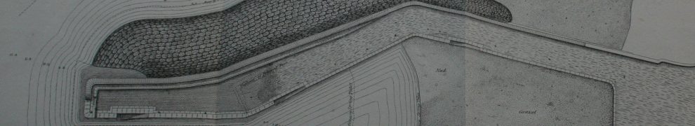
Slieve Anierin Canal and Cornashamsoge Furnace
About the year 1650, there was a furnace for smelting Iron ore in the townland of Cornashamsogue, situated on the east side of Lough Allen. The ore had to be conveyed to the furnace for a distance of about 3 miles.
For this purpose a canal was made. The canal ran by the foot of the mountain. Several rivers flow westward from the mountain into Lough Allen. The largest of these is the Stoney river, a river that becomes a roaring torrent in times of heavy rain, often overflowing its banks, and causing great destruction, to lands, crops and houses.
At the time mentioned above, about the year 1650, the water of the Stoney river was diverted into the canal. The canal then was fed principally by this river, and in a lesser degree by the other smaller rivers that ran in the same direction. All the rivers ran at right angles to the canal.
The water also supplied the power that worked the furnace. The site of the furnace can still be pointed out, and the field in which it is situated has got the name of the Furnace Meadow. This furnace was in operation about the same time as, and may have some connection with the furnace, or furnaces, at Drumshanbo, which would be about 3 miles away.
Iron ore was conveyed to the Drumshanbo furnaces by boat, on Lough Allen. The sources of supply, were, the Slieven an Iern, Ballinaglera, Arigna mountains, all situated around Lough Allen. It is thought that the town of Drumshanbo had its origin in these industries. As to the Slieve an Iern canal, there are but very meagre traces of it at the present time.
A canal built in 1650 would be a very early canal and I would be grateful for any information anyone can provide about it; please leave a Comment below if you can help. I can’t see any trace of either canal or furnace on the OSI 6″ and 25″ maps but I may not be looking for the right shapes.


I’m tempted to concentrate on the term “folklore” here and assume that as the story was passed down through generations, it became corrupted. However, as there is a possibility of truth in the story, I have posted a backink to the Mining Heritage Trust of Ireland Facebook page.
The other thought that came to mind is that as the Arigna River was used to carry coal down to Lough Allen (hence the height on the historic Mountallen Bridge which would not be needed if the river was not so used), there may be a conflating of this navigation with stories of smelting.
https://www.google.ie/maps/@54.0672516,-8.0806099,3a,75y,305.49h,83.12t/data=!3m6!1e1!3m4!1suZ3Bi5n6yxPRQHIjnU2gLA!2e0!7i13312!8i6656!6m1!1e1?hl=en
I’ll thank you for one thing, the link to the original OSI map site. I’m not very keen on the new Geo Hive application
I fear that I hadn’t been aware of the existence of the new thing until you mentioned it. bjg
Thanks. The MHTI folk might indeed have the answer. I found nothing in the Dublin Society Statistical Survey and nothing in Lewis (though that was long afterwards; furthermore I didn’t try all spelling options). bjg
The old 1″ scale maps show several west flowing streams that turn to the southwest and discharge into Lough Allen at Cormongan. It’s possible that water from the Stoney River or tributaries of the river was diverted to Cormongan along a leat.
http://maps.nls.uk/geo/explore/#zoom=14&lat=54.1069&lon=-8.0259&layers=14&b=1
The Down Survey map of Leitrim Barony appears to show a waterwheel to the south of Cormongan, probably in Cornashamsoge townland. Perhaps this was the furnace? The map of the Kiltahorke Parish (1657) shows what may be a “canal” leading from the Stoney River, north of the Parish, to Lough Allen.
http://downsurvey.tcd.ie/down-survey-maps.php#bm=Leitrim&c=Leitrim
Hi, I am gathering all references I can find to iron smelting furnaces in Ireland. I have not come across a reference to a furnace in or near this townland but then Co. Leitrim is one where I have most trouble finding information. Also, if there was a place called Furnace Meadows, I would take that as proof that a blast furnace was operating there at some time.
1650 would be rather unusual for an ironworks to be operating in Ireland outside of the east and south-east. There are no others recorded and the industry really only picks up in the 1680s. In the 1630s Charles Coote had ironworks at Doobally and Drumnelass, at the northeastern end of the lake. After that, I only know of a single reference to ironworking in the area in the 17th century (1688 Drumshanbo). Drumshanbo was active from around 1737 to 1763.
Then about the function. It would seem rather pointless to have a canal for transporting iron ore running parallel and close to a lake. A leat tapping from various rivers, on the other hand, would have made much sense
My best bet would be that there was likely a blast furnace active at that place at an unknown period. The water-way was then most likely a leat
Thank you for those — and for the links, both of which were new to me: I’m usually in the early nineteenth century, not the seventeenth, or even the eighteenth.
bjg
Hi, Paul. We met in Scarriff some years ago.
I read McLoughlin’s remarks rather differently. I assumed he meant that the canal was used to transport the raw material from the mine on the mountain westward to the works near the lake. From there, after some initial processing, it might be transported on the lake in larger batches.
My experience with turf canals suggests that many watercourses were multi-purpose. If the same applied in mining, then if a leat could be made big enough for a small boat, it would be used for that purpose. The boats might have been fairly small, much smaller than those capable of carrying forty tons, which Boate mentions Coote as using on Lough Allen. The cots that Coote used on the Nore, from Castletown to Ross and Waterford, must have been much smaller than that.
Incidentally, Wikipedia has an article on Slieve Anierin with sources and all, but the same Mr McLoughlin is the source for information on the furnace and canal.
bjg
McLoughlin does say that the ore was brought to the furnace via the ‘canal’, which was actually not so far. So this would imply smelting and no further transport of the ore.
But yes, I was thinking about the leat being used for transport as well after I posted it. So yes, perhaps very small boats or some kind of rafts or floating vessels.
That’s very interesting Alastair! I’ll have to check if there are similar ‘mills’ at known furnaces.
Adjacent to Cornashamsogue is Barnameenag, the place name translateing from “Barr na Mianach (“top of the mines”). Map suggest Barnameenagh is indeed at higher elevation (top of) Cornashamsogue townland. The native Irish had a limited vocabulary for these foreign things, so Barnameenagh might recall “the place above the mining operation thingy there”
Timber was transported via waterways to burn charcoal, and many thousands of hectares of a forest blanketed the region 400yrs ago. Deforestation and the Iron Ore industry gave birth to new place names and “Barr na Mianach” is therefore not an ancient name.
I think Cornashamsogue furnace must have existed.
Thank you very much. bjg