… what this ramp is, or at least what it was originally intended as.
Curious object [2006]

… what this ramp is, or at least what it was originally intended as.
Curious object [2006]
This site uses Akismet to reduce spam. Learn how your comment data is processed.


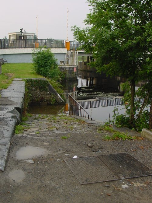
Very odd, as the design makes it all but useless for launching craft. I have a dozen questions, but no answers. On the plus side, I have a few reams of paper in the office here…
Will there be clues?
I could tell you where it is …. bjg
Yes, that might give us something to work on…………..
It’s at Tarmonbarry, just downstream of the bridge on the Roscommon (west) side of the Shannon. bjg
Was it anything to do with the swivel bridge that used to be there?
It was built around the same time, and by the same people, but it had nothing to do with the operation of the bridge. I suspect it would have been just as useful with a fixed bridge. bjg
Was it in connection with the corn mill previously here?
Alas, no. bjg
I guess any slip is an access issue, but in this case, not boats. No prizes for that, though, I know. Anything to do with the construction of the bridge?
As you say: access yes, boats no. But nothing to do with the construction of the bridge (apart from being done at the same time by the same people). Think about important Irish products. bjg
So a trade issue? For loading or offloading cargo? A slip seems an odd choice, unless it’s livestock?
Not for loading or unloading … but it is for livestock. “… a slip for watering cattle has also been constructed at the river side, immediately below the end of the south wing wall of the swivel bridge.” Seventh Annual Report of the Commissioners for the improvement of the Navigation of the River Shannon, Ireland; with an appendix Ordered, by The House of Commons, to be Printed, 24 March 1846 [153]
It was very nice of the Commissioners to build a slip, but why there [and, AFAIK, nowhere else]? This is speculation on my part, but I suspect that, as the estate agents say, location is everything and that the slip was built to serve, not any local cattle, but those who might be about to cross the river en route to Dublin or Liverpool. Tarmonbarry is on the way from Mayo and Roscommon, both cattle-rearing counties, and close to the Royal Canal terminus at Clondra, where some of the cattle might have been taken on board the City of Dublin Steam Packet Company’s cattle-carrying barges and brought to the North Wall in Dublin, for loading on to CoDSPCo steamers bound for Liverpool. [There could of course have been other carriers, and some cattle may have been walked much of the way, losing condition and having to be fattened in Meath.]
There is a book about the drove-roads of Scotland, but I haven’t found one about their Irish equivalents; I would like to know more about the business.
bjg
I stopped and studied it last weekend and I too wondered. It’s at Tarmonbarry. It was hardly designed for launching craft, it’s a bit tight for that. I think it might have been part of an original tow path from under the opening bridge for a horse to draw a boat through which was not under steam or which was unable to navigate the channel under sail. The incongruous iron railing suggests a 20th century imposition by the Local Authority to prevent drunken lugs driving their cars into the water…
Damien Maguire, Maynooth.
Sent from my iPhone
>
Thanks for that. Enjoyable mystery on a Tuesday afternoon. Was there any issue with the canal construction, perhaps, that traditional access for cattle to the river to drink had been obstructed with the construction of the canal? Or was it simply as your explanation suggests, that they needed to have a drink en route to market?
I suspect you’re right about the railing, but the ramp was to provide access for cattle to drinking water. Towpaths were generally not provided on the Shannon between Killaloe and Leitrim. bjg
No: this is all river, rather than canal, and there is access to the banks a little way downstream. In some places on the Limerick Navigation, the commissioners provided cattle access slips because otherwise the cattle broke down the banks. Some yeares earlier, small bridges were built under the towing-path embankment on the river sections, so that water could get to the cattle (or vice versa). bjg
Fascinating, as ever! A nice diversion……/.