
On 9 October 2013 minister Brian Hayes spoke in the Dáil about Shannon water levels, saying:
A meeting between the ESB, Waterways Ireland and the Office of Public Works to review the interim operating regime is due to take place shortly.
On 17 and 18 October 2013, in correspondence with Waterways Ireland, I learned that the meeting had not then taken place and that no date had been set. I have now sent WI another note asking whether the meeting has been held and, if it has, requesting a report on the proceedings and outcome.
In the meantime, I have put together two charts nicked from waterlevel.ie for Banagher and Athlone:
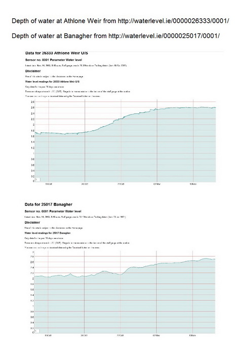
Athlone and Banagher water levels
Both of them show the levels for the last 35 days. I’m sure that more data and much more sophisticated analysis would be required to reach any reliable conclusion, but my untutored impression is that, in what has been a fairly dry autumn, keeping Lough Ree low didn’t do much to keep Banagher low. If that is so, and if I’m right in thinking that this autumn was dry (see below), the outcome would not show whether lowering Lough Ree would help in a very wet season; it may be necessary to repeat the experiment next year while performing rain dances. I would be glad, though, to have comments from more erudite folk and, if I get any information from TPTB, I’ll publish it here. In the meantime, this CFRAM PDF provides background reading.
On the dryness: Met Éireann’s monthly report for September 2013 is headed “Dry everywhere; warm and dull in most places” while that for October says “Rainfall was above average except in parts of the West, Northwest and North”. Its report doesn’t, AFAIK, specify any stations in the Shannon catchment (apart from Shannon Airport), but those to the west were generally below average while whose to the east were above; it may be that the Shannon rainfall was moderate.


Yo Brian, apart from rainfall another major influence on Banagher levels might be the sluices at Meelick. I have noticed that WI keep them closed ,bar one or two,if the weather is dry and open them all if heavy rain is forecast. Given that there are a number of shallow spots above Meelick and also Banagher,this must be a bit of a juggling exercise.Pjn
Thanks, PJ. I see that WI is now showing the Meelick level on its Netview page here but (a) it seems to use Malin Head datum whereas almost every other inland measure seems to use Poolbeg and (b) I can’t see a way of getting a graph rather than an individual measurement from it. bjg
Pingback: Lowering Lough Ree | Irish waterways history