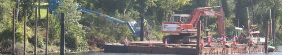
My dry docks overview page had a bad link in it, which was my fault, but I hope that’s now fixed as the Shannon Harbour dry docks

34B in the dock
page is now up. Comments, corrections and suggestions for improvements and additions will be welcome.
My dry docks overview page had a bad link in it, which was my fault, but I hope that’s now fixed as the Shannon Harbour dry docks
34B in the dock
page is now up. Comments, corrections and suggestions for improvements and additions will be welcome.
Posted in Extant waterways, Industrial heritage, Irish inland waterways vessels, Irish waterways general, Operations
Tagged 34B, 59M, acro, boats, bridge, canal, dry dock, gate, Grand Canal, grille, Ireland, Knocknagow, lock, loo, Operations, paddle, prop, rack, Shannon, sluice, Swaine, vessels, waterways, Waterways Ireland, winch
… didn’t cross the Rine, which is a river in County Clare, flowing into the estuary of the River Fergus which, in turn, joins the estuary of the River Shannon. The Rine is also known as the Quin and the Ardsollus and its downstream end is called Latoon Creek, no doubt because it flows by the townlands of Latoon North (which is to the east) and Latoon South (to the west). There is a quay there, hidden under one of the three road-bridges that cross the Latoon side by side. Sea-manure (seaweed used for fertiliser) was landed there and Samuel Lewis tells us that fifty-ton lighters were used, but more information is needed about their operations.
Read about it here.
Posted in Extant waterways, Forgotten navigations, Industrial heritage, Irish inland waterways vessels, Irish waterways general, Operations, shannon estuary
Tagged Ardsollue, boats, bridge, Clare, Clarecastle, creek, Ennis, Fergus, fertiliser, Hely Dutton, Ireland, Latoon, lighters, lost, M18, N18, pier. three German officers, quay, Quin, Rine, Samuel Lewis, sea-manure, seaweed, Shannon, turf, vessels, water level, waterways
It’s a long way from Trinity College, Dublin to the pier at Saleen on Ballylongford Creek, on the south side of the Shannon Estuary. But the college owned large amounts of land in the area, including bogs, and turf was one of the cargoes exported from Ballylongford. There was a battery on Carrig Island at the mouth of the creek and a Coast Guard Station at Saleen Pier, which was built by the Commissioners for the Improvement of the Navigation of the Shannon. Read more about Saleen here.
Posted in Extant waterways, Forgotten navigations, Industrial heritage, Irish waterways general, Scenery, shannon estuary, Steamers, The fishing trade, The turf trade, Water sports activities
Tagged Ballylongford, battery, boats, bog, bollard, Carrig Island, Coast Guard, Commissioners, Front Square, goat, Ireland, jetties, Kerry, Kilrush, Limerick, lost, Operations, potatoes, Saleen, Saleen Pier, Shannon, slipway, Tarbert, TCD, tide, Trinity College Dublin, turf, vessels, water level, withy
One beneficial aspect of the floods is that there is lots of water for kayakists. Here are some pics taken at Curragour, on the Shannon in Limerick city, on 28 November 2009.
Posted in Extant waterways, Forgotten navigations, Industrial heritage, Irish inland waterways vessels, Irish waterways general, Operations, Scenery, Water sports activities, Weather
Tagged boats, bridge, Curraghgour, Curraghgower, Curragour, ESB, falls, floods, Ireland, kayak, Limerick, Shannon, University of Limerick, vessels, water, water level, waterways, waves
Here are the Sailing Directions for the Shannon Estuary (completed before 1848) and for Lough Erne (1835-6), Lough Ree (1837) and Lough Derg (1838-9). They were compiled by Commander James Wolfe RN, who was one of those who drew up the relevant Admiralty Charts. Like the Charts, these Directions have not been updated, so boaters should not rely on them for navigation.
The Google Books Team have kindly permitted me to extract these from a larger document, which was one of those they had scanned and placed online, and to make them available (free, of course) to visitors to this site. Note that I have omitted part of the description of the smaller Lough Derg, which is not part of the connected waterways system.
After a recent visit to Lowtown, the junction between the Barrow Line and Main Line of the Grand Canal, I’ve set up a new page of photos of wooden boats at Lowtown. There are some interesting boats there, and several conversions of varying degrees of elegance. There are also some sunken boats. And there is an Artwork.
In most cases I was unable to name the boats; I would welcome information on their names of any aspect of their histories (you can leave a Comment at the bottom of the page).
Posted in Irish inland waterways vessels
Tagged boats, canal, Grand Canal, Ireland, vessels, waterways, Waterways Ireland
Here is a short page with a few photographs showing a Waterways Ireland crew at work in Athlone, where they were laying buoys to mark a course for the swimming element of a triathlon. Waterways Ireland is the main sponsor of the event and had evidently committed staff resources as well as cash.
Posted in Extant waterways, Irish inland waterways vessels, Operations
Tagged boats, Ireland, Operations, Shannon, vessels, waterways, Waterways Ireland, workboat
I’ve added four photos of Dowleys quay at Ballylynch to the Middle Suir page, two recent photos of the Dunbrody to the Tidal Barrow page, one unusual boat to the Boats that are different and numerous sailing boats (including a Romilly) to the page where you would expect to find them.
I have just put up a page about the Upper Suir navigation, from Clonmel downstream to Carrick-on-Suir. This was an extraordinarily difficult navigation, with a fall of 57′ in about twelve miles — and not a single lock of any kind. There were shallows, rapids and floods: the level of the Suir could change very quickly in response to rainfall, and the currents, bad enough at the best of times, could rapidly become extremely dangerous. It is not surprising, therefore, that the worst accident in Irish inland waterways history was the drowning of over 100 people, most of them women and children, who were travelling downstream from Clonmel to Carrick.
And this navigation was worked entirely by horse power, with up to fifteen horses employed at times to haul the boats upstream.
This account includes extracts from poems and links to old photos, as well as many, many photos of major sections of the navigation. There is also a diversion to cover the millstreams and weirs of Clonmel and there are opinions from the authors of early guidebooks for oarsmen and canoeists. However, there are undoubtedly errors and omissions, and I welcome Comments that might help to improve this account.
Posted in Forgotten navigations, Irish inland waterways vessels, Operations, Scenery
Tagged boats, canal, Ireland, lost, Suir, vessels, waterways
I’ve added photos to some of the boat pages. Several of the new photos were kindly supplied by Tina of Wasserrausch, to whom I am very grateful. The additions are:
– Traditional boats and replicas has a new photo of an Erne cot, supplied by Tina
– Waterways Ireland workboats has photos of the new vessel Inis Cealtra (I’ve already announced these) and two photos of small boats at Munster Harbour. It also has a link to a page of detailed photos of Inis Cealtra
– Non-WI workboats has photos, supplied by Tina, of ferries and workboats on Lough Erne and of two boats operated by environmental authorities
– Sailing boats has photos of the skutsje Nieuwe Zorgen, which arrived on the Irish waterways in 2008
– Wooden boats has several new photos of wooden boats photographed recently at Shannon Harbour, as well as a few better photos of boats that were already listed
– Boats that are different has one addition.
As always, if I’ve got anything wrong, or omitted anything, do please leave a Comment at the bottom of the relevant page.

