Tag Archives: Cloghan

Marty Whelan, St Saran, Colonel l’Estrange and the Tessauren Ferry

Marty Whelan, a youthful disk-jockey chap with an insignificant amount of facial hair, presents a morning programme on the wireless. One day last week, discussing traffic problems with a chap from AA Roadwatch, he considered the origin of the name of L’Estrange Bridge, whose location neither he nor his collocutor knew.

L'Estrange Bridge (2003)

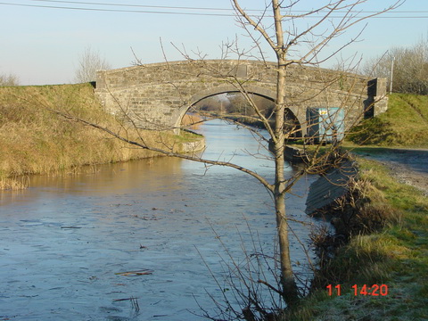
L’Estrange Bridge (2003)

It had been mentioned on this site as the location of a fatal motoring accident in December 2011 and it is, of course, a useful stopping place for those who, driving to Athlone, like to stop to consume the coffee (and any comestibles) they may have purchased in the award-winning Spar shop in Cloghan.

I emailed Mr Whelan, with a link to the location on the OSI map.

Tessauren 1

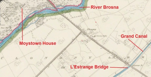
L’Estrange Bridge and Moystown House

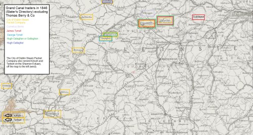
I speculated that, as the nearby Moystown House was owned by the l’Estrange family (as was Huntston or Hunstanton, across the road), the Grand Canal Company might have had to buy land from them and, with the aim of keeping the cost down, have agreed to name the bridge after the landowner (a tactic that the National Roads Authority might adopt).

I should make it clear that I have not researched the land purchases of the Grand Canal Company in the area, so this should not be taken as definitive. I note, from Fred Hamond’s Bridges of Offaly County: an industrial heritage review (for Offaly County Council, November 2005), that the date on the bridge is 1800, although the canal was not opened until 1804; as Fred says:

Most [bridges] were built before their respective stretches of canal opened […].

The Parliamentary Gazetteer of 1846 says:

The principal artificial features are the mutually adjacent demesnes of Moystown and Hunstanton, the residences of the Messrs L’Estrange, situated on the Brosna. “Though Moystown,” remarks Mr Fraser, “has not extensively diversified park scenery to boast of, and is environed by deep brown bog, there is, in the style of the house, in the arrangement of the plantations, and in the beautiful evergreen oaks and other ornamental trees which adorn the lawn, a character which carries us back to the gentlemen’s seats of the olden times. This demesne is watered by the Brosna, which pays its ample tribute to the Shannon at thetermination of the grounds, and where also the Grand Canal crosses the river in its progress to Ballinasloe.”

Lewis’s Topographical Dictionary of 1837 says that Colonel l’Estrange was living at Moystown at the time, William l’Estrange was living at Kilcummin, a little distance north of Huntston, and Major Carlton (a relative, I think) at Huntston.

A quick search suggests that the l’Estranges did occupy land there in 1800, but I cannot claim to have carried out a thorough investigation.

What was of more interest to me was that the Parliamentary Gazetteer extract was from an item headed Tessauran, Tiseran or Kilcally:

Tessauren 2

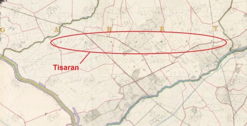
The parish of Tisaran

TESSAURAN, TISERAN, or KILCALLY, a parish in the barony of Garrycastle, 2¼ miles north-west by west of Cloghan, King’s co., Leinster. Length, south-westward, 3¾ miles; extreme breadth, 2½; area, 7,316 acres, 2 roods, 12 perches, — of which 106 acres, 3 roods, 38 perches are in the river Shannon. Pop., in 1831, 2,032; in 1841, 2,029. Houses 346. The north-western boundary is traced by the Blackwater; the south-western boundary, by the Shannon; and the south-eastern boundary, by the Brosna. All the northern district, part of the eastern, and most of that along the Blackwater, are bog; much of that along the Shannon is lowland meadow; and most of the remainder is dry limestone land, pleasant in appearance, and possessing a considerable aggregate of embellishment.

Some time ago, I asked here about Tessauren Ferry, but had no response. I found the term in F E Prothero and W A Clark eds Cruising Club Manual: A New Oarsman’s Guide to the Rivers and Canals of Great Britain and Ireland George Philip & Son, London 1896. His entry for the Grand Canal included this at 79¼ miles from Dublin:

Entrance into the Shannon at Tessauren Ferry.

I have not seen the term used anywhere else. The ferry is of course that provided by the Shannon Commissioners to enable horse-drawn boats to cross the Shannon to the Ballinasloe Line of the Grand Canal. It would be nice to find other instances of the use of Prothero’s term.

Tessauran, Tisaran, Tiseran, Tessauren (and perhaps there are other variants) is the name of the parish north-east of the junction between the Brosna and the Shannon. It is odd that the ferry’s eastern departure point was actually outside the parish, because the Brosna was the boundary and the ferry started from the south side of the canal and the Brosna.

Tessauren 3

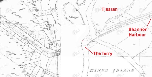
Tisaran parish and the ferry

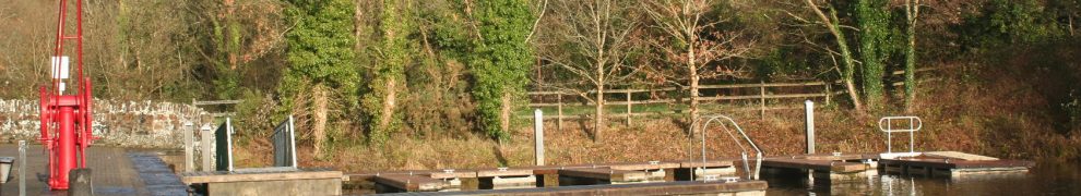
The other link I had not made was that between Tessauren and St Saran, whose well I photographed some years ago, which means that I was on the grounds of Moystown House.

Tessauren 4

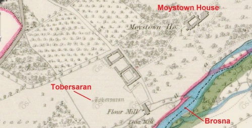
St Saran’s well (Tobersaran)
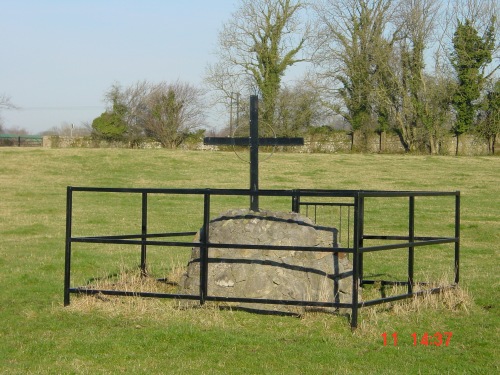
 

St Sarans Well near Shannonbridge 03_resize

St Saran’s well

St Sarans Well near Shannonbridge 04_resize

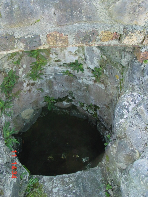
Looking into the well


So one mystery solved, as an accidental result of a remark on the wireless, but more information about the use of the term Tessauren Ferry would be welcome.

My OSI logo and permit number for website

Canal carrying 1846: the Grand Canal

Isaac Slater’s Directory[i] of 1846 lists those carrying goods on inland waterways. Most of the carriers on the Grand Canal, which runs from Dublin to the River Shannon with various branches, claim to serve a modest number of places, but Thomas Berry & Co have a very lengthy list. So long is their list that it will require two maps to show all the places they served, with a third map for the rest of the carriers.

Note that the maps are from the 25″ Ordnance Survey map of around 1900 rather than the 6″ of around 1840: I used it because it was clearer, but it shows features (eg railway lines) that were not present in 1846.

There may be some cases where I have misidentified a destination; I would be grateful to have my attention drawn to such cases.

Click on a map to get a slightly larger version.

Thomas Berry & Co

Thomas Berry & Co midland and south routes

Thomas Berry & Co midland and southern destinations (OSI)

The canal runs from Dublin, at the top right, left (roughly west) through Tullamore to Shannon Harbour, where it meets the river; there was an extension to Ballinasloe on the far side of the Shannon. Berrys served places along the canal and several others fairly close to it, but it looks to me as if there were three routes by road beyond that:

  • via Banagher (which has a bridge across the Shannon) to Eyrecourt and Killimor
  • from Ballinasloe to Loughrea and district and then south-west to Ennis in Co Clare
  • perhaps from Tullamore to Birr [Parsonstown], Roscrea (including Shinrone, Cloughjordan and Borrisokane) and Templemore.

There are also two outliers for which I can think of no plausible explanation: Baltinglass and Wexford. Perhaps their inclusion was a mistake. Certainly Berrys, like John M’Cann & Sons on the Royal Canal, seem to have had extensive road networks (perhaps using car-owning subcontractors?) to supplement their water-borne routes, but I don’t see why they would take on a route no part of which could sensibly have been conducted by inland navigation.

The next map shows the north-western destinations served by Berrys.

Thomas Berry & Co western routes

Thomas Berry & Co north-western destinations (OSI)

You can see that their network covered much of County Roscommon and went almost as far west into County Galway as it was possible to go; it also extended northwards into County Mayo.

I have not attempted to check what industries might have made these towns and villages worth serving. Berrys certainly seemed keen to take as much as possible of the traffic from west of the Shannon towards Dublin — excluding such of it as went by the Royal Canal: it is interesting to compare these maps with that for M’Cann on the Royal.

Finally, note that along the canal itself Berrys listed only destinations towards the western (Shannon Harbour) end: it seems likely that the roads took the valuable traffic from the eastern end into Dublin. There were no doubt turf boats taking fuel in from closer to Dublin, but they were not general carriers.

Other carriers

Now for the rest of the carriers.

Grand Canal carriers 1846 excl Thomas Berry

Grand Canal carriers 1846 excluding Thomas Berry (OSI)

I have included the Shannon here as well as the Grand Canal; however I have covered the Barrow Line of the Grand Canal, as well as the navigable rivers Barrow, Nore and Suir, in a separate post. Of the carriers listed here, only the City of Dublin Steam Packet Company [CoDSPCo] (which employed horses to pull its boats on canals) ventured on to the Barrow Line, serving Portarlington and Mountmellick.

Berrys and the CoDSPCo were by far the largest firms on the Grand. I don’t know the size of the Berrys fleet, but the CoDSPCo had 52 barges in addition to its Shannon (and Irish Sea) steamers. Note that only on the middle Shannon, around the junction with the Grand Canal, and at Ennis did the two firms serve the same destinations: the CoDSPCo seems to have had the lower Shannon trade to itself.

With one exception, all the carriers, including Berrys, had Dublin depots at Grand Canal Harbour, James St; the Grand Canal Docks at Ringsend, joined to the Liffey, were not mentioned.

The exception is Hugh Gallagher, whose only listed destination was Athlone. It would be interesting to know how he served Athlone: whether by road or by water and, in the latter case, whether he used a steamer. I do wonder whether Hugh Gallagher might be the same person as the Hugh Galaghan (also Gallaghan) who served Philipstown [now Daingean], Tullamore and Shannon Harbour.

George Tyrrell is another who is listed with but a single destination, Banagher, whereas James Tyrrell is listed as serving Tickneven, Philipstown, Tullamore — and Edgeworthstown, which must be a mistake as it is closer to the Royal Canal.

Finally, Cornelius Byrne is shown as serving two destinations: Philipstown and Kilbeggan (which has its own branch off the main line of the canal).

Other information

A little extra information is available from the entries for towns other than Dublin in the Directory:

  • Naas has its own branch from the main line of the canal, but the directory says that “TO DUBLIN, there are Boats, as occasion require, but they have no fixed periods of departure.”
  • Edenderry also has its own branch, short and lock-free, but there is no mention of its being served by trade boats
  • Kilbeggan, with a longer, leakier, lock-free branch, was served by the CoDSPCo’s and Thomas Byrne’s boats travelling to Dublin three times a week. Is this Thomas Byrne related to the Cornelius Byrne mentioned above? It seems that Byrne went only eastward for only the CoDSPCo’s boats went westward (to Shannon Harbour, Ballinasloe and Limerick) two or three times a week
  • at Banagher, Fleetwood Thomas Faulkner of Main Street was the CoDSPCo agent; a downstream steamer left Shannon Harbour after the [passenger] boat from Dublin arrived and called at Banagher’s Bridge Wharf; an upstream steamer from Limerick called every afternoon at 3.00pm and met the night boat travelling to Dublin by the Grand Canal. I presume that this happened on every day except Sunday.

More

As far as I know, little has been written about the carrying companies, especially those of the nineteenth century. I would be glad to hear from anyone who can correct, supplement or comment on this information.

My OSI logo and permit number for website


[i] I Slater’s National Commercial Directory of Ireland: including, in addition to the trades’ lists, alphabetical directories of Dublin, Belfast, Cork and Limerick. To which are added, classified directories of the important English towns of Manchester, Liverpool, Birmingham, Sheffield, Leeds and Bristol; and, in Scotland, those of Glasgow and Paisley. Embellished with a large new map of Ireland, faithfully depicting the lines of railways in operation or in progress, engraved on steel. I Slater, Manchester, 1846