As a preliminary to increasing coverage of the old Limerick Navigation, I have improved the section’s top-level page. I added maps of the separate sections of the navigation and distances (in eighths of miles) from Prothero and Clark.

Dromaan at night (December 2011)
Posted in Extant waterways, Ireland, Irish waterways general, Natural heritage, Scenery, Shannon, waterways, Weather
Tagged boats, Clare, Dromaan, Ireland, Lough Derg, night, Shannon, weather

From Twomilegate December 2011
Posted in Ashore, Extant waterways, Ireland, Irish waterways general, Natural heritage, Scenery, Shannon, waterways, Weather
Tagged birds, Ireland, Lough Derg, Shannon, sky, Twomilegate, waterways, winter
… will be delighted to hear of today’s victory by Colin Becker, the result no doubt of many years of practice at rally table quizzes.
We are reminded of the Christmas cartoon in Private Eye some years ago, depicting two choirboys, one saying to the other “I can’t believe it’s not Rutter”.
Posted in Ashore, Economic activities, Ireland, Non-waterway, People, Steamers, waterways
Tagged Colin Becker, IWAI, John Rutter, Lough Derg, Lyric FM
The SS John Randolph, described as “America’s first successful iron ship in commerce”, is commemorated by a historical marker in Savannah, Georgia, USA.
The John Randolph was one of the first six iron vessels built by Lairds of Birkenhead (later merged into Cammell Laird). The other five were built for use on the River Shannon.
Posted in Ashore, Built heritage, Charles Wye Williams, Economic activities, Engineering and construction, Extant waterways, Foreign parts, Industrial heritage, Ireland, Irish inland waterways vessels, Irish waterways general, Operations, People, Politics, Restoration and rebuilding, Shannon, shannon estuary, Sources, Steamers, The cattle trade, Tourism, waterways, Waterways management
Tagged Birkenhead, boats, Charles Wye Williams, Clare, Dublin, estuary, Fergus, Garryowen, Georgia, Grand Canal, Ireland, iron, John Randolph, Killaloe, Lady Lansdowne, Laird, Limerick, lock, Lough Derg, Operations, Savannah, Shannon, steam, tug, vessels, waterways
… nor any drop to drink. I had not realised that WI turned off the water supply at public harbours for the winter — or at least at some of them: Dromineer and Dromaan. I must check when visiting others.
Posted in Ashore, Economic activities, Engineering and construction, Extant waterways, Ireland, Irish waterways general, Operations, Shannon, Tourism, Water sports activities, waterways, Waterways management, Weather
Tagged Dromaan, Dromineer, Ireland, Lough Derg, Shannon, tap, water, Waterways Ireland
The Mid-West Regional Authority is seeking tenders for developing a “Signage Audit & Strategy for the Lough Derg Destination Area”.
The strategy is to cover
the Lough Derg Destination Area from Portumna to Ballina/Killaloe including the major settlements within this boundary incorporating both sides of Lough Derg ….
It involves auditing existing signposts within three miles of Lough Derg, consulting “key stakeholders” and developing a new signposting plan for the region. The new signage is to guide visitors to and through the Lough Derg Destination Area, to benefit the “local host community” and to provide a “comprehensive, branded, co-ordinated signage strategy for the Lough Derg Destination Area which will also inform and direct signage in the future”.
Posted in Ashore, Economic activities, Engineering and construction, Extant waterways, Industrial heritage, Ireland, Irish waterways general, Natural heritage, Non-waterway, Operations, People, Politics, Scenery, Tourism, waterways, Waterways management
Tagged Clare, destination area, Ireland, Limerick, Lough Derg, Mid-West Regional Authority, Shannon, sign, signage, Tipperary, tourism, waterways
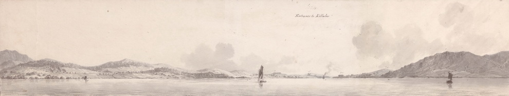
Drawings now uploaded. Much more activity in these than in the Lough Ree equivalents, with steamers towing barges, turf boats, the surveyors’ cutter and other excitements.
Posted in Ashore, Built heritage, Charles Wye Williams, Economic activities, Engineering and construction, Extant waterways, Industrial heritage, Ireland, Irish inland waterways vessels, Irish waterways general, Natural heritage, Operations, People, Politics, Scenery, Sources, Steamers, The cattle trade, The turf trade, Tourism, waterways, Waterways management
Tagged Admiralty, Beechey, boats, Charles Wye Williams, chart, Clare, cutter, drawing, Grand Canal, Holy Island, hydrographic, Ireland, Killaloe, Lady Lansdowne, Limerick, Lough Derg, Nutgrove, Operations, quay, Shannon, survey, turf, vessels, waterways, Williamstown, Wolfe, workboat
… their true origins revealed (up to a point, Lord Copper).
Posted in Ashore, Built heritage, Engineering and construction, Extant waterways, Ireland, People, Scenery, Sources, Tourism, waterways
Tagged Brahman, Buddhist, Devenish, Erne, Hindu, Holy Island, Ireland, Kali, lingam, Lough Derg, Lough Neagh, phallus, Ram's Island, round tower, Shannon, Shiva, Siva, waterways

