Fertilising the countryside
Fertilising the countryside
Posted in Ashore, Built heritage, Economic activities, Engineering and construction, Extant waterways, Industrial heritage, Ireland, Irish inland waterways vessels, Operations, Sources, The cattle trade, waterways, Waterways management
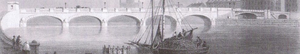
Tagged barge, boats, bridge, canal, Dublin, Grand Canal, Ireland, Operations, waterways
Today’s Irish Times reports on yesterday’s launch of a report called Ireland’s climate: the road ahead [92.9 Mb 103 page PDF here]. The report predicts:
Chapter 10 “Climate change and catchment hydrology” covers river flows.
Met Éireann’s report on summer 2013 [2 page PDF] is available here; rainfall was down [on the 1981–2010 average] at all stations except Valentia; temperature was up everywhere and so was sunshine. So perhaps we’ll have a wet winter to look forward to.
Posted in Drainage, Economic activities, Engineering and construction, Extant waterways, Ireland, Irish waterways general, Natural heritage, Operations, Politics, Safety, Sea, Shannon, Sources, Tourism, waterways, Waterways management, Weather
Tagged climate, flood, hydrology, Ireland, rain, summer, sunshine, temperature, water level, weather
It seems possible that, at some stage in the late eighteenth century, there was a plan that would probably have destroyed Clonmacnoise.
There exists A Map of the River Shannon from Athlone to Killaloe, Surveyed by John Killaly 1795, which contains much of interest. I do not have permission to reproduce it here, but here is the section around Clonmacnoise from the ~1840 OSI 6″ map.
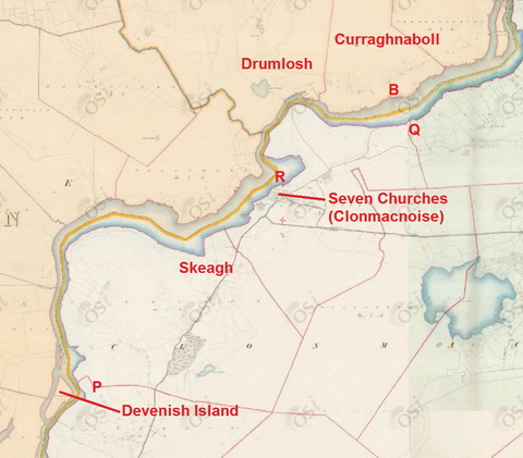
Clonmacnoise OSI ~1840
I have marked on the map some of the placenames used by Killaly.
The legend reads:
[…]
B. Ford least water 4F 6J [which I take to mean 4′ 6″]
[…]
From Q to P the proposed Canal is ¾ Mile shorter than the River.
From Q to R [the proposed Canal] is ¾ Mile shorter than the River.
It seems therefore that, in 1795, someone was considering shortening the Shannon by digging one of two possible canals to cut off peninsulas along the east bank. Given the narrowness of the stretch between the esker and the river, I suspect it would have been impossible to dig either of them without destroying Clonmacnoise.
I would like to know more about the proposal and about why it was abandoned.
Incidentally, some folk prefer the spelling Clonmacnois but the Placenames Database of Ireland uses Clonmacnoise.
![]()
Posted in Ashore, Built heritage, Economic activities, Engineering and construction, Extant waterways, Industrial heritage, Ireland, Operations, People, Shannon, Sources, Uncategorized, waterways, Waterways management
Tagged canal, Clonmacnoise, Devenish Island, Drumlosh, Ireland, John Killaly, Operations, Shannon, waterways
Folk knowledgeable about canal engineering and artefacts might be able to contribute to a current discussion, over at the Helpful Engineer’s website, of the Four Pots overflow and the side chambers at Lock 16 (Digby Bridge) on the Grand Canal.
Posted in Ashore, Built heritage, Drainage, Economic activities, Engineering and construction, Extant waterways, Industrial heritage, Ireland, Operations, Restoration and rebuilding, Sources, waterways, Waterways management
Tagged boats, bridge, canal, Digby Bridge, Dublin, Four Pots, Grand Canal, Ireland, Landenstown, Liffey aqueduct, lock, Lock 16, lost, Operations, overflow, Sallins, side-chambers, vessels, water level, waterways, weir
Waterways Ireland is warning of low water levels on Lough Ree. You can see here how the level at Athlone Weir has changed over the past 35 days.
Posted in Ashore, Built heritage, Drainage, Economic activities, Engineering and construction, Extant waterways, Industrial heritage, Ireland, Operations, Politics, Safety, Shannon, Sources, Tourism, Water sports activities, waterways, Waterways management, Weather
Tagged Athlone, boats, drought, floods, flow, Ireland, Lough Ree, Operations, Shannon, water level, waterways, Waterways Ireland, weir
The Helpful Engineer’s always-interesting blog today discusses an overflow mechanism on the Grand Canal.
Posted in Ashore, Built heritage, Drainage, Economic activities, Engineering and construction, Extant waterways, Industrial heritage, Ireland, Operations, Restoration and rebuilding, Sources, waterways, Waterways management
Tagged canal, Grand Canal, Ireland, overflow, water level, waterways, Waterways Ireland
Messrs Build.ie draw my attention to the formation of an Irish branch of the Visitor Safety in the Countryside Group, with members including the State Claims Agency, the OPW, Coillte, Waterways Ireland and the Department of Environment, Community and Local Government. The matter was mentioned in a Dáil written answer on 16 July 2013 and there is a ministerial statement on the formation here including this:
[…] it is essential that these visitors have safe access to our valuable assets […].
There is a list of VSCG members here. It will be nice for the Irish members to be able to converse with those from Manx National Heritage without having to use English, but the Waterways Ireland delegates will no doubt be disappointed that the Scottish bodies don’t seem to give much attention to the Scots language.
One of the VSCG case-studies is about Gas Street Basin in Birmingham; Waterways Ireland may be thinking about its applicability to the Grand Canal docks in Ringsend.
The involvement of the State Claims Agency suggests that the concern for visitors’ safety is not entirely altruistic: that the members may wish to keep down the costs of legal claims against them. Nothing wrong with that: it is in the interests of the citizenry that costs be kept down; that means managing risks and protecting against vexatious claims. If that isn’t done, there is a danger that public access to these bodies’ estates might be restricted.
Posted in Ashore, Built heritage, Drainage, Economic activities, Engineering and construction, Extant waterways, Foreign parts, Industrial heritage, Ireland, Irish waterways general, Natural heritage, Non-waterway, Operations, People, Politics, Restoration and rebuilding, Safety, Shannon, Sources, Tourism, Water sports activities, waterways, Waterways management
Tagged estate, Ireland, liability, Operations, risk, visitor, waterways, Waterways Ireland
I don’t really know much about politicians, local or national, but I presume that, in the summer recess, they retire to their country estates for a bit of huntin, shootin and fishin, with breaks for trips to agreeable parts of foreignlandia (Tuscany, perhaps) and with occasional visits from other gentlefolk.
At any rate, something distracts them and keeps them quiet, but summer is now giving way to autumn and, er, innovative suggestions are coming thick and fast from politicos anxious to get other people to contribute to social and economic development in their constituencies (or to get reelected, whichever comes first).
So we have one who wants a walkway across Meelick Weir and another who wants a riverbus service on the Park Canal in Limerick.
Meelick turns up in another story from the past week, by John Mulligan in the Irish Independent. But despite the silly headline and subhead, the body of the article is a thorough and balanced account of flooding on the Shannon. Mr Mulligan is to be commended.
Posted in Ashore, Built heritage, Drainage, Economic activities, Engineering and construction, Extant waterways, Industrial heritage, Ireland, Irish inland waterways vessels, Irish waterways general, Natural heritage, Non-waterway, Operations, People, Politics, Restoration and rebuilding, Safety, Scenery, Shannon, Sources, The cattle trade, Tourism, Water sports activities, waterways, Waterways management, Weather
Tagged floods, flow, Ireland, Limerick, lock, lost, Meelick, Operations, Park Canal, Shannon, water level, waterways, Waterways Ireland
.. of anybody’s money, even in sterling. An Abebooks trader is selling a copy of the Pilot Book of the River Shannon for £10. This is a short (~44-page) book, with no photos but an interesting map in the back (be VERY careful unfolding it: it has three horizontal sections, ie two horizontal folds), produced by Bord Failte with directions by the IWAI. It is undated, but I think it’s from the 1950s. Anyone interested in the history of the development of the Shannon for recreational rather than commercial purposes might be interested.
I have no commercial or other link with the seller.

