Tag Archives: Clonmacnoise

Holiday tours in Ireland VII

On Lough Derg

There are two Lough Dergs in Ireland. One is in the County of Donegal, within four and a half miles of Pettigoe, and is celebrated for its St Patrick’s Purgatory. The lake is but six miles long and four miles broad, and can hardly vie for scenery with its namesake in the south.

In order to reach this, probably one of the most exquisitely beautiful loughs in Ireland, it is necessary to make for the town of Killaloe. This can be done by leaving Euston at a quarter-past ten at night, when Killaloe is reached by 3.10 the following afternoon; or should the tourist prefer the Irish mail, he can leave at a quarter to nine in the evening and arrive at Killaloe at half-past eleven the following morning.

Few Irish towns contain so many antiquarian relics, combined with such beautiful scenery, for Killaloe stands on a hillside tufted with wood and surrounded by mountains. The old cathedral occupies the site of a church founded by St Dalua, in the sixth century. The present building dates from the twelfth century, with a central square tower whose effect is somewhat spoiled by a  modern crown. Its gem is a Hiberno-Romanesque doorway, which has, unfortunately, been blocked into the south wall of the nave. The precincts also contain a small stone-roofed church, said to date as far back as the sixth century.

The fishing is generally extremely good, though many prefer Castleconnell, some five miles to the south on the road to Limerick. In any case few portions of the United Kingdom furnish better salmon fishing than that reach of the river Shannon that lies between Killaloe and Castleconnell.

Lough Derg must, however, remain the greatest attraction of the district. It is twenty-three miles in length, and varies in breadth from two to six miles. Nothing can surpass the loveliness of the scene, especially on a fine summer’s day. On the one side the well-wooded and smiling hills of Limerick and Tipperary, where Thomthimia, with its slate quarries, slopes down to the water’s edge; while on the other the darker and more rugged mountains of Slieve Bernagh, Ballycuggeren, and the Crag form the most effective contrast.

Kincora was once the residence of Brian Boroimbh, King of Munster, and its magnificence was long the main theme of the ancient bards. But little now remains of the ancient palace beyond a long circular earthen fort, with a single vallum some twenty feet in height.

Inishcaltra or the Holy Island is, however, well worth a visit, and for this purpose it would be better to utilize the local service from either Scariff or Killaloe to Mountshannon, which faces the island. It possesses a round tower some eighty feet high, and seven churches, or cells, and oratories, the most remarkable of which is that of St Caimin, originally erected by him in the seventh, but subsequently rebuilt by Brian Borombh in the tenth century.

Scariff may this year be approached by steamer, and is a very prettily situated village, within access by road of Woodford, in County Galway, and Ennis in County Clare. The steamer then crosses the lake to Dromineer, at the mouth of the Nenagh river, where the ruins of the castle stand out with such picturesque effect. The bay is one of the most popular resorts, both of the angler and of the yachtsman; for to the latter it has earned a well-deserved reputation for its annual regatta.

The steamer then stops at Williamstown while a boat from Kilgarvan occasionally lands passengers and conveys them to the steamer. As soon as the new jetty has been constructed by the Board of Works, Woodford will be equally accessible; but there is no doubt that the approach to Portumna pier at the head of the Lough, lying as it does between the well-wooded demesnes of Portumna Castle on the one side and Belleisle and Slevoir on the other, presents one of the finest pictures that the lake discloses, for there we see the most striking contrast between the tame verdure of the river Shannon and the bold mountain scenery of Lough Derg.

It would be tedious to dwell on the varied beauties of those innumerable seats that dot the shores of the lake on all sides; suffice it to say that few parts of the United Kingdom present as many diverse attractions as this wide expanse of water. Much as one may appreciate Loch Lomond, Loch Maree, or the Caledonian Canal, this Irish lough certainly surpasses them; and much gratitude is due to the Shannon Development Company for bringing within such easy access of the average tourist a wealth of scenery that certainly equals, if it is not finer, the finest spots that either Scotland, Norway, or Switzerland can offer.

This is, however, but half the trip from Killaloe to Athlone. Portumna is chiefly remarkable for the ruins of a Dominican priory founded in the thirteenth century, as well as for the Castle, the property of Lord Clanricarde, in which he has not resided since his succession to the estate. The village of Lorrha, three miles further up, also contains the ruins of a Dominican abbey, an oblong pile 120 ft long, as well as a castle and two old ecclesiastical buildings called by the peasantry the English churches, owing to their having been built by Norman settlers.

The river now assumes a totally novel character, winding by graceful curves through low-lying but rich meadow lands. Their luxuriant appearance is largely due to the fact that they are usually submerged under the waters of the river during the winter months.

Meelick Abbey is next passed. It was founded by the Franciscans in the twelfth century, and was at one time a sumptuous structure, but is now a roofless and mouldering ruin; and a beautiful pillar which formerly supported the arches on the south side has been torn away with ruthless vandalism, in order to make headstones for the graves in the cemetery.

Banagher can boast of a fine stone bridge, opened some fifty years ago to replace the preceding structure, which displayed no less than twenty-three arches of various forms, with massive piers between, and was so narrow that only one carriage could pass at a time.

Shannon Harbour is best known from the description of its hotel in Lever’s Jack Hinton, but that building is now let in tenements. Shannon Bridge is one of the three fortified passes built to guard the Shannon, and is but four miles from Clonfert, whose cathedral, now being restored, contains one of the finest Hiberno-Romanesque doorways to be found in the three kingdoms.

Few spots, however, offer greater attractions to the antiquary than do the celebrated seven churches of Clonmacnoise. The most remarkable of these are the Diamhliag Mhor or Great Church, which dates from the fourteenth, and Fineens Church, built in the thirteenth century. The former was originally the work of Flann, King of Ireland, in 909, and contains several bits, more especially the sandstone capitals of the west doorway, that may be traced to the earlier period. Besides these churches, there is much to be seen at Clonmacnoise, which includes among its ruins the episcopal palace and castle of the O’Melaghlins, a nunnery, two round towers, Celtic crosses, and inscribed stones. The grand cross, formed of a single stone 15 ft high and elaborately carved, surpasses every other in beauty of execution and elaborate detail.

Though the tourist may gaze upon Clonmacnoise as he approaches and leaves it and enjoys a particularly fine view of its beauties as he passes by the curve of the river on whose banks it is situated, no provision has yet been made to enable him either to land or to make a closer acquaintance of its many beauties as he passes by. This is due to the refusal on the part of its proprietor to meet the proposals of the company. It is, however, to be hoped that more favourable terms may be made in the future, as the traveller must now proceed straight to Athlone and visit the ruins from there either by road or by water.

Much more might be said of Lough Derg as well as of the Shannon from Killaloe to Athlone. Fair hotel accommodation may be obtained at Killaloe, Dromineer, Portumna, and Athlone at from eight to nine shillings a day. Lodgings can also be procured at Killaloe, where the proprietors have learned to cater for the requirements of those anglers who frequent this highly-favoured spot.

Return tickets may be obtained from Euston to Killaloe by the North Wall at
£4 13s 6d first, £2 16s second, and £2 third class. Lough Derg may also be visited from Athlone by the Midland Great Western Railway from Broadstone. The fares by Kingstown and the mail are somewhat dearer.

Pall Mall Gazette 1 August 1898

From the British Newspaper Archive run by Findmypast Newspaper Archive Limited, in partnership with the British Library.

Notes from the north

Some observations from a trip to the hyperborean regions.

Navigation

The 2015 edition of Shannon Leisure Development Company’s Navigational Guide to the Shannon and Erne Waterways includes the numbers of some of the markers; I found that helpful, especially on the longer river stretches.

The Guide is wrong about Clonmacnoise: there is no water supply. At Hodson Bay, a suggested course appears to cross a shoal.

Eh?

Eh?

This was the first marker I noticed with a suffix to its number; I presume that means it’s a new marker.

Boxty

As far as I know, boxty is the only contribution made by the north midlands to world cuisine. We bought several varieties in Lanesborough, and jolly good they were too; I regret that I did not record the manufacturers’ names so that I could provide links to their websites.

However, boxty was not the only comestible to be found north of Portumna Bridge. Shannon Crafts and Coffee Dock in Athlone, on The Strand across the river from the lock, provides excellent cakes; boaters can tie up outside and stock up.

TripAdvisor folks liked it too.

Had I been there on a Saturday, I’d have had bratwurst.

Shannon Crafts and Coffee Dock

Shannon Crafts and Coffee Dock

The Em’raldstar Galactica

Les grands bateaux de Monsieur Thibault must have been breeding: we met several of the things.

Emraldstar Galactica 2015 01_resize

It’s big …

Emraldstar Galactica 2015 03_resize

… and, I’m told, luxuriously fitted out …

Emraldstar Galactica 2015 04_resize

… with good outdoor space on the roof …

Emraldstar Galactica 2015 02_resize

… and it accelerates quickly and smoothly from rest, suggesting a good underwater shape …

… but I still think it’s the boating equivalent of the SsangYong Rodius.

Work in progress

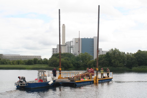
Geotechnical investigation works on the N63 bridge at Lanesborough were being carried out from this pontoon, which was assembled at Hanleys Marina at Ballyleague.

Moving the pontoon into position

Moving the pontoon into position

And here’s a Waterways Ireland boat, a Pioner I think, returning upstream to its launch site at Meelick Quay. Perhaps it had been investigating the possibility of providing berths near Meelick village.

WI Pioner

WI Pioner

Wrecks?

Iskeraulin wreck 03_resize

On the Iskeraulin shoal on Lough Ree

Copy of Boat ashore between Blackbrink and Galey bays

On shore between Blackbrink and Galey bays

I don’t know anything about either of these vessels. The second might, I suppose, have been careened for work on its hull.

Out to lunch

The closing of locks at lunchtime has got to stop.

At Meelick, on a windy day, the lower gates were open at lunchtime and two boats were blown forward on to the sill. There, and at Athlone, the waiting pontoons and quays are utterly inadequate to the volume of traffic. Two boats occupied the whole of the Athlone pontoons and only two boats (one a barge) were able to fit on the quay wall. The combined length of boats waiting was about two and a half times the length available for tying to.

Athlone waiting pontoons

Athlone waiting pontoons

Why is it not possible to have staggered lunchtimes? Or to come up with some other arrangement that puts the interests and the safety of the boaters first?

Oddities

Is this a waterside thunderbox or privy?

Perh privy above Athlone_resize

Outdoor sanitation above Athlone?

In the next photo, the small white sign in the middle says “No shooting”, which is about tweetiebirds rather than citizens. But what is the long-stemmed mushroom on the right? It looks like those gas thingies youo see scattered around the countryside, presumably to provide shelter while you strike a match to light your pipe, and there’s another on the other side of the river. Does that mean that there’s a gas pipe under the river? Or what?

Mushroom_resize

What’s the white thing on the right?

Imperfections

The pale patch of concrete suggests that the corner bollard is missing at the quay below the bridge in Shannonbridge. That makes the short angled section of wall very difficult to use.

Missing bollard at Shannonbridge_resize

Missing bollard?

At Portrunny, some of the timber edging to the pier has rotted; it may be a trip hazard.

Portrunny pier edge 2015_resize

Portrunny pier

The taps on Portrunny pier defeated us. I would be grateful to anyone who could give me the specification of the adapter required to connect these taps to standard garden/boat hoses.

Portrunny tap

Portrunny’s giant taps

Back on Lough Derg, we found that a barrier had been erected at the end of the pier at Rossmore.

Rossmore barriers 01

Rossmore

This barrier makes the end of the pier unusable by boats. I have twice seen the end used when strong winds, and waves rolling into the bay, made conditions dangerous.

On one occasion a boat, pinned against the outer (upwind, exposed) side of the pier, worked around to the other side with ropes around the end of the pier; the barrier would have made that manoeuvre impossible.

On another, again with wind and waves coming into the bay, and with the head of the T occupied by other boats, a boat tied to the end of the pier, with its bow into the waves, using strong ropes from bow and stern to bollards along the pier. Again, the barrier would have made that impossible.

Rossmore barriers 02

The barrier

I do not know whether such considerations affected the decision to erect this barrier. If they did not, I suggest reconsideration.

Enterprise

Romaris in Athlone

Romaris in Athlone (no, no: I took this one)

Romaris Motor Yacht is offering upmarket cruises in Athlone. And Baysports water park in Hodson Bay seems to attract favourable reviews.

Richmond Harbour

Finally, some thoughts on Richmond Harbour, our terminus ad quem. It is quite a delightful place and Waterways Ireland has done much to improve the amenities and maintain its appearance. Furthermore, Paddy, the patroller who let us up into the harbour, is helpful, friendly and enthusiastic about the Royal Canal.

But what a pity that WI doesn’t do more to promote both Richmond Harbour and the Royal Canal.

First, the Guide might usefully include Paddy’s phone number so that boaters, especially those (like hirers) without lock keys, might be enabled to get into the harbour. The numbers given on p15 don’t include Paddy’s.

Second, the text of the Guide might be updated: it makes it clear (p7) that some hire boats are allowed to use the Grand Canal but makes no equivalent statement about the Royal.

Third, WI might do more to establish an identity for Richmond Harbour itself, with information about its history, layout, buildings and other features. Maybe there was an information display; if so, I missed it.

Fourth, WI might provide information at Richmond Harbour (and perhaps elsewhere) to encourage boaters to venture even a few miles up the Royal. Such information might say what’s where (village X is Y miles/Z hours away), why X is worth a visit, what help is available, where a boat can turn, why it’s worth doing, what boaters should watch out for (mainly, I imagine, weed on prop or in filters). Or perhaps the RCAG or IWAI could do that.

Fifth, folk who use Richmond Harbour for free parking should find their boats below (or even above) the 45th Lock, thus leaving more space for visiting boats.

Boats arrive at the end of the Royal Canal; the canal itself, and the Harbour, should be promoted to them.

Incidentally, the Clondra Canal needs traffic lights: the cheerful and inventive keeper does his best with hand signals, but the systemn is scarcely foolproof. And it would be useful to have something (other than trees) to tie to at either end of the canal.

Weather

There were days to make Tim O’Brien eat his heart out. But some really bad days that are likely to damage next year’s tourism. I’ll get to the traffic figures anon.


Who saved Clonmacnoise?

It seems possible that, at some stage in the late eighteenth century, there was a plan that would probably have destroyed Clonmacnoise.

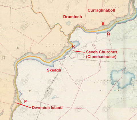
There exists A Map of the River Shannon from Athlone to Killaloe, Surveyed by John Killaly 1795, which contains much of interest. I do not have permission to reproduce it here, but here is the section around Clonmacnoise from the ~1840 OSI 6″ map.

Clonmacnoise OSI ~1840

Clonmacnoise OSI ~1840

I have marked on the map some of the placenames used by Killaly.

The legend reads:

[…]

B. Ford least water 4F 6J [which I take to mean 4′ 6″]

[…]

From Q to P the proposed Canal is ¾ Mile shorter than the River.

From Q to R [the proposed Canal] is ¾ Mile shorter than the River.

It seems therefore that, in 1795, someone was considering shortening the Shannon by digging one of two possible canals to cut off peninsulas along the east bank. Given the narrowness of the stretch between the esker and the river, I suspect it would have been impossible to dig either of them without destroying Clonmacnoise.

I would like to know more about the proposal and about why it was abandoned.

Incidentally, some folk prefer the spelling Clonmacnois but the Placenames Database of Ireland uses Clonmacnoise.

My OSI logo and permit number for website