Category Archives: Built heritage

The River Shannon and its Shrines

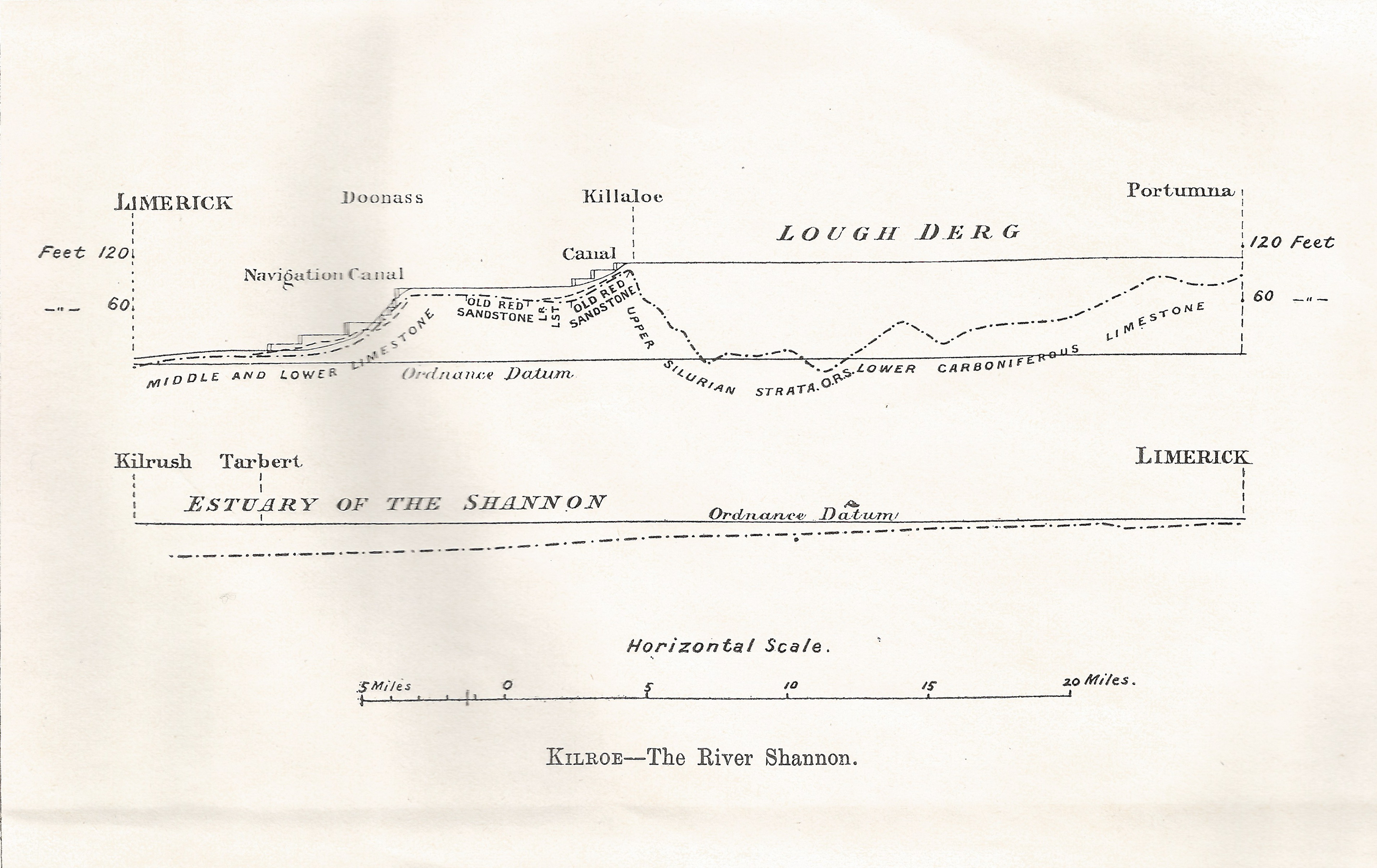
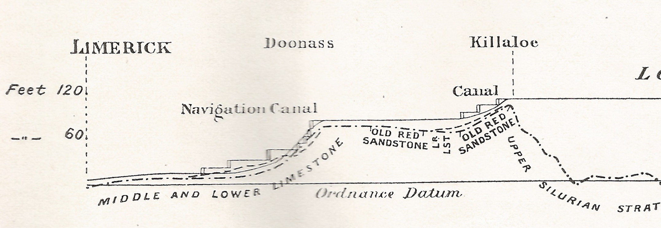
One of the Shannon books that are listed on the IWAI website but that I’d never seen is J B Cullen’s The River Shannon and its Shrines, which the IWAI list says is

Dublin. C.T.S. of Ireland. 1909. p.p.107. Green boards. Prof. illus.

IWAI also lists J E McKenna Lough Erne and its Shrines published by the Catholic Truth Society of Ireland in 1909, and it provides a link to a downloadable copy of what is a short work of 32 pages.

How many pages?

In 2004 that learnéd bibliophile Michael Slevin also provided a list of books being sold by Healy Rare Books, which included

J.B. Cullen. The River Shannon and its Shrines. Dublin. Browne & Nolan. n.d. Disbound. p.p.28. Illustrated.

I mention this because I have recently acquired a copy matching that description (though, I suspect, not at Healy prices). The number of pages is indeed 28 rather than the 107 mentioned on the IWAI listing. So were there two books with the same title by J B Cullen? My copy concludes with the words

At Killaloe may end the notice of the Upper Shannon and its Shrines.

That is followed by

[The Story of Saint Senanus, which is to follow, will introduce the remaining Sanctuaries of the hallowed and majestic River.]

It seems possible, therefore, that Cullen wrote more than one piece on the Shannon; perhaps they were originally published in the Catholic Truth Society magazine and then assembled to provide a 107-page book. The National Library suggests that there may have been four pieces.

I would be glad to hear from anyone who knows more about this — and to get copies of any other sections that may exist.

Athlone

Here is an extract from Cullen about Athlone.

To-day Athlone presents a picture of greater interest than many of our Irish cities or towns. Its normal population is some ten thousand inhabitants, but its importance as a military station often swells this aggregate. This latter circumstance gives a very distinct feature to Athlone. The town is generally bright and gay with the parade of military, and joyous with the strains of martial music, while ever and anon the practice of artillery keeps the echoes of the Shannon busy recalling — in our peaceful days — the stirring memories of the warring past.

The book was published in 1909: the army is that of His late Majesty King Edward VII.

Shannon -v- Erne

McKenna’s Erne book has a practical tone: it mentions the “finely-equipped paddle-steamer Lady of the Lake” but says

We prefer a modest little steam launch for the purpose of our present excursion.

Assuming we have a few quid to spare, of course. But Cullen says nothing about how the traveller is to get around. He has clearly been on the water (he visited several islands — and even Lough Forbes, which is not easy to see by road) but also travelled by land to Kilronan, Edgeworthstown and Roscommon. It would be interesting to know how and when he made his journeys.

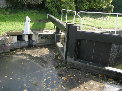
Despite its title, his book[let?] displays an interest in military as well as in religious sites and history, but there is nothing about contemporary waterways usage or traffic.

J B Cullen

From searching tinterweb, I conclude that John Bernard Cullen may have attended Mungret College in Limerick [PDF; mostly irrelevant] and had a brother called James who was a Jesuit, co-founded the Rosbercon Choir, lived at Bawnjames House near New Ross, was a founding committee member of the Catholic Truth Society of Ireland, contributed to the Parnell National Tribute and wrote lots of light historical articles. In 1886 two of his daughters, aged 3 and 13, drowned in an ornamental pond in his gardens.

I would welcome more information.

As far as I can tell he was dead before 1933 and his work is therefore out of copyright; accordingly I provide a PDF [5.3 MB] below.

The River Shannon and its Shrines

Wading in the water (not)

See the bottom of a lock (with no water in it). This is Carpenters Road Lock in London, which also featured here.

h/t CELR

Royal water

An interesting piece of information from Waterways Ireland’s feasibility study on the restoration of the Longford Branch of the Royal Canal. We learn on page 44 that the Royal Canal needs, on average, 10 million gallons of water per day to cope with “lockages, leakage, seepage and evaporation” and that the current supply arrangements, with much pumping, are costing €300,000 a year.


Sorry, Longford

Waterways Ireland’s Feasibility Study into the Restoration of the Longford Branch of the Royal Canal is available for download [7 PDFs: main report + 6 appendices]. Skip straight to page 59:

6.5 Recommendation

Given the current financial climate and because of the associated costs, environmental issues and uincertainty regarding planning approval it is not recommended to pursue this project any further at this time.

The recent work undertaken in regard to the shared walkway/cycleway has protected the asset as a publicly owned recreational amenity and it is recommended that any outstanding property issues be resolved and finalised in order to complete the protection of the asset.

I hope that admirable recommendation survives the pre-election period.

By the way, there’s a snail ….

Saunderson’s Sheugh

The Minister for  Arts, Heritage and the Gaeltacht [who is also a Fine Gael TD for Cavan–Monaghan] spoke at the meeeting of the Joint Oireachtas Committee on Environment, Culture and the Gaeltacht on 25 November 2014. She said:

In addition to progressing North-South co-operation, my key priority is progressing the first stage of the Ulster Canal project from upper Lough Erne to Castle Saunderson, near Belturbet, County Cavan. I am working on this with the Government and other key partners, including the North-South Ministerial Council and Waterways Ireland. […]

It sounds, then, as if the minister intends to get work started on the Clones Sheugh, but only as far as Castle Saunderson, where there is a scouting establishment. The route from Quivvy Lough (location of the Quivvy Marina) is along the Finn River; the first 5.5 km of the route would be in the river and the last 8.5 km to Clones in a canal. The route to Castle Saunderson would, I imagine, require dredging and the removal of rocks as well as work on [or replacement of] Derrykerrib Bridge [I have not read all the details].

It would, of course, be faster to get there by road, but no doubt lots of people will travel from Foreign Parts for the excitement of seeing Castle Saunderson from the water and paying tribute to the memory of a stout Orangeman and founder of the Irish Unionist Alliance.

No mention of the treasure-hunting group who are to find the money, but there’s an election in the offing so money won’t be a problem. Until afterwards.

Quivvy to Castle Saunderson [OSI ~1840]

Quivvy to Castle Saunderson [OSI ~1840]

The minister also said:

Regarding the Ulster Canal, which stretches from upper Lough Erne to Castle Saunderson, we hope to get the project started on that section because that is the one part of the inland waterway system that has not been developed. If we get that done, the Ulster Canal will connect into Lough Neagh. That means we will have a complete network of waterways in Ireland, which is very important. It is also a cross-Border project, and there is a peace dividend in terms of that project. It is very important in terms of cross-Border relationships. It is one shovel-ready project that can be progressed.

The minister said that “a complete network of waterways in Ireland […] is very important”. She did not say why and I can think of no possible economic justification for the creation of such a “network”. Nor is it clear what the “peace dividend” is. But the phrase that evoked most terror is “shovel-ready project”, which I take to mean something that might buy votes in the next election.

The minister’s predecessor, Éamon Ó Cuív, a Fianna Fáil TD for Galway West, said:

I welcome the Minister’s continuation of the work on the Ulster canals. There was quite a bit of work done on that in my time and I was very anxious to see it progress on a step-by-step basis. I was going to bring it to Clones, I am not sure whether the place the Minister mentioned is further or nearer than that.

The minister interjected:

It is not as far as Clones. We will start it anyway and we will get it there.

And Mr Ó Cuív continued:

I take the view that even if she were to get it half a mile, we should just nibble away at it until we get it finished. It is of strategic national importance and if we could connect Coleraine, where I was the other day and where my poor car is getting mended, all the way down the coast through Lough Neagh down to Shannon and back up the canals, it would be a fantastic facility for the island. I will not be heard complaining in any way that it is in the Minister’s constituency – that just happens to be a happy coincidence in this case.

Actually, although both Quivvy Marina and Castle Saunderson are in the Free State, most of the River Finn route is in the United Kingdom of Great Britain and Northern Ireland.

It seems that I must cease to speak of the Clones Sheugh: it’s Saunderson’s Sheugh. I suppose that, if reaching Castle Saunderson were enough to shut up the Shinners, who seem to be madly keen on Sheughery for some reason that is hidden from me, that might be a bargain: it would certainly be better than going all the way to Clones.

My OSI logo and permit number for website


Down to the sea in steps

On 28 January 1907 James Robinson Kilroe [near the bottom of the page] of H M Geological Survey read to the Royal Irish Academy a paper on “The River Shannon: its present course and geological history” [Proceedings of the Royal Irish Academy Vol XXVI Section B No 8 Hodges, Figgis & Co Ltd, Dublin; Williams & Norgate, London 1907]. I thought that Plate V was interesting.

Shannon Derg to sea

Plate V

Kilroe wrote:

It will be perceived that instead of the river being shallow over the unyielding Silurian slate-rock, set almost vertically, and striking across the river-course, it is deeper than over the limestone of Lough Derg, and much deeper than over the comparatively easily eroded Old Red Sandstone at Killaloe. The river-bed actually drops below the datum line above the town, while at the town it is 100 feet above datum.

Old Red Sandstone strata are here to be seen in the river-bank, and Silurian rocks in situ in its bed. A barrier is thus formed, partly of Silurian, and partly of Old Red Sandstone rocks, which without the artificial impounding weir would retain the waters of Lough Derg to a depth of some 104 feet opposite Derrycastle — two miles above Killaloe.

One might have expected to find a fairly level shallow bed from Killaloe northward, a sudden drop from slate-rock to the sandstone floor, and  a pronounced wide, well-formed valley in the limestone district southward to Limerick.

None of these elements exist; instead, we have the formidable barrier at Killaloe, naturally damming up a considerable depth of water in Lough Derg, and the river falling away southward by a series of rapids which correspond with drops in the canal, south of O’Briensbridge […], along an alternative course, possibly one used by a branch of the Shannon.

Here is an extract from the Plate V map, showing the steps of the (pre-Ardnacrusha) Limerick Navigation between Lough Derg and the sea.

Shannon Killaloe to Limerick

The steps of the canal (click to enlarge)

Upstream

Kilroe wrote of Lough Ree:

The waters of Lough Ree stood some 10 feet higher within recent times than they now do, as proved by evidence of solution, with under-cutting of limestone blocks, to be seen about five miles north-west of Athlone, close to the railway, in the townland of Cornaseer.

Under these conditions the lake must have been, perhaps, twice its width, and for a considerable period. Its ancient surface-level is clearly indicated by the caps of the mushroom-shaped blocks.

And of the Shannon between Lough Ree and Lough Derg:

The extreme flatness of the river between Athlone and Meelick is such that, consequent upon the completion of the Suck Drainage-works in 1892, it was found that the callows along the Shannon above the confluence of the Suck at Shannonbridge were much more liable to sudden and frequent floodings than they previously had been.

The more rapid discharge of the Suck waters into the Shannon, before ordinary extra water had time to pass away, had the effect of modifying the regimen of the main stream to an extent which resulted in an action at law [La Touche -v- The Suck Drainage Board].

I have found only one account of that case, in the Freeman’s Journal of 1 July 1893. The plaintiffs, Messrs Harrison and La Touche, owned land at Cappaleitrim, on the west bank of the Shannon above Shannonbridge. They said that the actions of the Suck Drainage Board had caused their lands to be flooded:

[…] that the defendants brought water from the Suck into the Shannon, containing a drainage of 40 miles, with such velocity and such volume that the Shannon was penned back, and that the back water caused the damage to the lands complained of.

[…] The jury disagreed and were discharged.

I don’t know whether the matter ever again came before a judge.

Euroloot

I see there’s a new scheme for Euroloot: a €300 billion investment fund to save the European economies. Actually it seems there is only €5 billion in real money and Constantin Gurdgiev is properly scathing. It will be interesting to see whether Ireland can make the Clones Sheugh fit within the criteria.

The Black Bridge at Plassey

I am repeating here a point I made in response to a comment on this page. I do so because the point is, I think, an important one: some readers don’t check the comments and might miss this.

I have an imperfect copy [with some lines missing] of an indenture made on 8 July 1949 between the Minister for Finance and Limerick County Council under which the Council leased from the Minister

… all that those parts of the lands of Garraun and Sreelane on which Plassey Bridge abuts on both banks of the River Shannon and the site and piles of said Plassey Bridge together with said Plassey Bridge […].

I am not a lawyer, so my interpretation may be misleading, but I think that there are two points of interest.

The first is that, under the indenture, the Council is obliged to “well and sufficiently repair cleanse maintain amend and keep the hereby demised premises”, which includes the bridge. The Council is also required to “use the said demised premises as a public highway”.

The second is that, if the Council fails to do so, the Minister, and his agents the Commissioners of Public Works in Ireland, are entitled (after giving due notice) “to enter upon the hereby demised premises and to execute and to do the necessary repairs and works and the Lessees [ie Limerick Councy Council] shall repay the expenses of such repairs to the Lessor on demand […]“.

As far as I can see, Limerick County Council is in breach of its agreement with the Minister for Finance, and that Minister is entitled to repair the bridge and charge the Council for the cost.

If only there were a Minister for Finance who had an interest in Limerick (or in bridges) ….

A little rain goes a long way

Here are some water level readings from Athlone Weir. I’ve taken them from the OPW’s very useful water levels site, where you can monitor levels from the comfort of your own armchair. [If only there were a gauge at Killaloe ….]

At Athlone, staff gauge zero is 35.360m above Poolbeg datum (from 18 Oct 2003). I chopped the bottoms off the first two graphs. The first one shows the level for 35 days to 30 September 2014; I presume that the level of Lough Ree was being reduced to enable it to hold some of the autumn’s rainfall.

Athlone Weir 20140930

Athlone Weir 35 days to 30 September 2014 (truncated)

Here’s the graph for the 35 days to 15 October 2014.

Athlone Weir 20141015

Athlone Weir 35 days to 15 October 2014 (truncated)

Then, in October, the level began to rise again. By 30 October, it was back to about 2.1 metres, roughly the starting point on the first of the graphs above.

Athlone Weir 20141030

Athlone Weir 35 days ro 30 October 2014

And since then it has continued to rise.

Athlone Weir 20141117

Athlone Weir 35 days to 17 November 2014

Met Éireann’s weather summary for October 2014 [PDF] has this chart:

Met Eireann weather Oct 2014

Met Éireann rainfall October 2014

It says:

Rainfall: wet conditions nearly everywhere

Monthly rainfall totals were above-average nearly everywhere with the exception of stations in coastal areas in the Northwest and West and in parts of the Midlands. Percentage of Long-Term Average (LTA) values ranged from 81% at Gurteen to 161% at Johnstown Castle, which recorded it wettest October since 2002.

Fermoy (Moore Park) reported 135% of its LTA with 153.6 mm and its wettest October in 10 years. The wettest days were mainly the 3rd, 5th and 28th, with the month’s highest daily rainfall reported on the 5th at Cork Airport with 38.6 mm, its wettest October day in five years. Mullingar reported its wettest October day in 12 years on the 28th with 26.4 mm. The number of wet days (days with 1 mm or more rainfall) ranged from 12 at Casement Aerodrome to 24 at Valentia Observatory and Claremorris, with Claremorris reporting its highest number of October wet days since 1973.

Use of the OPW charts is licensed under Directive 2003/98/EC [PDF] of the European Parliament and of the Council on the re-use of public sector information. Met Éireann allows use of “the web pages, and the information contained within them, for private and non-commercial purposes, for teaching, and for research […] is allowed subject to the condition that the source of the information is always credited in connection with its use”.


Airholes on the Kennet & Avon Canal

John Ditchfield very kindly photographed some airholes on the Kennet & Avon Canal and sent on the photos. The captions are his comments.

Bath05_resize

Good length of overflow. Water flowing.

Bath07_resize

No overflow.

Bath06_resize

(Rebuilt) small openings are above the level of the top of the adjacent lock gate. However, just upstream there is another paddle or sluice gate on the canal side (next photo), so perhaps that is used to control the level.

Bath08_resize

The upstream paddle or sluice gate.

Bath09_resize

Overflow in action, preventing water overflowing gates.

Note: this lock connects the canal with the River Avon, and the building in the background was a steam pumping station, presumably for topping up the canal from the river.

Many thanks to John for taking the trouble.