Tag Archives: Suck

The Hind

The River Hind Navigation is not well known, which may be attributable to its non-existence. There were several proposals to make the Hind navigable, to link the town of Roscommon to Lough Ree on the Shannon, but none of them were implemented. One of them almost made it, though, and such interest as the topic has is the result of the Hind’s inclusion (or semi-inclusion) on the list of navigations for which W T Mulvany, Commissioner for Drainage, was responsible in the late 1840s and early 1850s.

Mulvany was responsible for five drainage-cum-navigation projects (and many drainage projects), whereof the Hind was the least important. The other four were

  • the Lough Oughter navigation, upstream on Lough Erne from Belturbet, which was never completed: various (mostly Fianna Fáil) insane politicians in the area are still trying to have it completed
  • the Cong and Belturbet Canals, which were abandoned before they were finished
  • the Junction Canal in the Ballinamore and Ballyconnell Drainage District, later known as the Ballinamore and Ballyconnell Canal, which had a brief and notoriously unprofitable existence, but which was later transformed into the Shannon—Erne Waterway, which was a good investment for Ireland because the Germans [or someone] paid for it
  • the Lower Bann navigation, linking Lough Neagh (which already had two links to coastal ports) with the North Atlantic in the middle of a beach near Coleraine. This was the only one of Mulvany’s navigations that was completed and that remained open, despite its complete uselessness, as the railways got to the area before the navigation did.

In this catalogue of commercial nitwittedness, the Hind had the advantage that it was delayed: an even more insane proposal, to drain the Suck into the Hind, meant that the Hind navigation scheme was deferred long enough to be abandoned altogether, which was just as well as the railway soon made any navigation unnecessary.

However, the proposal was there and, if you are very bored, you might like to read about it. But this is for anoraks: the subject is unimportant, the detail [163 endnotes] outweighing what little interest the scheme possesses. There are no photos of boats or of locks, because there weren’t any; there aren’t even any cat videos.


Pollboy Lock

I mentioned some time ago that, according to its Business Plan 2015, Waterways Ireland was considering automating Pollboy Lock, on the River Suck to Ballinasloe, in order to save costs. Like other offshoots from the main Shannon Navigation [Killaloe to Lough Key], the Suck is relatively little used.

According to the Connacht Tribune, the automation is to proceed and the lockkeeper is to be reassigned. It seems that some local councillors and “business interests” — who do not, as far as I know, contribute to Waterways Ireland’s income — regret the loss of an ambassador for the town. The keeper, Mr Coyne, was indeed extremely helpful to visiting boaters.

However, he could help only those who arrived at his lock: he could do nothing to attract more boating visitors to the town. That is not in the least a criticism of him, but rather a suggestion that councillors and business interests might perhaps have done, or yet do, more to attract visitors and increase the usage of the splendid harbour in Ballinasloe. Perhaps they might even appoint and pay a town ambassador?

A Sinn Féin councillor quoted in the article seems not to be entirely familliar with the duties of lockkeepers. Furthermore, he does not take account of the fact that the Shannon–Erne Waterway succeeds without lockkeepers — or that it was proposed that the Clones Sheugh [not-the-Ulster-Canal] operate in the same way. Surely a Sinn Féin councillor is not suggesting that, without keepers, the Sheugh might not be the enormous success that his party purports to believe it would be?

PS: the Tribune also has a piece about rubbish at Castle Harbour, Portumna.


Shannon–Erne Waterway traffic

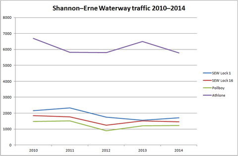
I have reported regularly on Shannon traffic figures [most recently here] but I have paid relatively little attention to the Shannon–Erne Waterway [SEW]. I am therefore grateful to Waterways Ireland for supplying me with the last five years’ monthly traffic figures for Locks 1 and 16 on the SEW. I had some queries about the figures for certain months and I have put them to Waterways Ireland, but I presume that the annual figures are OK.

Shannon–Erne Waterway traffic 2010–2014

Shannon–Erne Waterway traffic 2010–2014

Clearly, not all boats go all the way through: if they did, the figures for Locks 1 and 16 might be the same. The hire bases for Locaboat, Riversdale and Corraquill were all on the Erne side of the summit level; does Lock 1’s excess of traffic over Lock 16 suggest that hirers, perhaps wishing to minimise the number of locks they passed through, headed for the Erne rather than the Shannon? The figures, which I presume are gathered automatically, do not distinguish between private and hired boats.

The other point that strikes me is that the level of traffic is actually quite low. I put in the figures for Pollboy and Athlone locks to allow comparison. SEW traffic is greater than that on the Lough Allen Canal, but it is not much greater than that on the River Suck to Ballinasloe. In that case, WI is [according to its Business Plan 2015] considering automating Pollboy Lock to reduce costs.

Pollboy lock passages 2005–2014

Pollboy lock passages 2005–2014

The SEW locks are already automated, but the costs and benefits may have to be re-examined, especially now that Locaboat has moved from Ballinamore to Quigleys Marina at Killinure on Lough Ree: I presume that that will result in less traffic on the SEW.

Pollboy and the CLones Sheugh

In 2006 Pollboy traffic was used as the basis for estimating likely traffic to Clones on the Ulster Canal’s “SW section”:

The total number of boat parties/groups for the SW section is assumed to be 600. This is based on a comparison with another “offshoot” like the Suck Navigation which had around 1,250 boat parties/groups in 2005 (obtained by dividing the passages through Pollboy Lock by 2) in a much busier section of the whole system. So, for the SW section, a level of around 50% (ie. 600) is regarded as a reasonable assumption.

Waterways Ireland Socio economic Summary Report for the NE and SW Sections of the Ulster Canal Final Report February 2006

Now that Pollboy’s traffic is half what it was in 2005, no doubt the estimate for the number of boats that would visit Clones, if a canal ever reached it, has likewise been halved, which would give an average of about ten boats a week over a seven-month season: four boats every Saturday and one a day for the rest of the week. Folk intending to build restaurants to cater for the cruiser traffic might be wise to reassess their investment plans:

In overall terms, the benefits of waterway restoration derive from the fact that these can facilitate a variety of leisure and recreational activity, that the users will benefit from this activity, and that there will also be wider spin-off benefits in the areas, e.g. facilities such as restaurants etc built to service canal traffic.

Department of Arts, Heritage and the Gaeltacht Restoring the Ulster Canal from Lough Erne to Clones Updated Business Case February 2015

There’s not enough business there for a burger van, never mind a restaurant.

The magic of the Shannon–Erne Waterway

But if Pollboy, the River Suck and Ballinasloe are no longer cited as support for the construction of a Clones Sheugh, the Shannon–Erne Waterway is still used as an example, in that and in other contexts. Take, for example, this:

Shannon–Erne Waterway magic

Shannon–Erne Waterway magic

I’ve nicked that from a slide show called Economic, Recreational and Social Benefits of Rural Waterways in Ireland, which was to be delivered [PDF] by Garret McGrath of Waterways Ireland at the World Canals Conference [PDF] in Milan in 2014.

Now, if the Shannon–Erne Waterway had caused all that construction activity, we’d have to drag Waterways Ireland before the Irish banking enquiry. Skipping lightly over the question of the ghost estates, and the departure of Locaboat from Ballinamore, we come to the real problem with this sort of stuff: the post hoc fallacy. We are invited to believe that

  • a waterway was built
  • prosperity followed
  • so the waterway must have caused the prosperity.

Well, maybe it did and maybe it didn’t, but the argument presented in the slide show isn’t sufficient to prove it. You would have to check to see whether there were any other possible explanations: any other changes that might have resulted in all that construction.

Along the Shannon–Erne Waterway, I can think of two other possible factors: Sean Quinn’s business empire and the Upper Shannon Rural Renewal Scheme, a tax dodge that applied in Leitrim, Longford, Roscommon, Cavan and Sligo, five of the six counties that had the highest rates of vacant housing (excluding holiday houses). So there are two problems here:

  • much of that construction activity may have been driven by tax breaks rather than by the existence of a nearby waterway
  • the construction itself may not have had beneficial effects.

You can read more about that here, noting in particular, on the map, the areas around the upper Shannon and the SEW with vacancy rates of over 25%; you might wonder whether Waterways Ireland is wise to claim credit for housing over-development.

But my main concern here is a different one: that, if you want to claim credit for economic benefits that followed waterways development, you have to measure the benefits and subtract those attributable to other factors, such as Sean Quinn and the Rural Renewal Scheme. Then it would be useful if you compared the remaining benefits with the cost of constructing your waterway: it might then be possible to say that waterways development is a good investment.

It may be that such a study has been done on the SEW, but if it has I don’t know where it is; I would like to see it if it exists. Until then, I regard this sort of thing, from DAHG’s Business Case, as drivel:

The broad existence and nature of the potential socio-economic benefits of canals and restored waterways are therefore well established and not really at issue.

Sorry, minister: that’s rubbish. As far as I know no proper evaluation has ever been carried out on the costs and benefits of any restored or new-built Irish waterway. So you’re not getting away with that one.


Down to the sea in steps

On 28 January 1907 James Robinson Kilroe [near the bottom of the page] of H M Geological Survey read to the Royal Irish Academy a paper on “The River Shannon: its present course and geological history” [Proceedings of the Royal Irish Academy Vol XXVI Section B No 8 Hodges, Figgis & Co Ltd, Dublin; Williams & Norgate, London 1907]. I thought that Plate V was interesting.

Shannon Derg to sea

Plate V

Kilroe wrote:

It will be perceived that instead of the river being shallow over the unyielding Silurian slate-rock, set almost vertically, and striking across the river-course, it is deeper than over the limestone of Lough Derg, and much deeper than over the comparatively easily eroded Old Red Sandstone at Killaloe. The river-bed actually drops below the datum line above the town, while at the town it is 100 feet above datum.

Old Red Sandstone strata are here to be seen in the river-bank, and Silurian rocks in situ in its bed. A barrier is thus formed, partly of Silurian, and partly of Old Red Sandstone rocks, which without the artificial impounding weir would retain the waters of Lough Derg to a depth of some 104 feet opposite Derrycastle — two miles above Killaloe.

One might have expected to find a fairly level shallow bed from Killaloe northward, a sudden drop from slate-rock to the sandstone floor, and  a pronounced wide, well-formed valley in the limestone district southward to Limerick.

None of these elements exist; instead, we have the formidable barrier at Killaloe, naturally damming up a considerable depth of water in Lough Derg, and the river falling away southward by a series of rapids which correspond with drops in the canal, south of O’Briensbridge […], along an alternative course, possibly one used by a branch of the Shannon.

Here is an extract from the Plate V map, showing the steps of the (pre-Ardnacrusha) Limerick Navigation between Lough Derg and the sea.

Shannon Killaloe to Limerick

The steps of the canal (click to enlarge)

Upstream

Kilroe wrote of Lough Ree:

The waters of Lough Ree stood some 10 feet higher within recent times than they now do, as proved by evidence of solution, with under-cutting of limestone blocks, to be seen about five miles north-west of Athlone, close to the railway, in the townland of Cornaseer.

Under these conditions the lake must have been, perhaps, twice its width, and for a considerable period. Its ancient surface-level is clearly indicated by the caps of the mushroom-shaped blocks.

And of the Shannon between Lough Ree and Lough Derg:

The extreme flatness of the river between Athlone and Meelick is such that, consequent upon the completion of the Suck Drainage-works in 1892, it was found that the callows along the Shannon above the confluence of the Suck at Shannonbridge were much more liable to sudden and frequent floodings than they previously had been.

The more rapid discharge of the Suck waters into the Shannon, before ordinary extra water had time to pass away, had the effect of modifying the regimen of the main stream to an extent which resulted in an action at law [La Touche -v- The Suck Drainage Board].

I have found only one account of that case, in the Freeman’s Journal of 1 July 1893. The plaintiffs, Messrs Harrison and La Touche, owned land at Cappaleitrim, on the west bank of the Shannon above Shannonbridge. They said that the actions of the Suck Drainage Board had caused their lands to be flooded:

[…] that the defendants brought water from the Suck into the Shannon, containing a drainage of 40 miles, with such velocity and such volume that the Shannon was penned back, and that the back water caused the damage to the lands complained of.

[…] The jury disagreed and were discharged.

I don’t know whether the matter ever again came before a judge.

Shannon traffic figures to July 2014

I am grateful to Waterways Ireland for letting me have the Shannon traffic figures for July 2014. All the usual caveats apply:

  • the underlying figures do not record total waterways usage (even for the Shannon) as, for instance, sailing, fishing or waterskiing on lakes or river stretches, which did not involve a passage through a lock or Portumna Bridge, would not be recorded
  • the passage records would not show, for instance, a change in the balance of types of activities from those in larger cruising boats to those in smaller (sailing, fishing, waterskiing) boats
  • figures like these, for a small number of months, will not necessarily be representative of those for the year as a whole. The winter months, January to March, see little traffic in any year; for April, May and June, the weather can have a large influence on the amount of activity especially, I suspect, in private boats.

On the other hand, the figures do include the Shannon’s most significant tourism activity, the cruiser hire business. And they are our only consistent long-term indicator of usage of the inland waterways.

Shannon all boats Jan to Jul 2014

Total (private + hired) traffic for the first seven months of each year

Traffic in 2013 was up a bit on 2012; 2014 is down slightly below the 2012 level. It’s the lowest seven-month figure in the series (ie since 2003), which is a bit of a surprise: I thought that the good weather would encourage more boating.

The changes are small, so their importance must not be exaggerated, but they’re not cause for celebration. Let’s see whether the drop was amongst private or hired boats (or both).

Shannon private boats Jan to Jul 2014

Private-boat traffic for the first seven months of each year

Private traffic is up a bit on 2012 but down on 2013.

Shannon hired boats Jan to Jul 2014

Hire-boat traffic for the first seven months of each year

Hire-boat traffic is down on both previous years, but the pace of decline seems to have slowed.

Shannon private and hired -v- 2003 Jan to Jul 2014

Changes since 2003: private and hired boats

Hire-boat traffic seems to be levelling off at 40% of its 2003 figure: a massive loss of business. I do not know whether anyone is trying to, or could, recover that amount of business. I am not aware of any new Shannon-based tourism business that could compensate for the losses in the cruising (hire-boat) business, but I would be glad to hear from anyone who knows of such projects. Something with high growth potential is required.

Private traffic is wobbling either side of its 2003 figure: the increases during the Celtic Tiger years have been lost.

Shannon private -v- hired boats Jan to Jul 2014

Still roughly 50/50

In the year to July 2014, hire-boat traffic was just above private traffic, but there is very little in it. Private traffic is now comparatively more important to Waterways Ireland [which may be why it is now trying to establish its economic importance] but it does not bring in much money from outside the two jurisdictions, so the case for public spending on waterways becomes much weaker.

And, quite clearly, opening more waterways doesn’t work: as this chart showed last month, the branches off the main lines of the Shannon, Erne and SEW are little used. The Lough Allen Canal, the Suck and the navigation to Limerick are very little used and I see no sign that the reopened Royal Canal has attracted many visitors to Ireland. What is needed is more intensive usage of the main waterways, not further dilution by the opening of more branches [to Clones or anywhere else].

SnnNav JanJun 6

High and low usage

Finally, I thought it might be interesting to see whether the monthly pattern of usage has changed since 2003. To avoid an over-cluttered chart, I included only four years: 2003, 2003 +5, 2003 + 10 and 2014. The chart is for all boats, private and hired.

Shannon all boats by month selected years Jan to Jul 2014

Monthly traffic, selected years

The season seems to have got going earlier in 2003 and even in 2008. Was the weather better in those years?


Did you know …

… that Pollboy Lock, on the River Suck, can be filled in one minute and fifty-eight seconds?

Pollboy

Pollboy

Ballinasloe footbridge

Here is a new page with a brief account of the Ballinasloe Line of the Grand Canal and some photos of a footbridge that seems to have been built across it in the twentieth century.

The Shannonbridge chimneys

The chimneys of the power station at Shannonbridge, on the river Shannon between Lough Ree to the north and Lough Derg to the south, have for many years been a landmark: visible from a long way away in both directions on the Shannon and on its tributary the Suck as well. They were demolished last week. I have put up a page of photographs as a reminder of what they looked like and to mark their passing.