See the bottom of a lock (with no water in it). This is Carpenters Road Lock in London, which also featured here.
h/t CELR
See the bottom of a lock (with no water in it). This is Carpenters Road Lock in London, which also featured here.
h/t CELR
Posted in Built heritage, Canals, Economic activities, Engineering and construction, Extant waterways, Foreign parts, Industrial heritage, Operations, Restoration and rebuilding, waterways, Waterways management
Tagged canal, canal & river trust, Carpenters Road Lock, gates, lock, Operations, sill, stop-planks
An interesting piece of information from Waterways Ireland’s feasibility study on the restoration of the Longford Branch of the Royal Canal. We learn on page 44 that the Royal Canal needs, on average, 10 million gallons of water per day to cope with “lockages, leakage, seepage and evaporation” and that the current supply arrangements, with much pumping, are costing €300,000 a year.
Posted in Ashore, Built heritage, Canals, Drainage, Economic activities, Engineering and construction, Extant waterways, Industrial heritage, Ireland, Operations, Restoration and rebuilding, Sources, waterways, Waterways management, Weather
Tagged evaporation, gallons, Ireland, leakage, lockage, Operations, pump, pumping, Royal Canal, seepage, water level, water supply, Waterways Ireland
The Minister for Arts, Heritage and the Gaeltacht [who is also a Fine Gael TD for Cavan–Monaghan] spoke at the meeeting of the Joint Oireachtas Committee on Environment, Culture and the Gaeltacht on 25 November 2014. She said:
In addition to progressing North-South co-operation, my key priority is progressing the first stage of the Ulster Canal project from upper Lough Erne to Castle Saunderson, near Belturbet, County Cavan. I am working on this with the Government and other key partners, including the North-South Ministerial Council and Waterways Ireland. […]
It sounds, then, as if the minister intends to get work started on the Clones Sheugh, but only as far as Castle Saunderson, where there is a scouting establishment. The route from Quivvy Lough (location of the Quivvy Marina) is along the Finn River; the first 5.5 km of the route would be in the river and the last 8.5 km to Clones in a canal. The route to Castle Saunderson would, I imagine, require dredging and the removal of rocks as well as work on [or replacement of] Derrykerrib Bridge [I have not read all the details].
It would, of course, be faster to get there by road, but no doubt lots of people will travel from Foreign Parts for the excitement of seeing Castle Saunderson from the water and paying tribute to the memory of a stout Orangeman and founder of the Irish Unionist Alliance.
No mention of the treasure-hunting group who are to find the money, but there’s an election in the offing so money won’t be a problem. Until afterwards.
![Quivvy to Castle Saunderson [OSI ~1840]](https://irishwaterwayshistory.com/wp-content/uploads/2014/12/quivvy-to-castle-saunderson_resize.jpg)
Quivvy to Castle Saunderson [OSI ~1840]
Regarding the Ulster Canal, which stretches from upper Lough Erne to Castle Saunderson, we hope to get the project started on that section because that is the one part of the inland waterway system that has not been developed. If we get that done, the Ulster Canal will connect into Lough Neagh. That means we will have a complete network of waterways in Ireland, which is very important. It is also a cross-Border project, and there is a peace dividend in terms of that project. It is very important in terms of cross-Border relationships. It is one shovel-ready project that can be progressed.
The minister said that “a complete network of waterways in Ireland […] is very important”. She did not say why and I can think of no possible economic justification for the creation of such a “network”. Nor is it clear what the “peace dividend” is. But the phrase that evoked most terror is “shovel-ready project”, which I take to mean something that might buy votes in the next election.
The minister’s predecessor, Éamon Ó Cuív, a Fianna Fáil TD for Galway West, said:
I welcome the Minister’s continuation of the work on the Ulster canals. There was quite a bit of work done on that in my time and I was very anxious to see it progress on a step-by-step basis. I was going to bring it to Clones, I am not sure whether the place the Minister mentioned is further or nearer than that.
The minister interjected:
It is not as far as Clones. We will start it anyway and we will get it there.
And Mr Ó Cuív continued:
I take the view that even if she were to get it half a mile, we should just nibble away at it until we get it finished. It is of strategic national importance and if we could connect Coleraine, where I was the other day and where my poor car is getting mended, all the way down the coast through Lough Neagh down to Shannon and back up the canals, it would be a fantastic facility for the island. I will not be heard complaining in any way that it is in the Minister’s constituency – that just happens to be a happy coincidence in this case.
Actually, although both Quivvy Marina and Castle Saunderson are in the Free State, most of the River Finn route is in the United Kingdom of Great Britain and Northern Ireland.
It seems that I must cease to speak of the Clones Sheugh: it’s Saunderson’s Sheugh. I suppose that, if reaching Castle Saunderson were enough to shut up the Shinners, who seem to be madly keen on Sheughery for some reason that is hidden from me, that might be a bargain: it would certainly be better than going all the way to Clones.
![]()
Posted in Ashore, Built heritage, Canals, Economic activities, Engineering and construction, Extant waterways, Foreign parts, Forgotten navigations, Industrial heritage, Ireland, Natural heritage, Non-waterway, Operations, People, Politics, Restoration and rebuilding, Sources, Tourism, Ulster Canal, Uncategorized, Water sports activities, waterways, Waterways management
Tagged Belturbet, boats, bridge, canal, Castle Saunderson, Clones, department of arts heritage and the gaeltacht, Derrykerrib, Erne, flow, Ireland, lock, lost, Lough Neagh, Operations, Quivvy, River Finn, Shannon-Erne Waterway, Wattle Bridge, workboat
On 28 January 1907 James Robinson Kilroe [near the bottom of the page] of H M Geological Survey read to the Royal Irish Academy a paper on “The River Shannon: its present course and geological history” [Proceedings of the Royal Irish Academy Vol XXVI Section B No 8 Hodges, Figgis & Co Ltd, Dublin; Williams & Norgate, London 1907]. I thought that Plate V was interesting.
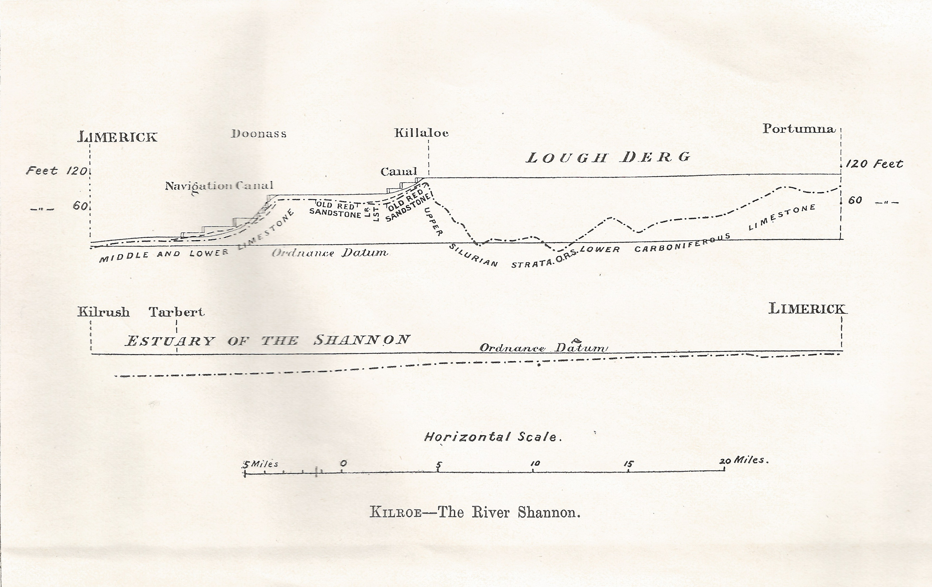
Plate V
Kilroe wrote:
It will be perceived that instead of the river being shallow over the unyielding Silurian slate-rock, set almost vertically, and striking across the river-course, it is deeper than over the limestone of Lough Derg, and much deeper than over the comparatively easily eroded Old Red Sandstone at Killaloe. The river-bed actually drops below the datum line above the town, while at the town it is 100 feet above datum.
Old Red Sandstone strata are here to be seen in the river-bank, and Silurian rocks in situ in its bed. A barrier is thus formed, partly of Silurian, and partly of Old Red Sandstone rocks, which without the artificial impounding weir would retain the waters of Lough Derg to a depth of some 104 feet opposite Derrycastle — two miles above Killaloe.
One might have expected to find a fairly level shallow bed from Killaloe northward, a sudden drop from slate-rock to the sandstone floor, and a pronounced wide, well-formed valley in the limestone district southward to Limerick.
None of these elements exist; instead, we have the formidable barrier at Killaloe, naturally damming up a considerable depth of water in Lough Derg, and the river falling away southward by a series of rapids which correspond with drops in the canal, south of O’Briensbridge […], along an alternative course, possibly one used by a branch of the Shannon.
Here is an extract from the Plate V map, showing the steps of the (pre-Ardnacrusha) Limerick Navigation between Lough Derg and the sea.
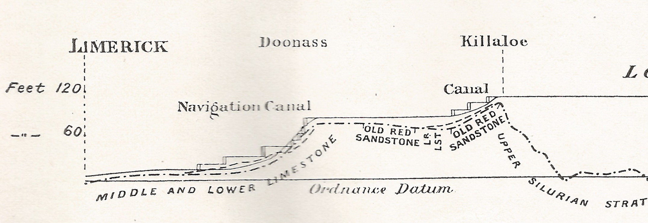
The steps of the canal (click to enlarge)
Kilroe wrote of Lough Ree:
The waters of Lough Ree stood some 10 feet higher within recent times than they now do, as proved by evidence of solution, with under-cutting of limestone blocks, to be seen about five miles north-west of Athlone, close to the railway, in the townland of Cornaseer.
Under these conditions the lake must have been, perhaps, twice its width, and for a considerable period. Its ancient surface-level is clearly indicated by the caps of the mushroom-shaped blocks.
And of the Shannon between Lough Ree and Lough Derg:
The extreme flatness of the river between Athlone and Meelick is such that, consequent upon the completion of the Suck Drainage-works in 1892, it was found that the callows along the Shannon above the confluence of the Suck at Shannonbridge were much more liable to sudden and frequent floodings than they previously had been.
The more rapid discharge of the Suck waters into the Shannon, before ordinary extra water had time to pass away, had the effect of modifying the regimen of the main stream to an extent which resulted in an action at law [La Touche -v- The Suck Drainage Board].
I have found only one account of that case, in the Freeman’s Journal of 1 July 1893. The plaintiffs, Messrs Harrison and La Touche, owned land at Cappaleitrim, on the west bank of the Shannon above Shannonbridge. They said that the actions of the Suck Drainage Board had caused their lands to be flooded:
[…] that the defendants brought water from the Suck into the Shannon, containing a drainage of 40 miles, with such velocity and such volume that the Shannon was penned back, and that the back water caused the damage to the lands complained of.
[…] The jury disagreed and were discharged.
I don’t know whether the matter ever again came before a judge.
Posted in Ashore, Built heritage, Canals, Drainage, Economic activities, Engineering and construction, Extant waterways, Industrial heritage, Ireland, Irish waterways general, Natural heritage, Operations, People, Safety, Shannon, Sources, The cattle trade, waterways, Waterways management, Weather
Tagged bridge, canal, Cappaleitrim, Cornaseer, Doonass, drainage, estuary, floods, flow, Ireland, Killaloe, Kilroe, Limerick, lock, Lough Derg, Lough Ree, O'Briensbridge, Operations, RIA, Shannon, Shannonbridge, Suck, water level, waterways
There is to be a maritime history conference in Cork next weekend:
Maritime History Conference to take place in University College Cork 28/29 November
Maritime History Conference‘A safe place for ships’: Cork, Ireland, Europe and the Sea
University College CorkFriday, 28 November – Saturday, 29 November
Main Campus: Electrical Engineering BLDG, L-1, UCC
Details here; h/t AD.
It appears that these new-fangled railways are here to stay, displacing the passage-boat and the mail-coach, the Scotch cart and the lumber boat.
Accordingly, I have rearranged my small number of railway-related pages under a top-level heading of their own.
I have added a new railway page, about the Lundy Island Railway and Colonization Company, from the Dublin Evening Mail of 2 May 1845. Gerald M King has produced stamps for Lundy, including Railway Parcel Stamps, but it is not clear whether they depict any of the engines or rolling stock described in the Mail and there are few other sources of information about the railway.
I have tried to explain as many of the references as I could, but some are still obscure to me and I would welcome comments from those expert in Irish religious conflicts of the 1840s (as well as those knowledgeable about railways and other technology of the period).
Amongst the objects of iron found during the Shannon Navigation Works, 1843–48, and presented by the Shannon Commissioners to the Academy, an iron sword (figure 1) is of much interest. It is of the Halstatt class, and is, I believe, the only iron example of that class which has been found in Ireland.
A label attached to the sword states that it was “taken up in the buckets of the ‘C’ dredger” out of the bed of the Shannon above the new bridge of Athlone, August, 1847.
It is incomplete, and has lost much of its substance from rust, especially along the edges. The form, however, can be distinguished. It is made on the pattern of the leaf-shaped bronze sword. The width of the blade increases towards the point, and the handle-plate was of the flat form of the bronze swords.
![Fig 1 Iron sword found in the Shannon [rotated]](https://irishwaterwayshistory.com/wp-content/uploads/2014/11/iron-sword-found-by-snncommnrs-george-coffey_resize.jpg)
Fig 1 Iron sword found in the Shannon [rotated]. Top end to right-hand side
This latter feature is certain, and is the most definite in the specimen. The edge of the handle-plate is intact for a short length at the right side; and the remains of a rivet-hole can be seen on the expanded portion at the hilt.
The curve in the blade does not appear to be intentional, but to be due to a bend it has received about one-third up; the line of the ridge is straight to and beyond the bend. This ridge along the centre of the blade is not a very usual feature; but it occurs occasionally on the bronze swords, and on an iron Halstatt sword found in Poitou, figured by the Abbé H Breuil (Revue Archéologique 1903 II p57).
This latter sword was found at Mignaloux-Beauvoir, near Poitiers, in 1836, but had remained unnoticed in the Museum at Poitiers until the paper mentioned. It measures in its present state 45 cm. The Irish fragment is 18½ inches long (47 cm); so the two swords were much of the same length.
A fairly large number of the bronze swords of the Halstatt type have been found in Ireland. There are twenty in the collection, and six of the winged chaps or scabbard ends of that period.
The occurrence in Ireland of the type in iron is therefore of considerable interest. The somewhat slender look of the sword and the ridge disposes me to regard it as late in the series; it must, however, rank as probably the earliest type of the iron sword which has been found in this country.
The early iron sword with flat handle-plate had been found in considerable numbers east and south of Poitou in Berry, Bourgogne, and in Lot. But its extension to the west had not been known till the example figured by the Abbé Breuil. It should be noted that Poitiers is close to the old line of communication between Ireland and the Continent by way of the Loire valley.
Illness has prevented me from placing before the Academy the archaeological evidence I have collected bearing on the question of early intercourse between Gaul and Ireland; but I should like to state as a preliminary note, that certain forms of bronze caldrons and types of pottery at the close of the Bronze Age, also of types of iron spear-heads and other objects of the La Tene period, may be advanced in support of the historical tradition in our tales of a settlement of Gauls in Leinster under Labraidh Loinngsech, at a date placed perhaps too early by the Four Masters (BC 541), and from whose “broad blue spears” the name of the province of Leinster (Laighen) is derived.
George Coffey “Early iron sword found in Ireland” Proceedings of the Royal Irish Academy Vol XXVI Section C No 3 February 1906 Hodges, Figgis & Co Ltd, Dublin; Williams & Norgate, London
Posted in Economic activities, Engineering and construction, Extant waterways, Foreign parts, Industrial heritage, Ireland, Irish inland waterways vessels, Operations, Restoration and rebuilding, Shannon, Sources, waterways
Tagged Athlone, bridge, Commissioners, dredger, Operations, Shannon, Shannon Navigation, sword, vessels, waterways

