
-

Waterways and Means by Brian J Goggin available now -
Join 584 other subscribers
RSS links
Pages
- Waterways & past uses
- Saving the nation
- Turf and bog navigations
- The Bog of Allen from the Grand Canal in 1835
- John’s Canal, Castleconnell
- The Canal at the World’s End
- The Finnery River navigation
- The Lough Boora Feeder
- The Little Brosna
- The Lullymore canal as wasn’t
- The Roscrea canals
- The Monivea navigations
- Lacy’s Canal
- The Rockville Navigation page 1
- The Rockville Navigation page 2
- The Rockville Navigation page 3
- Rockingham
- The Colthurst canals
- The Inny navigation
- The lower Shannon
- The piers, quays and harbours of the Shannon Estuary
- Nimmo’s non-existent harbour
- The Doonbeg Ship Canal
- Querrin
- Kilrush and its sector lock
- The Killimer to Tarbert ferry
- The Colleen Bawn at Killimer
- Knock knock. Who’s there?
- Cahircon: not at all boring
- Ringmoylan
- The hidden quay of Latoon
- The stones of Kilteery
- The Maigue
- Sitting on the dock of the Beagh
- Massy’s Quay, Askeaton and the River Deel
- Saleen Pier
- The Lord Lieutenant’s Visit to Limerick — trip down the Shannon [1856]
- The Fergus
- The Limerick Navigation
- The boundaries of the Shannon
- The power of the Shannon
- The locks on the Limerick Navigation
- Plassey
- Worldsend, Castleconnell, Co Limerick
- The bridge at O’Briensbridge
- The Limerick Navigation and the Monmouthshire Canal
- The Limerick Navigation (upper end) in flood November 2009
- The Limerick Navigation (lower end) in flood November 2009
- The Limerick Navigation (tidal section) in flood November 2009
- Floods in Limerick (1850)
- Limerick to Athlone
- The piers, quays and harbours of the Shannon Estuary
- The middle and upper Shannon
- The Grand Canal
- Monasterevan, the Venice of the west
- The Grand Canal lottery
- Grand Canal carrying: some notes
- The dry dock at Sallins
- The Naas Branch
- The Mountmellick Line of the Grand Canal
- Dublin to Ballinasloe by canal
- The Ballinasloe Line
- A Grand Canal lock: Belmont
- South of Moscow, north of Geneva
- Water supply to the Grand Canal
- The Grand Canal Company strike of 1890
- The Royal Canal
- Water supply to the Royal Canal: the feeders
- The Lough Owel feeder
- The proposed Lough Ennell water supply to the Royal Canal
- From Clonsilla to Clew Bay
- Kinnegad and the Royal Canal
- The sinking of the Longford in 1845
- Steamers on the Royal Canal
- Leech of Killucan: horse-drawn boats on the Royal
- Horses on board
- Royal eggs
- Prothero on the Royal
- The whore who held the mortgage on the Royal Canal
- Waterways in Dublin
- The Naller
- Visit Dublin. Walk canals. Drink beer.
- The Broadstone Line of the Royal Canal
- Effin Bridge: its predecessors
- Between the waters
- The abandoned Main Line of the Grand Canal 1
- The abandoned Main Line of the Grand Canal 2
- The abandoned Main Line of the Grand Canal 3
- The abandoned Main Line of the Grand Canal 4
- Waterways of the south-east
- Waterways of Cork and Kerry
- Waterways of the west
- Waterways of Ulster and thereabouts
- People
- Systems & artefacts
- Irish waterways furniture
- Irish waterways operations
- Miscellaneous articles
- Irish inland waterways vessels
- Cots -v- barges: defining Irish waterways
- Waterways Ireland workboats
- Wooden boats on Irish inland waterways
- Traditional boats and replicas
- Non-WI workboats
- Older Irish working boats
- The barge at Plassey
- Dublin, Athlone and Limerick
- Waterford to New Ross by steam
- The steamer Cupid
- Liffey barges 1832
- Steam on the Grand Canal
- The Mystery of the Sunken Barge
- Steam on the Newry Canal
- Guinness Liffey barges 1902
- Up and under: PS Garryowen in 1840
- Watson’s Double Canal Boat
- The Cammoge ferry-boat
- The ’98 barge
- Late C19 Grand Canal Company trade boats
- Chain haulage
- Ballymurtagh
- The Aaron Manby and the Shannon
- A sunken boat in the Shannon
- Sailing boats on Irish inland waterways
- Some boats that are … different
- Square sail
- 4B mooring
- Irish waterways scenery
- Engineering and construction
- Irish navigation authorities
- Opinion
- The folly of restoration
- The Ulster Canal now
- The Ulster Canal 00: overview
- The Ulster Canal 01: background
- The Ulster Canal 02: the southern strategic priority
- The Ulster Canal 03: implementation
- The Ulster Canal 04: Ulster says no
- The Ulster Canal 05: studies and appraisals
- The Ulster Canal 06: the costs
- The Ulster Canal 07: the supposed benefits
- The Ulster Canal 08: the funding
- The Ulster Canal 09: affordability
- The Ulster Canal 10: kill it now
- The Ulster Canal 11: some information from Waterways Ireland (and the budget)
- The Ulster Canal 12: departmental bullshit
- The Ulster Canal 13: an investment opportunity?
- The Ulster Canal 14: my search for truth
- The Ulster Canal 15: spinning in the grave
- The Ulster Canal 16: looking for a stake
- The Ulster Canal 17: the official position in November 2011
- The Ulster Canal 18: Sinn Féin’s canal?
- The Ulster Canal 19: update to February 2012
- The Ulster Canal 20: update to April 2013
- The Ulster Canal 21: update to August 2018
- The Barrow
- A bonfire at Collins Barracks
- Living on the canals
- Waterways tourism
- Guano
- The Park Canal: why it should not be restored
- The Park Canal 01: it says in the papers
- The Park Canal 02: local government
- The Park Canal 03: sinking the waterbus
- The Park Canal 04: the Limerick weir
- The Park Canal 05: cruisers from the Royal Canal
- The Park Canal 06: What is to be done? (V I Lenin)
- The Park Canal 07: another, er, exciting proposal
- Accounting for risk
- Tax-dodging boat-owners
- Rail
- Waterways & past uses
Blogroll
boats
- Canal steamers [UK]
- Chris Deuchar's boating page
- Douglas Self retrotech and steam
- Grace's Guide: British Industrial History
- Heritage Boat Association
- Historic Inland Working Boats
- Irish maritime history
- irish shipwrecks database
- Kilrush & District Historical Society
- Lough Corrib charts and scans
- Railway and Canal Historical Society
Book sales
Industrial heritage
Inland waterways
Ireland
Overseas
Seafaring
Sources
Category Archives: Drainage
Athlone 1889
To the Editor of the Athlone Times 24/8/1889
Dear Sir
I understand that the Athlone Board of Guardians passed a resolution at a recent meeting in favour of the drainage of the Shannon. May I ask, is it the object of these enlightened gentlemen to destroy the navigation of 240 miles passing through our country, which no law can ever restore; or can it be possible they so far despair of the future traffic of the country under the management of their Parliament, in College Green, as to feel warranted in doing away with such a natural and beautiful highway for trade.
I happen, myself, to be in a position to judge the agricultural part of the question, and after the experience of 25 years of the lands which are subject to the Shannon flooding, I have no hesitation in saying that the meadows are greatly improved, and I may mention that in no way could these lands be more profitably farmed than by meadowing.
To the Athlone people, it seems to me a matter of the greatest importance, or do they realise that their beautiful river is about to be turned into a mere cesspool, their traffic to be left at the mercy of the railway companies, and their boating excursions on their fine lake to be made almost impossible, as this drainage will create such a current at the opening of the lake that it will require their strongest efforts to force a boat against it, and even after overcoming this difficulty, they would have little to look at but white shores and barren rocks.
I remain, Mr Editor, Faithfully yours… R D Levinge, Carnagh
Thanks to Vincent P Delany for this.
Blessington Street basin
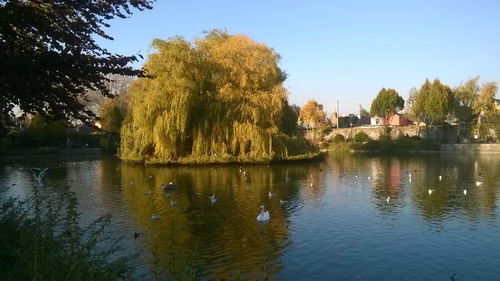
Blessington Street Basin (Michael Geraghty 2015)
One of North Dublin’s less-well-known treasures, this is Blessington Street Basin, off the (former) Broadstone Line of the Royal Canal. Thanks to Michael Geraghty for the photo, taken in November 2015.
Thon Sheugh and WI’s budget
A Sinn Féin MLA, whose party colleague is one of two ministers responsible for Waterways Ireland, has expressed concern about WI’s financial position:
Phil Flanagan: Is the [North South Ministerial] Council aware of the stark financial difficulties facing Waterways Ireland as a result of not only sustained budget cuts but the currency fluctuation because of the weakened euro? Let me point out some of the figures: compared with 2013, the 2014 budget was down by €290,000; and, in 2015, it was down by €875,000, solely because of the weak euro. Was that matter discussed? What potential solutions may ensure that Waterways Ireland is returned to a sustainable financial footing?
I had not realised the extent of the problems caused by the euro.
Replying, Martin McGuinness — also Sinn Féin — said
The fluctuation of the euro was not discussed at the meeting.
Obviously, it does represent a serious challenge, given the fact that the euro has been very weak over recent times. I note that it has strengthened over recent days. Certainly, on foot of the Member highlighting this, we can give it further consideration.
Mr McGuinness went on to provide some information about Saunderson’s Sheugh (which we’re pretending is the Ulster Canal):
It is important to point out that the work of Waterways Ireland is nearing completion, including the dredging of the River Finn between Upper Lough Erne — that will be of interest to the Member — and Castle Saunderson as part of phase 1 of the restoration of the Ulster canal.
Design plans for the new bridge at Derrykerrib are also at an advanced stage. I understand that there are some contractual issues with the site that, combined with high water levels, have led to delays.
However, Waterways Ireland is working with local councils and other interested parties to secure EU funding under the INTERREG sustainable transport programme. The proposed greenway would run from Smithborough village to the Monaghan town greenway and on to Armagh. The point that the Member raised is important and will be considered by the Council.
Given that that was irrelevant to the question, I presume that Mr McG wanted to get this information on the record.
I would like to know more about the “contractual issues with the site”. I do hope they won’t mean that we miss getting photos of the northern and southern ministers, wearing yellow hard hats and lifejackets, claiming credit for the work. After all, there is an election coming up.
Posted in Canals, Drainage, Economic activities, Engineering and construction, Extant waterways, Foreign parts, Historical matters, Industrial heritage, Ireland, Modern matters, Operations, Politics, Restoration and rebuilding, Ulster Canal, waterways, Waterways management, Weather
Tagged Clones, MLA, North South Ministerial Council, Saunderson's, sheugh, Sinn Fein
Lacustrine expansions
SHANNON (THE) , the largest river of Ireland, and probably the largest in any equal extent of insular ground in the world. […]
The lower third of its course is tidal or estuarial; and the other two-thirds are, in a comparative sense, so straight, so deep, so free from current, and so much aided by lacustrine expansions, that the river can be navigated by barges, and made an aqueous highway for commerce, to within a few miles of its source.
Were all its facilities to trade and communication as fully recognised and used as those of the rivers of England, it could not fail to relieve and enrich the condition of a very large proportion of the Irish population, and would be burdened with a much greater annual aggregate of freightage than any other river of equal length in the world; yet, in spite of its voluminousness, its highly navigable capacities, and its intimate connection with many of the most populous inland and central districts of Ireland, it was, till a few years ago, very little cared for, and continues to the present day to be comparatively little known.
It effects, from Lough Allen near its source, to the sea at the level of low-water, an aggregate descent of 159 feet in summer, or 163 feet in winter; or, to speak popularly, and with reference merely to high-water level, it makes an aggregate descent of 147 feet; but it achieves no less than 97 feet of the 147 in the brief distance between Killaloe and Limerick; and it also effects, within its entire course, no fewer than 17 different falls or rapids; so that, in its entire current, except at these few particular localities, it is necessarily sluggish and silent almost to stagnation.
Much of its strictly fluviatile extent consists of very large and long lacustrine expanses; much also consists of dull, dead reaches of river, stagnating amid callows, meadows, bogs, and morasses, rankly overgrown upon the sides by aquatic vegetation, and periodically spreading out in cold and shallow floods; and surprisingly little consists of the merry and brilliant combinations of limpid and rippling current with clean well-defined and picturesque banks which so generally constitutes the river-scenery of Scotland.
The Parliamentary Gazetteer of Ireland, adapted to the new poor-law, franchise, municipal and ecclesiastical arrangements, and compiled with a special reference to the lines of railroad and canal communication, as existing in 1844–45; illustrated by a series of maps, and other plates; and presenting the results, in detail, of the census of 1841, compared with that of 1831 Volume III N–Z A Fullarton and Co, Dublin, London and Edinburgh 1846
FPP (lapsed)
I mentioned flooded fields, zoned for housing, here. Michael Geraghty has very kindly sent on this photo, taken recently in Athlone.
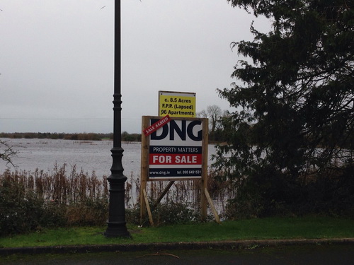
FPP (lapsed)
How nice to have a waterfront apartment. Though it may be a bit much to have it waterback, waterside, watertop and waterbottom as well.
If there is an award for sales skills amongst auctioneers, I wish to nominate Messrs DNG.
For certain values …
In the Irish Times of 5 January 2016 Fintan O’Toole has an article headed “Genuine local democracy part of the solution to flooding“. He points out that
- in 2004 the Irish Times property supplement showed a photograph [we are not told whether it was part of an ad or advertorial or of a critique of property development] showing a sign advertising for sale a flooded field that had been zoned for residential use
- in 1997 a resident of Clonmel detailed how the town’s natural flood defences had been destroyed
- in 1999 a man in Ennis blamed the flooding of his house on the granting of too many planning permissions
- in 2000 3500 Clonmel residents objected to building on flood plains
- nitwitted local councillors didn’t care.
He concludes that
As flooding gets worse, we will have to spend enormous amounts of money on engineering solutions. But in fact one part of the solution doesn’t cost any money at all. It’s called listening. Or, to give it its political title, it’s called genuine local democracy. Top-down, very expensive technocratic measures may have to be part of the response. But they will only work in a political culture that has eyes to look at the land and ears to listen to what people know about it.
Well, up to a point, Lord Copper. The article provides no evidence that a majority of the citizens — in any local authority area, Dáil constituency or other political unit — shares the erudite and enlightened views of those who write letters to, or columns in, the Irish Times. In fact, given that the citizens have, over more than one hundred years, continued to elect large numbers of nitwits to the local authorities and, for almost a century, to the Dáil, it seems unlikely that democracy — genuine, local or otherwise — will ever produce the right answers.
Which may explain why so much power now resides elsewhere, in the hands of experts and courtiers, and why elected representatives are reduced to throwing the occasional tantrum, providing tea and sympathy and making empty promises that then come back to haunt them.
Posted in Drainage, Economic activities, Engineering and construction, Extant waterways, Ireland, Irish waterways general, Modern matters, Natural heritage, Non-waterway, Operations, People, Politics, Safety, Shannon, Suir, waterways, Waterways management, Weather
Tagged 2015, 2016, democracy, elected representative, expert, FIntan O'Toole, flood, Irish Times, local authority, Lord Copper, oligarchy, politician, Shannon, Suir
Managing the Shannon
Sometimes you have to wonder about politicians and their grasp of reality. Take, for instance, young Mr Adams, Sinn Féin TD for Louth. There he was in the Dáil the other day, talking about flooding on the Shannon, and saying (amongst other things):
No single agency is responsible for the management of the River Shannon. Will the Taoiseach give full responsibility to the OPW for management of the Shannon?
Can Mr Adams have forgotten that, under the Good Friday Agreement, a cross-border implementation body called Waterways Ireland, reporting jointly to the Minister for Fairytales in the republic and the Minister for Marching Bands [a Sinn Féin MLA] in Northern Ireland, is responsible for navigation on certain named waterways including the Shannon?
Giving the Office of Public Works full responsibility for the management of the Shannon would require renegotiation of the Good Friday Agreement [and perhaps some later agreements]. I gather that the members of HM Devolved Administration in Northern Ireland delight in doing that sort of thing, but reducing the powers of the largest of the cross-border implementation bodies might not be wise.
Posted in Drainage, Economic activities, Engineering and construction, Extant waterways, Foreign parts, Ireland, Irish waterways general, Modern matters, Operations, People, Politics, Shannon, waterways, Waterways management, Weather
Tagged cross-borsder implementation bodies, drainage, flood, Gerry Adams, Good Friday agreement, Shannon, Sinn Fein
Shannon lake levels
According to the Shannon Catchment-based Flood Risk Assessment and Management (CFRAM) Study Technical Assessment: River Shannon Level Operation Review [PDF: Office of Public Works v2_0 July 2012]
ESB collects and maintains records of rainfall, river and lake levels and flow data. Even though ESB has no responsibility to supply flood warnings under their regulations, it issues twice weekly lake level forecasts to all the relevant stakeholders since 2010.
Those stakeholders include Waterways Ireland.
As the levels of the lakes are of great interest to boat-owners and others, it would be really nice if either the ESB or Waterways Ireland were to publish those forecasts. WI wouldn’t need any elaborate new system: they could send them around as marine notices, and the cost would be minimal.
But perhaps the forecasts are already published somewhere? If, Gentle Reader, you know where they are, do please leave a Comment [preferably with a link] below.
Posted in Drainage, Engineering and construction, Extant waterways, Ireland, Irish inland waterways vessels, Irish waterways general, Modern matters, Operations, Safety, Scenery, Shannon, Sources, Tourism, Water sports activities, waterways, Waterways management, Weather
Tagged boating, ESB, forecast, Ireland, lake, Shannon, water level, Waterways Ireland
