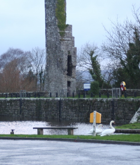
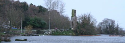
The Carrick-on-Suir creamery chimney (Shannon Scheme electrification)
The Carrick-on-Suir creamery chimney (Shannon Scheme electrification)
Posted in Ashore, Built heritage, Drainage, Economic activities, Engineering and construction, Extant waterways, Industrial heritage, Ireland, Operations, Safety, Scenery, Shannon, Suir, waterways, Waterways management, Weather
Tagged Ardnacrusha, Athlone, Banagher, bridge, Carrick-on-Suir, Clare, Cosgrave, creamery, electrification, ESB, floods, flow, Ireland, Operations, pylons, Shannon, Suir, waterways
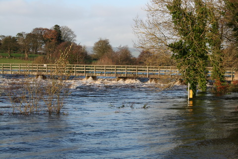
Parteen Villa Weir is sending large amounts of water down the original channel of the Shannon, and over the Falls of Doonass, to draw water off from the upper reaches of the river.
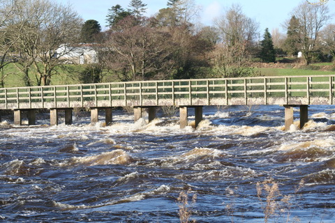
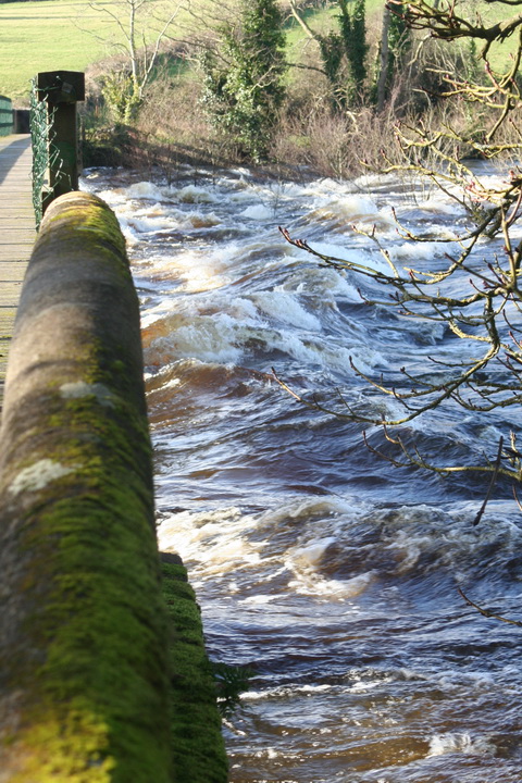
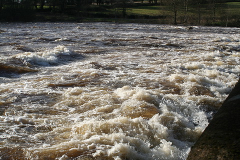
The footbridge at Castleconnell
Above the bridge
The downstream side of the bridge
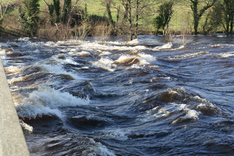
A bumpy ride
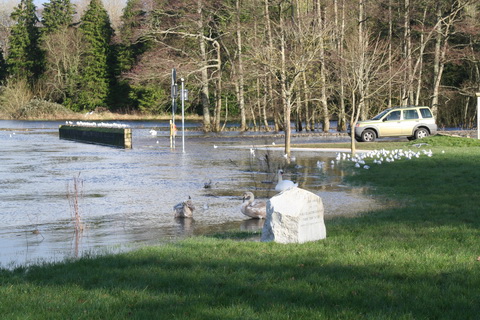
At normal levels the bottom of the wall is several feet above the water
Levels below Parteen Villa have not yet reached those of 2009 and the channel can probably take more before folk get flooded.
The Old River Shannon site has some photos taken at Parteen Villa Weir.
Posted in Built heritage, Canals, Charles Wye Williams, Drainage, Economic activities, Engineering and construction, Extant waterways, Industrial heritage, Ireland, Natural heritage, Operations, Safety, Shannon, Sources, Tourism, Water sports activities, waterways, Waterways management, Weather
Tagged boats, bridge, canal, Castleconnell, Clare, ESB, floods, flow, Ireland, Killaloe, Limerick, lost, O'Briensbridge, Operations, Parteen Villa Weir, quay, Shannon, turf, vessels, water level, waterways, Waterways Ireland, weir
Poolbeg: €280 per metre for a year plus membership; €20 a night for visitors.
Dun Laoghaire: €435 per metre with facilities for a year, €290 per metre without; €3.60 per metre per night for visitors.
Howth: €81 per metre per month; daily rate €3,20 per metre, minimum daily charge €20.
Grand or Royal Canal: current maximum €278 per year, irrespective of boat length, less than Dun Laoghaire charges per metre (for a berth with no facilities).
Admittedly you can go to more places from Dun Laoghaire (like, er, Holyhead), but on the other hand you can go boating from west Dublin in all but the most extreme conditions and there are more pubs along the way.
Posted in Canals, Economic activities, Engineering and construction, Extant waterways, Ireland, Irish inland waterways vessels, Operations, People, Politics, Sea, Sources, Water sports activities, waterways, Waterways management, Weather
Tagged boats, bridge, bye-laws, byelaws, canal, Dublin, Dun Laoghaire, Grand Canal, howth, Ireland, marina, mooring, Operations, Poolbeg, Royal Canal, waterways, Waterways Ireland
There was a proposal in the 1830s for a ship canal along the coast, outside the railway embankment, from Dublin to the asylum harbour at Kingstown. A preliminary report was provided by William Cubitt after the House of Commons Select Committee on the Dublin and Kingstown Ship Canal had reported in July 1833.
Henry E Flynn was opposed to the idea and, in his A Glance at the Question of a Ship Canal connecting the asylum harbour at Kingstown with the river Anne Liffey at Dublin &c &c &c [George Folds, Dublin 1834], dedicated to Daniel O’Connell, he wrote eloquently of the drawbacks of the proposal, which included this:
Be it remembered, that the whole coast from Ringsend to Merrion is the bathing ground for the less affluent classes of the Citizens; and hundreds get their bread by attending on and bathing the females who frequent it.
And are the patriotic Would-be’s who support a Ship Canal equally reckless of the health, the morality, and the existence of those persons? Would they have no objection to expose their mothers, wives, sisters and daughters to the immediate wanton gaze, the scoffs, the jeers, the immodest jest, the filthy exposure and indecent exhibitions which the most abandoned race of men [ie sailors] could find in their dissolute minds to perpetrate in their view, and within their hearing? And yet, all this must be the consequence of a Ship Canal in the immediate vicinity of the female baths and bathing ground along the line.
Happily, the canal was never built.
Posted in Ashore, Built heritage, Canals, Charles Wye Williams, Drainage, Economic activities, Engineering and construction, Extant waterways, Industrial heritage, Ireland, Non-waterway, Operations, People, Politics, Rail, Safety, Sea, Shannon, Sources, Steamers, The cattle trade, The fishing trade, Tourism, Water sports activities, waterways, Waterways management, Weather
Tagged cattle, Daniel O'Connell, Grand Canal Dock, Henry E Flynn, Liffey, North Wall, Richard Bourne, strand, William Cubitt, women
I reported in October and in November on the lowering of the level of Lough Ree, in advance of heavy rain, to see whether that would help to manage flooding on the Shannon Callows further downstream.
The interim data from the experiment is available on the OPW website here [seven-page PDF]. The conclusion is:
Conclusion
From the water level records, it is apparent that the closing of the gates at Athlone weir in anticipation of a rise in water levels on Lough Ree led to a temporary lowering of the Shannon water levels immediately downstream of Athlone. This possibly delayed inundation of the Shannon callows downstream of Athlone by a number of days. To determine whether the extent or depth of eventual inundation was in any way reduced by the experiment will require more detailed analysis by the CFRAM consultants. Data is available on request from Hydrometric Section if required.
It should be stressed that this is an interim report. This CFRAM background document [PDF] is still useful.
It is not clear to me why the state should spend any money improving the value of privately owned riverside land that is of marginal benefit to the economy.
Posted in Ashore, Drainage, Economic activities, Engineering and construction, Extant waterways, Ireland, Irish waterways general, Natural heritage, Operations, People, Politics, Shannon, Sources, The cattle trade, waterways, Waterways management, Weather
Tagged Athlone, callows, CFRAM, ESB, floods, flow, Ireland, Jacobs, Lough Ree, Office of Public Works, Operations, OPW, Shannon, water level, waterways, Waterways Ireland
One of the problems with all this newfangled technology is that some things — like, for instance, copying a block of text from one document into another – are so easy that folk may forget to check their work afterwards.
Consider, for instance, the Office of Public Works, which seems to have a block of boilerplate text ready for answering written boilerplate questions from midlands TDs who have discovered that things get wet when it rains.
On 22 January 2014 Denis Naughten [Ind, Roscommon/South Leitrim, which — let it be admitted — The Lord intended to be rather boggy and sad] had this question:
To ask the Minister for Public Expenditure and Reform the steps being taken to address flood risks within the Shannon basin; and if he will make a statement on the matter.
The answer tells Mr Naughten about CFRAM — nothing he didn’t know before he asked, I imagine — but it included this sentence:
On foot of discussions between my colleague, Minister of State Hayes and the IFA, and with the cooperation of both the ESB and Waterways Ireland, a water level monitoring exercise is being carried out as part of the CFRAM process which will allow for analysis of water flows and levels at key points around the Lough Ree and Callows areas.
The highlighting is mine: it seemed a bit odd because this written answer was allegedly being given by Mr Hayes.
Mr Naughten had another Q&A here, but it’s not very interesting.
Posted in Ashore, Drainage, Economic activities, Engineering and construction, Extant waterways, Ireland, Irish waterways general, Natural heritage, Operations, People, Politics, Shannon, Sources, The cattle trade, waterways, Waterways management, Weather
Tagged boats, CFRAM, ESB, floods, flow, Ireland, Office of Public Works, OPW, Shannon, water level, waterways, Waterways Ireland, weir
The ESB is currently letting more water down the old course of the Shannon, from Parteen Villa Weir through O’Briensbridge, Castleconnell and the Falls of Doonass. This channel gets the first 10 cubic metres per second from the Shannon; the next 400 go through Ardnacrusha and anything left over is sent down the old course.
The result is to help to reduce the water level on Lough Derg while raising it on the old course.
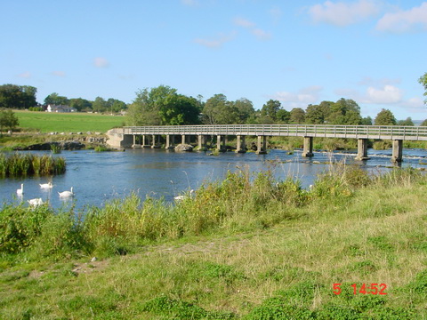
The footbridge in Castleconnell at normal summer level in 2002
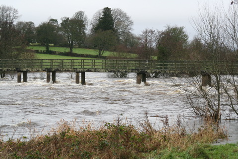
The footbridge on 1 January 2014
Before Ardnacrusha was built, the old channel took the entire flow of the Shannon, so it can take more than it has now.
The footbridge in the floods of November 2009
The level is still below that of 2009, when the land around the old channel flooded in several places. But much land is waterlogged: I saw yesterday that the upper reaches of the Nore, the Barrow and other rivers were in flood. And more rain is forecast.
Wouldn’t it be nice if some of that could be sent to Dublin instead? I see that some folk claim (on what looks like a website that hasn’t been updated for a while) that the evil Dublin folk want to extract 350 million litres of water from the Shannon every day; the original idea was to take it from Lough Ree but now it seems that Lough Derg is the preferred source.
Now 350 million litres sounds like a lot, but it’s 350 000 cubic metres per day, 14 583.3 per hour, 243.05 per minute, 4.05 per second, which is less than 1% of normal flow through the two channels draining Lough Derg. There’s a lot more at the moment, and the good citizens of Dublin are welcome to come down and fill their buckets. I suspect that Clare TD Michael McNamara has got things out of proportion.
Addendum: 350 million litres per day, over a lake whose area is 130 square kilometres, would lower the level of the lake (if my calculations are correct) by 2.69 millimetres. If no water entered the lake, the level would be down 983 mm after a year, ignoring evaporation and other abstractions and assuming that the Shannon and other tributaries no longer flowed in and that there was no rain.
Posted in Ashore, Built heritage, Drainage, Economic activities, Engineering and construction, Extant waterways, Industrial heritage, Ireland, Natural heritage, Non-waterway, Operations, People, Politics, Shannon, shannon estuary, Sources, waterways, Waterways management, Weather
Tagged abstraction, Ardnacrusha, boats, canal, Castleconnell, Clare, Dublin, ESB, estuary, floods, flow, Ireland, Killaloe, Lough Derg, O'Briensbridge, Operations, Shannon, water level, waterways
Interesting BBC story about a possible cause for the decline in the number of eels.
Posted in Economic activities, Engineering and construction, Extant waterways, Foreign parts, Ireland, Natural heritage, Non-waterway, Operations, Sea, Shannon, shannon estuary, Sources, The fishing trade, waterways, Waterways management, Weather
Tagged anguilla anguilla, eels, Ireland, Operations, Shannon, waterways

The ramp to the pontoons in Dromineer is now sloping upwards
The water level at Banagher has risen about one metre in the past 35 days.

Dromineer people need to drink more wine

The ghost ship is back

Dromineer sans ivy
Garrykennedy
Garrykennedy from a distance

Miranda in Dromineer

Garrykennedy 1

Fewer boats in WI berths this year, I think
Garrykennedy 2
Posted in Ashore, Built heritage, Charles Wye Williams, Economic activities, Engineering and construction, Extant waterways, Industrial heritage, Ireland, Irish inland waterways vessels, Restoration and rebuilding, Safety, Scenery, Shannon, Sources, waterways, Waterways management, Weather
Tagged Banagher, boats, Drominer, Garrykennedy, Ireland, Lough Derg, Operations, Shannon, Tipperary, vessels, Waterways Ireland

