
-

Waterways and Means by Brian J Goggin available now -
Join 587 other subscribers
RSS links
Pages
- Waterways & past uses
- Saving the nation
- Turf and bog navigations
- The Bog of Allen from the Grand Canal in 1835
- John’s Canal, Castleconnell
- The Canal at the World’s End
- The Finnery River navigation
- The Lough Boora Feeder
- The Little Brosna
- The Lullymore canal as wasn’t
- The Roscrea canals
- The Monivea navigations
- Lacy’s Canal
- The Rockville Navigation page 1
- The Rockville Navigation page 2
- The Rockville Navigation page 3
- Rockingham
- The Colthurst canals
- The Inny navigation
- The lower Shannon
- The piers, quays and harbours of the Shannon Estuary
- Nimmo’s non-existent harbour
- The Doonbeg Ship Canal
- Querrin
- Kilrush and its sector lock
- The Killimer to Tarbert ferry
- The Colleen Bawn at Killimer
- Knock knock. Who’s there?
- Cahircon: not at all boring
- Ringmoylan
- The hidden quay of Latoon
- The stones of Kilteery
- The Maigue
- Sitting on the dock of the Beagh
- Massy’s Quay, Askeaton and the River Deel
- Saleen Pier
- The Lord Lieutenant’s Visit to Limerick — trip down the Shannon [1856]
- The Fergus
- The Limerick Navigation
- The boundaries of the Shannon
- The power of the Shannon
- The locks on the Limerick Navigation
- Plassey
- Worldsend, Castleconnell, Co Limerick
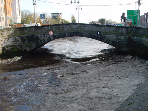
- The bridge at O’Briensbridge
- The Limerick Navigation and the Monmouthshire Canal
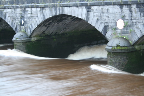
- The Limerick Navigation (upper end) in flood November 2009
- The Limerick Navigation (lower end) in flood November 2009
- The Limerick Navigation (tidal section) in flood November 2009
- Floods in Limerick (1850)
- Limerick to Athlone
- The piers, quays and harbours of the Shannon Estuary
- The middle and upper Shannon
- The Grand Canal
- Monasterevan, the Venice of the west
- The Grand Canal lottery
- Grand Canal carrying: some notes
- The dry dock at Sallins
- The Naas Branch
- The Mountmellick Line of the Grand Canal
- Dublin to Ballinasloe by canal
- The Ballinasloe Line
- A Grand Canal lock: Belmont
- South of Moscow, north of Geneva
- Water supply to the Grand Canal
- The Grand Canal Company strike of 1890
- The Royal Canal
- Water supply to the Royal Canal: the feeders
- The Lough Owel feeder
- The proposed Lough Ennell water supply to the Royal Canal
- From Clonsilla to Clew Bay
- Kinnegad and the Royal Canal
- The sinking of the Longford in 1845
- Steamers on the Royal Canal
- Leech of Killucan: horse-drawn boats on the Royal
- Horses on board
- Royal eggs
- Prothero on the Royal
- The whore who held the mortgage on the Royal Canal
- Waterways in Dublin
- The Naller
- Visit Dublin. Walk canals. Drink beer.
- The Broadstone Line of the Royal Canal
- Effin Bridge: its predecessors
- Between the waters
- The abandoned Main Line of the Grand Canal 1
- The abandoned Main Line of the Grand Canal 2
- The abandoned Main Line of the Grand Canal 3
- The abandoned Main Line of the Grand Canal 4
- Waterways of the south-east
- Waterways of Cork and Kerry
- Waterways of the west
- Waterways of Ulster and thereabouts
- People
- Systems & artefacts
- Irish waterways furniture
- Irish waterways operations
- Miscellaneous articles
- Irish inland waterways vessels
- Cots -v- barges: defining Irish waterways
- Waterways Ireland workboats
- Wooden boats on Irish inland waterways
- Traditional boats and replicas
- Non-WI workboats
- Older Irish working boats
- The barge at Plassey
- Dublin, Athlone and Limerick
- Waterford to New Ross by steam
- The steamer Cupid
- Liffey barges 1832
- Steam on the Grand Canal
- The Mystery of the Sunken Barge
- Steam on the Newry Canal
- Guinness Liffey barges 1902
- Up and under: PS Garryowen in 1840
- Watson’s Double Canal Boat
- The Cammoge ferry-boat
- The ’98 barge
- Late C19 Grand Canal Company trade boats
- Chain haulage
- Ballymurtagh
- The Aaron Manby and the Shannon
- A sunken boat in the Shannon
- Sailing boats on Irish inland waterways
- Some boats that are … different
- Square sail
- 4B mooring
- Irish waterways scenery
- Engineering and construction
- Irish navigation authorities
- Opinion
- The folly of restoration
- The Ulster Canal now
- The Ulster Canal 00: overview
- The Ulster Canal 01: background
- The Ulster Canal 02: the southern strategic priority
- The Ulster Canal 03: implementation
- The Ulster Canal 04: Ulster says no
- The Ulster Canal 05: studies and appraisals
- The Ulster Canal 06: the costs
- The Ulster Canal 07: the supposed benefits
- The Ulster Canal 08: the funding
- The Ulster Canal 09: affordability
- The Ulster Canal 10: kill it now
- The Ulster Canal 11: some information from Waterways Ireland (and the budget)
- The Ulster Canal 12: departmental bullshit
- The Ulster Canal 13: an investment opportunity?
- The Ulster Canal 14: my search for truth
- The Ulster Canal 15: spinning in the grave
- The Ulster Canal 16: looking for a stake
- The Ulster Canal 17: the official position in November 2011
- The Ulster Canal 18: Sinn Féin’s canal?
- The Ulster Canal 19: update to February 2012
- The Ulster Canal 20: update to April 2013
- The Ulster Canal 21: update to August 2018
- The Barrow
- A bonfire at Collins Barracks
- Living on the canals
- Waterways tourism
- Guano
- The Park Canal: why it should not be restored
- The Park Canal 01: it says in the papers
- The Park Canal 02: local government
- The Park Canal 03: sinking the waterbus
- The Park Canal 04: the Limerick weir
- The Park Canal 05: cruisers from the Royal Canal
- The Park Canal 06: What is to be done? (V I Lenin)
- The Park Canal 07: another, er, exciting proposal
- Accounting for risk
- Tax-dodging boat-owners
- Rail
- Waterways & past uses
Blogroll
boats
- Canal steamers [UK]
- Chris Deuchar's boating page
- Douglas Self retrotech and steam
- Grace's Guide: British Industrial History
- Heritage Boat Association
- Historic Inland Working Boats
- Irish maritime history
- irish shipwrecks database
- Kilrush & District Historical Society
- Lough Corrib charts and scans
- Railway and Canal Historical Society
Book sales
Industrial heritage
Inland waterways
Ireland
Overseas
Seafaring
Sources
Tag Archives: floods
The corncrake and the decline of religion
On 13 February 2013 the Irish Times reported that a farmers’ representative had told politicians that
Farmers in the Shannon callows are facing extinction along with the corncrake and wading birds […].
He wanted taxpayers’ money to be spent on stopping the river flooding its flood plain.
Back in the days when people believed in gods, they would have known what a flood meant: it was a message from a deity, telling them to stop whatever they were doing. On the Shannon, either people have stopped believing in gods or they are having some difficulty in interpreting the message, despite its having been delivered over and over again for hundreds of years. If it were interpreted properly, or even if landowners had a modicum of common sense, they would realise that they should either cease trying to earn a living along the banks of a river that floods regularly or adapt their expectations or their activities to take account of the floods (one thinks of rice paddies …).
In the years 2009–2011 net subsidies to agriculture in the Midland region were 114.4% of the operating surplus. For the Border, Midland and Western region as a whole, the figure was 110.4%. In other words, agriculture in those regions is, on balance, a form of outdoor therapy for landowners: it is not an economic activity, and there is no point in taxpayers’ spending any more money on it.
Posted in Ashore, Drainage, Economic activities, Engineering and construction, Extant waterways, Ireland, Natural heritage, Operations, People, Politics, Scenery, Shannon, Sources, The cattle trade, waterways, Waterways management, Weather
Tagged agriculture, farming, floods, Shannon, waterways, Waterways Ireland
The glory that was Greese
The River Greese is a tributary of the River Barrow, joining it below Maganey Lock. The photo is taken from the road on the west bank of the Barrow.
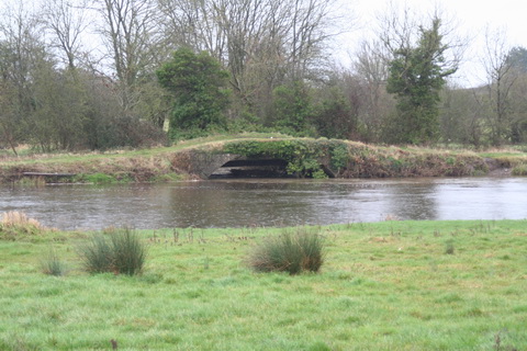
The Greese joins the Barrow: the trackway passes over it on a bridge
You can locate it on the OSI map by zooming out from here; the extract below shows the confluence.
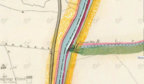
The confluence
![]()
Posted in Ashore, Built heritage, Drainage, Economic activities, Engineering and construction, Extant waterways, Industrial heritage, Ireland, Natural heritage, Operations, Scenery, waterways, Weather
Tagged Barrow, bridge, Carlow, floods, flow, Grand Canal, Greese, Ireland, Laois, Maganey, Operations, Shrule, waterways
The Suir towing-path
His late Most Excellent Majesty Henry the Eighth, by the Grace of God, King of England and France, Defender of the Faith, Lord of Ireland and of the Church of England and also of Ireland in Earth Supreme Head, has many claims to fame, but the greatest is undoubtedly his Act for the Weares upon the Barrow, and other Waters in the County of Killkenny of 1537, which begins thus:
Prayen the commons of this present Parliament assembled, That where at all times necessarie boates, scowts, wherries, clarans, cottes, and other vessels, loden and bestowed with goods, merchandizes, and other stuffe, have beene used to passe and repasse thorough and in the King’s most excellent Majesty’s rivers and waters of the Barrow, the Noyre, the Suyr, and the Rie, within this land, which Rie is in the county of Kilkenny, to and from the King’s citie of Waterford, and the townes of Kilkenny, Rosse, and Clomel [sic], to and from diverse borrowe and corporate townes, and other places, being sitiated in the counties of Kyldare, Catherlagh, Wexford, Kilkenny, Waterford, and Tipperary, through which great commoditie and profit hath growen and might grow to the said citie, townes, noroughes, and other places, and to all and every the King’s true subjects adjoyning to the same waters and rivers: […]
We resume a couple of pages later:
[…] and that the said owners, their servants, marryners, boatmen, and other rulers and conveyers, and all other persons coming in ayd and help of them and every of them, at all such times as the said mariners, boatemen, and other rulers and conveyers shall thinke the same necessarie and needfull, shall have and occupie at every of their wills and pleasures, the space and breadth of seven foote or more, as need require, of plain ground, upon every part of the land, of every side of every the said rivers and waters, next adjoyning to the said rivers and waters, and that to bee where they must needs draw the said boats and other vessels afore named, with strength of horses or men, by land […].
So His late Most Excellent Majesty provided that those drawing boats, using manpower or horsepower, could use a space seven foot wide on either side of the river. From the 1750s onwards, work was done on building a towing-path along the Suir between Carrick and Clonmel; work seems to have been finished before 1789 and the towing-path continued in use until the early years of the twentieth century.
Kincor Castle below Sir Thomas’s Bridge at Ferryhouse
Much, but not all, of the towing-path is accessible, and maintainted by South Tipperary County Council; as well as providing a walking route, it allows anglers, boaters and other leisure users to get to the river. However, some sections are impassable, so that it is not possible to walk the whole length of this extremely scenic route between Clonmel and Carrick.
South Tipperary County Council is now considering declaring public roads on the towing-path and thus taking it in charge.

South Tipperary County Council’s newspaper ad about declaring public roads on the Suir towing-path
The Council’s documents are here. I think that this is a good idea and I have written to the Council (and to local newspapers) to declare my support.
Posted in Ashore, Built heritage, Economic activities, Engineering and construction, Extant waterways, Forgotten navigations, Industrial heritage, Ireland, Operations, People, Politics, Restoration and rebuilding, Sources, Suir, Tourism, Water sports activities, waterways, Waterways management
Tagged access, angling, Barrow, boats, bridge, Carrick-on-Suir, Clonmel, Deerpark, Ferryhouse, floods, flow, Ireland, King Henry VIII, Operations, public road, Suir, take in charge, Tipperary, towing-path, towpath, vessels, walking, water level
The fear of Baal’s Bridge
In May 1895 the fear induced by the prospect of a passage under Baal’s Bridge, on the Abbey River in Limerick, as revealed in the commercial court in London before Mr Justice Mathew and reported by the Freeman’s Journal of 20 May 1895.
Arthur George Mumford of Colchester, Essex, was described as an agent, but was actually a marine engineer and manufacturer of steam engines. He owned a 25-ton steam yacht called Gipsy, which he decided to sell through Messrs Cox & King, the well-known yachting agents (their 1913 catalogue is here).
The buyer was Ambrose Hall, the man responsible for the statue of Patrick Sarsfield. A former mayor of Limerick, he was an alderman and a “house and land commission agent”; his address was given as Mignon House, Limerick, which I have not so far found.
Hall bought the boat for £500; it was to be delivered to him at Limerick. The original plan was to sail it around the coast of Ireland and up the Shannon estuary, but bad weather in late 1894 caused Cox & King to suggest taking it to Dublin and then down the Grand Canal and the Shannon to Limerick. Hall agreed; the boat left Dublin in January 1895. It reached Killaloe on 19 January and Limerick “a day or two afterwards”, where it was moored in the canal harbour.
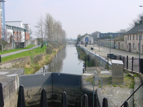
Canal harbour, Limerick in March 2007
Hall refused to accept the boat in the canal, saying that it should have been delivered to Limerick dock, a short distance downstream. Mumford and Cox & King sued him and the National Bank.

Ordnance Survey ~1900
Hall, an alderman and a former mayor, who had lived at North Strand, presumably knew the river and its difficulties.
Baal’s Bridge looking upstream towards the canal harbour in the floods of 2009
The navigation arch at Mathew Bridge looking downstream in the floods of 2009
It was contended by the defendant that to get the vessel from the canal into the estuary of the Shannon there was a considerable risk involved. The passage was only a few hundred yards, but it was stated it could only be effected at certain states of the tide when it would be possible to get through Ballsbridge.
The judge sensibly suggested that it should be possible to insure the boat for the journey; the plaintiffs agreed to deliver it; Hall agreed to accept delivery and to pay £15 for the cost of the caretaker who had been looking after the boat since 23 January; the case was settled.
Clearly Ambrose Hall didn’t know Pat Lysaght.
![]()
Posted in Built heritage, Charles Wye Williams, Economic activities, Engineering and construction, Extant waterways, Foreign parts, Forgotten navigations, Industrial heritage, Ireland, Irish inland waterways vessels, Natural heritage, Operations, People, Shannon, shannon estuary, Sources, Steamers, Tourism, Water sports activities, waterways
Tagged Abbey River, Ambrose Hall, Baal's Bridge, boats, bridge, canal, Clare, Colchester, Cox & King, Dublin, estuary, floods, flow, Gipsy, Grace, Grand Canal, Ireland, Killaloe, Limerick, lock, Mumford, O'Briensbridge, Operations, Pat Lysaght, quay, Shannon, steam yacht, steamer, vessels, water level, waterways
