Tag Archives: Clonmel

State of trade on the River Suir [1842]

People who read this will hardly believe that such a state of things, as it details, can exist in any portion of the British dominions; and yet, in the year 1842, undoubtedly in Ireland, and in Ireland only, can we find such facts — positive facts.

It is still more surprising to find that this extraordinary state of things should exist on a river on which a very considerable export and import trade passes — and yet so it is.

A fair challenge to the Chambers of Commerce of Clonmel and Waterford is now given. Let them deny the following data, if they can, seriatim, honestly and plainly:—

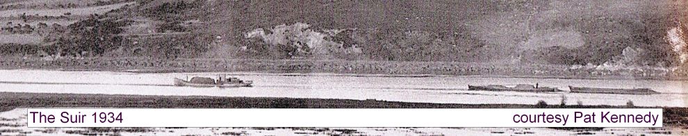
  1. That the boat trade between Clonmel and Waterford is in the hands of so few persons that it is, in truth and fact, a monopoly to all intents and purposes.
  2. That those corn factors, who export their produce by these boats, are allowed to import coal, iron, timber, groceries, or other goods, at a lower rate of freight than merchants or shopkeepers, who only import those articles, and do not export.
  3. That combination exists amongst the boatmen to such an extent, that they are, in point of fact and truth, the masters of the river, and have in reality succeeded in their “strikes”.
  4. That only a certain fixed number of boats are allowed to ply on the river, and that when a new boat is built, part of an old boat must be worked up into the new one.
  5. That although great improvements have been effected at Carrick in deepening the river, and thus bringing up vessels to the new quay there, the boatmen of Clonmel and Carrick will not navigate any boats from Clonmel which are to ship their cargoes at Carrick, but they insist and do take such boats on to Waterford.
  6. That when the bill for the Limerick and Waterford railway passed, and £100000 was granted in aid — which railway was to pass through Carrick, Clonmel, Caher, and Tipperary — not one merchant in Clonmel took a share.
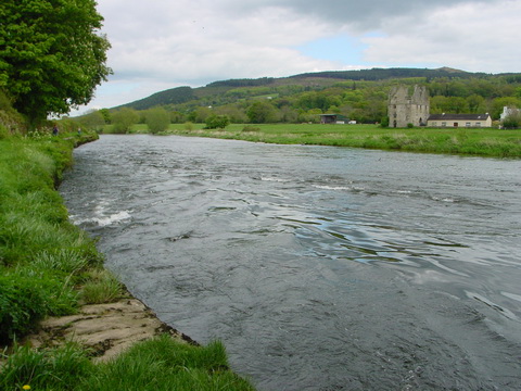
  7. That the exports of Waterford amount to above two millions annually, a considerable proportion of which is the produce of the vally [sic] of the Suir, and descends that river.
  8. That the state of the river Suir, as a navigation, between Clonmel and Carrick, is the worst in Ireland; that the import trade in these boats is dragged up the river by horses; that great delays take place, to such an extent, that the import trade suffers most considerably, to the detriment of every person in the community.
  9. That the expenses of the towing path &c fall upon the county at large.

Can it then be matter of surprise that, under such circumstances, Ireland is so much behind hand as she is?

Dublin Evening Mail 28 March 1842

A new sporting opportunity for the Suir?

This could work, from Carrick-on-Suir up to Clonmel, as there is already a towing-path.

Crossing the Barrow

The trackway [towing-path] on the River Barrow changes from the east {left) bank to the west at Leighlinbridge and back again at Graiguecullen/Carlow.

It seems to me that there may have been some difficulties in getting horse-drawn boats from one side of the river to the other and I have found no evidence on how it was done, so here is some speculation instead.

Boat Trade on the Barrow

BOAT TRADE

Dublin to and from Waterford
CALLING AT ROSS AND GRAIGUE

The Public are respectfully informed that the Boats of the BARROW NAVIGATION COMPANY call regularly each week to and from the above-mentioned Towns, say on the Mornings of MONDAY and THURSDAY, at Three o’Clock, making TWO deliveries weekly at each end.

The Company having selected Men of the besst characters as Masters of their Boats, they engage the safe delivery of all Goods forwarded, and hope by moderate charges and dispatch to give satisfaction.

GOODS FOR ENGLAND AND SCOTLAND to be forwarded by these Boats, should be directed to the Agents of the Company.

Goods can be forwarded by careful carriers to the following towns, viz:

FROM FROM FROM Waterford
Graigue To
To Ross Carrick-on-Suir
Borris Clonmel
Innistiogue To Dungarvan
Thomastown Dunmore
Enniscorthy Ballyhack
Wexford Tramore

For further particulars, apply to the Company’s Agents

Mr JOHN KELLY, Grand Canal Harbour, Dublin

Mr JOHN M’DONNELL, Custom-House Quay and Lower Thomas-street, Waterford

Mr M W CARR, New Ross

Mr M RYAN, Graigue

Or to the Secretary of the Company, P D LaTOUCHE, Esq, Castle-street, Dublin

Waterford Chronicle 4 November 1854

Carrick-on-Suir to Clonmel towing-path

Messrs RPS, consulting engineers, have been asked by South Tipperary County Council

… to design a minimal impact walking & cycling greenway route along the towpath of the River Suir between the towns of Clonmel and Carrick-on-Suir.

I have written about this stretch of the river here, so I was pleased to be asked to submit some comments and I welcomed the proposal. I made three suggestions, commenting more on principles than on details, which local people would know more about than I do.

First, I said that the heritage artefacts along the route should be protected and, if possible, explained. That might be done unobtrusively by making online information available to those equipped with smartphones. Such systems are used by the Canal & River Trust in Britain (here’s an example) and I understand that there have been experiments in using them on the Royal Canal here.

Second, I said that use by walkers requires more than a good trail: walkers also need safe parking places for their cars and information about public transport services that will return them to their starting-points. Car parks themselves need not be along the greenway but the information has to be provided there.

Third, there is scope for more use of the waterway itself, especially by canoes, kayaks and rafts, as well as by anglers. While such uses are (I imagine) outside RPS’s brief, I thought that it would be better to take account now of the needs of such users, and to ensure that the engineering would be able to cater for them in the future (I was not proposing that facilities necessarily be provided now), rather than to have to re-engineer the greenway later. My main concern was provision for enhanced access by rescue services, and Carrick-on-Suir River Rescue would probably be the best people to comment on that. I also suggested that a certain amount of unobtrusive hard edging along the towing-path might be of assisstance to boaters.

If you’ve looked at my page on this section of the Suir, you’ll know that it’s very scenic. Up to now, not all of the route has been accessible and making it so is a Good Thing — and at relatively low cost.


Canal carrying 1846: Dublin to Waterford

Lowtown is at the western end of the summit level of the Grand Canal; it thus has some claim to be the highest point on the canal. It is close to the village of Robertstown in County Kildare.

Lowtown is also the site of the junction between the main (Dublin to Shannon) line of the Grand Canal and its most important branch, the Barrow Line.

Lowtown (OSI ~1840)

Lowtown (OSI ~1840)

The main line from Dublin comes in from near the bottom right and exits near the top left. The two cuts leaving near the bottom left are the Old and New Barrow Lines, which join together just off the map. The Barrow Line runs to Athy, in south County Kildare, from which the Barrow [river] Navigation runs to the tidal lock at St Mullins, downstream of Graiguenamanagh.

The River Nore joins the Barrow a litle further downstream; the Nore is navigable on the tide upstream to Inistiogue. The combined rivers flow south through the port of New Ross and eventually join the estuary of the River Suir. Turning right at that point takes you up the Suir to Waterford, Carrick-on-Suir and Clonmel. Thus the Barrow Line, from Lowtown, forms an inland waterway link between Dublin and some towns along the Barrow, Nore and Suir.

Isaac Slater’s Directory[i] of 1846 lists those carrying goods on inland waterways. There is a long list for Dublin; entries for other towns list those providing local services. There are some conflicts between the lists (see below).

The map below shows those carrying on the Barrow Line of the Grand Canal and on the rivers Barrow, Nore and Suir. Each carrier is assigned a colour, which is used to frame the name of each place served by that carrier. Some towns (Mountmellick, Carrick-on-Suir, Clonmel) are off the map, further to the west. Note that the map is from the 25″ Ordnance Survey map of around 1900 rather than the 6″ of around 1840: I used it because it was clearer, but it shows features (eg railway lines) that were not present in 1846.

Click on the map to get a slightly larger version.

Dublin to Waterford: inland waterway traders 1846 (OSI)

Dublin to Waterford: inland waterway carriers 1846 (OSI)

Notes

All but one of the carriers are shown as having Dublin premises at Grand Canal Harbour, James Street. The exception is Gaven & Co, which is mentioned only in the Mountmellick entry.

I have not included the Grand Canal Company’s passenger-carrying boats, which carried parcels but not goods.

The City of Dublin Steam Packet Company entry for Dublin does not include Portarlington and Mountmellick amongst the towns served but the entry for Mountmellick says that the company’s boats leave for Dublin every Tuesday and Friday (its agent being John White) while that for Portarlington says they leave weekly. Boats from Mountmellick had to pass through Portarlington as well as Monastereven and other towns en route to Dublin.

Similarly, the entry for Mountmellick says that the Hylands boats leave there every other day while that for Portarlington says that they pass through weekly.

There is a page missing from the electronic copy of the directory that I consulted so the entry for Monastereven is incomplete.

The entry for Carlow says

To DUBLIN, and also to [New] ROSS, Boats depart, at uncertain periods, from the Wharfs of Lawrence and James Kelly, the Quay.

It does not say whether Lawrence and James Kelly owned any boats. They may have had boats but used them only for their own goods.

The entry for Mountmellick says “Bryan Hyland” rather than “B Hylands”.

The entry for Mountmellick includes the only mention I have found of Gaven & Co’s boats (James Waldron, agent).

The entry for Rathangan says

There are Boats for the conveyance of Goods, but no fixed period of departure.

Thomas Berry & Co, the most important carrier on the Grand Canal, did not venture south of Lowtown.

More

As far as I know, little has been written about the carrying companies, especially those of the nineteenth century. I would be glad to hear from anyone who can correct, supplement or comment on this information.


[i] I Slater’s National Commercial Directory of Ireland: including, in addition to the trades’ lists, alphabetical directories of Dublin, Belfast, Cork and Limerick. To which are added, classified directories of the important English towns of Manchester, Liverpool, Birmingham, Sheffield, Leeds and Bristol; and, in Scotland, those of Glasgow and Paisley. Embellished with a large new map of Ireland, faithfully depicting the lines of railways in operation or in progress, engraved on steel. I Slater, Manchester, 1846

My OSI logo and permit number for website

News from the Suir

Some chap from Limerick has been quoted in the Nationalist (Clonmel) as supporting South Tipperary County Council’s proposed taking in charge of the towing-path between Carrick-on-Suir and Clonmel.

And Carrick-on-Suir River Rescue needs help raising funds to buy a premises.

The Suir towing-path

His late Most Excellent Majesty Henry the Eighth, by the Grace of God, King of England and France, Defender of the Faith, Lord of Ireland and of the Church of England and also of Ireland in Earth Supreme Head, has many claims to fame, but the greatest is undoubtedly his Act for the Weares upon the Barrow, and other Waters in the County of Killkenny of 1537, which begins thus:

Prayen the commons of this present Parliament assembled, That where at all times necessarie boates, scowts, wherries, clarans, cottes, and other vessels, loden and bestowed with goods, merchandizes, and other stuffe, have beene used to passe and repasse thorough and in the King’s most excellent Majesty’s rivers and waters of the Barrow, the Noyre, the Suyr, and the Rie, within this land, which Rie is in the county of Kilkenny, to and from the King’s citie of Waterford, and the townes of Kilkenny, Rosse, and Clomel [sic], to and from diverse borrowe and corporate townes, and other places, being sitiated in the counties of Kyldare, Catherlagh, Wexford, Kilkenny, Waterford, and Tipperary, through which great commoditie and profit hath growen and might grow to the said citie, townes, noroughes, and other places, and to all and every the King’s true subjects adjoyning to the same waters and rivers: […]

We resume a couple of pages later:

[…] and that the said owners, their servants, marryners, boatmen, and other rulers and conveyers, and all other persons coming in ayd and help of them and every of them, at all such times as the said mariners, boatemen, and other rulers and conveyers shall thinke the same necessarie and needfull, shall have and occupie at every of their wills and pleasures, the space and breadth of seven foote or more, as need require, of plain ground, upon every part of the land, of every side of every the said rivers and waters, next adjoyning to the said rivers and waters, and that to bee where they must needs draw the said boats and other vessels afore named, with strength of horses or men, by land […].

So His late Most Excellent Majesty provided that those drawing boats, using manpower or horsepower, could use a space seven foot wide on either side of the river. From the 1750s onwards, work was done on building a towing-path along the Suir between Carrick and Clonmel; work seems to have been finished before 1789 and the towing-path continued in use until the early years of the twentieth century.

Kincor Castle below Sir Thomas's Bridge at Ferryhouse

Kincor Castle below Sir Thomas’s Bridge at Ferryhouse

Much, but not all, of the towing-path is accessible, and maintainted by South Tipperary County Council; as well as providing a walking route, it allows anglers, boaters and other leisure users to get to the river. However, some sections are impassable, so that it is not possible to walk the whole length of this extremely scenic route between Clonmel and Carrick.

South Tipperary County Council is now considering declaring public roads on the towing-path and thus taking it in charge.

South Tipperary County Council's newspaper ad about declaring public roads on the Suir towing-path

South Tipperary County Council’s newspaper ad about declaring public roads on the Suir towing-path

The Council’s documents are here. I think that this is a good idea and I have written to the Council (and to local newspapers) to declare my support.


Attack on the Suir

Three men were killed and several wounded in the attack on Mr Malcolmson’s boats, near Clonmel, on Thursday evening. The populace, it is believed, were instigated to plunder the flour from no other motive but that of absolute distress. Stones flew like hail on the boatmen and police who escorted the cargoes, but not until very severe hurts were received, did the latter fire among the crowd, and on the third volley they dispersed.

The Limerick Chronicle, Wednesday 16 May 1827

NAMA and the River Suir

NAMAWineLake has a story here. More on the Suir in Clonmel here.