
The National Inventory of Architectural Heritage on the Black Bridge at Plass[e]y and on Baal’s Bridge in Limerick.
It would be nice if the NIAH provided reliable historical information.
Gillogue, in Co Clare, is the site of a former Burlington factory and of a Clare entrance to the University of Limerick. It is also the site of a lock on the Plassey–Errina Canal, a section of the old Limerick Navigation, and of quarries, gravel pits and lime kilns.
And, according to the 6″ Ordnance Survey map, of around 1840, Gillogue also had a railroad.

The Gillogue rail road (click to enlarge)
The railroad was almost certainly not for carrying passengers; it may have been a light railway, with small wagons pushed by men or pulled by horses, and designed to be taken up and moved elsewhere fairly easily. However, I have no hard information about who owned it, who built it or what it was for. I can make guesses, based on its closeness to the canal and to the quarries, but it would be nice to have evidence.
If, Gentle Reader, you know anything about it, do please leave a Comment below.
![]()
Posted in Ashore, Built heritage, Canals, Charles Wye Williams, Drainage, Economic activities, Engineering and construction, Forgotten navigations, Industrial heritage, Ireland, Non-waterway, Operations, Rail, Shannon, Sources, The cattle trade, The fishing trade, The turf trade, waterways, Waterways management
Tagged barge, boats, bridge, Burlington, canal, Clare, Gillogue, Ireland, Killaloe, Lame Duck, Limerick, lock, lost, O'Briensbridge, Operations, Plassey, Plassey-Errina Canal, quarry, quay, rail road, railroad, Shannon, steamer, University of Limerick, vessels, water level, waterways
I remarked in November 2012 that Waterways Ireland had parked a canteen trailer and some pontoons at Errina Bridge, the uppermost bridge on the Plassey–Errina Canal, which is part of the old Limerick Navigation.
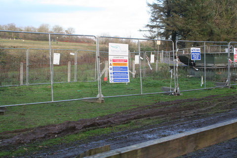
WI pontoons
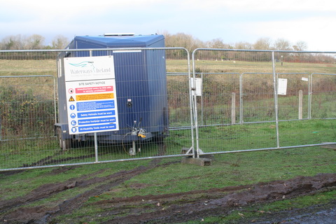
WI canteen
I wondered what was to be done; I noted that a stone at the top of one of the stop-plank grooves under the bridge had been removed (the stone on the far side was removed some time ago).
So I asked Waterways Ireland what was happening. They said:
The works in Clonlara are Flood relief works to protect Errina Lock from catastrophic failure. After the flooding in 2009, during which the dam in Errina Lock was overtopped by approximately 0.5 metres, it was decided to protect it from this happening again.
It has happened before too: in February 1809 the lock was destroyed by floods when heavy snows melted.
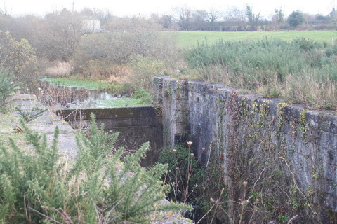
Errina Lock (looking upstream)
I asked WI about the nature of the works. They said:
Stop logs are to be put into the grooves under the bridge forming a dam with the same size opening as that in the concrete dam in Errina Lock. As for the stone which is removed to facilitate the installation of the timbers, this will be replaced once the timbers are in place.
That is good to know.
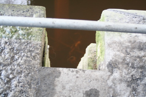
Errina Bridge stop-plank grooves (towing-path side, with uppermost stone removed)
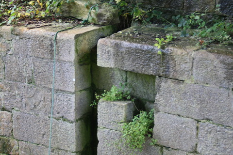
Errina Bridge stop-plank grooves (off side)
An authority on waterways has suggested that the curious shape of the grooves was designed to allow planks to be inserted from boats rather than from land.
Posted in Ashore, Built heritage, Charles Wye Williams, Drainage, Economic activities, Engineering and construction, Extant waterways, Forgotten navigations, Industrial heritage, Ireland, Irish inland waterways vessels, Irish waterways general, Operations, People, Restoration and rebuilding, Scenery, Shannon, Steamers, The cattle trade, The turf trade, Waterways management, Weather
Tagged boats, bridge, canal, Clare, Errina, ESB, floods, flow, groove, Ireland, Killaloe, Limerick, Limerick Navigation, lock, lost, O'Briensbridge, Operations, Plassey, Plassey-Errina Canal, Shannon, stop plank, water level, waterways, Waterways Ireland, weir
Just as Killaloe is to have a new bridge, so too is Limerick. Or perhaps more than one …. This page (on a site whose ownership I do not know) has a map of proposed routes for the proposed Limerick Northern Distributor Road, which is to provide a northern bypass of Limerick. You can read about it on the websites of the promoters, Limerick County Council, Clare County Council and Limerick City Council. You can download stuff. And you will be pleased to hear that there are to be consultations (only not many of them).
This road is to be built in two phases, the first covering the area from west of the city to Parteen and the second from there to the old Dublin road (N7 as was, now demoted to the status of boreen). There are (or were) several options for each section, but the decision to cross the navigation at the Ardnacrusha tailrace, between the power station and the existing bridge, seems to be set in, er, concrete: that is, it seems, where the ESB wants it.

Ardnacrusha and the tailrace seen from the existing bridge at Parteen
The current consultation is about Phase 2, south-east from Parteen. There are several possible routes.
Two of them, B1 and B2, would cross the Shannon downstream of Plassey and the Black Bridge; they would not cross the Plassey–Errina Canal. It would be important to ensure that they did not further damage the towing-path and its artefacts on the Limerick side.

The west bank below Plassey
Four other routes — C1, D1, D2 and E1 — would cross the Plassey–Errina Canal between Gillogue and Wooden Bridge; they would cross the non-navigable Shannon upstream of Plassey, between there and a point just above the confluence of the Mulcair. C1 seems to run very close to Gillogue Lock, although that may be an effect of the scale of the route markings.

Woodenbridge (which isn't)
I am sure that the ESB will look after the interests of the existing navigation (through Ardnacrusha) and that Waterways Ireland will look after those of the former navigation (the river to Plassey and the canal thence to Errina). However, it might be worthwhile lobbing in a comment to TPTB, first to sttress the heritage value of the abandoned navigation and second to suggest that a new road near Plassey might improve rather than diminish access to that area.
One final thought: this new road seems likely to put the final nail in the coffin of the Limerick Tunnel under the Shannon estuary downstream of Limerick. I very much enjoy using the tunnel, but many folk are deterred by the charges and they drive through the city instead — or, worse, cross the Shannon at O’Briensbridge. As a result, revenue is less than expected, so the traffic guarantee mechanism means that the National Roads Authority has to compensate the tunnel operators.
So now that a new, free, presumably fast road is to link the east and west sides of the city, what will happen to the numbers of vehicles using the tunnel and to the taxpayers who are ultimately paying the compensation? They’ll pay more. The tunnel is on a national primary route, so it’s the NRA’s problem, whereas the new bypass is a regional or local route, which is in the hands of the local authorities.
=p-po-
Posted in Ashore, Built heritage, Charles Wye Williams, Economic activities, Engineering and construction, Extant waterways, Forgotten navigations, Industrial heritage, Ireland, Irish waterways general, Natural heritage, Non-waterway, Politics, Scenery, Shannon, The cattle trade, The turf trade, waterways
Tagged boats, bridge, canal, Clare, Errina, ESB, Gillogue, Ireland, Killaloe, Limerick, Limerick tunnel, lock, Lough Derg, Montpelier, O'Briensbridge, Operations, Plassey, road, Shannon, vessels, water level, waterways, Waterways Ireland, Woodenbridge

