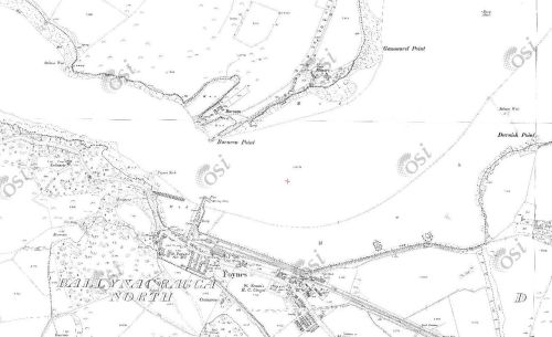
The Shannon Commissioners built or improved seven piers and quays on the Shannon Estuary in the 1840s. In their eleventh and final report, the Commissioners gave the total income at six of them, for quayage, wharfage and cranage, for the year 1849. [Eleventh and Final Report of the Commissioners, Under the Act 2 & 3 Vict c61, for the Improvement of the Navigation of the River Shannon, Ireland; with an Appendix Ordered, by The House of Commons, to be Printed, 3 June 1850 407]
Kilteery £0 4s 10d
Kildysart [Inishmurry] £0 17s 8d
Querrin £7 15s 4d
Saleen £24 0s 10d
Clare [Clarecastle] £67 14s 7d
Kilrush £105 5s 10d
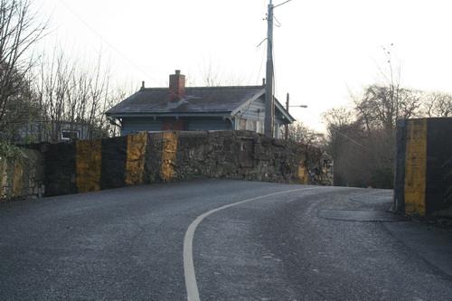
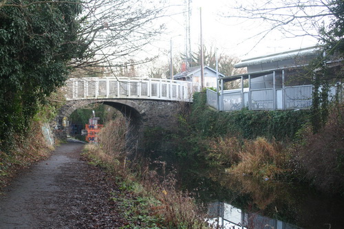
The Shannon Commissioners quay at Querrin
The only two with any significant traffic were the existing ports of Kilrush [which was the only one to have a crane] and Clare. The other four were a waste of money [but are nowadays delightful places to visit].
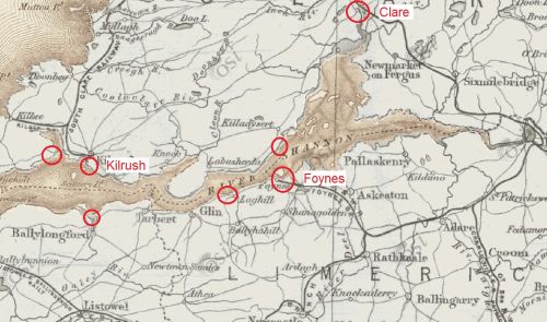
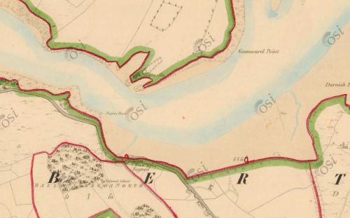
Approximate positions of Commissioners’ quays on the Shannon Estuary (OSI ~1900)
The seventh quay, at Foynes, was not included because work had not been completed: the original plans were replaced by a more elaborate scheme, with a landing wharf, a pier, a slip and a harbour, towards which the proprietor, Lord Monteagle, had subscribed £4250, the largest amount paid by any landowner on the estuary. The Commissioners said:
Foynes Harbour, when complete, will consequently give secure quayage to sea-going vessels at all times of tides, and in fact will be the only port on the Shannon possessing that advantage; all the others, including the quays of Limerick, being dry, or nearly so, at low-water.

Foynes undeveloped (OSI ~1840)
And so indeed it proved to be. Foynes, sheltered by its island to the north, grew as a result of the development of the quays.

Foynes (OSI ~1900)
But Foynes never became quite as important as some folk hoped, in the 1850s, that it would become.
The Irish packet station Commissioners
On 30 August 1850, C E Trevelyan, Assistant Secretary to HM Treasury [who is perhaps best known as the author, with Stafford H Northcote, of the Northcote-Trevelyan Report on the reform of Her Majesty’s Civil Service], wrote a Treasury Minute:
My Lords [of the Treasury] have before them a letter from the Secretary to the Admiralty, dated the 23rd instant, enclosing copies of a letter from the Board of Trade, dated the 8th instant, and an extract from a petition signed by a large number of landed proprietors in Ireland, praying for an inquiry with a view to the adoption as a Packet Station of one of the harbours in Ireland, and suggesting the appointment of a Commission for the above purpose.
Write to the Secretary to the Admiralty, and desire that he will state to the Lords Commissioners that my Lords are pleased to appoint a Commission as recommended by them, consisting of the following gentlemen:—
The Right Hon the Earl Granville, Chairman
The Hon William Cowper, MP and one of the Lords of the Admiralty
Sir James Alexander Gordon KCB, Rear Admiral of the Red, and Lieutenant-Governor of Greenwich Hospital
Sir John Fox Burgoyne KCB, Major-General, and Inspector-General of Fortifications
Captain Stephen Ellerby, one of the Elder Brethren of the Trinity House.
And my Lords desire that three of the said Commissioners form a quorum,
My Lords also concur with the Lords Commissioners of the Admiralty that the above-mentioned petition should be referred to the Commissioners, and that they be instructed to make inquiry —
1st. As to the harbours in Ireland best suited for a Packet Station.
2nd. The advantages and disadvantages of adopting a harbour in Ireland for a Packet Station, so far as regards the trade and other interests of the empire, and to report the evidence to the Admiralty, with such observations as may enable Her Majesty’s Government to form a judgment on the premises.
My Lords request that the Lords Commissioners of the Admiralty will give such further directions as may be required for the meeting of the Commissioners, and for the conduct of their proceedings.
(Signed) C E Trevelyan
[Report of the Commissioners appointed to inquire as to the proposal for an Irish Packet Station. Presented to both Houses of Parliament by Command of Her Majesty. HMSO, London 1851]
The background to this was the transatlantic mail service, for which the UK contract was won by Samuel Cunard in 1839. Steamers left Liverpool every Saturday in summer (April to November) and every second Saturday in winter “alternately via Halifax to Boston and direct to New York”, with return services on Wednesdays: a packet ship was one providing a regular scheduled service, often but not necessarily carring mails. Cunard’s was not the only north Atlantic packet service: the US government had contracts with
- Collins and Brown of New York, for a Liverpool–New York service, fortnightly in summer and monthly in winter
- a line serving Bremen and New York, calling at Southampton
- a third line serving Havre and New York, also calling at Southampton.
The Irish petition, which was concerned only with the UK mails contract, claimed that the total time required, from Liverpool to Halifax or New York, would be shorter if the mails went
- by train from Liverpool to Holyhead [which the Commissioners reckoned would take 4 hours]
- by steamer from Holyhead to Kingstown [6 hours]
- from Dublin by rail to one of several Irish ports
- thence by steamer across the Atlantic.
The Commissioners allowed for time on transits between steamers and railways; they assumed that the railways could operate at 30 miles per hour, which was 5 mph faster than the average at the time. They considered nine possible Irish ports: Cork, Long Island Sound, Berehaven, Crookhaven, Dunmanus Bay, Valentia, Galway and, in the Shannon Estuary, Foynes and Tarbert. Most of those had no rail connection to Dublin, but the Commissioners gave them the benefit of the doubt, assuming that a line would be built to wherever the packet station might be located.
The Commissioners took their job seriously. They circulated queries and received responses from 83 individuals and institutions including shipping firms, naval and coastguard officers, government departments, chambers of commerce, local politicians and officials. They interviewed 32 individuals and deputations, some of them more than once. They considered 36 items of “further documentary evidence” and 53 “further papers, reports &c” and wrote up the whole lot, including two plans (maps).
The Commissioners were not keen on using any port in the west of Ireland:
It appears, from the evidence of the majority of the naval officers to whom we have referred, that the navigation of the west coast of Ireland is dangerous, particularly in the winter. The coast from Mizen Head round to Galway Bay is, in nautical language, “steep-to”; there being 100 fathoms water at 18 to 29 miles off its outlying dangers. It is also subject to fogs and hazy weather, and to frequent heavy gales of wind blowing towards a lee-shore, with high Atlantic seas and very uncertain soundings.
Balancing the time to be saved on the transatlantic crossing and the “nautical qualifications” and resources of each port, the Commissioners said that the two best options were Foynes and Galway. However, the Commissioners did not think any Irish packet station would be a good idea:
We find no reason to conclude that the local and particular advantages resulting from the proposed measure would be so great, or the saving of time so important, as to counterbalance the large additional expense which would be entailed upon the Imperial Revenue, and the evils and inconvenience which would be inflicted on the great body of the mercantile and travelling portion of the community by removing the packets from the place where they were originally established, as being the focus of the commercial transactions of the United Kingdom with the North American continent.
None of the suggested locations for an Irish packet station would save more than 12 hours in a voyage of about 11 days, so the benefit to be gained for the mail service was small. But the principal problem was the effect on the passenger service (and the small amounts of high-value, low-bulk freight which could be sent by steamer). The steamer owners needed the income from both passengers and mails to make their operations pay, and the Irish proposal would have imposed great inconvenience on passengers. Instead of loading themselves and their luggage on the steamer in Liverpool, and unloading in Halifax or New York, passengers would have had to change
- from steamer to railway at Kingstown
- from railway to carriage in Dublin
- from carriage to railway at Kingsbridge or Broadstone
- from railway to carriage at or near the Irish packet station
- possibly from carriage to a small steamer acting as tender
- from tender to transatlantic steamer.
Apart from the inconvenience, the process would have introduced several opportunities for delays.
The Galway and Shannon ports Committee
The Commissioners, then, rejected both Foynes and Galway. But several people in Ireland rejected the Commissioners’ findings, mostly on grounds that were entirely irrelevant. There was a particularly colourful diatribe in the Galway Mercury, and Weekly Connaught Advertiser of 8 May 1852, which lauded Galway’s “glorious expanse of water, deep, and capacious and sheltered as it is, and pronounced by the most competent naval authorities to be one of the finest ports in the whole world”. The decision not to base the packet station there was “a fair specimen of Saxon justice to Ireland”: basing the packet station in Galway would “have the effect, in the course of a few years, of destroying in a great measure the commercial pre-eminence of that country [England, rather than Great Britain or the United Kingdom, it seems], and transferring much of its wealth and its greatness to this island which it hates so cordially, and which for six centuries it has ceased not to plunder and oppress”.
The editor did not, alas, have space to consider such mundane matters as the inconvenience to British passengers of being forced to travel to America via Galway. But the focus of the promoters of an Irish packet station, and especially of the vociferous Galway gang, turned to communication between Ireland and the USA. There were unsuccessful attempts to set up steamship companies; Packet Station Committees were set up [eg Tipperary Free Press 28 January 1852 on Mr Wagstaff and on the Dublin Packet Station Committee; Galway Mercury, and Connaught Weekly Advertiser 31 January 1852 on the Irish and American Steamship Company]; the merchants of Belfast were persuaded that, with a packet station in Galway, American merchants and buyers would visit Ireland and (once a railway link was provided) especially Belfast before visiting England and Scotland [Northern Whig 12 February 1852; Morning Post 16 February 1852; Belfast News-Letter 23 February 1852]. Also in February, the Limerick Packet Station Committee was forced to publish a pained refutation of the recommendations of one James Whiteside, a member of the Dublin committee who was a strong advocate of the Galway proposal [Report of the Dublin Committee Considered, and Mr Whiteside’s Statement Reviewed, with remarks on the relative advantages of the Shannon and Galway Bay published by direction of the Limerick Packet Station Cmmittee, Browne & Nolan, Dublin 1852].
Unfortunately, in the same month, Lord John Russell’s Whig government collapsed and the Earl of Derby set up a minority Conservative government — in which the same James Whiteside, MP for Enniskillen, became Solicitor-General for Ireland. The Tribes of Galway soon descended on the unfortunate Prime Minister, with a “numerous and influential deputation” led by that turbulent priest, the Very Rev Peter Daly, a spiritual father of Monsignor James Horan, determined to wring every penny he could from the temporal power.
The Rt Hon Earl said that improving Galway’s harbour would make sense, in an imperial context, only as a packet station. And because the Irish Packet Station Commissioners had recommended two Irish ports, Foynes and Galway, the first step was to decide between the two of them. Accordingly, the government had decided to appoint three naval officers to visit the two ports, inquire into their relative advantages and report back. He could not commit himself to anything more until he had the report and he was sure that the deputation understood that [Dublin Evening Mail 10 May 1852].
That got Derby through the general election in June, after which he formed another minority government, which lasted only until December. In the meantime, though, the three naval officers — Captains F W Beechey, Henry Smith and James Crawford Caffin — visited Galway and inteviewed witnesses recommended by the Harbour Commissioners and other authorities; they also inspected the port and considered what works might be necessary. They then embarked on HM steam sloop Geyser and sailed to Limerick: they were thus able to see the approaches to both ports. They visited both Foynes and Tarbert on a small steamer and, again, interviewed witnesses. They returned to Dublin by railway.
Their focus was on whether Galway and the Shannon would be accessible at all states of the tide, at all times day or night, and in all weathers. Only with such access could the “greatest regularity and dispatch” be maintained for “steamers of the largest class”. That access was needed whether the ports were to be packet stations or harbours of refuge or both. It was appreciated that both ports would probably need engineering works to be carried out, as well as links to the railways.
On 15 September 1852 the Limerick and Clare Examiner reported Lord Monteagle [former Chancellor of the Exchequer; landlord at Foynes] as saying that the naval officers’ report had been submitted to the Admiralty and that they had preferred Foynes to Galway. However, in its issue of 25 September 1852 the Examiner carried extracts from the report itself, in which the three captains said:
- the Shannon was better than Galway for the “safety and expedition with which a vessel when arriving can be got within the limits of her port” or clear the land on departure
- neither location could provide the required “security and accommodation of the packets, and the convenience for landing and embarking passengers and dispatching the mails”. Facilities could be developed at Galway or at Foynes or Tarbert in the Shannon Estuary; Galway would be much more expensive
- either Galway or the Shannon could act as a harbour of refuge for vessels that had good anchors and cables, but for those without the Shannon provided more safe options
- the west coast of Ireland was “subject to higher seas and worse weather than other parts of the British Islands not so situated, and that weather in which no vessel would be justified in running for a port, does appear to prevail to a greater extent off the western ports of Ireland than at other ports”, which would mean that the “greatest regularity and dispatch” could not be assured
- accordingly, neither Galway nor the Shannon was suitable as a packet station.
The report is Galway and Shannon Ports: Return to an Order of the Honourable The House of Commons dated 31 March 1859 for a copy of the instructions of the 11th day of June 1852 from the Admiralty to the Committee appointed to inquire into the suitableness and capabilities of the Ports of Galway and of the Shannon for a Transatlantic Packet Station, in connexion with a harbour of refuge … Ordered, by The House of Commons, to be Printed 19 April 1859 257.
Only the Cork [Cork Examiner 27 September 1852] and Belfast papers [Belfast Mercantile Register and Weekly Advertiser 28 September 1852] were pleased, seeing an opportunity … as did the Earl of Mayo, who wanted the packet station set up in Blacksod Bay.
The packet station schemes
It seems that the packet station enthusiasts wanted
- the government to pay for whatever harbour and other works were needed
- the government to designate the chosen port as a packet station for the mails
- one or other of the private-sector contractors to be forced to use that station
- the Post Office to cope with the many links in the chain from the Atlantic through Galway and Dublin to Britain, each link providing an opportunity for things to go wrong — and all of them on the critical path.
There do not seem to have been any serious attempts to quantify the likely passenger traffic: at that time, as in the early days of air travel, only small numbers of passengers could be carried and high fares were required. Furthermore, only for small, high-value or perishable freight was the extra cost of steam travel worth paying: for anything else, sail was cheaper. But the enthusiasts do not seem to have been willing or able (at least at that time) to come up with the money required to set up their own steam shipping company: the Dublin committee had decided that it would be too risky an investment given the competition from established operators at British ports.
The whole thing sounds like the mad attempt to get a canal to Clones.
The Department of Communications, Climate Action & Environment
But the politicians have not yet finished with Foynes. According to the Limerick Leader of 10 November 2016,
Foynes in line to be US transit hub, says minister
Hundreds of jobs could be created at port
I can’t find any mention of this on the website of the Department of Communications, Climate Action & Environment, so I am unable to check the newspaper report. It begins:
FOYNES Port is poised to become a major European link with the US in the wake of Brexit, in a new Government proposal that could create hundreds of local jobs.
Now, we must immediately eliminate the exaggeration that might be the fault of the minister or the journalist: “in line to be” and “poised to become” might suggest that there is some plan or perhaps even some agreement between the USA and some undefined European body, whereas all we have, it seems, is a bright idea, the first phase of the underpants gnomes’ business plan.
It seems that there might be a demand for the use of facilities at Foynes for one or more of these reasons:
- Brexit (which, of course, means Brexit)
- “US pre-clearance for ships crossing the Atlantic”
- congestion at Rotterdam
- Foynes as a transit point for freight to and from North America.
This mishmash of unconnected ideas may or may not be the minister’s fault. Let’s see if we can make sense of it.
Brexit
According to the article
“Our second biggest export destination is the USA. From a Brexit point of view this is an opportunity to attract industries from right across Europe that are exporting into the US,” said Minister Naughten.
“The reality is that post-Brexit exports into the UK are going to be put under pressure, so this is an opportunity to make a new market and make it far more efficient for the export of goods.”
A ‘hard Brexit’ could result in EU borders, which would increase costs for freight companies shipping out of Britain into Europe. This proposal means that Foynes could become a more attractive destination for these companies to ship from.
The first paragraph is nonsense. Existing trade with the US is irrelevant to the proposal. As for the “opportunity to attract industries from right across Europe”, their ability to export to the USA is entirely unaffected by Brexit, unless that nice Mr Trump arranges something really insane with Ambassador at Large Farage. If you’re exporting widgets from Dusseldorf to the USA, why would Brexit cause you to route them through Foynes?
The second paragraph is no better.
The reality is that post-Brexit exports into the UK are going to be put under pressure, so this is an opportunity to make a new market and make it far more efficient for the export of goods.
Whose exports are we talking about? What new market? Far more efficient than what?
The third paragraph is confusing.
A ‘hard Brexit’ could result in EU borders, which would increase costs for freight companies shipping out of Britain into Europe. This proposal means that Foynes could become a more attractive destination for these companies to ship from.
There are, we are told, freight companies shipping out of Britain into Europe. I don’t know why we’re discussing freight companies rather than manufacturers or distributors [the ultimate emptors, who will pay the freight companies for the cost or inconvenience]. But anyway, these companies are shipping “out of Britain into Europe”, so we can assume that the goods start in Britain. If they are to get to Foynes, they still have to be shipped out of Britain into an EU member state, ie Ireland. So instead of going straight to Calais, say, they get shipped to the far side of Ireland and then back to the continent. How does this make the freight companies’ lives easier? Why would the UK/Ireland border be any less hard, or less bureaucratic, than the UK/France?
US pre-clearance
This seems to deal with a separate set of exporters: presumably those remaining in the EU and exporting to the USA. The idea seems to be that they will send their stuff to Foynes, where
“Freight would come into Foynes, get scanned there, get certified, and land in New York and would be the same as an internal shipment.”
According to the Department, Mr Naughten met with the US Ambassador to Ireland Kevin O’Malley and asked him to support the proposal, which would involve US custom official staff being based in Foynes to give full pre-clearance.
I can see that this might create a job or two in Foynes for US customs officials, and perhaps some local admin support. But I see two possible problems. The first is that this might count as an international trade agreement, and Ireland may not be entitled to make its own agreements outside the EU system. I do not, however, know whether that it so. But the second problem seems to me to be more serious: it is that the idea cannot be copyrighted or protected. There would be nothing to stop any other port applying to set up a similar arrangement, getting the benefits of US pre-clearance without the cost and loss of time in sending ships via Foynes.
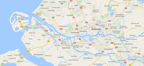
Congestion at Rotterdam
I do not know whether there is congestion at Rotterdam, but if the volume of world trade is falling that problem might solve itself. Nonetheless, it is useful to keep things in proportion. Here is a map showing the whole of the Shannon Estuary. I’ve circled Foynes.

Shannon Estuary (Imagery copyright 2016 DigitalGlobe, map data copyright 2016 Google)
And here, on the same scale, is Rotterdam. All those bits that look artificial, too straight to be natural, are docks. You can fly over it yourself here [short URL].

Rotterdam (Imagery copyright 2016 DigitalGlobe, map data copyright 2016 Google)
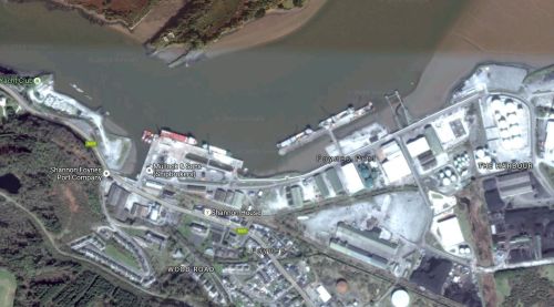
Here’s Foynes in close-up.

Foynes (Imagery copyright 2016 DigitalGlobe, map data copyright 2016 Google)
I don’t think much of the overflow from Rotterdam will fit at Foynes. Of course there is lots of space elsewhere in the estuary, but it can’t be used: it’s reserved for the tweetie-birds.
That may be a bit of an exaggeration, as you can read here, but the Shannon Estuary isn’t going to get to even 1% of Rotterdam’s capacity.
Foynes as a transit point
I don’t know what that means. Maybe it’s just attaching another buzzword to the pre-clearance idea. If, though, it involves any sort of transhipment, forget it.
Solutions in search of problems
The Shannon Estuary may contain more wasted public-sector investment than any other estuary in Ireland, from the Wellesley [sorry: Sarsfield] Bridge through the Shannon Commissioners’ piers to the minor railways. [As if three loss-making railway lines — to Galway, Ballybrophy and Waterford — weren’t enough, there is a campaign to restore a fourth, to Foynes.]
Both the Shannon Commissioners’ piers and the packet station campaign sought public money to build facilities in the hope that they would attract private investment. In those cases, and with this present campaign, it might be better to wait for a private-sector investor to put money on the table first.