Category Archives: Scenery

Chains at the Black Bridge

It seems that the city edition of the Limerick Leader dated Saturday May 16 2015 carries a story saying that funding has been approved for the repair of the Black Bridge at Plassey. I can’t find the story on the Leader‘s website and I can’t find anything about it anywhere else [there is a limit to the amount of my life I am willing to spend trying to find anything on the Limerick Council website] except on the Leader‘s FaceTweet page, where I can expand the city edition front page.

There is a photo of several councillors, which of course is wonderful: no day is wasted if it offers an opportunity of looking at a photo of local councillors, especially important ones with chains.

From what I can read of the text, it seems that “councillors in City East” [which is not one of the Limerick districts listed here] are willing to spend €50,000 “to start work to make the walkway safe again”. And they hope that Clare County Council, the University of Limerick and Waterways Ireland will “also row in behind the project”.

Now, half a loaf is better than no bread, and €50,000 is better than a poke in the eye from a blind horse, but it’s not going to go very far towards the cost of repairing the Black Bridge. I don’t known whether it would even cover the cost of a full survey.

I’m sure that Waterways Ireland would be delighted to help, if the Department of Fairytales hadn’t raided its coffers to pay for Saunderson’s Sheugh. I have reason to believe that the university was willing to help — and that Clare County Council was not. I submitted a Freedom of Information request to the university, asking it for [recent] records relating to the Black Bridge. The university gave me three extracts from meetings of the Limerick Smarter Travel Steering Group:

9 January 2013
Funding not in place for Black Bridge

21 November 2013
Black Bridge: UL indicated that funding may be available from UL. LST [Limerick Smarter Travel] has indicated funding in the order of €100,000. UL may be able to mach [sic] this. Request for funding to be made formally to UL by LCCC and to include surveys and reports on bridge to date.

18 September 2014
RR said UL have set aside €100,000 towards Black bridge refurbishment but will need matched funding from LA [presumably local authority]. Black bridge will require a detailed study to identify what repair work will need to be carried out, also an AA study will be required, and proper consents from ABP [An Bord Pleanála?]. Funding currently not available from LA.
PON spoke to Clare Co Co. No funding available from them.
PC Department will not fund a pedestrian bridge.
RR can we look for alternative funding options, UL will ring fence for the moment.

An AA study is, I think, an Appropriate Assessment, a sort of employment creation scheme for bird-watchers who can read European directives [and sooner them than me].

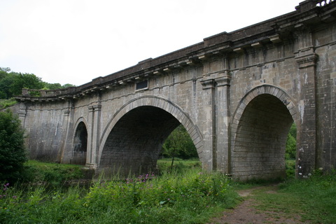
The point to be remembered here is that Limerick County Council leased the bridge and undertook to keep it in repair; there is no obligation on Waterways Ireland, Clare County Council or the University of Limerick to spend a penny on it. The two parties on whom lies the responsibility for repairing the bridge are the Limerick Council and the Department of Finance, which latter has the power, under the lease, to do the work and charge it to the council. That would be a better use of its time and money than an unnecessary and intrusive footbridge in the middle of Limerick.

River Suir

My spies tell me that the RTE television programme Nationwide, to be broadcast on Wednesday 13 May 2015 at 7.00pm, will include some material about the River Suir and perhaps some footage of a former tug-barge, the Knocknagow, that plied thereon.

Hurrah for the red, white and orange

Colour discrimination seems to be rampant in Ireland. Of the sets of colours [red, white and blue] and [green, white and orange], there is Official Endorsement of two, green and blue, while red, white and orange are ignored. Even the North/South Ministerial Council has got in on the act, with a whole page on its website about greenways and blueways. They must have been overdosing on the Erne flag. Their page is a list of links, sort of plonked there without context or explanation, but there’s probably some hands-across-the-borderism or something going on.

I read in the Guardian today of a proposal for a greenway on the former railway line between Roscrea and Portumna via Birr. And a jolly good thing too, but how many greenways and blueways can one small island accommodate? How thinly will the tourists be spread? And what about those of us who hate walking, cycling, kayaking and other such energetic pursuits?

Races on Lough Erne

To the Editor of the Erne Packet

Me Editor — The stir visible amongst the seamen of the Lake, assures a most interesting contest. Four new boats are to enter the lists — their prowess will best prove the merit of those which have on former occasions been exhibited.

To the amateur, the scene cannot fail of proving most interesting, as well from the unrivalled beauty of the sailing ground, as from the superiority of the boats, some of which, built on the Thames, are considered to be superior to any other vessels of any size, for lake sailing.

The mariners of Donegal Bay will not, it is to be hoped, sleep on their oars; if rumour is to be credited, they are not to yield the palm so easily as they did last year. Four boats besides those already mentioned, are reported to be in readiness to invade the lake, from the sea, to assert the superiority of the Donegalian over his fresh-water competitor.

Some experiments are to be tried upon scientific principles,where lightness of draught of water, and form, altogether differing from what, for centuries, has been in use, are to be put into competition with bulk and beam. The well established speed of the Lough Erne cot is also to be tried, a boat being in preparation; these rivals to be pulled by Gentlemen of the lake. Great confidence is expressed by the owners, and any money for hands with good beam and bottom. NB — Dandies not admitted.

To cheer the toils of the seamen, two Balls are in contemplation, where all the rank and fashion of a wide extended country have engaged to attend. A very distinguished party from London, òn a visit to the Lakes and Bundoran, will also be present, and gratify the eye, as they have already done the mind’s eye of most of us.

Besides the beauty of the Lakes, much speculation exists to account for their visit, whether an examination into the minerals and collieries of the neighbourhood, or the general capabilities of Lough Erne, an extension of the navigation, and perhaps a decision of a question which has long barred up our Lake; the choice between a canal to Lough Neagh and Belfast, or one from Ballyshannon. In giving information to these sagacious explorers, Gentlemen will do well to bear in mind, that their evidence should be divested of any private favour, for should it be found to contain more affinity for party purposes than the general object, the benefit of the country, it will instantly, and perhaps not civilly, be rejected as unfit matter to enter into such an important digest.

NOTUS

Enniskillen Chronicle and Erne Packet
12 August 1824

The K&A in slow time

The Dundas aqueduct

The Dundas aqueduct

There is a television station or channel called BBC 4. On Tuesday next, 5 May 2015, it will broadcast

A two-hour, real-time canal boat journey down one of Britain’s most historic waterways, the Kennet and Avon Canal, from Top Lock in Bath to the Dundas Aqueduct. Using an uninterrupted single shot, the film is a rich and absorbing antidote to the frenetic pace and white noise of modern life.

More info here. I do not know whether folk outwith HM Realm can watch the programme on television or on tinterweb.

Waterside Belturbet

Here is a small amount of information about Belturbet and some of its industrial heritage. The photos were taken on a brief visit in July 2011.

Was the Brickey a navigation?

The Brickey is a small river that flows into Dungarvan Bay. Small boats used its lower, tidal reaches, but in the eighteenth century there was a proposal to link the Brickey to the Finisk, another small river that flows into the Blackwater south of Cappoquin.

Waterford County Museum, and others, believe that work began on that project in the mid nineteenth century and that a driveable track along the south bank of a stretch of the river was built as a towpath.

I have visited the river and looked online for further information; my conclusions (with maps and photographs) are here. However, I would welcome further information.

Blueways

Longford Tourism and Waterways Ireland are holding an information meeting about Blueways in Longford tomorrow. It’s in the Backstage Theatre on Tuesday 24 March 2015 at 7.00pm. The blurb reads:

Are you an activity provider, accommodation provider, walker, boater, canoeist, outdoor enthusiasts?

Longford Tourism, in conjunction with Waterways Ireland is delighted to invite you to a Public Information Meeting regarding exciting new recreation and tourism products called Blueways.

Blueways are a series of innovative, safe and easy to use water and land-based trails. These provide for guided and unguided paddling, walking and cycling. Visitors can opt to paddle along the Shannon Blueway, on a 10km looped trail along the Camlin and Shannon Rivers, while the Royal Blueway provides 16km of off road walking and cycling from Cloondara to Longford Town.

To celebrate this exciting trails development, Longford Tourism will host the inaugural Longford Blueways Festival in April. So, come along and hear how you can get involved. All are welcome to attend.

I wish them well and I hope this initiative works. I think that the Blueways are more likely to be successful than any attempted revival of the cruiser-hire business (although I’d like that to work too). However, I would like to learn more about the Blueways business model (if that’s the right term). Who has to invest how much and who gets what returns? Clearly, Waterways Ireland spends money up front, but far less (I presume) than (say) canal restoration would require. But are there viable businesses, or at least viable supplementary income-generating activities, for small local service providers? How do they reach overseas markets? Or is the focus on domestic markets?

One point that strikes me is that Blueways allow for more interaction between tourists and locals: something that used to be a strength of the Irish tourism offering (I’m trying to keep up with modern marketing jargon here) until we decided we were too busy being rich and successful to waste time chatting to tourists (or, if you prefer, providing unpaid support services to the tourism industry). Indeed we felt that even paid employment in tourist enterprises was beneath us: we could get nice people from overseas to do that work instead. Did we, I wonder, hollow out Ireland, removing the Irishness, the distinctiveness (whatever it was) from the tourist experience?

If so, the Blueways’ opportunities for interaction with small-scale and local enterprises might put them back again. There are difficulties in making a living from small-scale operations, but there are benefits too. And the Blueways might tap into other local, small-scale developments: for instance, the recent startling growth in the number of craft breweries. The Lough Allen and Longford Blueways each have a local brewery — St Mel’s in Longford and Carrig in Drumshanbo — and the products of at least one other brewery, Co Roscommon’s Black Donkey, are available on the North Shannon. Maybe, now that KMcG is back, “Places to find good beer” might be added to places to stay, eat and go on the Blueways website.

A Blueway is defined there as

a recreational water activity trail that is developed for use by non-motorised water activity enthusiasts. It is defined by trail heads, put in and take out points and readily available trail information. Blueways can be developed on canals, rivers, lakes or along the coast and can incorporate other associated land base​d trails adjacent to the water trail.

So what about a Blueway for Lough Oughter, with sailing, canoeing and camping?

[h/t Carthach O’Maonaigh]

Politician asks sensible question shock

The invaluable KildareStreet.com tells us of this written Dáil question and answer on 4 February 2015:

Martin Heydon [FG, Kildare South]: To ask the Minister for Arts, Heritage and the Gaeltacht if her attention has been drawn to concerns regarding the lack of dredging on the lateral canals of the River Barrow and overgrown vegetation which is making navigation difficult; her plans to improve this situation; and if she will make a statement on the matter.

The lateral canal at Ardree on the Barrow

The lateral canal at Ardree on the Barrow [OSI ~1840]

Heather Humphreys [FG, Clones Sheugh]: I am advised by Waterways Ireland that, as the Barrow Navigation is wholly situated within the River Barrow and River Nore Special Area of Conservation (SAC), due regard must be given to the provisions of the EC (Birds and Natural Habitats) Regulations 2011. These require a rigorous assessment to be carried out to assess the impacts of any work on the protected species and habitats, prior to any works being undertaken.

If the impacts cannot be screened out and a Stage II assessment is required, a full planning application must be made. In addition, the Fisheries Consolidation Act 1959 (as amended) prohibits any in-stream works, such as dredging, during the spawning season from October to June.

I am informed by Waterways Ireland that dredging on the lateral canals of the Barrow Navigation was historically done during the winter months but that this is not now possible. However, Waterways Ireland is working with Inland Fisheries Ireland to formulate procedures which would allow work to be carried out in accordance with the relevant legislation. In addition, Waterways Ireland is continuing to work with all relevant agencies to ensure that as much work as possible is carried out on the Barrow within the time constraints which exist.

I have been assured by Waterways Ireland that it remains fully committed to the development of the Barrow Navigation in line with its statutory remit.

This question produced useful information, whereas some TDs seem to ask questions only as a way of assuring their constituents of their undying love and devotion. See, for instance, Brendan Smith, who has asked the same question at least three times.

Note that the short dredging season presumably applies to other rivers that are within SACs, such as the River Shannon at Plassey.

My OSI logo and permit number for website

Killaloe Regatta

If you enjoyed the account of the 1851 cot race at Plassey, you might also like to read about the 1850 regatta at Killaloe.