Category Archives: Sea

The Southern Star

The Southern Star is West Cork’s indispensable source of news and information. I don’t know whether its masthead still proclaims that it incorporates the Skibbereen Eagle, or whether, in the print edition, its news from Bandon is still headed “Bandon Brieflets”, but it is — as we would expect — keeping up with digital technology with a website, a FaceBook thingie and a napp.

It reports today on another “trial flight” by what it terms “A newly formed company, Harbour Flights”, which I wrote about here. The aircraft shown in the photo is EI-CFP [which is registered, incidentally, as a land aeroplane [.xls]], so Harbour Flights does not seem to have acquired a larger plane — or the use of one: the register shows that EI-CFP is owned by Kieran A O’Connor, not by Harbour Flights.

Being ignorant of aviation matters, I don’t know what constitutes a trial flight — or how it is to be distinguished from a promotional flight.

I note a slight contradiction in the Southern Star‘s report:

The company […] has taken five years to grow from its initial concept to become fully operational last July. […]

When it becomes fully operational, Mr Heaps estimated that the company could create up to 50 new Irish jobs […].

So is it, or is it not, “fully operational”? I am confused.


Newry and Narrow Water

I wrote a few days ago about the proposed bridge across Carlingford Lough at Narrowwater (or Narrow Water). I was reminded of that today on reading a debate, held in the Northern Ireland Assembly on 30 September 2013, about a proposed Newry Southern Relief Road [thanks to theyworkforyou.com].

Apart from an admittedly minor mistake made by a Sinn Féin MLA about the Newry Canal (first summit-level canal, not “oldest inland waterway” in These Islands), the debate was remarkable for its demonstration of cross-party agreement: not so much on the desirability of public works (a desideratum of Irish politicians since the eighteenth century) as on the irrelevance of the Narrowwater bridge. Jim Wells [DUP] said:

There has also been some progress on the Narrow Water bridge project, although we do not know exactly where we stand. First, that bridge is far from certain, and, secondly, even if it were built, it would not relieve much of the traffic that we are dealing with. It would certainly not relieve the large number of juggernauts coming through from Warrenpoint harbour.

Sean Rogers [SDLP] said:

Narrow Water bridge is merely a tourist bridge, but the relief road would take heavy goods vehicles off the streets of Newry, reduce traffic congestion and attract even more shoppers to the city. Heavy goods vehicles would also have a direct route to Warrenpoint port, increasing trade in the port area.

And the other contributors to the debate did not mention it, which suggests to me that it is seen as irrelevant to the traffic problems of Warrenpoint and of Newry.

The Minister for Regional Development, Danny Kennedy [UUP], gave a lengthy response to the debate, including this point:

A more detailed technical investigation of the specific options for crossing the Newry canal was also recommended, given the sensitive nature of this important heritage feature. It is expected to require at least the provision of a bascule, or lifting bridge, to allow the passage of tall ships on the canal. The width of the Victoria lock already limits the size of ship that can enter the canal and it is expected that any bridge would maintain a navigation channel that matches the width of the sea lock. My Department will continue to consult with NIEA on how the impact of the proposal on the canal might be mitigated and an appropriate design developed.

And it seems that one of the areas being considered for the road is Fathom, which is where the Victoria Lock is. It is a short distance north (and upstream) of the border.

It must surely be unlikely that there will be two crossings of Carlingford or the Newry River [and canal] within a few miles of each other. But if one option, the Newry Southern Relief Road, helps to relieve Newry and Warrenpoint traffic and the other, the Narrowwater bridge, doesn’t do so, then the first option would seem to be the rational choice.

Although I wouldn’t bother providing for “tall ships”.


Hands across the water

Another bit of northsouthery seems to be crumbling around its proponents’ ears, according to a report in today’s Irish Times [which will disappear behind a paywall at some stage]. It seems that, in July, TPTB approved the spending of €18.3 million on a bridge at Narrowwater [or Narrow Water], upstream of Warrenpoint and downstream of Newry (and of Victoria Lock). However,

The leading bid has costed the bridge at over €30 million […].

I presume that inflation does not account for the 66% increase but I am surprised that the proponents’ estimate was so far off. Perhaps omitting the opening span (intended to cater for the small number of tall vessels that use the Ship Canal to visit Newry) would save a few quid.

There is a discussion of the bridge project here and some useful information here; there isn’t here, although you might expect it.

It is certainly true that anyone wanting to drive from, say, Greenore or Carlingford to, say, Kilkeel or even Warrenpoint faces a long drive around Carlingford Lough. What is not clear to me is whether very many people want to do that: I haven’t investigated the matter, so I don’t know, but the main north/south traffic passes to the west and there are crossings at Newry.

A ferry service might be cheaper; it might also allow the real strength of demand to be gauged. Ferry terminals might be constructed by the local authorities and leased to an operating company.

And the service would probably be more useful than the Clones Sheugh: I see that yet another member of Sinn Féin got to ask about that in the Dáil recently, as did a Fianna Fáil chap from the area; they elicited the standard answer. The minister may be hoping that the cost estimates for the sheugh are more robust than those for the Narrowwater bridge.

Eel update

Thanks to KildareStreet.ie for drawing our attention to a useful update, in a Dáil written answer, on the state of Ireland’s eels and the eel management plan.

Shannon passage times 1838

Estuary

Kilrush to Limerick 4 hours

Tarbert to Limerick 3 hours

Clare[castle] to Limerick 3.5 hours

Limerick Navigation

Limerick to Killaloe:

  • iron passenger boat 2.5 hours
  • timber passenger boat 3.5 hours
  • trade boat 6 hours.

Shannon

Killaloe to Portumna:

  • passenger steamer 6 hours
  • steamer towing lumber boats 8 hours.

Portumna to Shannon Harbour:

  • 6 hours.

Shannon Harbour to Athlone:

  • 8 hours.

Source: Railway Commissioners second report Appendix B No 6.

A wet winter?

Today’s Irish Times reports on yesterday’s launch of a report called Ireland’s climate: the road ahead [92.9 Mb 103 page PDF here]. The report predicts:

  • Daytime summer temperatures to rise by up to 2°C
  • Lowest winter night-time temperatures to rise by 2-3°C
  • Milder winters to reduce cold-related mortality rates
  • Wetter winters and drier summers
  • Increase in frequency of heavy precipitation event.

Chapter 10 “Climate change and catchment hydrology” covers river flows.

Met Éireann’s report on summer 2013 [2 page PDF] is available here; rainfall was down [on the 1981–2010 average] at all stations except Valentia; temperature was up everywhere and so was sunshine. So perhaps we’ll have a wet winter to look forward to.

Landing pills

They had two of them on the Slaney.

Oh no! It’s ITLAP Day

That’s International Talk Like a Pirate Day.

Canal carrying 1846: Dublin to Waterford

Lowtown is at the western end of the summit level of the Grand Canal; it thus has some claim to be the highest point on the canal. It is close to the village of Robertstown in County Kildare.

Lowtown is also the site of the junction between the main (Dublin to Shannon) line of the Grand Canal and its most important branch, the Barrow Line.
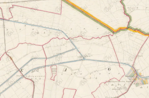
Lowtown (OSI ~1840)

Lowtown (OSI ~1840)

The main line from Dublin comes in from near the bottom right and exits near the top left. The two cuts leaving near the bottom left are the Old and New Barrow Lines, which join together just off the map. The Barrow Line runs to Athy, in south County Kildare, from which the Barrow [river] Navigation runs to the tidal lock at St Mullins, downstream of Graiguenamanagh.

The River Nore joins the Barrow a litle further downstream; the Nore is navigable on the tide upstream to Inistiogue. The combined rivers flow south through the port of New Ross and eventually join the estuary of the River Suir. Turning right at that point takes you up the Suir to Waterford, Carrick-on-Suir and Clonmel. Thus the Barrow Line, from Lowtown, forms an inland waterway link between Dublin and some towns along the Barrow, Nore and Suir.

Isaac Slater’s Directory[i] of 1846 lists those carrying goods on inland waterways. There is a long list for Dublin; entries for other towns list those providing local services. There are some conflicts between the lists (see below).

The map below shows those carrying on the Barrow Line of the Grand Canal and on the rivers Barrow, Nore and Suir. Each carrier is assigned a colour, which is used to frame the name of each place served by that carrier. Some towns (Mountmellick, Carrick-on-Suir, Clonmel) are off the map, further to the west. Note that the map is from the 25″ Ordnance Survey map of around 1900 rather than the 6″ of around 1840: I used it because it was clearer, but it shows features (eg railway lines) that were not present in 1846.

Click on the map to get a slightly larger version.

Dublin to Waterford: inland waterway traders 1846 (OSI)

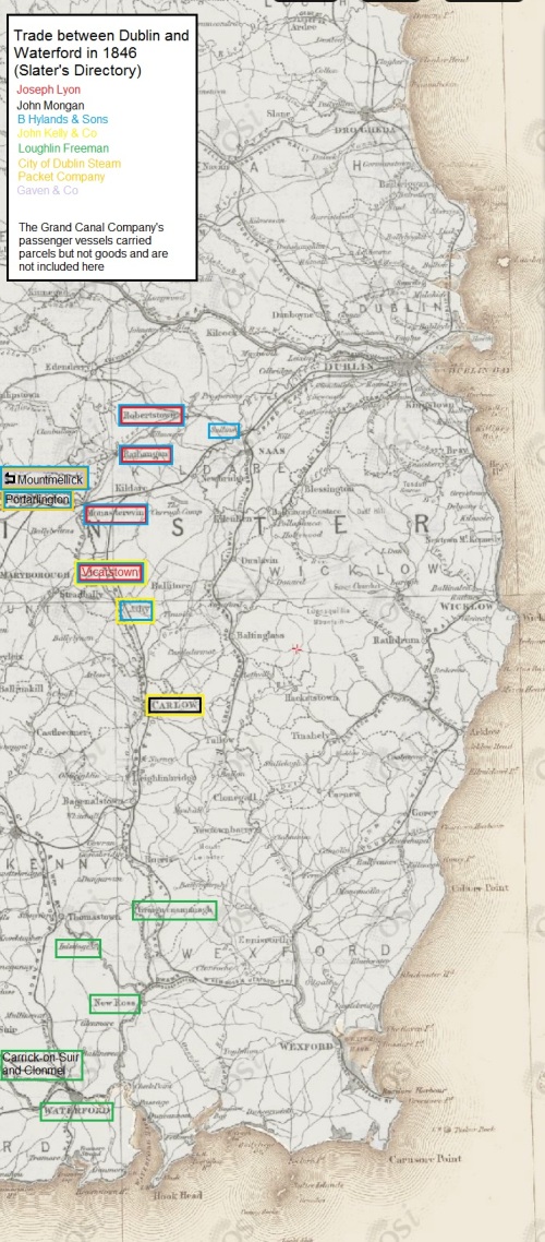
Dublin to Waterford: inland waterway carriers 1846 (OSI)

Notes

All but one of the carriers are shown as having Dublin premises at Grand Canal Harbour, James Street. The exception is Gaven & Co, which is mentioned only in the Mountmellick entry.

I have not included the Grand Canal Company’s passenger-carrying boats, which carried parcels but not goods.

The City of Dublin Steam Packet Company entry for Dublin does not include Portarlington and Mountmellick amongst the towns served but the entry for Mountmellick says that the company’s boats leave for Dublin every Tuesday and Friday (its agent being John White) while that for Portarlington says they leave weekly. Boats from Mountmellick had to pass through Portarlington as well as Monastereven and other towns en route to Dublin.

Similarly, the entry for Mountmellick says that the Hylands boats leave there every other day while that for Portarlington says that they pass through weekly.

There is a page missing from the electronic copy of the directory that I consulted so the entry for Monastereven is incomplete.

The entry for Carlow says

To DUBLIN, and also to [New] ROSS, Boats depart, at uncertain periods, from the Wharfs of Lawrence and James Kelly, the Quay.

It does not say whether Lawrence and James Kelly owned any boats. They may have had boats but used them only for their own goods.

The entry for Mountmellick says “Bryan Hyland” rather than “B Hylands”.

The entry for Mountmellick includes the only mention I have found of Gaven & Co’s boats (James Waldron, agent).

The entry for Rathangan says

There are Boats for the conveyance of Goods, but no fixed period of departure.

Thomas Berry & Co, the most important carrier on the Grand Canal, did not venture south of Lowtown.

More

As far as I know, little has been written about the carrying companies, especially those of the nineteenth century. I would be glad to hear from anyone who can correct, supplement or comment on this information.


[i] I Slater’s National Commercial Directory of Ireland: including, in addition to the trades’ lists, alphabetical directories of Dublin, Belfast, Cork and Limerick. To which are added, classified directories of the important English towns of Manchester, Liverpool, Birmingham, Sheffield, Leeds and Bristol; and, in Scotland, those of Glasgow and Paisley. Embellished with a large new map of Ireland, faithfully depicting the lines of railways in operation or in progress, engraved on steel. I Slater, Manchester, 1846

My OSI logo and permit number for website

Shannon traffic to June 2013

The figures for Shannon lock passages to the end of June 2013 are now available. The decline continues, though perhaps more slowly.

Shannon traffic Jan to June percent

Shannon lock and bridge passages January to June as percentages of the 2003 number

The usual caveats apply: the underlying figures (kindly supplied by Waterways Ireland) do not record total waterways usage because, for instance, sailing, fishing or waterskiing on lakes or river stretches, which did not involve a passage through a lock or Portumna Bridge, would not be recorded. The passage records are our only consistent long-term indicator of usage of the Shannon but they would not show, for instance, a change in the balance of types of activities from those in larger cruising boats to those in smaller (sailing, fishing, waterskiing) boats. It is quite possible, therefore, that overall usage might be increasing while long-distance cruising was declining.

Shannon traffic Jan to June private

Shannon lock and bridge passages by private boats January to June

As it happens, the figures show a small increase over 2012 in passages by private boats. I suspect that July’s warm weather will spur a further increase.

Folk living in Ireland, whether owners or prospective hirers, are likely to be able to react quickly to better (or worse) weather by doing more (or less) boating; folk living abroad may be less able to change their holiday plans. Accordingly, July’s weather might (I’m speculating here) mean an increase in passages by private boats and by boats hired by Irish residents; it might not lead to an increase in hiring from abroad.

Traffic in hired boats continued to decline in June.

Shannon traffic Jan to June hire

Shannon lock and bridge passages by hired boats January to June

That decline outweighed the small increase in private traffic, leading to an overall decline in the first six months as compared with the same period in 2012, which itself continued the pattern set in 2007.

Shannon traffic Jan to June all

Shannon lock and bridge passages by all boats January to June

I wondered whether the figures might show any change in the geographical distribution of activity. WI’s reports don’t show separate figures for private and hired boats for the individual locks, but it seems to me that the hire business is becoming more concentrated on northern waters, from Lough Ree upwards. If that is so, then there might be an increase in the proportion of passages through the northern locks, from Tarmonbarry upwards, and a decrease in the proportion passing through Portumna Bridge and Meelick (Victoria) Lock.

I put the WI reporting stations in four groups:

  • Portumna + Meelick
  • Athlone
  • Tarmonbarry, Clondra, Roosky, Jamestown (Albert), Knockvicar (Clarendon)
  • the also-rans: the three locks leading to Lough Allen, Pollboy leading to Ballinasloe, the Limerick sea-lock (Sarsfield).

The figures suggest that the distribution is indeed changing, but gradually rather than dramatically. Athlone’s figures are pretty steady, the outliers are declining slightly and Portumna + Meelick are declining a bit more; the northern locks (Tarmonbarry to Knockvicar) are taking the gains. Comments or alternative interpretations welcome.

Change by region

Lock passages by group

The figures for 2013 are for the six months January to June; those for other years are for twelve months.

The locks could of course be grouped in other ways, and I may try some of them in future months.