A new piece by The Antiquarian about very early works on the River Hind.
As well as the link here, I have put a permanent link from my own page on the Hind.
So there you are, en route from Kingsbridge railway station in Dublin to Westport in Co Mayo. Or, as it might be, from Westport to Dublin. Either way, the journey takes at least three hours.
What you would like, of course, is to lengthen the journey by making a little stop along the way. In particular, you would like to stop in Roscommon to see the Church of the Sacred Heart. You could get off your train, visit the church and then catch the next train. You might even be able to do the same in Castlerea.
That is according to Senator Terry Leyden of Fianna Fáil. Now that the Shannon stopover, which hijacked transatlantic passengers en route to Dublin, is no more, the good Senator proposes an equivalent for the railways.
Posted in Ashore, Built heritage, Ireland, Modern matters, Passenger traffic, People, Rail
Tagged Kingsbridge, railway, Roscommon, Terry Leyden, Westport
Some folk have been sailing on the Thames in a boat made of cardboard.
Over two hundred years ago, Isaac Weld navigated the lakes of Killarney in a boat made of brown paper:
Whilst engaged in illustrating the scenery of that beautiful locality, Mr Weld derived additional pleasure from the occupation, in introducing a young and amiable wife to scenes so familiar to himself. To facilitate their rambles, and profiting by his Canadian adventures and his skill as a “voyageur“, he constructed with his own hands the model of an Indian canoe. In the absence, however, of birch bark, he had recourse to successive layers of stout brown paper, creating a sort of papier-maché boat, sufficiently roomy for two. In this paper skiff he actually had the hardihood to intrust himself and fair companion in sundry adventurous voyages on the Lakes.
That is from “Mr Foot’s Memoir of the late Isaac Weld, Esq” in The Journal of the Royal Dublin Society Volume I 1856–57 Hodges, Smith & Co, Dublin 1858. Wikipedia offers a shorter account of the life of the remarkable Mr Weld. His Statistical Survey of the County of Roscommon, Royal Dublin Society 1832, is an invaluable source of information about the Shannon and the Royal Canal, but Mr Weld is also notable for his voyage, along with his equally adventurous wife, on the steamer Thames [originally Argyle] from Dublin to London in 1815. There are brief accounts of the journey here and here; the captain, George Dodd, wrote a book An Historical and Explanatory Dissertation on Steam-Engines and Steam-Packets; with the evidence in full given by the most eminent engineers, mechanists, and manufacturers, to the Select Committees of the House of Commons; togerther with the Committees’ reports, distinguishing and defining safe and unsafe steam-engines, and their proper management: comprising particulars of the fatal explosions of boilers at Norwich, Northumberland, Wells-street, and in America: concluding with a narrative, by Isaac Weld Esq, of the interesting voyage of the Thames steam-yacht, from Glasgow, in Scotland, to Dublin and London [published for the author, London 1818] available here, and Isaac Weld’s account is available here. Mrs Weld may have been the first woman to take an extended sea voyage in a steam vessel.
Posted in Economic activities, Engineering and construction, Extant waterways, Foreign parts, Historical matters, Industrial heritage, Ireland, Irish inland waterways vessels, Passenger traffic, People, Sea, Sources, Steamers, Tourism
Tagged Argyle, brown paper, canoe, Clyde, Dublin, George Dodd, Glasgow, Isaac Weld, Killarney, Lakes of Killarney, London, Roscommon, Royal Dublin Society, steam, Thames, voyageur
I have reported regularly on Shannon traffic figures [most recently here] but I have paid relatively little attention to the Shannon–Erne Waterway [SEW]. I am therefore grateful to Waterways Ireland for supplying me with the last five years’ monthly traffic figures for Locks 1 and 16 on the SEW. I had some queries about the figures for certain months and I have put them to Waterways Ireland, but I presume that the annual figures are OK.
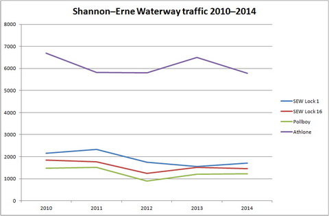
Shannon–Erne Waterway traffic 2010–2014
Clearly, not all boats go all the way through: if they did, the figures for Locks 1 and 16 might be the same. The hire bases for Locaboat, Riversdale and Corraquill were all on the Erne side of the summit level; does Lock 1’s excess of traffic over Lock 16 suggest that hirers, perhaps wishing to minimise the number of locks they passed through, headed for the Erne rather than the Shannon? The figures, which I presume are gathered automatically, do not distinguish between private and hired boats.
The other point that strikes me is that the level of traffic is actually quite low. I put in the figures for Pollboy and Athlone locks to allow comparison. SEW traffic is greater than that on the Lough Allen Canal, but it is not much greater than that on the River Suck to Ballinasloe. In that case, WI is [according to its Business Plan 2015] considering automating Pollboy Lock to reduce costs.

Pollboy lock passages 2005–2014
The SEW locks are already automated, but the costs and benefits may have to be re-examined, especially now that Locaboat has moved from Ballinamore to Quigleys Marina at Killinure on Lough Ree: I presume that that will result in less traffic on the SEW.
In 2006 Pollboy traffic was used as the basis for estimating likely traffic to Clones on the Ulster Canal’s “SW section”:
The total number of boat parties/groups for the SW section is assumed to be 600. This is based on a comparison with another “offshoot” like the Suck Navigation which had around 1,250 boat parties/groups in 2005 (obtained by dividing the passages through Pollboy Lock by 2) in a much busier section of the whole system. So, for the SW section, a level of around 50% (ie. 600) is regarded as a reasonable assumption.
Waterways Ireland Socio economic Summary Report for the NE and SW Sections of the Ulster Canal Final Report February 2006
Now that Pollboy’s traffic is half what it was in 2005, no doubt the estimate for the number of boats that would visit Clones, if a canal ever reached it, has likewise been halved, which would give an average of about ten boats a week over a seven-month season: four boats every Saturday and one a day for the rest of the week. Folk intending to build restaurants to cater for the cruiser traffic might be wise to reassess their investment plans:
In overall terms, the benefits of waterway restoration derive from the fact that these can facilitate a variety of leisure and recreational activity, that the users will benefit from this activity, and that there will also be wider spin-off benefits in the areas, e.g. facilities such as restaurants etc built to service canal traffic.
Department of Arts, Heritage and the Gaeltacht Restoring the Ulster Canal from Lough Erne to Clones Updated Business Case February 2015
There’s not enough business there for a burger van, never mind a restaurant.
But if Pollboy, the River Suck and Ballinasloe are no longer cited as support for the construction of a Clones Sheugh, the Shannon–Erne Waterway is still used as an example, in that and in other contexts. Take, for example, this:
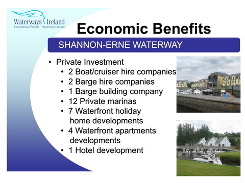
Shannon–Erne Waterway magic
I’ve nicked that from a slide show called Economic, Recreational and Social Benefits of Rural Waterways in Ireland, which was to be delivered [PDF] by Garret McGrath of Waterways Ireland at the World Canals Conference [PDF] in Milan in 2014.
Now, if the Shannon–Erne Waterway had caused all that construction activity, we’d have to drag Waterways Ireland before the Irish banking enquiry. Skipping lightly over the question of the ghost estates, and the departure of Locaboat from Ballinamore, we come to the real problem with this sort of stuff: the post hoc fallacy. We are invited to believe that
Well, maybe it did and maybe it didn’t, but the argument presented in the slide show isn’t sufficient to prove it. You would have to check to see whether there were any other possible explanations: any other changes that might have resulted in all that construction.
Along the Shannon–Erne Waterway, I can think of two other possible factors: Sean Quinn’s business empire and the Upper Shannon Rural Renewal Scheme, a tax dodge that applied in Leitrim, Longford, Roscommon, Cavan and Sligo, five of the six counties that had the highest rates of vacant housing (excluding holiday houses). So there are two problems here:
You can read more about that here, noting in particular, on the map, the areas around the upper Shannon and the SEW with vacancy rates of over 25%; you might wonder whether Waterways Ireland is wise to claim credit for housing over-development.
But my main concern here is a different one: that, if you want to claim credit for economic benefits that followed waterways development, you have to measure the benefits and subtract those attributable to other factors, such as Sean Quinn and the Rural Renewal Scheme. Then it would be useful if you compared the remaining benefits with the cost of constructing your waterway: it might then be possible to say that waterways development is a good investment.
It may be that such a study has been done on the SEW, but if it has I don’t know where it is; I would like to see it if it exists. Until then, I regard this sort of thing, from DAHG’s Business Case, as drivel:
The broad existence and nature of the potential socio-economic benefits of canals and restored waterways are therefore well established and not really at issue.
Sorry, minister: that’s rubbish. As far as I know no proper evaluation has ever been carried out on the costs and benefits of any restored or new-built Irish waterway. So you’re not getting away with that one.
Posted in Built heritage, Canals, Drainage, Economic activities, Engineering and construction, Extant waterways, Foreign parts, Ireland, Politics, Restoration and rebuilding, Shannon, Sources, Tourism, Ulster Canal, Uncategorized, Water sports activities, waterways, Waterways management
Tagged Athlone, Ballinasloe, boats, bridge, Cavan, Clones, construction, Corraquill, department of arts heritage and the gaeltacht, Erne, Ireland, Killinure, Leitrim, Locaboat, lock, Longford, Lough Allen, Lough Neagh, Pollboy, Quigleys, Riversdale, Roscommon, Sean Quinn, Shannon, Shannon-Erne Waterway, Sligo, Suck, summit level, tax, Ulster Canal, Upper Shannon Rural Renewal Scheme, vacant housing, waterways, Waterways Ireland
Isaac Slater’s Directory[i] of 1846 lists those carrying goods on inland waterways. There is a long list for Dublin; entries for other towns list those providing local services [there are some conflicts between the lists: see below]. However, the Dublin list shows only two carriers on the Royal Canal:
I noted here that two published histories of the Royal Canal, and a history of the Midland Great Western Railway [MGWR], suggested that the RCC/MGWR did not commence carrying goods themselves, on their own canal, until the 1870s. However, I had come across an MGWR ad, from 1853, beginning
The Directors will receive Proposals for the Haulage of their Trade Boats to and from Dublin and Longford and the River Shannon […].
The material in Slater’s Directory strengthens the notion that the RCC/MGWR did engage in carrying well before the 1870s, although the nature of the contractual relationships is not clear. Note also that Peter Clarke’s Appendix C[ii] lists “Boat Owners operating on the Royal Canal 1826 to 1847” including four RCC boats as well as four MGWR boats.
M’Cann and RCC both provide long lists of the destinations they serve:
I thought it might be interesting to show these destinations on a map. Note that the map is from the 25″ Ordnance Survey map of around 1900 rather than the 6″ of around 1840: I used it because it was clearer, but it shows features (eg railway lines) that were not present in 1846.
Click on the map to get a slightly larger version.
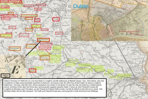
Royal Canal carriers M’Cann and RCC 1846 (OSI)
I can’t stand over every location marked on the map (as it were). Spellings of place-names were sometimes not those in use today; some place-names (Ballinamore, Ballymore, Newcastle) are used of two or more places that might have been those intended; I could not identify two places, Dunmore and Junction, although I suspect the latter may be the junction between the main line and the Longford Branch of the canal.
What is interesting, though, is the different emphases in the two firms’ marketing. The Royal Canal Company lists almost every location along its canal; M’Cann offers a wide range of destinations beyond the canal, presumably linked by cars on the roads, into Counties Longford, Cavan, Roscommon, Westmeath, Mayo and Sligo. The RCC serves some such destinations, but a smaller number of them.
Some of the locations listed are small places; my presumption — which I have not yet checked, but for which I have found some supporting examples — is that such places have mills, quarries or other industries that provide cargoes for the canal.
Both operators offer to serve destinations on the River Shannon, to which the Royal Canal is joined at Clondra/Richmond Harbour:
It is possible that goods to those places were carried by water, although (if steam tugs were not available) that would have been slow and uncertain; given that there were good roads leading from the west to the Shannon and throughout the region, it is, I think, likely that these destinations were served by road. I have no evidence on the matter save that the directory entries for Carrick-on-Shannon, Drumsna and Jamestown do not mention the availability of water transport.
Some of those destinations were served by direct road services from Dublin:
Competition presumably kept charges down.
Slater’s Directory lists six corn merchants in Longford, all with addresses at Market Square. One, John Delany, also had an address in Sligo and presumably exported via that port, carrying by road; the other five all had Dublin as well as Longford addresses.
One was John McCann, whose operations are shown in red on the map; he was the only one listed as a Dublin-based carrier, but three of the other four firms also carried goods regularly towards Dublin: Francis & John Pilsworth’s boats left Longford on Mondays and Thursdays, as did Thomas & Edward Duffy’s boats; Farrelly & Killard’s boats left once a week. Only Nicholas Butler did not offer transport. The Duffy and Pilsworth boats also carried goods in both directions from Mullingar. My guess is that carrying goods from others helped these merchants to cover the costs of their own fleets.
Peter Clarke’s Appendix C suggests that M’Cann’s fleet was the smallest of those based in Longford. The list is of “Boat Owners operating on the Royal Canal 1826 to 1847” but I am not entirely clear what the list shows. It seems unlikely, for instance, that the Midland Great Western Railway owned four boats throughout the period, as the company did not exist for most of it. Is the number of boats the largest that an owner had, or used, in a peak year, or an average over several years?
I don’t, therefore, know how to interpret the list but, assuming that the same methods were applied to all owners, it seems that the fleet sizes were these:
Neither Farrelly nor Killard is listed, but there are many others: Dunne 8, Kelly 6, Murtagh 6, Murphy 5, MGWR 4, Williamson 4, and many others with 1, 2 or 3 boats each. Again, it is not clear in which years those owners had those numbers of boats.
As far as I know, little has been written about the carrying companies, especially those of the nineteenth century. I would be glad to hear from anyone who can correct, supplement or comment on this information.
[i] I Slater’s National Commercial Directory of Ireland: including, in addition to the trades’ lists, alphabetical directories of Dublin, Belfast, Cork and Limerick. To which are added, classified directories of the important English towns of Manchester, Liverpool, Birmingham, Sheffield, Leeds and Bristol; and, in Scotland, those of Glasgow and Paisley. Embellished with a large new map of Ireland, faithfully depicting the lines of railways in operation or in progress, engraved on steel. I Slater, Manchester, 1846
[ii] Peter Clarke The Royal Canal: the complete story ELO Publications, Dublin 1992
![]()
Posted in Ashore, Built heritage, Charles Wye Williams, Economic activities, Engineering and construction, Extant waterways, Forgotten navigations, Industrial heritage, Ireland, Irish inland waterways vessels, Operations, People, Rail, Restoration and rebuilding, Shannon, Sources, Steamers, The cattle trade, Uncategorized, waterways, Waterways management
Tagged aqueduct, Arvagh, Athlone, Ballaghaderin, Ballina, Ballinafad, Ballinamore, Ballyfarnon, Ballymahon, Ballymore, Ballymote, Balnacarig, Balnalack, Boyle, Boyne, Broadstone, Carrick-on-Shannon, Castlerea, Colooney, Coolnahay, corn merchant, Downs Bridge, Dromod, Drumkeeran, Drumkerrin, Drumlish, Drumshambo, Drumsna, Dublin, Dunmore, Edgeworthstown, Elphin, Farrelly & Killard, Fenagh, Ferns, Francis & John Pilsworth, Glasson, Granard, Hill of Down, Jamestown, John Delany, John M'Cann & Sons, Junction, Kenagh, Kilcock, Lanesborough, Leixlip, Liffey lock, Longford, Market Square, Maynooth, Mohill, Moyvalley, Mullingar, National Commercial Directory of Ireland, Newcastle, Newtownforbes, Nicholas Butler, North Wall, Peter Clarke, Rathowen, road, Roscommon, Royal Canal, Royal Canal Company, Ruskey, Rye, Samuel Draper, Slater, Sligo, Strokestown, Tenelick Mills, Terlicken, Thomas & Edward Duffy, Thomastown, Toome Bridge, Tulsk
Here is an article from 1792 about the virtues of the River Shannon. It was written by an unidentified Traveller from Shincliffe, near Durham. It is interesting as an earlyish example of the Irish waterways cargo cult which, it has been pointed out to me, resembles the business plan of the underpants gnomes.
Posted in Ashore, Drainage, Economic activities, Engineering and construction, Extant waterways, Ireland, Natural heritage, Operations, People, Politics, Scenery, Shannon, shannon estuary, Sources, The cattle trade, Tourism, waterways
Tagged 1792, black cattle, Clare, estuary, Galway, Ireland, Kerry, King's County, Leitrim, Limerick, Longford, Offaly, Roscommon, Shannon, Shincliffe, Shinkliff, Tipperary, traveller, Westmeath
The Irish state’s dedication to the interests of builders has been well discussed in Conor McCabe’s very readable Sins of the Father. That dedication is evident along the upper reaches of the River Shannon, where ludicrous tax incentives encouraged the building of ridiculous numbers of houses. Some of them are intended for colonies of white settlers, as at Dromod, but even allowing for holiday and retirement homes there are far more houses than will ever be used.
IrelandAfterNama discusses “Housing vacancy 1991-2011 in the Upper Shannon Renewal Scheme counties” here. It shows that by 2011 21.8% of houses in Longford were vacant, 22.1% in Cavan, 22.2% in Sligo, 23% in Roscommon and 30.4% in Leitrim. Some of those vacancies are actually holiday homes, and there are other caveats, but Rob Kitchin’s (measured) conclusion is:
All five counties show a marked increase in the housing vacancy level. Even allowing for obsolescence and replacement, and demand for holiday homes, it is clear that housing was being built in excess of demand and in response to the tax incentives (as clearly illustrated by Figure 5). The result is a significant oversupply of stock and a helping hand in the collapse of the banks (see Figure 6 for vacancy levels per ED).
I’d put it rather more strongly: the Upper Shannon Renewal Scheme was a gigantic waste of resources.
Posted in Ashore, Economic activities, Engineering and construction, Extant waterways, Ireland, Operations, Politics, Scenery, Tourism, waterways, Waterways management
Tagged building, Cavan. Longford, Conor McCabe, economy, houses, Ireland, Leitrim, NAMA, renewal, Roscommon, Shannon, Sligo, tax, waterways
Ming Flanagan was the first to be elected a TD in the Roscommon South Leitrim constituency in the 2011 general election.

Ming launching himself on the Rockville Navigations
His sterling qualities were shown when, in September 2010, he kayaked down the Rockville Navigations, with a companion, to check this tourism and recreational resource (which I had brought to his attention in his capacity as Mayor of County Roscommon).
Another person on the side of righteousness is Paudie Coffey of Portlaw, mentioned favourably here; he was first home in Waterford, where he stood for Fine Gael.
Posted in Built heritage, Economic activities, Extant waterways, Forgotten navigations, Industrial heritage, Irish inland waterways vessels, Irish waterways general, Operations, Scenery, Suir, Water sports activities
Tagged 2011, boats, bridge, canal, Carrick-on-Suir, Clodiagh, Coffey, Dáil, Department of Community Equality and Gaeltacht Affairs, election, Ireland, Ireland waterways rockville, lock, lost, Malcolmson, Ming, Operations, Portlaw, quay, Rockville, Roscommon, Shannon, Suir, TD, turf, vessels, water level, Waterford, waterways, weir
Some time ago I wrote three pages about the Rockville Navigation, which is linked to Grange on the Carnadoe Waters in Co Roscommon.
I recently revisited the area. I was horrified, first, to find that the bridge — built in June 1765 — has been severely damaged, with large chunks of masonry in the cut beneath and with a crude wooden repair. How many bridges of that age are there in Co Roscommon? How many that are associated with one of the oldest navigations in the country? Please, someone, restore the bridge!

Damage to the bridge
Anyway, the more pleasant part of the day was the four hours that we spend descending, by dinghy and kayak, from the bridge to Grange. The route took us through artificial cuts, small lakes and sections of river, with very clear water and an extraordinary abundance of vegetation. This route would have been easily navigated by large wooden cots or similar boats, and it should be developed today as a canoe-and-small-boat trail. Even with very low water levels, we had no real problems, although someone has to end up with wet feet …. Here is an account of the trip.

Wading in the water
Posted in Extant waterways, Forgotten navigations, Industrial heritage, Irish waterways general, Scenery, The turf trade, Weather
Tagged Bellanagrange, Bellavahan, boats, bridge, canal, Cloonahee, Clooncraff, Derreen, Dooneen, Elphin, flow, Grange, Hillstreet, Ireland, Ireland waterways rockville, Lloyd, lost, Malet, Nablahy, quay, Roscommon, Shannon, Silver Eel, turf, vessels, water level, waterways

