Tag Archives: Banagher

How true these words are …

… even today:

The swivel bridges at Portumna and Banagher seem to have been badly situated with regard to the passage of vessels, both being placed in the concave bend of the river which makes it difficult, in blowing weather, and going down stream, to shoot the bridge safely.

From the BNA

That is from the Clare Journal, and Ennis Advertiser of 12 September 1850. The swivel bridges of yesterday are the navigation arches of today. The deficiencies of the Shannon Commissioners’ work were evident as soon as they had completed it.

However, although the article from which the sentence was taken is a condemnation of the Shannon Commissioners, the Journal was mistaken in blaming them for Portumna: that bridge was not built by the Shannon Commissioners.

The Shannon in winter

Downriver from Shannon Harbour to Dromineer in December 2014. It began as a bright, cold morning.

Shannon Harbour to Dromineer December 2014 01_resize

Leaving Shannon Harbour after icebreaking between the locks

Shannon Harbour to Dromineer December 2014 02_resize

Flooding to the south-east

Shannon Harbour to Dromineer December 2014 03_resize

But southward, look …

Shannon Harbour to Dromineer December 2014 06_resize

The Brosna

Shannon Harbour to Dromineer December 2014 73_resize

Heading for Banagher Bridge 1

Shannon Harbour to Dromineer December 2014 75_resize

Keeping close to the pontoons

Shannon Harbour to Dromineer December 2014 98_resize

Heading for Banagher Bridge 2

Shannon Harbour to Dromineer December 2014 103_resize

Heading for Banagher Bridge 3

There is a YouTube video of the shooting of the bridge here. It seems to start automatically, including sound; I don’t know how to avoid that.

Shannon Harbour to Dromineer December 2014 107_resize

Looking back at Banagher

Shannon Harbour to Dromineer December 2014 116_resize

Colours

Shannon Harbour to Dromineer December 2014 124_resize

Invernisk

Shannon Harbour to Dromineer December 2014 129_resize

Shannon Grove

Shannon Harbour to Dromineer December 2014 134_resize

Current

Shannon Harbour to Dromineer December 2014 140_resize

Scarpering heron

Shannon Harbour to Dromineer December 2014 146_resize

Colours

Shannon Harbour to Dromineer December 2014 149_resize

Marker and gauge

Shannon Harbour to Dromineer December 2014 151_resize

House

Shannon Harbour to Dromineer December 2014 169_resize

Boats at Meelick

Shannon Harbour to Dromineer December 2014 170_resize

Meelick weir

Shannon Harbour to Dromineer December 2014 174_resize

East bank

Shannon Harbour to Dromineer December 2014 176_resize

Protective boom

Shannon Harbour to Dromineer December 2014 181_resize

Sluices

Shannon Harbour to Dromineer December 2014 198_resize

Through Meelick Lock

Shannon Harbour to Dromineer December 2014 205_resize

One bird

Shannon Harbour to Dromineer December 2014 213_resize

Many birds

Shannon Harbour to Dromineer December 2014 221_resize

Reeds

Shannon Harbour to Dromineer December 2014 226_resize

Architecture

Shannon Harbour to Dromineer December 2014 228_resize

Munster Harbour

Shannon Harbour to Dromineer December 2014 233_resize

Delaying Eamon Egan

Shannon Harbour to Dromineer December 2014 235_resize

Gateway to civilisation

Shannon Harbour to Dromineer December 2014 237_resize

Connacht Harbour

Shannon Harbour to Dromineer December 2014 239_resize

Lough Derg: weather has changed

Shannon Harbour to Dromineer December 2014 243_resize

Journey’s end, Dromineer


The monsoon is coming …

… perhaps. The water depth at Banagher has stayed at around 2.1 metres but that at Athlone has gone down to about 2.0 metres. Are TPTB lowering Lough Ree so that it can store the water from the autumnal rains? Information welcome.

Pathé on Shannon

Shannon floods 1959 1

Shannon floods 1959 2

Pylons!

The Carrick-on-Suir creamery chimney (Shannon Scheme electrification)

Building the headrace


Lough Derg 27 December 2013

Water level

Dromineer 20131227 01_resize

The ramp to the pontoons in Dromineer is now sloping upwards

The water level at Banagher has risen about one metre in the past 35 days.

Wind

Dromineer 20131227 02_resize

Dromineer people need to drink more wine

Dromineer 20131227 04_resize

The ghost ship is back

Towers

Dromineer 20131227 05_resize

Dromineer sans ivy

Garrykennedy 20131227 02_resize

Garrykennedy

Garrykennedy 20131227 11_resize

Garrykennedy from a distance

Shelter

Dromineer 20131227 03_resize

Miranda in Dromineer

Garrykennedy 20131227 04_resize

Garrykennedy 1

Garrykennedy 20131227 05_resize

Fewer boats in WI berths this year, I think

Garrykennedy 20131227 03_resize

Garrykennedy 2


Levels

On 9 October 2013 minister Brian Hayes spoke in the Dáil about Shannon water levels, saying:

A meeting between the ESB, Waterways Ireland and the Office of Public Works to review the interim operating regime is due to take place shortly.

On 17 and 18 October 2013, in correspondence with Waterways Ireland, I learned that the meeting had not then taken place and that no date had been set. I have now sent WI another note asking whether the meeting has been held and, if it has, requesting a report on the proceedings and outcome.

In the meantime, I have put together two charts nicked from waterlevel.ie for Banagher and Athlone:

Athlone and Banagher water levels

Athlone and Banagher water levels

Both of them show the levels for the last 35 days. I’m sure that more data and much more sophisticated analysis would be required to reach any reliable conclusion, but my untutored impression is that, in what has been a fairly dry autumn, keeping Lough Ree low didn’t do much to keep Banagher low. If that is so, and if I’m right in thinking that this autumn was dry (see below), the outcome would not show whether lowering Lough Ree would help in a very wet season; it may be necessary to repeat the experiment next year while performing rain dances. I would be glad, though, to have comments from more erudite folk and, if I get any information from TPTB, I’ll publish it here. In the meantime, this CFRAM PDF provides background reading.

On the dryness: Met Éireann’s monthly report for September 2013 is headed “Dry everywhere; warm and dull in most places” while that for October says “Rainfall was above average except in parts of the West, Northwest and North”. Its report doesn’t, AFAIK, specify any stations in the Shannon catchment (apart from Shannon Airport), but those to the west were generally below average while whose to the east were above; it may be that the Shannon rainfall was moderate.

Lusmites rejoice

P J Norris commented here on the need for a walkway across Meelick Weir. The excellent KildareStreet.com tells us that the drought will end, as a Dáil written answer on 22 October 2013 showed.

Michael Kitt [FF, Galway East] had asked the Minister for Arts, Heritage and the Gaeltacht

… when it is proposed to reopen the walkway which spans the weir on the River Shannon in Meelick, County Galway; if funding has been provided for this work; if his attention has been drawn to the fact that this is an important local and tourist amenity; and if he will make a statement on the matter.

Jimmy Deenihan [FG, Kerry North/West Limerick] said

I am informed by Waterways Ireland that it is currently preparing a submission for planning permission to construct a new walkway over the River Shannon at Meelick. Indeed, environmental studies are underway to support the planning application.

I must advise the Deputy that construction work may only commence when all necessary permits have been received. It is Waterways Ireland’s intention to undertake works at the weir during 2014, subject to the appropriate statutory approvals being granted and financial resources being available.

Financial resources, eh? Perhaps a coin- (or note-)operated toll-gate on the walkway would be best.

Water levels in Athlone

At time of writing, the depth of water at Athlone Weir is 1.7m. “Staff gauge zero is 35.360m above Poolbeg datum”, which means the water level is 37.06m OD (Poolbeg). According to Bob Cullen’s 2002 article for Inland Waterways News [PDF], “The minimum navigation level in Lough Ree is 36.88m OD”, so if the level drops another 0.18m, about 7 inches, there may be a WI Marine Notice.

It seems that the dropping of the level of Lough Ree is intended to provide a buffer against flooding in the area from Athlone downstream to Meelick. According to Brian Hayes “A meeting between the ESB, Waterways Ireland and the Office of Public Works to review the interim operating regime is due to take place shortly.” [I have asked Waterways Ireland for a report on the meeting.]

But, if we are to believe the Dublin Evening Mail, the Shannon Commissioners took a rather more robust attitude to flooding downstream of Athlone: steamers [and PR] came first.

Canal carrying 1846: the Grand Canal

Isaac Slater’s Directory[i] of 1846 lists those carrying goods on inland waterways. Most of the carriers on the Grand Canal, which runs from Dublin to the River Shannon with various branches, claim to serve a modest number of places, but Thomas Berry & Co have a very lengthy list. So long is their list that it will require two maps to show all the places they served, with a third map for the rest of the carriers.

Note that the maps are from the 25″ Ordnance Survey map of around 1900 rather than the 6″ of around 1840: I used it because it was clearer, but it shows features (eg railway lines) that were not present in 1846.

There may be some cases where I have misidentified a destination; I would be grateful to have my attention drawn to such cases.

Click on a map to get a slightly larger version.

Thomas Berry & Co

Thomas Berry & Co midland and south routes

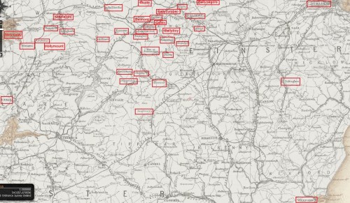
Thomas Berry & Co midland and southern destinations (OSI)

The canal runs from Dublin, at the top right, left (roughly west) through Tullamore to Shannon Harbour, where it meets the river; there was an extension to Ballinasloe on the far side of the Shannon. Berrys served places along the canal and several others fairly close to it, but it looks to me as if there were three routes by road beyond that:

  • via Banagher (which has a bridge across the Shannon) to Eyrecourt and Killimor
  • from Ballinasloe to Loughrea and district and then south-west to Ennis in Co Clare
  • perhaps from Tullamore to Birr [Parsonstown], Roscrea (including Shinrone, Cloughjordan and Borrisokane) and Templemore.

There are also two outliers for which I can think of no plausible explanation: Baltinglass and Wexford. Perhaps their inclusion was a mistake. Certainly Berrys, like John M’Cann & Sons on the Royal Canal, seem to have had extensive road networks (perhaps using car-owning subcontractors?) to supplement their water-borne routes, but I don’t see why they would take on a route no part of which could sensibly have been conducted by inland navigation.

The next map shows the north-western destinations served by Berrys.

Thomas Berry & Co western routes

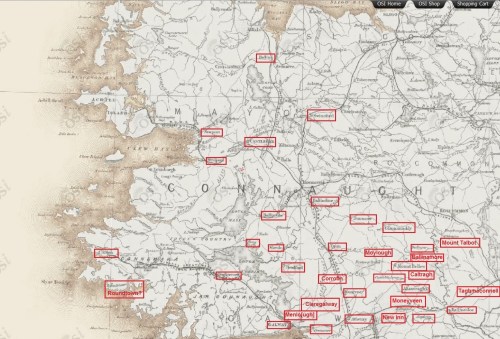
Thomas Berry & Co north-western destinations (OSI)

You can see that their network covered much of County Roscommon and went almost as far west into County Galway as it was possible to go; it also extended northwards into County Mayo.

I have not attempted to check what industries might have made these towns and villages worth serving. Berrys certainly seemed keen to take as much as possible of the traffic from west of the Shannon towards Dublin — excluding such of it as went by the Royal Canal: it is interesting to compare these maps with that for M’Cann on the Royal.

Finally, note that along the canal itself Berrys listed only destinations towards the western (Shannon Harbour) end: it seems likely that the roads took the valuable traffic from the eastern end into Dublin. There were no doubt turf boats taking fuel in from closer to Dublin, but they were not general carriers.

Other carriers

Now for the rest of the carriers.

Grand Canal carriers 1846 excl Thomas Berry

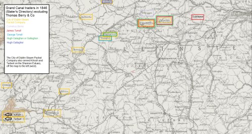
Grand Canal carriers 1846 excluding Thomas Berry (OSI)

I have included the Shannon here as well as the Grand Canal; however I have covered the Barrow Line of the Grand Canal, as well as the navigable rivers Barrow, Nore and Suir, in a separate post. Of the carriers listed here, only the City of Dublin Steam Packet Company [CoDSPCo] (which employed horses to pull its boats on canals) ventured on to the Barrow Line, serving Portarlington and Mountmellick.

Berrys and the CoDSPCo were by far the largest firms on the Grand. I don’t know the size of the Berrys fleet, but the CoDSPCo had 52 barges in addition to its Shannon (and Irish Sea) steamers. Note that only on the middle Shannon, around the junction with the Grand Canal, and at Ennis did the two firms serve the same destinations: the CoDSPCo seems to have had the lower Shannon trade to itself.

With one exception, all the carriers, including Berrys, had Dublin depots at Grand Canal Harbour, James St; the Grand Canal Docks at Ringsend, joined to the Liffey, were not mentioned.

The exception is Hugh Gallagher, whose only listed destination was Athlone. It would be interesting to know how he served Athlone: whether by road or by water and, in the latter case, whether he used a steamer. I do wonder whether Hugh Gallagher might be the same person as the Hugh Galaghan (also Gallaghan) who served Philipstown [now Daingean], Tullamore and Shannon Harbour.

George Tyrrell is another who is listed with but a single destination, Banagher, whereas James Tyrrell is listed as serving Tickneven, Philipstown, Tullamore — and Edgeworthstown, which must be a mistake as it is closer to the Royal Canal.

Finally, Cornelius Byrne is shown as serving two destinations: Philipstown and Kilbeggan (which has its own branch off the main line of the canal).

Other information

A little extra information is available from the entries for towns other than Dublin in the Directory:

  • Naas has its own branch from the main line of the canal, but the directory says that “TO DUBLIN, there are Boats, as occasion require, but they have no fixed periods of departure.”
  • Edenderry also has its own branch, short and lock-free, but there is no mention of its being served by trade boats
  • Kilbeggan, with a longer, leakier, lock-free branch, was served by the CoDSPCo’s and Thomas Byrne’s boats travelling to Dublin three times a week. Is this Thomas Byrne related to the Cornelius Byrne mentioned above? It seems that Byrne went only eastward for only the CoDSPCo’s boats went westward (to Shannon Harbour, Ballinasloe and Limerick) two or three times a week
  • at Banagher, Fleetwood Thomas Faulkner of Main Street was the CoDSPCo agent; a downstream steamer left Shannon Harbour after the [passenger] boat from Dublin arrived and called at Banagher’s Bridge Wharf; an upstream steamer from Limerick called every afternoon at 3.00pm and met the night boat travelling to Dublin by the Grand Canal. I presume that this happened on every day except Sunday.

More

As far as I know, little has been written about the carrying companies, especially those of the nineteenth century. I would be glad to hear from anyone who can correct, supplement or comment on this information.

My OSI logo and permit number for website


[i] I Slater’s National Commercial Directory of Ireland: including, in addition to the trades’ lists, alphabetical directories of Dublin, Belfast, Cork and Limerick. To which are added, classified directories of the important English towns of Manchester, Liverpool, Birmingham, Sheffield, Leeds and Bristol; and, in Scotland, those of Glasgow and Paisley. Embellished with a large new map of Ireland, faithfully depicting the lines of railways in operation or in progress, engraved on steel. I Slater, Manchester, 1846

Can wisdom be put in a silver rod?

Or love in a golden bowl?

My mole doesn’t know, but diesel can be put in a boat’s fuel tank at Silver Line in Banagher, the latest addition to the roll of honour: the traders holding licences to sell marked diesel [.xls] along the Shannon.

The eight licensed sellers are (north to south):

  • CarrickCraft, Carrick-on-Shannon
  • Emerald Star, Carrick-on-Shannon
  • Rooskey Craft & Tackle, Rooskey Quay
  • Hanley’s Marina, Ballyleague (opposite Lanesborough)
  • Quigley’s Marina, Killinure, Lough Ree
  • CarrickCraft, Banagher
  • Silver Line, Banagher
  • Emerald Star, Portumna.

The excitement is too much for me. I think I’ll lie down for a bit.