Tag Archives: bridge

Important topics in Ireland 1845–1850

I thought it would be interesting to ask the British Newspaper Archive what people were reading about in newspapers published in Dublin between 1 January 1845 and 31 December 1850. The BNA has scans of two Dublin newspapers for that period, the Freeman’s Journal and the Dublin Evening Mail. I used the archive to search for four different words in those newspapers in that period; I then counted the numbers of results.

On the first round, I included ads and family notices.

Newspaper terms incl ads 1845–1850

Terms in Dublin newspapers (incl ads) 1845–1850

I guessed that the numbers for steam and railway might be exaggerated by their inclusion in ads so, on the second round, I excluded both ads and family notices. The result was as expected.

Newspaper terms excl ads 1845–1850

Terms in Dublin newspapers (excl ads) 1845–1850

I then asked Google’s Ngram machine to count the numbers of occurrences of four pairs of words between 1845 and 1850. I asked it to do a case-insentitive search, but it can’t do that for “compositions” (combinations of words), so it counted:

Ireland+potato
Ireland+steam
Ireland+famine
Ireland+railway.

Here is what it came up with, but whence I know not, other than that it searched the corpus English. The embedding process doesn’t seem to be working, so I’ve left the code here but also cut and pasted the output.

Google Ngram

Google Ngram

I suspect that, in recent times, the amount written about steam and railways of the period 1845–1850 in Ireland has been rather less than that about potatoes and the famine.


Splendid chaps, these arty types

I take it all back: I’ll never say another rude word about art gallery folk.

Well, not many, anyway.

The splendid folk at the National Gallery of Ireland have an online searchable archive that allows you to look at pics, download small watermarked versions and buy larger versions if you would like to do so. And “searchable” doesn’t just mean searchable by artist or type of paint or whatever it is: you can put in important terms like “steamer” and “shannon” and “canal”.

Admittedly you don’t get much back: two steamers, none of interest on this site, nothing about the Shannon and twelve canal scenes, only two of which are in Ireland. One of them, though, is very interesting indeed, and you can see it if you use

P4457

as your search term.

You should get an 1809 pic by one John Henry Campbell entitled “Ringsend and Irishtown from the Grand Canal, Dublin”, showing three wooden canal-boats, not particularly well moored, with their crews settling in (it appears) for the evening with fires lit and some with shelters rigged.

I can’t work out where they are, though. To get Ringsend lined up with Howth in quite that way, you’d have to be pretty close to the Grand Canal Docks, I’d have thought. Any guesses or deductions?


Carrick-on-Suir to Clonmel towing-path

Messrs RPS, consulting engineers, have been asked by South Tipperary County Council

… to design a minimal impact walking & cycling greenway route along the towpath of the River Suir between the towns of Clonmel and Carrick-on-Suir.

I have written about this stretch of the river here, so I was pleased to be asked to submit some comments and I welcomed the proposal. I made three suggestions, commenting more on principles than on details, which local people would know more about than I do.

First, I said that the heritage artefacts along the route should be protected and, if possible, explained. That might be done unobtrusively by making online information available to those equipped with smartphones. Such systems are used by the Canal & River Trust in Britain (here’s an example) and I understand that there have been experiments in using them on the Royal Canal here.

Second, I said that use by walkers requires more than a good trail: walkers also need safe parking places for their cars and information about public transport services that will return them to their starting-points. Car parks themselves need not be along the greenway but the information has to be provided there.

Third, there is scope for more use of the waterway itself, especially by canoes, kayaks and rafts, as well as by anglers. While such uses are (I imagine) outside RPS’s brief, I thought that it would be better to take account now of the needs of such users, and to ensure that the engineering would be able to cater for them in the future (I was not proposing that facilities necessarily be provided now), rather than to have to re-engineer the greenway later. My main concern was provision for enhanced access by rescue services, and Carrick-on-Suir River Rescue would probably be the best people to comment on that. I also suggested that a certain amount of unobtrusive hard edging along the towing-path might be of assisstance to boaters.

If you’ve looked at my page on this section of the Suir, you’ll know that it’s very scenic. Up to now, not all of the route has been accessible and making it so is a Good Thing — and at relatively low cost.


The Mahmoudié Canal

There is a possible link between the Mahmoudié Canal, which ran from Alexandria to the Nile, and Irish waterways. I have not managed to establish a definite link to this Irish canal-boat but it is not ruled out either, and a few other Irish connections came up along the way: Oscar Wilde’s father, for instance, who wrote about the Boyne and the Corrib, and sent his most famous son to school on the Erne, travelled on the Mahmoudié Canal.

And did you know that, in the early 1840s, you could buy bottled Guinness and Bass in Cairo? Or that, to transport 50 people (including 12 ladies and 3 female servants) and 3 bags and 62 chests of mail across 84 miles of desert, you would have needed, in 1841,

  • 130 camel men, donkey men and servants
  • an escort of 17 Arab horsemen
  • 145 camels
  • 60 donkeys
  • 12 saddle horses
  • 12 carriage horses
  • 7 carriage camels
  • 12 donkey chairs: “for invalids, or ladies, the donkey-chair forms as easy a conveyance as a palanquin or sedan”
  • 3 two-wheeled carriages
  • 1 four-wheeled carriage?

Or that, to reduce the number of rats and insects on a cangia (sailing boat) on the Nile, you should sink it for two or three days before boarding?

You can read about all of that and more in this PDF. However, it’s not for the faint-hearted: it’s 51 pages, with over 300 endnotes (which you don’t have to read) and lots of links for those who are really interested. There are illustrations in some of the linked materials.

The Mahmoudié mystery v04 iwh [PDF]

Marty Whelan, St Saran, Colonel l’Estrange and the Tessauren Ferry

Marty Whelan, a youthful disk-jockey chap with an insignificant amount of facial hair, presents a morning programme on the wireless. One day last week, discussing traffic problems with a chap from AA Roadwatch, he considered the origin of the name of L’Estrange Bridge, whose location neither he nor his collocutor knew.

L'Estrange Bridge (2003)

L’Estrange Bridge (2003)

It had been mentioned on this site as the location of a fatal motoring accident in December 2011 and it is, of course, a useful stopping place for those who, driving to Athlone, like to stop to consume the coffee (and any comestibles) they may have purchased in the award-winning Spar shop in Cloghan.

I emailed Mr Whelan, with a link to the location on the OSI map.

Tessauren 1

L’Estrange Bridge and Moystown House

I speculated that, as the nearby Moystown House was owned by the l’Estrange family (as was Huntston or Hunstanton, across the road), the Grand Canal Company might have had to buy land from them and, with the aim of keeping the cost down, have agreed to name the bridge after the landowner (a tactic that the National Roads Authority might adopt).

I should make it clear that I have not researched the land purchases of the Grand Canal Company in the area, so this should not be taken as definitive. I note, from Fred Hamond’s Bridges of Offaly County: an industrial heritage review (for Offaly County Council, November 2005), that the date on the bridge is 1800, although the canal was not opened until 1804; as Fred says:

Most [bridges] were built before their respective stretches of canal opened […].

The Parliamentary Gazetteer of 1846 says:

The principal artificial features are the mutually adjacent demesnes of Moystown and Hunstanton, the residences of the Messrs L’Estrange, situated on the Brosna. “Though Moystown,” remarks Mr Fraser, “has not extensively diversified park scenery to boast of, and is environed by deep brown bog, there is, in the style of the house, in the arrangement of the plantations, and in the beautiful evergreen oaks and other ornamental trees which adorn the lawn, a character which carries us back to the gentlemen’s seats of the olden times. This demesne is watered by the Brosna, which pays its ample tribute to the Shannon at thetermination of the grounds, and where also the Grand Canal crosses the river in its progress to Ballinasloe.”

Lewis’s Topographical Dictionary of 1837 says that Colonel l’Estrange was living at Moystown at the time, William l’Estrange was living at Kilcummin, a little distance north of Huntston, and Major Carlton (a relative, I think) at Huntston.

A quick search suggests that the l’Estranges did occupy land there in 1800, but I cannot claim to have carried out a thorough investigation.

What was of more interest to me was that the Parliamentary Gazetteer extract was from an item headed Tessauran, Tiseran or Kilcally:

Tessauren 2

The parish of Tisaran

TESSAURAN, TISERAN, or KILCALLY, a parish in the barony of Garrycastle, 2¼ miles north-west by west of Cloghan, King’s co., Leinster. Length, south-westward, 3¾ miles; extreme breadth, 2½; area, 7,316 acres, 2 roods, 12 perches, — of which 106 acres, 3 roods, 38 perches are in the river Shannon. Pop., in 1831, 2,032; in 1841, 2,029. Houses 346. The north-western boundary is traced by the Blackwater; the south-western boundary, by the Shannon; and the south-eastern boundary, by the Brosna. All the northern district, part of the eastern, and most of that along the Blackwater, are bog; much of that along the Shannon is lowland meadow; and most of the remainder is dry limestone land, pleasant in appearance, and possessing a considerable aggregate of embellishment.

Some time ago, I asked here about Tessauren Ferry, but had no response. I found the term in F E Prothero and W A Clark eds Cruising Club Manual: A New Oarsman’s Guide to the Rivers and Canals of Great Britain and Ireland George Philip & Son, London 1896. His entry for the Grand Canal included this at 79¼ miles from Dublin:

Entrance into the Shannon at Tessauren Ferry.

I have not seen the term used anywhere else. The ferry is of course that provided by the Shannon Commissioners to enable horse-drawn boats to cross the Shannon to the Ballinasloe Line of the Grand Canal. It would be nice to find other instances of the use of Prothero’s term.

Tessauran, Tisaran, Tiseran, Tessauren (and perhaps there are other variants) is the name of the parish north-east of the junction between the Brosna and the Shannon. It is odd that the ferry’s eastern departure point was actually outside the parish, because the Brosna was the boundary and the ferry started from the south side of the canal and the Brosna.

Tessauren 3

Tisaran parish and the ferry

The other link I had not made was that between Tessauren and St Saran, whose well I photographed some years ago, which means that I was on the grounds of Moystown House.

Tessauren 4

St Saran’s well (Tobersaran)


St Sarans Well near Shannonbridge 03_resize

St Saran’s well

St Sarans Well near Shannonbridge 04_resize

Looking into the well


So one mystery solved, as an accidental result of a remark on the wireless, but more information about the use of the term Tessauren Ferry would be welcome.

My OSI logo and permit number for website

The Shannon in winter

Waterways Ireland has kindly supplied me with the Shannon traffic figures for January and February 2014. The usual caveats apply. I have not made any charts because the traffic levels were so low:

  • in January, nineteen boats were recorded; of them, ten went through Portumna Bridge. Thirteen boats were private and six hired
  • in February, thirteen boats were recorded, five of them at Portumna; nine were private and four hired.

The total of 32 boats in the two months is extremely low. Since 2003, the Jan–Feb totals have been:

2003   45
2004 112
2005  67
2006  92
2007 127
2008  72
2009 124
2010  72
2011 114
2012  94
2013  97
2014  32

As Waterways Ireland intends to “prioritise navigation opening times to the times of greatest use, in order to achieve maximum use of resources available”, we may expect the Shannon to be closed in winter.


Bernard Durkan TD

I have sent this email to Bernard Durkan, a Fine Gael TD for Kildare North:

Greetings.

It is reported that, in the Dáil on 6 March 2014, you said:

“The canal restoration that has taken place over the past 50 years was largely done through voluntary effort. While Waterways Ireland has an involvement in upgrading the canals, and it has a responsibility that we all respect, cognisance should be taken of the huge voluntary effort in the restoration of the canals.”

I would be grateful if you could tell me the evidence for your assertion. How did you measure restoration and the respective contributions of volunteers and of Waterways Ireland and its predecessor bodies?

Best wishes
bjg

I may confess that I think he’s talking through his hat, but I will read his evidence with interest.

Rural nitwits and retirement communities

I’ve just been writing elsewhere to the effect that national politicians are a pack of nitwits. I was cheered therefore, in a sense, to note that local politicians, at least in Co Mayo, are (if possible) even more thick-headed than their national counterparts.

However, I am happy to be able to offer a solution, one that kills two birds with one stone. There are, it seems, many English pensioners living in poverty on boats on the canals and unable (or at least unwilling) to pay for the privilege. I had intended to suggest that Waterways Ireland should provide them with moorings away from the honeypot areas.

WI could then charge more for berths at, say, Hazelhatch, Sallins, Blanchardstown and Lowtown, catering for those in work who could afford a couple of thousand a year, while the pensioners, who don’t need to be within commuting distance of Dublin, could be accommodated in rural areas where their small additional spending would make a difference. That would help to increase those community and economic benefits to which the subsidy-seeking boat-owners draw our attention, bringing spending to deprived rural areas.

I was thinking of Pollagh, for instance: it has a pub, a shop, a church and a visiting burger van, and easy access to supplies of turf.

But the Mayo problem reminds me that Mayo too has lakes. So why not ship the boats to Mayo? As the canals byelaws provide that boats should not discharge any water other than from engine-cooling, these boats must be fitted with holding tanks or other non-discharging loos, so there would be no pollution problem. In fact Mayo could advertise itself to the world as offering floating retirement communities at modest cost, thus renewing its own population while solving a problem for boat-owners. I thnk this is a winner.

Shannon traffic 2013

Some weeks ago Waterways Ireland kindly supplied me with the Shannon traffic figures for the final three months of 2013 and I have just now had a chance to add them to my spreadsheets and produce some graphs.

The usual caveats apply: the underlying figures do not record total waterways usage (even for the Shannon) as, for instance, sailing, fishing or waterskiing on lakes or river stretches, which did not involve a passage through a lock or Portumna Bridge, would not be recorded. The passage records are our only consistent long-term indicator of usage of the Shannon but they would not show, for instance, a change in the balance of types of activities from those in larger cruising boats to those in smaller (sailing, fishing, waterskiing) boats. On the other hand, they do include the Shannon’s most significant tourism activity, the cruiser hire business.

It is good to note, incidentally, that, in its draft Corporate Plan 2014–2016, Waterways Ireland says that it intends to

Develop and implement a research programme to measure waterway usage and inform planning and development.

It won’t be easy to do, but we need much better measures of all types of activities on all seven of the waterways managed by WI.

The final outcome for 2013 won’t greatly surprise anyone who has read earlier bulletins on this subject, like this covering the figures to end-September 2013. All the illustrations are based on information supplied by Waterways Ireland, with some minor adjustments by me to eliminate anomalies, but the interpretation and comments are mine own.

All boats full year

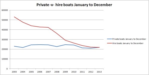
Total Shannon traffic 2003–2013, private and hired

The decline in traffic since 2003 seems to have been halted …

All boats full year %

Total Shannon traffic as a percentage of 2003 traffic

… but it is 40% below what it was in 2003.

Private boats full year %

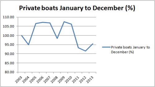
Private-boat traffic 2003–2013 as a percentage of 2003 traffic

Traffic in private boats seems to be recovering, but what is perhaps more significant is that it never went more than 10% above or below the 2003 figure. It has been remarkably stable over the period, despite the economic crash and despite the anecdotal evidence of boats being sold to overseas owners and trucked out of the country. Perhaps larger boats were replaced by smaller? Perhaps only boats bought in the boom were sold in the bust? Unfortunately the deficiencies of the registration system make it very difficult to determine what has been happening.

Hire boats full year %

Hire-boat traffic 2003–2013 as a percentage of 2003 traffic

But if private-boat traffic has been remarkably stable since 2003, the same cannot be said of hire-boat traffic. The best that can be said of 2013 is that the figures didn’t get [much] worse, but a 60% decline since 2003 is really, really dreadful.

WI’s draft Corporate Plan, which does not explicitly mention the hire industry, talks of

… unlocking opportunities to achieve recreational growth, and economic and social development.

I don’t know whether that omission means that WI sees little prospect of a rejuvenated hire-boat industry. And I note that, other than in the titles of organisations, the draft plan rarely mentions tourism or tourists. Are the waterways only for natives? If so, is that a deliberate policy decision? Or is there something that could be done, cheaply, to help to revive waterways tourism?

Emma Kennedy, writing in the Sunday Business Post on 23 February 2014, wrote about Fáilte Ireland’s latest brainwave, which is to “target” three groups:

  • social energisers, which are gangs of young people interested in “new and vibrant destinations”, which I take to mean Temple Bar
  • culturally curious folk aged 50 or over, with money, who are interested in “exploring new landscapes, history and culture”
  • great escapers, who like energetic rural holidays with their partners.

No families with kids, I see, although “Families & Loved Ones” (the latter term, by the way, nowadays seems to mean either dead people or their relicts) were one of the two “primary target customer segments” identified in Fáilte Ireland’s Inland Cruising Market Development Strategy. (Fat lot of good that strategy did, but we mustn’t be bitter.)

Anyway, without having done any market studies (though WI has funded lots of them), it seems to me that there is scope for more tourism on the waterways, but it might not be on traditional cruisers. It might involve outdoor activities like cycling and walking along the canals and Barrow: WI’s plan discusses them, but without adverting to an overseas market. And it might involve small-boat activities — canoeing, touring rowing, small-boat sailing, camping — on Shannon, Erne and SEW: WI says it will support micro-enterprises, and those providing outdoor activity holidays may need expertise and assistance rather than hard cash.

I admit to having little evidence on this, but it seems to me to be too early to give up on the tourism potential of the waterways. And the decline of the cruiser hire business does not necessarily mean that all waterway tourism is doomed.

Private -v- hire full year

Private boats overtake hire boats

That said, 2013 was the year when, for the first time since Noah was an Able Seaman, the number of passages by private boats exceeded that by hire boats.

Checkpoints 2013

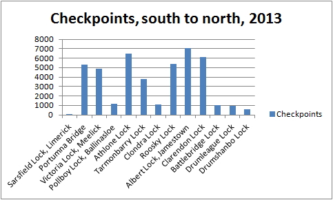
The points at which numbers were recorded

Finally, this chart suggests that any structures that were not built by the Shannon Commissioners in the 1840s will not attract many visitors. The extensions off the main stem of the Shannon — south to Limerick, west to Ballinasloe, east through Clondra, north to Lough Allen — are much less used than the main line from Lough Derg to Lough Key. It seems unlikely that any further extensions, especially to small towns that it would take three hours (at canal speed) to get to, are likely to be any more successful in attracting traffic.

The Dublin to Lough Neagh Canal

Here’s another lunatic canal proposal: one I hadn’t come across before.

Proposal for making a line of navigation from Dublin to Lough Neagh

It is proposed by several noblemen and gentlemen of the county of Meath, and of the manufacturing counties of the north of Ireland, the river Boyne company, with several merchants of the city of Dublin and of the commercial towns of the north, to complete, by private subscription, together with such aid as parliament may be pleased to grant, a navigable canal, from the royal canal at Blanchardstown, near Castleknock, in the county of Dublin, to Navan, Kells, Balieborough, Monaghan, Armagh, and Lough Neagh.

The object of this undertaking is to open a direct intercourse between the metropolis and the manufacturing towns of the north; and it is conceived, by the proposers for this undertaking, that a canal, large enough to navigate twenty-five ton boats on, would answer the trade; and in consequence of many locks being already made, rising from the city of Dublin to Castleknock, they think such a canal could be carried on very cheaply from thence to Navan, where another ascent takes place, through the locks of the Boyne navigation to the level of the town of Kells, and the river Blackwater, at Glevin’s bridge, three miles north of that town.

Claven's Bridge over the Blackwater near Kells

Claven’s Bridge over the Blackwater near Kells

My OSI logo and permit number for website

The country northward appears so fit for inland navigation, that no doubt can be entertained of being able to cut cheap canals through it. It is therefore most humbly hoped, if a line for a canal in this direction should be found to answer the expectation, that parliament will be pleased to allow the undertaking to become a part of the intended system of inland navigation of Ireland, and to a share of whatever bounty parliament may grant to accomplish the same.

The advantages that would arise to the nation from this undertaking, are too obvious to take up the time of this honourable house with any comment upon them.

A Atkinson Esq (late of Dublin) Ireland exhibited to England, in a political and moral survey of her population, and in a statistical and scenographic tour of certain districts; comprehending specimens of her colonisation, natural history and antiquities, arts, sciences, and commerce, customs, character, and manners, seats, scenes and sea views. Violent inequalities in her political and social system, the true source of her disorders. Plan for softening down those inequalities, and for uniting all classes of the people in one civil association for the improvement of their country. With a letter to the members of His Majesty’s Government on the state of Ireland Vol II Baldwin, Cradock, and Joy, London 1823