Category Archives: Irish inland waterways vessels

Le bateau monstrueux*

Voila le grand bateau de Monsieur Thibault.*

Enormous Le Boat vessel 01_resize

Le grand bateau a Athlone*

I’ve never been entirely clear why an Anglo-German travel group should have adopted a macaronic Anglo-French name, Le Boat, for its business of providing “self-drive boating holidays on the inland waterways of Europe“, which is one of the activities within the Marine Division of its Specialist & Activity Sector, which is in turn one of its three main sectors.

Somewhere within Le Boat is the Irish operation, Emerald Star; that brand name is used on the leboat.net website but not, as far as I can see, on the leboat.co.uk site. Furthermore, Emerald Star is not listed amongst TUI Travel’s brands. I mention this because M Thibault’s boat carries the Le Boat brand, not the Emerald Star. I have asked the TUI Travel press office whether the Emerald Star brand is being withdrawn.

Enormous Le Boat vessel 02_resize

Voila le gros chien sur le grand bateau*

Anyway, the boat itself is interesting. It’s Le Boat’s Vision, made by Beneteau. There are variants: it comes with either three or four bedrooms, diesel or hybrid, SL or not. It is available for sale as well as for hire; a buyer can place it in the Le Boat fleet and earn some money too.

There is a brief description here with a link to Waterways World‘s recent report about the boat. There is more here and here. It is extremely well equipped.

Enormous Le Boat vessel 03_resize

Le Le Boat bateau*

Back in the 1970s, many boat owners had either small or elderly boats; a secondhand cruiser, sold out of one of the hire fleets, was the height of luxury, and on average the hire boats were more luxurious than the private (or that at least was my impression). In recent years that has changed; private boats became luxurious and equipped with more toys than hire boats had.

Le Boat’s Vision may change the balance again, but only a very large company could afford a fleet of such boats: Waterways World gave the price as STG£249000.

[* translations by Google]

Belle of Barley Harbour

If you own the yacht Belle, which is at Barley Harbour on Lough Ree, you may wish to visit it. Its wooden doors are missing and there is what I think is a mink on board. I’m afraid I don’t know the owner and don’t know how to contact her or him.

Belle at Barley Harbour 01_resize

Belle by night

Belle at Barley Harbour 07_resize

Doors missing

Belle at Barley Harbour 05_resize

Mink 1

Belle at Barley Harbour 06_resize

Mink 2


Canal carrying 1846: the Grand Canal

Isaac Slater’s Directory[i] of 1846 lists those carrying goods on inland waterways. Most of the carriers on the Grand Canal, which runs from Dublin to the River Shannon with various branches, claim to serve a modest number of places, but Thomas Berry & Co have a very lengthy list. So long is their list that it will require two maps to show all the places they served, with a third map for the rest of the carriers.

Note that the maps are from the 25″ Ordnance Survey map of around 1900 rather than the 6″ of around 1840: I used it because it was clearer, but it shows features (eg railway lines) that were not present in 1846.

There may be some cases where I have misidentified a destination; I would be grateful to have my attention drawn to such cases.

Click on a map to get a slightly larger version.

Thomas Berry & Co

Thomas Berry & Co midland and south routes

Thomas Berry & Co midland and southern destinations (OSI)

The canal runs from Dublin, at the top right, left (roughly west) through Tullamore to Shannon Harbour, where it meets the river; there was an extension to Ballinasloe on the far side of the Shannon. Berrys served places along the canal and several others fairly close to it, but it looks to me as if there were three routes by road beyond that:

  • via Banagher (which has a bridge across the Shannon) to Eyrecourt and Killimor
  • from Ballinasloe to Loughrea and district and then south-west to Ennis in Co Clare
  • perhaps from Tullamore to Birr [Parsonstown], Roscrea (including Shinrone, Cloughjordan and Borrisokane) and Templemore.

There are also two outliers for which I can think of no plausible explanation: Baltinglass and Wexford. Perhaps their inclusion was a mistake. Certainly Berrys, like John M’Cann & Sons on the Royal Canal, seem to have had extensive road networks (perhaps using car-owning subcontractors?) to supplement their water-borne routes, but I don’t see why they would take on a route no part of which could sensibly have been conducted by inland navigation.

The next map shows the north-western destinations served by Berrys.

Thomas Berry & Co western routes

Thomas Berry & Co north-western destinations (OSI)

You can see that their network covered much of County Roscommon and went almost as far west into County Galway as it was possible to go; it also extended northwards into County Mayo.

I have not attempted to check what industries might have made these towns and villages worth serving. Berrys certainly seemed keen to take as much as possible of the traffic from west of the Shannon towards Dublin — excluding such of it as went by the Royal Canal: it is interesting to compare these maps with that for M’Cann on the Royal.

Finally, note that along the canal itself Berrys listed only destinations towards the western (Shannon Harbour) end: it seems likely that the roads took the valuable traffic from the eastern end into Dublin. There were no doubt turf boats taking fuel in from closer to Dublin, but they were not general carriers.

Other carriers

Now for the rest of the carriers.

Grand Canal carriers 1846 excl Thomas Berry

Grand Canal carriers 1846 excluding Thomas Berry (OSI)

I have included the Shannon here as well as the Grand Canal; however I have covered the Barrow Line of the Grand Canal, as well as the navigable rivers Barrow, Nore and Suir, in a separate post. Of the carriers listed here, only the City of Dublin Steam Packet Company [CoDSPCo] (which employed horses to pull its boats on canals) ventured on to the Barrow Line, serving Portarlington and Mountmellick.

Berrys and the CoDSPCo were by far the largest firms on the Grand. I don’t know the size of the Berrys fleet, but the CoDSPCo had 52 barges in addition to its Shannon (and Irish Sea) steamers. Note that only on the middle Shannon, around the junction with the Grand Canal, and at Ennis did the two firms serve the same destinations: the CoDSPCo seems to have had the lower Shannon trade to itself.

With one exception, all the carriers, including Berrys, had Dublin depots at Grand Canal Harbour, James St; the Grand Canal Docks at Ringsend, joined to the Liffey, were not mentioned.

The exception is Hugh Gallagher, whose only listed destination was Athlone. It would be interesting to know how he served Athlone: whether by road or by water and, in the latter case, whether he used a steamer. I do wonder whether Hugh Gallagher might be the same person as the Hugh Galaghan (also Gallaghan) who served Philipstown [now Daingean], Tullamore and Shannon Harbour.

George Tyrrell is another who is listed with but a single destination, Banagher, whereas James Tyrrell is listed as serving Tickneven, Philipstown, Tullamore — and Edgeworthstown, which must be a mistake as it is closer to the Royal Canal.

Finally, Cornelius Byrne is shown as serving two destinations: Philipstown and Kilbeggan (which has its own branch off the main line of the canal).

Other information

A little extra information is available from the entries for towns other than Dublin in the Directory:

  • Naas has its own branch from the main line of the canal, but the directory says that “TO DUBLIN, there are Boats, as occasion require, but they have no fixed periods of departure.”
  • Edenderry also has its own branch, short and lock-free, but there is no mention of its being served by trade boats
  • Kilbeggan, with a longer, leakier, lock-free branch, was served by the CoDSPCo’s and Thomas Byrne’s boats travelling to Dublin three times a week. Is this Thomas Byrne related to the Cornelius Byrne mentioned above? It seems that Byrne went only eastward for only the CoDSPCo’s boats went westward (to Shannon Harbour, Ballinasloe and Limerick) two or three times a week
  • at Banagher, Fleetwood Thomas Faulkner of Main Street was the CoDSPCo agent; a downstream steamer left Shannon Harbour after the [passenger] boat from Dublin arrived and called at Banagher’s Bridge Wharf; an upstream steamer from Limerick called every afternoon at 3.00pm and met the night boat travelling to Dublin by the Grand Canal. I presume that this happened on every day except Sunday.

More

As far as I know, little has been written about the carrying companies, especially those of the nineteenth century. I would be glad to hear from anyone who can correct, supplement or comment on this information.

My OSI logo and permit number for website


[i] I Slater’s National Commercial Directory of Ireland: including, in addition to the trades’ lists, alphabetical directories of Dublin, Belfast, Cork and Limerick. To which are added, classified directories of the important English towns of Manchester, Liverpool, Birmingham, Sheffield, Leeds and Bristol; and, in Scotland, those of Glasgow and Paisley. Embellished with a large new map of Ireland, faithfully depicting the lines of railways in operation or in progress, engraved on steel. I Slater, Manchester, 1846

Canal carrying 1846: the Royal Canal

Isaac Slater’s Directory[i] of 1846 lists those carrying goods on inland waterways. There is a long list for Dublin; entries for other towns list those providing local services [there are some conflicts between the lists: see below]. However, the Dublin list shows only two carriers on the Royal Canal:

  • the Royal Canal Company [RCC] itself (Samuel Draper, Secretary) at the Broadstone in Dublin
  • John M’Cann & Sons, Liffey lock, North Wall, where the Royal Canal joins the River Liffey.

I noted here that two published histories of the Royal Canal, and a history of the Midland Great Western Railway [MGWR], suggested that the RCC/MGWR did not commence carrying goods themselves, on their own canal, until the 1870s. However, I had come across an MGWR ad, from 1853, beginning

The Directors will receive Proposals for the Haulage of their Trade Boats to and from Dublin and Longford and the River Shannon […].

The material in Slater’s Directory strengthens the notion that the RCC/MGWR did engage in carrying well before the 1870s, although the nature of the contractual relationships is not clear. Note also that Peter Clarke’s Appendix C[ii] lists “Boat Owners operating on the Royal Canal 1826 to 1847” including four RCC boats as well as four MGWR boats.

Destinations

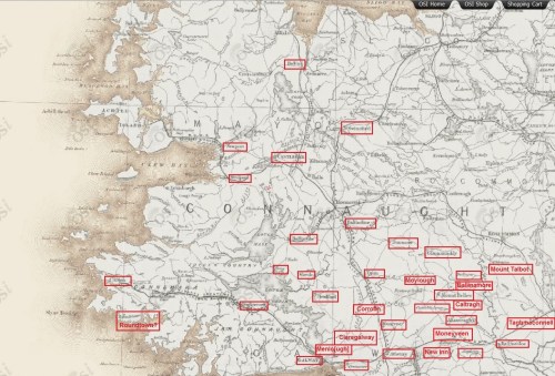
M’Cann and RCC both provide long lists of the destinations they serve:

  • RCC: Athlone, Ballinafad, Ballymahon, Balnacarig, Balnalack, Boyle, Boyne aqueduct, Carrick on Shannon, Castlerea, Colooney, Coolnahay, Downs Bridge, Dromod, Drumsna, Ferns, Glasson, Hill of Down, Junction [which may be the junction between the main line and the Longford Branch], Kenagh, Kilcock, Lanesborough, Leixlip, Longford, Maynooth, Moyvalley, Mullingar, Newcastle, Newtownforbes, Rathowen, Roscommon, Ruskey, Rye aqueduct, Sligo, Terlicken, Thomastown, Toome Bridge
  • M’Cann: Arvagh, Athlone, Ballaghaderin, Ballina, Ballinamore, Ballyfarnon, Ballymahon, Ballymore, Ballymote, Boyle, Carrick on Shannon, Castlerea, Dromod, Drumkerrin [Drumkeeran?], Drumlish, Drumshambo, Drumsna, Dunmore, Edgeworthstown, Elphin, Fenagh, Granard, Lanesborough, Longford, Mohill, Roscommon, Ruskey, Strokestown, Tenelick Mills, Tulsk.

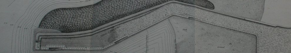
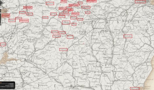
I thought it might be interesting to show these destinations on a map. Note that the map is from the 25″ Ordnance Survey map of around 1900 rather than the 6″ of around 1840: I used it because it was clearer, but it shows features (eg railway lines) that were not present in 1846.

Click on the map to get a slightly larger version.

Royal Canal carriers M'Cann and RCC 1846 (OSI)

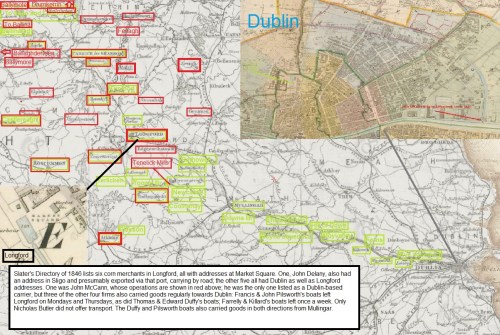
Royal Canal carriers M’Cann and RCC 1846 (OSI)

I can’t stand over every location marked on the map (as it were). Spellings of place-names were sometimes not those in use today; some place-names (Ballinamore, Ballymore, Newcastle) are used of two or more places that might have been those intended; I could not identify two places, Dunmore and Junction, although I suspect the latter may be the junction between the main line and the Longford Branch of the canal.

What is interesting, though, is the different emphases in the two firms’ marketing. The Royal Canal Company lists almost every location along its canal; M’Cann offers a wide range of destinations beyond the canal, presumably linked by cars on the roads, into Counties Longford, Cavan, Roscommon, Westmeath, Mayo and Sligo. The RCC serves some such destinations, but a smaller number of them.

Some of the locations listed are small places; my presumption — which I have not yet checked, but for which I have found some supporting examples — is that such places have mills, quarries or other industries that provide cargoes for the canal.

The Shannon and the roads

Both operators offer to serve destinations on the River Shannon, to which the Royal Canal is joined at Clondra/Richmond Harbour:

  • RCC: Athlone, Carrick on Shannon, Dromod, Drumsna, Glasson, Lanesborough, Ruskey
  • M’Cann: Athlone, Carrick on Shannon, Dromod, Drumshambo, Drumsna, Lanesborough, Ruskey.

It is possible that goods to those places were carried by water, although (if steam tugs were not available) that would have been slow and uncertain; given that there were good roads leading from the west to the Shannon and throughout the region, it is, I think, likely that these destinations were served by road. I have no evidence on the matter save that the directory entries for Carrick-on-Shannon, Drumsna and Jamestown do not mention the availability of water transport.

Some of those destinations were served by direct road services from Dublin:

  • Athlone, Ballina, Castlerea, Dunmore, Longford, Roscommon, Sligo, Thomastown.

Competition presumably kept charges down.

Other carriers

Slater’s Directory lists six corn merchants in Longford, all with addresses at Market Square. One, John Delany, also had an address in Sligo and presumably exported via that port, carrying by road; the other five all had Dublin as well as Longford addresses.

One was John McCann, whose operations are shown in red on the map; he was the only one listed as a Dublin-based carrier, but three of the other four firms also carried goods regularly towards Dublin: Francis & John Pilsworth’s boats left Longford on Mondays and Thursdays, as did Thomas & Edward Duffy’s boats; Farrelly & Killard’s boats left once a week. Only Nicholas Butler did not offer transport. The Duffy and Pilsworth boats also carried goods in both directions from Mullingar. My guess is that carrying goods from others helped these merchants to cover the costs of their own fleets.

Peter Clarke’s Appendix C suggests that M’Cann’s fleet was the smallest of those based in Longford. The list is of “Boat Owners operating on the Royal Canal 1826 to 1847” but I am not entirely clear what the list shows. It seems unlikely, for instance, that the Midland Great Western Railway owned four boats throughout the period, as the company did not exist for most of it. Is the number of boats the largest that an owner had, or used, in a peak year, or an average over several years?

I don’t, therefore, know how to interpret the list but, assuming that the same methods were applied to all owners, it seems that the fleet sizes were these:

  • Duffy Bros 12
  • Pilsworths 9
  • M’Cann 5
  • Royal Canal Company 4.

Neither Farrelly nor Killard is listed, but there are many others: Dunne 8, Kelly 6, Murtagh 6, Murphy 5, MGWR 4, Williamson 4, and many others with 1, 2 or 3 boats each. Again, it is not clear in which years those owners had those numbers of boats.

More

As far as I know, little has been written about the carrying companies, especially those of the nineteenth century. I would be glad to hear from anyone who can correct, supplement or comment on this information.


[i] I Slater’s National Commercial Directory of Ireland: including, in addition to the trades’ lists, alphabetical directories of Dublin, Belfast, Cork and Limerick. To which are added, classified directories of the important English towns of Manchester, Liverpool, Birmingham, Sheffield, Leeds and Bristol; and, in Scotland, those of Glasgow and Paisley. Embellished with a large new map of Ireland, faithfully depicting the lines of railways in operation or in progress, engraved on steel. I Slater, Manchester, 1846

[ii] Peter Clarke The Royal Canal: the complete story ELO Publications, Dublin 1992

My OSI logo and permit number for website

Canal carrying 1846: Dublin to Waterford

Lowtown is at the western end of the summit level of the Grand Canal; it thus has some claim to be the highest point on the canal. It is close to the village of Robertstown in County Kildare.

Lowtown is also the site of the junction between the main (Dublin to Shannon) line of the Grand Canal and its most important branch, the Barrow Line.

Lowtown (OSI ~1840)

Lowtown (OSI ~1840)

The main line from Dublin comes in from near the bottom right and exits near the top left. The two cuts leaving near the bottom left are the Old and New Barrow Lines, which join together just off the map. The Barrow Line runs to Athy, in south County Kildare, from which the Barrow [river] Navigation runs to the tidal lock at St Mullins, downstream of Graiguenamanagh.

The River Nore joins the Barrow a litle further downstream; the Nore is navigable on the tide upstream to Inistiogue. The combined rivers flow south through the port of New Ross and eventually join the estuary of the River Suir. Turning right at that point takes you up the Suir to Waterford, Carrick-on-Suir and Clonmel. Thus the Barrow Line, from Lowtown, forms an inland waterway link between Dublin and some towns along the Barrow, Nore and Suir.

Isaac Slater’s Directory[i] of 1846 lists those carrying goods on inland waterways. There is a long list for Dublin; entries for other towns list those providing local services. There are some conflicts between the lists (see below).

The map below shows those carrying on the Barrow Line of the Grand Canal and on the rivers Barrow, Nore and Suir. Each carrier is assigned a colour, which is used to frame the name of each place served by that carrier. Some towns (Mountmellick, Carrick-on-Suir, Clonmel) are off the map, further to the west. Note that the map is from the 25″ Ordnance Survey map of around 1900 rather than the 6″ of around 1840: I used it because it was clearer, but it shows features (eg railway lines) that were not present in 1846.

Click on the map to get a slightly larger version.

Dublin to Waterford: inland waterway traders 1846 (OSI)

Dublin to Waterford: inland waterway carriers 1846 (OSI)

Notes

All but one of the carriers are shown as having Dublin premises at Grand Canal Harbour, James Street. The exception is Gaven & Co, which is mentioned only in the Mountmellick entry.

I have not included the Grand Canal Company’s passenger-carrying boats, which carried parcels but not goods.

The City of Dublin Steam Packet Company entry for Dublin does not include Portarlington and Mountmellick amongst the towns served but the entry for Mountmellick says that the company’s boats leave for Dublin every Tuesday and Friday (its agent being John White) while that for Portarlington says they leave weekly. Boats from Mountmellick had to pass through Portarlington as well as Monastereven and other towns en route to Dublin.

Similarly, the entry for Mountmellick says that the Hylands boats leave there every other day while that for Portarlington says that they pass through weekly.

There is a page missing from the electronic copy of the directory that I consulted so the entry for Monastereven is incomplete.

The entry for Carlow says

To DUBLIN, and also to [New] ROSS, Boats depart, at uncertain periods, from the Wharfs of Lawrence and James Kelly, the Quay.

It does not say whether Lawrence and James Kelly owned any boats. They may have had boats but used them only for their own goods.

The entry for Mountmellick says “Bryan Hyland” rather than “B Hylands”.

The entry for Mountmellick includes the only mention I have found of Gaven & Co’s boats (James Waldron, agent).

The entry for Rathangan says

There are Boats for the conveyance of Goods, but no fixed period of departure.

Thomas Berry & Co, the most important carrier on the Grand Canal, did not venture south of Lowtown.

More

As far as I know, little has been written about the carrying companies, especially those of the nineteenth century. I would be glad to hear from anyone who can correct, supplement or comment on this information.


[i] I Slater’s National Commercial Directory of Ireland: including, in addition to the trades’ lists, alphabetical directories of Dublin, Belfast, Cork and Limerick. To which are added, classified directories of the important English towns of Manchester, Liverpool, Birmingham, Sheffield, Leeds and Bristol; and, in Scotland, those of Glasgow and Paisley. Embellished with a large new map of Ireland, faithfully depicting the lines of railways in operation or in progress, engraved on steel. I Slater, Manchester, 1846

My OSI logo and permit number for website

Mad foreigners

The August 2013 issue of Practical Boat Owner has just arrived. It has an article by Dick Everitt called “Mind your head …” in which he talks of dangers to boats from above rather than below: dangers from bridges and from electric power lines. He points out that electricity can jump to a metal mast and says:

So a safe clearance distance is given on the chart with a lightning-type symbol and in some countries a big warning sign is positioned nearby too. But do check local Notices to Mariners as long power cables can sag over time, reducing their official charted clearances.

Aren’t foreigners funny? Imagine having electricity suppliers actually telling boaters about the safe clearance under power cables! That would never happen here ….

I have spent several years trying to get ESB to tell me the safe clearances for cables across the Shannon. I thought I was getting somewhere at one stage but nothing happened. Perhaps ESB would prefer boaters to fry than risk getting sued for getting the clearance wrong.

Shannon traffic to June 2013

The figures for Shannon lock passages to the end of June 2013 are now available. The decline continues, though perhaps more slowly.

Shannon traffic Jan to June percent

Shannon lock and bridge passages January to June as percentages of the 2003 number

The usual caveats apply: the underlying figures (kindly supplied by Waterways Ireland) do not record total waterways usage because, for instance, sailing, fishing or waterskiing on lakes or river stretches, which did not involve a passage through a lock or Portumna Bridge, would not be recorded. The passage records are our only consistent long-term indicator of usage of the Shannon but they would not show, for instance, a change in the balance of types of activities from those in larger cruising boats to those in smaller (sailing, fishing, waterskiing) boats. It is quite possible, therefore, that overall usage might be increasing while long-distance cruising was declining.

Shannon traffic Jan to June private

Shannon lock and bridge passages by private boats January to June

As it happens, the figures show a small increase over 2012 in passages by private boats. I suspect that July’s warm weather will spur a further increase.

Folk living in Ireland, whether owners or prospective hirers, are likely to be able to react quickly to better (or worse) weather by doing more (or less) boating; folk living abroad may be less able to change their holiday plans. Accordingly, July’s weather might (I’m speculating here) mean an increase in passages by private boats and by boats hired by Irish residents; it might not lead to an increase in hiring from abroad.

Traffic in hired boats continued to decline in June.

Shannon traffic Jan to June hire

Shannon lock and bridge passages by hired boats January to June

That decline outweighed the small increase in private traffic, leading to an overall decline in the first six months as compared with the same period in 2012, which itself continued the pattern set in 2007.

Shannon traffic Jan to June all

Shannon lock and bridge passages by all boats January to June

I wondered whether the figures might show any change in the geographical distribution of activity. WI’s reports don’t show separate figures for private and hired boats for the individual locks, but it seems to me that the hire business is becoming more concentrated on northern waters, from Lough Ree upwards. If that is so, then there might be an increase in the proportion of passages through the northern locks, from Tarmonbarry upwards, and a decrease in the proportion passing through Portumna Bridge and Meelick (Victoria) Lock.

I put the WI reporting stations in four groups:

  • Portumna + Meelick
  • Athlone
  • Tarmonbarry, Clondra, Roosky, Jamestown (Albert), Knockvicar (Clarendon)
  • the also-rans: the three locks leading to Lough Allen, Pollboy leading to Ballinasloe, the Limerick sea-lock (Sarsfield).

The figures suggest that the distribution is indeed changing, but gradually rather than dramatically. Athlone’s figures are pretty steady, the outliers are declining slightly and Portumna + Meelick are declining a bit more; the northern locks (Tarmonbarry to Knockvicar) are taking the gains. Comments or alternative interpretations welcome.

Change by region

Lock passages by group

The figures for 2013 are for the six months January to June; those for other years are for twelve months.

The locks could of course be grouped in other ways, and I may try some of them in future months.

Waterproof wireless telegraphy

A couple of weeks ago I wrote about wireless telegraphy, concluding that:

At present, the rational decision for a boat-owner is to buy a cheap VHF without bothering to get either a certificate for the operator or a licence for the vessel. This is the rational decision because the official channels for getting certificates and licences are slow, expensive and cumbersome. It may therefore be — who knows? — that the populace has already decided to ignore the regulations.

For leisure boating within some sensible distance of the shore, I suggest that the current regulations be either drastically simplified or, perhaps better, scrapped altogether. That might mean giving the International Telecommunication Union a kick up the transom, but the present system is counterproductive: it seems to limit the use of handheld VHFs in cases where they could be very useful, if only to allow search and rescue volunteers to stand down earlier.

Two reports published today by the Marine Casualty Investigation Board have caused me to reconsider that conclusion.

In the Brownstown Head case [Report no MCIB/229; no 11 of 2013] [PDF], two occupants of a 16′ punt were thrown into the water when the boat capsized. They had a handheld VHF in the boat, but it sank when the boat capsized; one occupant put his mobile phone in his mouth to keep it above the water but it was knocked out. As a result, they were unable to summon assisstance. They eventually tried to swim to the shore, but only one made it; the other was drowned.

In the MacDara’s Island Currach case [Report no MCIB/215; no 10 of 2013] [PDF], a fisherman seems to have fallen overboard from a 6.15m open boat, in which he was alone. It was equipped with flares and a VHF in a watertight container, but as the report says:

5.6. There are unique problems with fishing operations from small open boats by lone fishermen. Once they become separated from their vessel their means of communicating their distress are on board their boat and not accessible to them.

In neither of these cases was the possession of a handheld VHF of any use. The VHF sets would have had to be (a) waterproof and (b) securely attached to the boaters’ lifejackets. The report on the MacDara’s Island Currach case recommends:

6.5. That the “Code of Practice for Fishing Vessels under 15 LOA” section 9.5 Radio Equipment should be amended by the addition of a requirement for undecked vessels where there is a lone occupant that an appropriate beacon should be of the type worn on the person.

In fact, the same recommendation could be applied to cases like Brownstown Head, where there were two people in the boat. That is broadly in line with the actions announced by two ministers on 8 July; note Simon Coveney also said:

I am also establishing a new high level working group on safety in the fishing industry, to look at all aspects of safety on fishing vessels and to report to Minister Varadkar and myself with recommendations before the end of the year. The new working group will be chaired by Mr John Leech current CEO of Irish Water Safety. Because a common thread of comment in recent times has been the need to pay particular attention on issues surrounding the number of small inshore boats that get into difficulty, I have charged the group with focussing to a large degree on this aspect.

So the wider use of handheld VHFs won’t solve every problem. I still think, though, that such wider use should be encouraged by the removal of unnecessary barriers.

Inland lifeboats to be exempt from VAT

Irish Water Safety has issued a press release [PDF] saying that the government is to introduce (or launch or make or pass or something) the Value-added tax (refund of tax) (rescue boats and related equipment) order 2013 which will allow inland community rescue boats to reclaim VAT on their purchases. Under the Value-Added Tax (Refund of Tax) (No 18) Order 1985, coastal community rescue boats have been able to reclaim VAT [PDF] but inland boats have not.

Portumna Water Rescue Service

Portumna Water Rescue Service

Irish Water Safety has a defined role in assessing the eligibility of community rescue boats for VAT exemptions; indeed its checklist and guidelines for community rescue services [PDF] are rather surprisingly headed Inspection for VAT Refund Certificate. The background is explained in another document Inshore Rescue Guidelines [PDF], which will presumably now be amended to include provision for inland boats. The “Declared Facility” boats [those approved and able to claim the VAT exemption] are listed here; there is also a list of other known rescue boats, some of which, being on inland waters, will now presumably apply to IWS for approval. Thus what is already a large rescue service will become even larger and more important.

I have photos of some of these boats on this page. I have none of the Corrib & Mask Rescue service, which I regret as today’s announcement was made on their turf and with their assistance. IWS says:

They will be the first Community Rescue Boat Ireland Lifeboat to be in a position to avail of this financial incentive.

Incidentally, I do not know whether the existing inland lifeboats operated by the Coast Guard and RNLI are affected by this or whether they could already reclaim VAT. If anyone can tell me, I’ll be glad to add the information here.

Dialogue

Some time ago I noted that Waterways Ireland was now down wid da kidz in da hood, doing groovy things like social meeja with a Youtube thingie. It features (inter alia) a flight in a helicopter gunship along a restored Clones Sheugh. At least, that’s what I presume was going on, although I couldn’t work out how to fire the rockets at the suspiciously large number of narrowboats found along the way. The scenic highlight of the journey was Clones.

There’s also a Facebook page, from which I learned that there is now a skippered boat available for hire on the Barrow. And there is a Twitter whatsit, which does two interesting things.

First, it has summaries of marine notices, which will be useful to those cruising on the waterways without internet access.

Second, it shows signs of WI’s engaging in public dialogue with users, even when their comments might be critical. This is very welcome; it will be interesting to see the extent to which such public dialogue is permitted to develop.